Michelham Priory

Last updated

Michelham Priory
Michelham Priory 03.jpg
Michelham Priory
East Sussex UK location map.svg
Red pog.svg
Location within East Sussex
Monastery information
Full namePriory of the Holy Trinity
Order Augustine
Established1229
Disestablished1537
Mother house Hastings Priory
Dedicated toHoly Trinity
People
Founder(s) Gilbert de Aquila
Site
Location Upper Dicker, East Sussex
Coordinates 50°51′45″N0°12′50″E / 50.86250°N 0.21389°E / 50.86250; 0.21389
Grid reference TQ 5587 0930
Public accessYes
Website sussexpast.co.uk/attraction/michelham-priory

Michelham Priory is the site of a former Augustinian Priory in Upper Dicker, East Sussex, England, United Kingdom. The surviving buildings are owned and administered by the Sussex Archaeological Society and are Grade I and Grade II listed. [1]

Contents

A T-shaped stone-built structure, the east and north wings date from the 13th century and the west wing from the 16th century. The north wing, originally the Priors Lodging, comprises three storeys with an attic and the other two wings two storeys. The roof is tiled. The whole is surrounded by a moat, enclosing an area of almost 8 acres (3.2 ha). [2]

A watermill in the grounds of the priory has been restored to working order and is open to the public.

History

The medieval priory

The Augustinian Priory of the Holy Trinity was founded at Michelham in 1229 by Gilbert de Aquila, [3] [4] whose father had been a benefactor of Bayham Abbey in Kent and also had connections to Otham Abbey in East Sussex. [5] Michelham was a daughter house of Hastings Priory. [6]

All Gilbert's lands and honours were forfeited in 1235 as punishment for his going to Normandy without licence from King Henry III. [7]

In 1278 and again in 1287, the prior was fined for exercising illegal privileges. [8] On 26 June 1283, John de Kyrkeby renounced his election as Bishop of Rochester at Michelham Priory before John Peckham, Archbishop of Canterbury. [9]

King Edward I stayed overnight at the priory on 14 September 1302. [10] In 1353, the prior was fined 40d because a bridge at Rickney was broken and blocking the river. [11] By 1398, the priory was reported to be in a ruinous condition. Robert Reade, bishop of Chichester, granted the advowsons of Alfriston and Fletching to Michelham Priory in that year. [12]

Dissolution and later use

The Priory was seized in 1537 under Henry VIII during the Dissolution of the monasteries. The priory and its possessions was then granted to Thomas Cromwell. [13] Following Cromwell's execution in 1540, it was granted to Anne of Cleves. Part of it was leased to Thomas Culpeper, with the greater part of the site passing to William, Earl of Arundel. [14] In 1544, Henry, Earl of Arundel exchanged Michelham Priory with Queen Mary for other property. [15] In 1556, the priory was sold to John Foote and John Roberts for £1,249 16s 10d. Foote alienated the manor and hundred of Michelham Parkegate to Ambrose Smythe in 1574. In 1584, Smythe granted it to John Morely and Elizabeth, his wife. Morley granted the priory to Herbert Pelham in 1587. [2]

The church and some of the buildings were demolished between 1599 and 1601.[ citation needed ] In the former year, the priory was made over in trust to Thomas Peirse, Thomas Pelham and James Thatcher to be sold to provide an annuity of £400 and pay off his debts. In 1601, the priory was sold to Thomas Sackville, 1st Earl of Dorset (Lord Buckhurst) for the sum of £4,700. [16] On his death in 1608, the property passed to his son Robert Sackville, 2nd Earl of Dorset. In 1609, it passed to Richard Sackville, 3rd Earl of Dorset. On Richard's death in 1630, the priory passed to his wife, Lady Anne Clifford. On her death in 1675, the property remained in the Sackville family, passing down the Earls (later Dukes) of Dorset until the death of John Sackville, 3rd Duke of Dorset in 1799, then passing to his daughter Mary, Countess of Plymouth. She married William Amherst, 1st Earl Amherst in 1839. [17]

It was sold to James Gwynne in 1896 and was where his children Rupert, Roland and Violet grew up. [18] The property remained in private hands into the 20th century, when it was restored by the Sussex architect and antiquarian, Walter Godfrey. It was used as a base for Canadian troops during the winter of 1941-42 while they prepared for the Dieppe Raid. Later it was the East Sussex headquarters of the Auxiliary Territorial Service.

In 1958 Mrs R.H. Hotblack purchased the property with the aim of preserving it for posterity. With an endowment from Kenneth, Earl of Inchcape as a memorial to his friend John Fletcher Boughey who was killed during the Second World War, Mrs Hotblack gave the property in trust to the Sussex Archaeological Society on 1 November 1959.

Priors of Michelham

Aerial view of Michelham Priory. Barbican tower (centre left), dovecot (centre), refectory (centre right), watermill (bottom left) and barn (bottom centre) Michelham Priory and Barbican Tower.jpg
Aerial view of Michelham Priory. Barbican tower (centre left), dovecot (centre), refectory (centre right), watermill (bottom left) and barn (bottom centre)

The following priors are recorded at Michelham Priory

Italics denotes a possible prior.

Buildings

Barn

Elizabethan Great Barn at Michelham Priory - geograph.org.uk - 1407085.jpg

The barn was built between 1587 and 1610. [30] It is on a timber frame clad with tarred weatherboards. The arched queen post roof is covered with pegtiles. The barn is Grade II listed, [31] and currently serves as a function and meeting room.

Chapter house and dormitory

The chapter house and dormitory stood south of the church, on the east of the site. [32]

Church

The church stood to the north of the surviving refectory. It possessed five bells. No trace of it remains today. [32]
The five bells, cast by unknown founders, collectively weighed 40cwt (2030Kg) and were sold to John Ipingbury for £26 13s 4d at the dissolution of the monasteries. [33]

Dovecot

The old dovecot at Michelham Priory - geograph.org.uk - 1405833.jpg

The dovecot, also described as a stables or pigeon house, is a single-storey building of sandstone, ashlar on the south facing aspect under a hipped pegtile roof. Built in the 18th century, it is a Grade II listed building. [34] The building has been converted to form a shop and tearoom.

Gatehouse

Michelham Priory Gatehouse
Michelham Priory 1.jpg
The gatehouse
Michelham Priory
General information
Coordinates TQ 5581 0938
CompletedEarly C15th
OwnerSussex Archaeological Society
Heightc.50 feet (15 m)
Technical details
Material
  • Stone
  • Peg tile roof
Floor countFour

The gatehouse was built in the early 15th century, [35] during the time when John Leem was prior. [36] A basement at moat level served either as a cellar or prison. [35] The building is about 50 feet (15 m) high and contains four storeys, including the cellar. [37]

In the 16th century, a stone bridge was built over the moat. The gatehouse and bridge are Grade I listed buildings. [38]

Refectory

Refectory, Michelham Priory
Michelham Priory, Upper Dicker, East Sussex - geograph.org.uk - 888729.jpg
The surviving refectory (right) with Prior's house (centre) and post-monastic additions (right)
Michelham Priory
General information
StatusMuseum
Estimated completionC13th (refectory & Prior's house)
C16th (post-monastic addition)
OwnerSussex Archaeological Society
Technical details
Material
  • Sandstone
  • Peg tile roof
Floor countOne, later two (refectory)
Three (post-monastic house)

The surviving refectory building originally contained a hall 40 feet (12 m) long. There was a window at the west end which was 13 feet 6 inches (4.11 m) wide, [32] the outer frame of which survives today. This and the Prior's House are built of sandstone. [39]

At the time of the Dissolution, the refectory was roofless. A second floor was added later and the building was divided into a number of rooms. [40] Adjacent to the refectory is the Prior's House and crypt, which was above ground on account of the low-lying position of the priory and risk of flooding. [41] There is a post-monastic extension on the west, built of stone. The whole is under a pegtile roof. [39]

The refectory had been converted to use as a farmhouse by 1848. [42] The crypt was divided into four rooms and used as a dairy by the 1850s. [41] The whole is a Grade I listed building. [39]

Watermill

Michelham-mh2.JPG

The moat round the priory was formed by damming the River Cuckmere and the watermill is fed by the moat. [43] A watermill is mentioned at Michelham Priory as early as c.1260, [20] In 1411 it was held by Robert de Blachington from William de Wrotham and his wife Joan de Kelle. [44] In 1478, the priory owned two mills, which were both reported to be "in ruins". [45] At the time the priory was dissolved, the mill produced an annual profit of 53s 3d. [46]

The surviving building dates from the mid-C16th. [47] Built on an oak frame, it is of three bays clad with weatherboards and under a pegtile roof. [48] A porch bears the date 1714. The front of the mill was renewed c.1800. A cast iron waterwheel was fitted in 1896. It was removed in 1924–25, [47] the mill having ceased commercial milling in 1924. As well as the waterwheel, the rest of the machinery was removed and the building served as a store. A turbine was installed in the mill race to generate electricity for the main house in the former refectory. It was still working in 1939. [48]

The mill was restored to working order in 1972, new machinery and a new breastshot wooden waterwheel being fitted. The mill is a Grade II listed building. [47] [48] In 1996, the waterwheel was rebuilt and other machinery repaired or replaced as necessary. The work was partly funded by a £42,000 grant from the National Lottery. [48]

See also

Related Research Articles

<span class="mw-page-title-main">Thomas Sackville, 1st Earl of Dorset</span> 16th/17th-century English politician and poet

Thomas Sackville, 1st Earl of Dorset was an English statesman, poet, and dramatist. He was the son of Richard Sackville, a cousin to Anne Boleyn. He was a Member of Parliament and Lord High Treasurer.

<span class="mw-page-title-main">River Darent</span> River in Kent, England

The Darent is a Kentish tributary of the River Thames and takes the waters of the River Cray as a tributary in the tidal portion of the Darent near Crayford. 'Darenth' is frequently found as the spelling of the river's name in older books and maps, Bartholomew's Canals and River of England being one example. Bartholomew's Gazetteer (1954) demonstrates that Darent means "clear water", a result of it springing from and running through chalk. The purity of the water was a major factor in the development of paper and pharmaceuticals in the area.

<span class="mw-page-title-main">Withyham</span> Village and parish in East Sussex, England

Withyham is a village and large civil parish in the Wealden district of East Sussex, England. The village is situated 7 miles south west of Royal Tunbridge Wells and 3.5 miles (5.6 km) from Crowborough; the parish covers approximately 7,500 acres (30 km2).

<span class="mw-page-title-main">Stretton Watermill</span> Historic site in Stretton, Cheshire West and Chester

Stretton Watermill is a working historic watermill in Stretton, Cheshire, England. It is owned and administered by Cheshire West and Chester Council. The mill is recorded in the National Heritage List for England as a designated Grade II* listed building and the mill machinery is considered to be of national importance.

<span class="mw-page-title-main">Bayham Old Abbey</span> English Heritage property near Lamberhurst, Kent, England

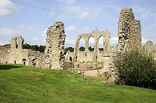
Bayham Old Abbey is an English Heritage property, located near Lamberhurst, Kent, England. Founded c. 1208 through a combination of the failing Premonstratensian monasteries of Otham and Brockley, Bayham functioned as an abbey until its dissolution in the 16th century. The ruins were partially modified in the late 18th century, to provide a better landscape feature during landscaping of the new Bayham Abbey mansion park, and were donated to the state in 1961.

<span class="mw-page-title-main">River Bourne, Kent</span> River in Kent, England

The River Bourne rises in the parish of Ightham, Kent and flows in a generally south easterly direction through the parishes of Borough Green, Platt, Plaxtol, West Peckham, Hadlow, and East Peckham where it joins the River Medway. In the 18th century the river was known as the Busty or Buster, the Shode or Sheet, but is not known by these names nowadays. A bourne is a type of stream, while shode means a branch of a river.

<span class="mw-page-title-main">Loose Stream</span> Stream in Kent, England

The Loose Stream sometimes called the River Loose or Langley Stream is a tributary of the River Medway notable for the number of watermills that it powered in its short length. It rises in Langley, flows through Boughton Monchelsea, Loose and enters the Medway at Tovil. The river valley is deep sided, and there is much evidence of the paper and wool trades which once flourished here: the stream has been dammed in many places, resulting in many mill ponds.

<span class="mw-page-title-main">River Len</span> River in Kent, England

The River Len is a river in Kent, England. It rises at a spring in Bluebell Woods to the southeast of the village centre of Lenham 0.6 miles (0.97 km) from the source of the River Great Stour; both rise on the Greensand Ridge. Its length is c10 miles (16 km). It enters the River Medway at Maidstone.

<span class="mw-page-title-main">Wateringbury Stream</span> River

The Wateringbury stream is a tributary of the River Medway in Kent, England. It rises at Swanton, West Peckham parish, flows south east towards Mereworth and then flows in a generally easterly direction to join the River Medway at Wateringbury. It is some four miles (6 km) long and powered a number of watermills.

<span class="mw-page-title-main">River Beult</span> River in Kent, England

The River Beult is a tributary of the River Medway in South East England.

<span class="mw-page-title-main">East Malling Stream</span> River in Kent, England

The East Malling Stream, known locally as "The Stream", rises at Well Street, East Malling, Kent, and flows in a generally easterly direction to join the River Medway at Mill Hall, Aylesford. It powered six watermills. The stream may have formerly been known as the Bradbourne, Bradbourne Lane in Ditton bearing witness to this name.

The Medway and its tributaries and sub-tributaries have been used for over 1,150 years as a source of power. There are over two hundred sites where the use of water power is known. These uses included corn milling, fulling, paper making, iron smelting, pumping water, making gunpowder, vegetable oil extraction, and electricity generation. Today, there is just one watermill working for trade. Those that remain have mostly been converted. Such conversions include a garage, dwellings, restaurants, museums and a wedding venue. Some watermills are mere derelict shells, lower walls or lesser remains. Of the majority, there is nothing to be seen. A large number of tributaries feed into the River Medway. The tributaries that powered watermills will be described in the order that they feed in. The mills are described in order from source to mouth. Left bank and right bank are referred to as though the reader is facing downstream. This article covers the tributaries that feed in above Penshurst.

The Medway and its tributaries and sub-tributaries have been used for over 1,150 years as a source of power. There are over two hundred sites where the use of water power is known. These uses included corn milling, fulling, paper making, iron smelting, pumping water, making gunpowder, vegetable oil extraction, and electricity generation. Today, there is just one watermill working for trade. Those that remain have mostly been converted. Such conversions include a garage, dwellings, restaurants, museums and a wedding venue. Some watermills are mere derelict shells, lower walls or lesser remains. Of the majority, there is nothing to be seen. A large number of tributaries feed into the River Medway. The tributaries that powered watermills will be described in the order that they feed in. The mills are described in order from source to mouth. Left bank and right bank are referred to as though the reader is facing downstream. This article covers the watermills on the tributaries that feed in below Penshurst and above Yalding.

The River Medway and its tributaries and sub-tributaries have been used for more than 1,150 years as a source of power. There are over two hundred sites where the use of water power is known. Many different processes were performed by the use of water power:- corn milling, fulling, paper making, iron smelting, pumping water, making gunpowder, vegetable-oil extraction, and electricity generation. Today, there is just one watermill working for trade. Those that remain have mostly been converted. Such conversions include a garage, dwellings, restaurants, museums and a wedding venue. Some watermills are mere derelict shells, lower walls or lesser remains. Of the majority, there is nothing to be seen. A large number of tributaries feed into the River Medway. The tributaries that powered watermills will be described in the order that they feed in. The mills are described in order from source to mouth. Left bank and right bank are referred to as though the reader is facing downstream. This article deals with the watermills on the tributaries that feed in below Yalding.

<span class="mw-page-title-main">Robert Sackville, 2nd Earl of Dorset</span> English politician

Robert Sackville, 2nd Earl of Dorset (1561–1609) was an English aristocrat and politician, with humanist and commercial interests.

<span class="mw-page-title-main">Tonbridge Priory</span>

Tonbridge Priory was a priory in Tonbridge, Kent, England that was established in 1124. It was destroyed by fire in 1337 and then rebuilt. The priory was disestablished in 1523. The building stood in 1735, but was a ruin by 1780. The remains of the priory were demolished in 1842 when the South Eastern Railway built the railway through Tonbridge, the original Tonbridge station standing on its site.

<span class="mw-page-title-main">Buckhurst Park, East Sussex</span> English country house and park in East Sussex

Buckhurst Park is an English country house and landscaped park in Withyham, East Sussex. It is the seat of William Sackville, 11th Earl De La Warr.

<span class="mw-page-title-main">Cocking Foundry</span> Historical industrial site

Cocking Foundry is an abandoned iron foundry in the South Downs of England. It was situated to the north of the village of Cocking, West Sussex and was active for most of the 19th century. The foundry's output included wheels for watermills, some of which remain in use.

<span class="mw-page-title-main">Coultershaw Wharf and Beam Pump</span> Rural community in England

Coultershaw Bridge is a rural community situated 1.5 mi (2.4 km) south of the town Petworth in West Sussex, England where the A285 road from Petworth to Chichester crosses the River Rother.

References

  1. Historic England. "MICHELHAM PRIORY (1353289)". National Heritage List for England . Retrieved 14 November 2014.
  2. 1 2 Salzmann 1901, p. 253.
  3. Salzmann 1901, p. 197.
  4. 1 2 Salzmann 1901, p. 214.
  5. Salzmann 1901, p. 201.
  6. Salzmann 1901, p. 199.
  7. Cooper 1853, pp. 130–31.
  8. Salzmann 1901, pp. 201–02.
  9. 1 2 Cooper 1853, p. 144.
  10. Cooper 1853, p. 44.
  11. Salzmann 1901, p. 204.
  12. Cooper 1853, p. 137.
  13. Salzmann 1901, p. 250.
  14. Salzmann 1901, p. 251.
  15. Salzmann 1901, p. 252.
  16. Cooper 1853, p. 161.
  17. Cooper 1853, pp. 161–62.
  18. Pamela Cullen, "Stranger in Blood: The case files on Doctor John Bodkin Adams", 2006
  19. Salzmann 1901, pp. 214–15.
  20. 1 2 3 4 5 Salzmann 1901, p. 216.
  21. 1 2 Cooper 1853, p. 149.
  22. Salzmann 1901, p. 217.
  23. Salzmann 1901, p. 219.
  24. Salzmann 1901, p. 220.
  25. Salzmann 1901, p. 225.
  26. Salzmann 1901, p. 226.
  27. Salzmann 1901, p. 229.
  28. Salzmann 1901, p. 234.
  29. Salzmann 1901, p. 236.
  30. "MICHELHAM PRIORY". Heritagegateway. Retrieved 13 June 2016.
  31. "THE BARNS TO THE SOUTH WEST OF MICHELHAM PRIORY". Heritagegateway. Retrieved 13 June 2016.
  32. 1 2 3 Salzmann 1901, p. 239.
  33. https://archaeologydataservice.ac.uk/library/browse/details.xhtml?recordId=3241307
  34. "THE STABLES OR PIGEON-HOUSE TO THE NORTH WEST OF MICHELHAM PRIORY". Heritagegateway. Retrieved 13 June 2016.
  35. 1 2 Salzmann 1901, p. 243.
  36. Salzmann 1901, p. 221.
  37. Cooper 1853, pp. 153–54.
  38. "BARBICAN TOWER AND BRIDGE OVER THE MOAT AT MICHELHAM PRIORY". Heritagegateway. Retrieved 13 June 2016.
  39. 1 2 3 "MICHELHAM PRIORY". Heritagegateway. Retrieved 13 June 2016.
  40. Salzmann 1901, pp. 239–40.
  41. 1 2 Cooper 1853, p. 156.
  42. Lewis 1848, pp. 69–73.
  43. Cooper 1853, p. 158.
  44. Salzmann 1901, p. 202.
  45. Salzmann 1901, p. 230.
  46. Salzmann 1901, p. 244.
  47. 1 2 3 "PRIORY MILL". Heritagegateway. Retrieved 13 June 2016.
  48. 1 2 3 4 Stidder & Smith 1997, p. 73.

Sources

Further reading

50°51′45.18″N0°12′49.80″E / 50.8625500°N 0.2138333°E / 50.8625500; 0.2138333