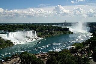
Niagara Falls is a group of three waterfalls at the southern end of Niagara Gorge, spanning the border between the province of Ontario in Canada and the state of New York in the United States. The largest of the three is Horseshoe Falls, which straddles the international border of the two countries. It is also known as the Canadian Falls. The smaller American Falls and Bridal Veil Falls lie within the United States. Bridal Veil Falls is separated from Horseshoe Falls by Goat Island and from American Falls by Luna Island, with both islands situated in New York.
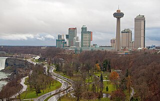
Niagara Falls is a city in Ontario, Canada. It is on the western bank of the Niagara River in the Golden Horseshoe region of Southern Ontario, with a population of 94,415 at the 2021 census. It is part of the St. Catharines - Niagara Census Metropolitan Area (CMA). Incorporated on 12 June 1903, the city is across the river from Niagara Falls, New York. The Niagara River flows over Niagara Falls at this location, creating a natural spectacle which attracts millions of tourists each year.
Welland is a city in the Regional Municipality of Niagara in Southern Ontario, Canada. As of 2021, it had a population of 55,750.

The Maple Leaf is an international passenger train service operated by Amtrak and Via Rail between Pennsylvania Station in New York City and Union Station in Toronto via the Empire Corridor. Daily service is offered in both directions; the 544-mile (875 km) trip takes approximately 12 hours, including two hours for U.S. or Canadian customs and immigration inspection at either Niagara Falls, New York, or Niagara Falls, Ontario. Although the train uses Amtrak rolling stock exclusively, the train is operated by Via Rail crews while in Canada and by Amtrak crews in the United States. Service began in 1981.
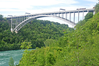
The Lewiston–Queenston Bridge, also known as the Queenston–Lewiston Bridge, is an arch bridge that crosses the Niagara River gorge just south of the Niagara Escarpment. The bridge was officially opened on November 1, 1962. It is an international bridge between the United States and Canada. It connects Interstate 190 in the town of Lewiston, New York to Highway 405 in the community of Queenston, Ontario. The Lewiston–Queenston Bridge is architecturally similar to the Rainbow Bridge at nearby Niagara Falls.
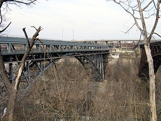
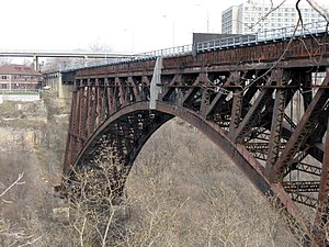
The Whirlpool Rapids Bridge, commonly known as the Whirlpool Bridge or the Lower Steel Arch Bridge, is a spandrel braced, riveted, two-hinged arch bridge that crosses the Canada–United States border, connecting the commercial downtown districts of Niagara Falls, Ontario, and Niagara Falls, New York. This bridge is located approximately 1.5 kilometres (0.9 mi) north of the Rainbow Bridge and about 2 kilometres (1.2 mi) from the Falls. It was acquired by the Niagara Falls Bridge Commission in January 1959. Immediately upstream is the similar arch-style Michigan Central Railway Bridge, which has been out of service since 2001.
The Peace Bridge is an international bridge between Canada and the United States at the east end of Lake Erie at the source of the Niagara River, about 20 kilometres (12.4 mi) upriver of Niagara Falls. It connects Buffalo, New York, in the United States to Fort Erie, Ontario, in Canada. It is operated and maintained by the binational Buffalo and Fort Erie Public Bridge Authority.

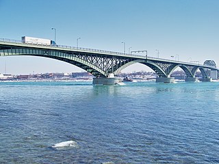
The Niagara Falls International Rainbow Bridge, commonly known as the Rainbow Bridge, is a steel arch bridge across the Niagara River, connecting the cities of Niagara Falls, New York, United States, and Niagara Falls, Ontario, Canada.

The Michigan Central Railroad was originally chartered in 1832 to establish rail service between Detroit, Michigan, and St. Joseph, Michigan. The railroad later operated in the states of Michigan, Indiana, and Illinois in the United States and the province of Ontario in Canada. After about 1867 the railroad was controlled by the New York Central Railroad, which later became part of Penn Central and then Conrail. After the 1998 Conrail breakup, Norfolk Southern Railway now owns much of the former Michigan Central trackage.

The Niagara Cantilever Bridge or Michigan Central Railway Cantilever Bridge was a cantilever bridge across the Niagara Gorge. An international railway-only bridge between Canada and the United States, it connected Niagara Falls, New York, and Niagara Falls, Ontario, located just south of the Whirlpool Bridge, and opened to traffic in 1883, it was replaced by the Michigan Central Railway Steel Arch Bridge in 1925.

The Niagara Falls Suspension Bridge stood from 1855 to 1877 across the Niagara River and was the world's first working railway suspension bridge. It spanned 825 feet (251 m) and stood 2.5 miles (4.0 km) downstream of Niagara Falls, where it connected Niagara Falls, Ontario to Niagara Falls, New York. Trains used the upper of its two decks, while pedestrians and carriages used the lower. The bridge was the idea of Canadian politicians, and it was built by an American company and a Canadian company. It was most commonly called the Suspension Bridge, although other names included Niagara Railway Suspension Bridge, Niagara Suspension Bridge, and its official American name of the International Suspension Bridge.
The Buffalo and Niagara Falls Railroad was a part of the New York Central Railroad system, connecting Buffalo, New York to Niagara Falls. It is still used by CSX for freight and Amtrak for passenger service.

Niagara Falls station is a railway station in Niagara Falls, Ontario, Canada. It is served by the Maple Leaf train between Toronto and New York City and is the terminus of GO Transit's Lakeshore West line towards Toronto. The Gothic Revival station building, which was built in 1879 by the Great Western Railway, is a designated heritage railway station. It is also listed on the Canadian Register of Historic Places.

The Canada Southern Railway, also known as CSR, was a railway in southwestern Ontario, Canada, founded on February 28, 1868 as the Erie and Niagara Extension Railway. Its name was changed to Canada Southern Railway on December 24, 1869. The 1868 Act specified that it was to be constructed at a broad gauge of 5 ft 6 in, but that requirement was repealed in the 1869 Act, thus allowing construction at the standard gauge of 4 ft 8+1⁄2 in.

The Great Gorge Route or Niagara Belt Line was an interurban trolley belt line encompassing the Niagara Gorge, operated by the International Railway and Niagara Gorge Railroad. Many dignitaries rode this line and they used to use a flat car with search light to illuminate the Niagara Whirlpool at night.
The Niagara Gorge Railroad was an interurban railway which ran at the bottom of the Niagara Gorge from Niagara Falls, New York to Lewiston, New York.

New York State Route 61 (NY 61) is a state highway located almost entirely in the city of Niagara Falls in Niagara County, New York, in the United States. The road runs across the city in a northwest–southeast direction, terminating at NY 384 at its southern extent and NY 104 at its northern tip. Conceptually, the road, known as Hyde Park Boulevard, forms the eastern border of downtown Niagara Falls. It is the second-shortest two-digit route in New York after NY 71 in Columbia County. The NY 61 designation was in 1958 after being approved by the Niagara Falls City Council.

The Niagara Falls Station and Customhouse Interpretive Center is an intermodal transit complex in Niagara Falls, New York. It serves Amtrak trains and Niagara Frontier Transportation Authority buses, houses U.S. Customs and Border Protection offices servicing the Canada–United States border, and houses the Niagara Falls Underground Railroad Heritage Center.

The Niagara Rainbow, known as the Empire State Express before 1976, was an American passenger train service operated by Amtrak between New York City and Detroit via Buffalo and Southwestern Ontario in Canada. The service ran between October 31, 1974, and January 31, 1979.

