
Youlton is a village and civil parish in Hambleton District of North Yorkshire, England. It is situated approximately 5 miles (8 km) south-west of Easingwold and 11 miles (18 km) from York. The population of the civil parish at the 2011 census was fewer than 100. Details are included in the civil parish of Aldwark.
Birdforth is a village and civil parish in the Hambleton district of North Yorkshire, England. According to the 2001 census it had a population of 13. The population remained less than 100 at the 2011 Census. Details are included in the civil parish of Long Marston, North Yorkshire. The village is on the A19 road, about six miles south of Thirsk.

Overton is a small village and civil parish in the Hambleton district of North Yorkshire, England, about 4 miles (6.4 km) north-west of York. The population of civil parish taken at the 2011 Census was less than 100. Details are included in the civil parish of Shipton, North Yorkshire. The East Coast Main Line passes to the east, not far from the village.

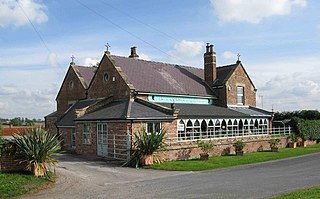
Huby is a village and civil parish in the Hambleton District of North Yorkshire, England, about nine and a half miles north of York and five miles south-east of Easingwold. The village has a small shop, post office, fish and chip shop, a Chinese takeaway, a pub, motel rooms, a Methodist church, a sports ground complete with a pavilion, a B&B motel and a village hall.
Thirlby is a village and civil parish in former Hambleton District of North Yorkshire, England. With a population of about 120 in 2003, measured at 134 at the 2011 Census, Thirlby is situated approximately 4 miles (6.4 km) east of Thirsk.

North Kilvington is a hamlet and civil parish in North Yorkshire, England. It is situated just off the A19, about two miles north of Thirsk. In the 2001 census, North Kilvington had a population of 23. The population of the civil parish was estimated at 30 in 2014.

Holme is a small village and civil parish in the Hambleton District of North Yorkshire, England. It is located near Pickhill, Sinderby and Ainderby Quernhow, on the west bank of the River Swale. The population of the civil parish was estimated at 60 in 2014.

Hornby is a village and civil parish in the Hambleton district of North Yorkshire, England. It lies on a minor road between Great Smeaton and Appleton Wiske.

South Cowton is a village and civil parish located on the site of an abandoned medieval village in the Hambleton district of North Yorkshire in England. The population of the civil parish taken at the 2011 census was 188.

Deighton is a village and civil parish in the Hambleton District of North Yorkshire, England. It is about 6 miles north of Northallerton and near the A167 road.
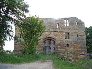
Whorlton is a hamlet and civil parish in the Hambleton District of North Yorkshire, England. It is very near Swainby and the A19, and 6 miles south west of Stokesley. Features include the remains of Whorlton Castle and the Church of the Holy Rood.

Warlaby is a small village and civil parish in the Hambleton District of North Yorkshire, England. The population of the civil parish taken at the 2011 Census was less than 100. Details are included in the civil parish of Ainderby Steeple. In 2015, North Yorkshire County Council estimated the population to be around 50 people. It is near the A684 and Morton-on-Swale. It is 1.6 miles (2.5 km) west of Northallerton.

Hutton Rudby is a village and civil parish situated 4 miles (6.4 km) west of the market town of Stokesley in North Yorkshire, England. At the 2011 census, the village's parish and built-up area subdivision had a population of 1,572 while its main population had a population of 1,968.
Howe is a small village and civil parish in the Hambleton District of North Yorkshire, England. It is situated near Ainderby Quernhow and the A61 and 5 miles (8 km) west of Thirsk. The population of the civil parish was estimated at 20 in 2015.

Kirby Knowle is a village and civil parish in Hambleton District of North Yorkshire, England, on the border of the North Yorkshire Moors and near Upsall, about four miles northeast of Thirsk. Historically part of the North Riding of Yorkshire, the population of the civil parish was estimated at 60 in 2014.

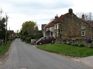
Kirkby is a village and civil parish in Hambleton district of North Yorkshire, England, near Great Busby and 2 miles (3.2 km) south of Stokesley. The village is mentioned in the Domesday Book as belonging to Uhtred. The name of the village derives from the Old Norse kirkju-býr, which means church with a village. At the 2001 Census, the population of the village was recorded at 313, dropping slightly to 309 at the 2011 Census. In 2015, North Yorkshire County Council estimated the population to be 310.

Rudby is a village and civil parish, 4 miles (6.4 km) from the market town of Stokesley in the North Yorkshire, England.
Sexhow is a hamlet and civil parish in Hambleton district of North Yorkshire, England. The name of the hamlet derives from Old Norse of either sexhou or sekkshaughr, which means the hill of Sekk, a personal name. The population taken at the 2011 Census was less than 100, so details of the population are included on the civil parish of Potto. However, in 2015, North Yorkshire County Council estimated the population to be 20. It is on the River Leven and 5 miles (8 km) west of Stokesley.

Rookwith is a hamlet and civil parish in the Hambleton district of North Yorkshire, England, about 4 miles (6.4 km) west of Bedale and near the flow of the River Ure. The hamlet was mentioned in the Domesday Book as belonging to Count Alan and having four ploughlands.
Skutterskelfe is a civil parish in the Hambleton district of North Yorkshire, England and lies to the north of the River Leven. The population of the parish at the 2011 census was 129.


