


Midmar is a historic settlement in Aberdeenshire, lying north of Banchory and southwest of Inverurie. It is noted for its three stone circles and various standing stones. Midmar and Sunhoney are both recumbent stone circles.
Midmar is a historic settlement in Aberdeenshire, lying north of Banchory and southwest of Inverurie. It is noted for its three stone circles and various standing stones. Midmar and Sunhoney are both recumbent stone circles.
The name Midmar, formerly Migmar, [1] is of Pictish origin. [1] The first element is mig- meaning "bog, swamp" (c.f. Welsh mig(n)), [1] while the second is the district name Mar . [1]
Midmar is a largely rural community, and links to Midmar Castle and Midmar Manor House. The castle dates from the 16th century. [2] The current church dates from 1787. [3] The previous church, St Nidian's, was located over half a kilometre to the south and now forms part of a scheduled monument that includes a medieval motte known as Cunningar Motte. [4] [5]
The oil boom in the 1970s created a temporary burst in building due to the village's proximity to Aberdeen. [6]
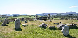
Midmar stone circle lies adjacent to the parish church. The 17m diameter circle features stones up to 2.45m high. [3] The stones have been described as "fang-like". [7] In 1914, the stones were disturbed by the construction of a new graveyard. [3] The circle was scheduled as an ancient monument in 1925 and 1970. [8]
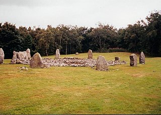
Sunhoney stone circle lies slightly east of the village at Sunhoney Farm. [9] Cullerlie stone circle lies further east. [10] Sunhoney and Midmar are both recumbent stone circles whilst Cullerlie is thought to be a later version. [11]
The three circles are supplemented by other standing stones of similar date, scattered throughout the area.[ citation needed ] One example is a standing stone 100 metres north of the Midmar circle. [8]
Several hamlets are associated with Midmar. One of these, Bankhead, has a former free church chapel (now converted to a domestic residence) that is a category B listed building. [12]

A recumbent stone circle is a type of stone circle that incorporates a large monolith, known as a recumbent, lying on its side. They are found in only two regions: in Aberdeenshire in the north-east of Scotland and in the far south-west of Ireland in the counties of Cork and Kerry. In Ireland, the circles are now more commonly called Cork–Kerry or axial stone circles. They are believed by some archaeologists such as Aubrey Burl to be associated with rituals in which moonlight played a central role, as they are aligned with the arc of the southern moon. Recent excavations at Tomnaverie stone circle have suggested that no alignment of the circle was intended.

Old Deer is a parish and village in the district of Buchan, Aberdeenshire, Scotland. The population in 2011 was 152. The village lies on the Deer or South Ugie Water, 10.1 miles (16.3 km) west of Peterhead and 2 miles (3 km) from Mintlaw. Industries include distilling, brewing, and the manufacture of woollens, and there are quarries of granite and limestone.

Echt is an Aberdeenshire crossroads village in northeast Scotland with a population of approximately 300 people. Echt has a number of prehistoric remains, including the Barmekin of Echt which is on a hill to the northwest. There is also the Cullerlie stone circle near Sunhoney Farm, which may date from the Bronze Age.
There are many large stones of Scotland of cultural and historical interest, such as the distinctive Pictish stones.

Saddell Abbey is a ruined Cistercian monastery located in western Scotland. The abbey was established in 1160 by Somerled, Lord of Kintyre, who was killed in 1164. The abbey was completed by his son, Ragnall, a few years later. The original layout of the abbey included a church and three adjoining buildings grouped around a cloister. Saddell Abbey is widely known for its important collection of life-sized stone carvings and burial slabs that were constructed from the 14th to the 16th centuries. Historic Environment Scotland established the site as a scheduled monument in 1975.

Logierait is a village and parish in Atholl, Scotland. It is situated at the confluence of the rivers Tay and Tummel, 500 metres west of the A9 road in Perth and Kinross.

Arbirlot is a village in a rural parish of the same name in Angus, Scotland. The current name is usually presumed to be a contraction of Aberelliot or Aber-Eliot - both meaning the mouth of the Elliot. It is situated west of Arbroath. The main village settlement is on the Elliot Water, 2+1⁄2 miles (4 km) from Arbroath. There is a Church of Scotland church and a primary school. The school lies 1 mile (1.6 km) further west, in the approximate geographic centre of the parish.

Strichen stone circle is a Megalithic recumbent stone circle located near Strichen, Aberdeenshire in the north east of Scotland. It has been destroyed twice and in the early 1980s was excavated and reconstructed.

Sheldon stone circle is a prehistoric stone circle located to the south of Oldmeldrum in Aberdeenshire, Scotland.

Auld Bourtreebush is a large Neolithic stone circle near Portlethen in Aberdeenshire, Scotland. It is also known as Old Bourtree Bush or Old Bourtreebush. This megalithic construction is situated near the Aquhorthies recumbent stone circle and the Causey Mounth, an ancient trackway which connects the Scottish Lowlands to the highlands. It is a scheduled monument.

Easter Aquhorthies stone circle, located near Inverurie in north-east Scotland, is one of the best-preserved examples of a recumbent stone circle and one of the few that still have their full complement of stones and the only one that has all its stones still standing without having been re-erected. It stands on a gentle hill slope about 1 mile (1.6 km) west of Inverurie and consists of a ring of nine stones, eight of which are grey granite and one red jasper. Two more grey granite stones flank a recumbent of red granite flecked with crystals and lines of quartz. The circle is particularly notable for its builders' use of polychromy in the stones, with the reddish ones situated on the SSW side and the grey ones opposite. The discovery of a possible cist covered by a capstone at the centre of the circle indicates that there may once have been a cairn there, but only a conspicuous bump now remains.

Sunhoney is a stone circle of the recumbent type, which is common in the Grampian region, in particular at the River Dee. Sunhoney is situated about 2 km west of Echt in Aberdeenshire, near to the Cullerlie and Midmar stone circles. It is designated a scheduled ancient monument

The Ardlair Stone is a class I Pictish stone that stands in a field in Ardlair, Kennethmont, Aberdeenshire, Scotland. It is associated with a number of other stones that have been proposed by some to be the remains of a recumbent stone circle.
Tomnaverie stone circle is a recumbent stone circle set on the top of a small hill in lowland northeast Scotland. Construction started from about 2500 BC, in the Bronze Age, to produce a monument of thirteen granite stones including a massive 6.5-ton recumbent stone lying on its side along the southwest of the circle's perimeter. Within the 17-metre (56 ft) circle are kerb stones encircling a low 15-metre (49 ft) ring cairn but the cairn itself no longer exists.
Loanhead of Daviot stone circle is a recumbent stone circle in Aberdeenshire in lowland northeast Scotland. The circle consists of the recumbent stone with its flankers and a complete set of eight orthostats about 21 metres (69 ft) in diameter surrounding a low kerbed ring cairn which has an open court. However, the present appearance has in part been produced by substantial restoration after archaeological excavation in 1934, and in 1989 by the removal of the stones covering the central court.

Dunnideer stone circle is a mostly destroyed recumbent stone circle located near Insch in Aberdeenshire, Scotland. The three remaining stones lie close to the ruins of Dunnideer Castle. It is a scheduled monument.

Tyrebagger stone circle is located at Dyce, near to Aberdeen in Scotland. It is a complete recumbent stone circle. It was used as a cattle pound in the past and now stands close to the Aberdeen Western Peripheral Route. It is a scheduled monument since 1925.

Aikey Brae is a recumbent stone circle on Parkhouse Hill near Old Deer in Aberdeenshire, Scotland. The recumbent stone is about 21.5 tonnes and there are five stones still erected in total. The site has been excavated most recently by Chris Ball and Richard Bradley. It is a scheduled monument.

Aquhorthies is a Neolithic stone circle near Portlethen in Aberdeenshire, Scotland. The site is composed of a ring cairn and a recumbent stone circle which unusually has two rings. It stands one field away from Auld Bourtreebush stone circle, near to the Causey Mounth. It is a scheduled monument.