Related Research Articles

A geographic information system (GIS) is a type of database containing geographic data, combined with software tools for managing, analyzing, and visualizing those data. In a broader sense, one may consider such a system to also include human users and support staff, procedures and workflows, body of knowledge of relevant concepts and methods, and institutional organizations.
Computational archaeology describes computer-based analytical methods for the study of long-term human behaviour and behavioural evolution. As with other sub-disciplines that have prefixed 'computational' to their name, the term is reserved for methods that could not realistically be performed without the aid of a computer.
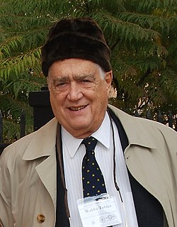
Waldo Rudolph Tobler was an American-Swiss geographer and cartographer. Tobler's idea that "Everything is related to everything else, but near things are more related than distant things" is referred to as the "first law of geography." He has proposed a second law as well: "The phenomenon external to an area of interest affects what goes on inside". Tobler was an active Professor Emeritus at the University of California, Santa Barbara Department of Geography until his death.
A transport network, or transportation network is a network or graph in geographic space, describing an infrastructure that permits and constrains movement or flow. Examples include but are not limited to road networks, railways, air routes, pipelines, aqueducts, and power lines. The digital representation of these networks, and the methods for their analysis, is a core part of spatial analysis, geographic information systems, public utilities, and transport engineering. Network analysis is an application of the theories and algorithms of Graph theory and is a form of proximity analysis.

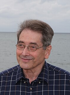
Michael Frank Goodchild is a British-American geographer. He is an Emeritus Professor of Geography at the University of California, Santa Barbara. After nineteen years at the University of Western Ontario, including three years as chair, he moved to Santa Barbara in 1988, as part of the establishment of the National Center for Geographic Information and Analysis, which he directed for over 20 years. In 2008, he founded the UCSB Center for Spatial Studies.
Geographic information science or geographical information science is the scientific discipline that studies geographic information, including how it represents phenomena in the real world, how it represents the way humans understand the world, and how it can be captured, organized, and analyzed. It can be contrasted with geographic information systems (GIS), which are the actual repositories of such data, the software tools for carrying out relevant tasks, and the profession of GIS users. That said, one of the major goals of GIScience is to find practical ways to improve GIS data, software, and professional practice.
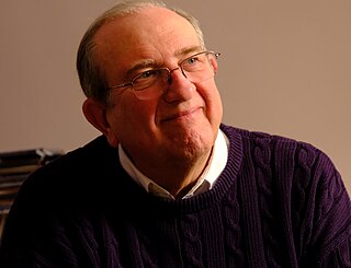
Stephen Grossberg is a cognitive scientist, theoretical and computational psychologist, neuroscientist, mathematician, biomedical engineer, and neuromorphic technologist. He is the Wang Professor of Cognitive and Neural Systems and a Professor Emeritus of Mathematics & Statistics, Psychological & Brain Sciences, and Biomedical Engineering at Boston University.
Map algebra is an algebra for manipulating geographic data, primarily fields. Developed by Dr. Dana Tomlin and others in the late 1970s, it is a set of primitive operations in a geographic information system (GIS) which allows one or more raster layers ("maps") of similar dimensions to produce a new raster layer (map) using mathematical or other operations such as addition, subtraction etc.

Michael George Luby is a mathematician and computer scientist, CEO of BitRipple, Senior Research Scientist at the International Computer Science Institute (ICSI), former VP Technology at Qualcomm, co-founder and former Chief Technology Officer of Digital Fountain. In coding theory he is known for leading the invention of the Tornado codes and the LT codes. In cryptography he is known for his contributions showing that any one-way function can be used as the basis for private cryptography, and for his analysis, in collaboration with Charles Rackoff, of the Feistel cipher construction. His distributed algorithm to find a maximal independent set in a computer network has also been influential.

Michael Lederman Littman is a computer scientist. He works mainly in reinforcement learning, but has done work in machine learning, game theory, computer networking, partially observable Markov decision process solving, computer solving of analogy problems and other areas. He is currently a professor of computer science at Brown University.
Michael Ralph Fellows AC HFRSNZ MAE is a computer scientist and the Elite Professor of Computer Science in the Department of Informatics at the University of Bergen, Norway as of January 2016.
Bin Jiang is Professor in geographic information science, geographic information systems or geoinformatics at the University of Gävle, Sweden. He is affiliated to the Royal Institute of Technology Stockholm (KTH) through the KTH Research School at Gävle. He has been coordinating the Nordic Network in Geographic Information Science (NordGISci), and has organized a series of NordGISci summer schools for the Nordic young researchers. He is the founder and chair of the International Cartographic Association Commission on Geospatial Analysis and Modeling, and has established an ICA workshop series on the research topic. He is also an associate editor of the international journal: Computers, Environment and Urban Systems (Elsevier). He has developed the Head/tail Breaks a new classification for data with a heavy-tailed distribution.
Vernacular geography is the sense of place that is revealed in ordinary people's language. Current research by the Ordnance Survey is attempting to understand the landmarks, streets, open spaces, water bodies, landforms, fields, woods, and many other topological features. These commonly used descriptive terms do not necessarily use the official or current names for features; and often these concepts of places don't have clear, rigid boundaries. For example, sometimes the same name may refer to more than one feature, and sometimes people in a locality use more than one name for the same feature. When people refer to geographical regions in a vernacular form they are commonly referred to as imprecise regions. Regions can include large areas of a country such as the American Midwest, the British Midlands, the Swiss Alps, the south east of England and southern California; or smaller areas such as Silicon Valley in northern California. Commonly used descriptions of areas of cities such as a city's downtown district, New York's Upper East Side, London's square mile or the Latin Quarter of Paris can also be viewed as imprecise regions.
Michael David Mitzenmacher is an American computer scientist working in algorithms. He is Professor of Computer Science at the Harvard John A. Paulson School of Engineering and Applied Sciences and was area dean of computer science July 2010 to June 2013. He also runs My Biased Coin, a blog about theoretical computer science.

Michael Batty CBE, FBA, FRS, FAcSS is a British urban planner, geographer and spatial data scientist, and Bartlett Professor of Planning in The Bartlett at University College London. He has been Director—now Chairman—of the Centre for Advanced Spatial Analysis, set up when he was appointed to UCL in 1995. His research and the work of CASA is focused on computer models of city systems. He was awarded the William Alonso Prize of the Regional Science Association in 2011 for his book Cities and Complexity, the same prize a second time for his book The New Science of Cities in 2017–2018, the University Consortium GIS Research Award in 2012, and the Lauréat Prix International de Géographie Vautrin Lud, the so-called 'Nobel for geography', in 2013. In 2015, he was awarded the Founder's Medal of the Royal Geographical Society and in 2016, the Gold Medal of the Royal Town Planning Institute (RTPI). He also received the Senior Scholar Award of the Complex Systems Society in September 2016.
John Tsotsos is a Canadian Computer Scientist whose research spans the fields of Computer Vision, Human Vision, Robotics, and Artificial Intelligence. He is best known for his work in visual attention, specifically for establishing the need for visual attention in both biological and computational systems through an argument based on the computational complexity of visual information processing and subsequently developing a computational framework for visual attention known as the Selective Tuning model. He is also acknowledged as a pioneer in the area of Active Vision, his students and he being first to propose strategies for active object recognition and object visual search by a robot. He has made many contributions to machine vision (particularly motion interpretation, colour processing, binocular vision, active robotic head design, shape analysis as well as to human vision, robotics and applied areas such as cardiology or dentistry and assistive robotics.
Peter John Diggle, is a British statistician. He holds concurrent appointments with the Faculty of Health and Medicine at Lancaster University, and the Institute of Infection and Global Health at the University of Liverpool. From 2004-2008 he was an EPSRC Senior Research Fellow. He is one of the founding co-editors of the journal Biostatistics.
Andrew U. Frank was a Swiss-Austrian professor for geoinformation at Vienna University of Technology from 1992 until 2016. Previously he was Professor at the University of Maine at Orono. Frank was recognized for his achievements in the fields of spatial information theory, spatial database theory, and ontology in GIS in a special section in his honor in IJGIS.
CyberGIS, or cyber geographic information science and systems, is an interdisciplinary field combining cyberinfrastructure, e-science, and geographic information science and systems (GIS). CyberGIS has a particular focus on computational and data-intensive geospatial problem-solving within various research and education domains. The need for GIS has extended beyond traditional forms of geographic analysis and study, which includes adapting to new sources and kinds of data, high-performance computing resources, and online platforms based on existing and emerging information networks. The name cyberGIS first appeared in Geographic Information Science literature in 2010. CyberGIS is characterized as digital geospatial ecosystems. These systems are developed and have evolved through heterogeneous computing environments, as well as human communication and information environments. CyberGIS can be considered a new generation of geographic information systems (GIS). These systems are based on advanced computing and information infrastructure, which analyze and model geospatial data, providing computationally intensive spatial analysis, modeling, and collaborative geospatial problem-solving at previously unprecedented scales.

Journal of Spatial Information Science is a peer-reviewed open access academic journal covering geographical information science. It is published by the University of Maine and the editors-in-chief are Ross Purves, Benjamin Adams, and Somayeh Dodge. Mike Worboys, Matt Duckham, and Jörg-Rüdiger Sack were the founding editors of the journal when it was established in 2010.
References
- ↑ "JOSIS FAQ". Journal of Spatial Information Science. University of Maine . Retrieved 12 February 2020.