Mineral resource estimation

Last updated

Mineral resource estimation is used to determine and define the ore tonnage and grade of a geological deposit, from the developed block model. There are different estimation methods used for different scenarios dependent upon the ore boundaries, geological deposit geometry, grade variability and the amount of time and money available. A typical resource estimation involves the construction of a geological and resource model with data from various sources. Depending on the nature of the information and whether the data is hard copy or computerized, the principal steps of computer resource estimation are:

Contents

  1. Creation, standardization and validation of the database.
  2. Section plotting and interactive geological modeling.
  3. Geostatistical analysis.
  4. Block modeling and block estimation.

Geological modelling

An orebody model serves as the geological basis of all resource estimation, an orebody modeling project starts with a critical review of existing drill hole and surface or underground sample data as well as maps and plans with current geological interpretation. Drill hole and/or sample databases are set up to suit all the quantitative and qualitative information necessary to build a resource model. The creation of a geological model may include the following steps:

Block model estimation

Once the geological modeling is completed, the geological envelopes are divided into block models. Subsequently, the estimation of these blocks is done from "composites" that are point measures of the grade of ore in the rock. Several different mathematical methods can be used to do the estimation depending on the desired degree of precision, quality and quantity of data and of their nature.

Nearest neighbor method

The nearest neighbor method assigns grade values to blocks from the nearest sample point to the block. Closest sample gets a weight of one; all others get a weight of zero. In two dimensions, this method generates a Voronoi diagram composed of polygons each with a unique grade; in three dimensions this method generates a Voronoi diagram composed of polyhedra each with a unique grade.

20 points and their Voronoi cells (larger version below). Euclidean Voronoi diagram.svg
20 points and their Voronoi cells (larger version below).

In mathematics, a Voronoi diagram is a partitioning of a plane into regions based on distance to points in a specific subset of the plane. That set of points (called seeds, sites, or generators) is specified beforehand, and for each seed there is a corresponding region consisting of all points closer to that seed than to any other. These regions are called Voronoi cells. The Voronoi diagram of a set of points is dual to its Delaunay triangulation. Put simply, it's a diagram created by taking pairs of points that are close together and drawing a line that is equidistant between them and perpendicular to the line connecting them. That is, all points on the lines in the diagram are equidistant to the nearest two (or more) source points.

Advantages

Disadvantages

Inverse distance weighting method

The name "inverse distance weighting method" was motivated by the weighted average applied, since it resorts to the inverse of the distance to each known point ("amount of proximity") when assigning weights.

The simplest weighting function in common usage is based upon the inverse of the distance of the sample from the point to be estimated, usually raised to the second power, although higher or lower powers may be useful. [1]

Samples closer to the point of interest get a higher weighting than samples farther away. Samples closer to the point of estimation are more likely to be similar in grade. Such inverse distance techniques introduce issues such as sample search and declustering decisions, and cater for the estimation of blocks of a defined size, in addition to point estimates.

Inverse distance interpolation for different power parameters p, from scattered points on the surface
z
=
exp
[?]
(
-
x
2
-
y
2
)
{\displaystyle z=\exp(-x^{2}-y^{2})}
. Shepard interpolation 2.png
Inverse distance interpolation for different power parameters p, from scattered points on the surface .

Advantages

Disadvantages

Kriging

In statistics, originally in geostatistics, Kriging or Gaussian process regression is a method of interpolation for which the interpolated values are modeled by a Gaussian process governed by prior covariances, as opposed to a piecewise-polynomial spline chosen to optimize smoothness of the fitted values. [2] Under suitable assumptions on the priors, Kriging gives the best linear unbiased prediction of the intermediate values. Interpolating methods based on other criteria such as smoothness need not yield the most likely intermediate values. The method is widely used in the domain of spatial analysis and computer experiments. The technique is also known as Wiener–Kolmogorov prediction, after Norbert Wiener and Andrey Kolmogorov.

Example of one-dimensional data interpolation by Kriging, with confidence intervals. Squares indicate the location of the data. The Kriging interpolation, shown in red, runs along the means of the normally distributed confidence intervals shown in gray. The dashed curve shows a spline that while smooth nevertheless departs significantly from the expected intermediate values given by those means. Example of kriging interpolation in 1D.png
Example of one-dimensional data interpolation by Kriging, with confidence intervals. Squares indicate the location of the data. The Kriging interpolation, shown in red, runs along the means of the normally distributed confidence intervals shown in gray. The dashed curve shows a spline that while smooth nevertheless departs significantly from the expected intermediate values given by those means.

The theoretical basis for the method was developed by the French mathematician Georges Matheron based on the Master's thesis of Danie G. Krige, the pioneering plotter of distance-weighted average gold grades at the Witwatersrand reef complex in South Africa. Krige sought to estimate the most likely distribution of gold based on samples from a few boreholes. The English verb is to krige and the most common noun is Kriging; both are often pronounced with a hard "g", following the pronunciation of the name "Krige".

Advantages

Disadvantages

Resource block model

The block model is created using geostatistics and the geological data gathered through drilling of the prospective ore zone. The block model is essentially a set of specifically sized "blocks" in the shape of the mineralized orebody. Although the blocks all have the same size, the characteristics of each block differ. The grade, density, rock type and confidence are all unique to each block within the entire block model. An example of a block model is shown on the right. Once the block model has been developed and analyzed, it is used to determine the ore resources and reserves (with project economics considerations) of the mineralized orebody. Mineral resources and reserves can be further classified depending on their geological confidence.

Mineral resources

A mineral resource can be explained as a concentration or occurrence of diamonds, natural solid inorganic material, or natural solid fossilized organic material including base and precious metals, coal, and industrial minerals in or on the Earth’s crust in such form and quantity and of such a grade or quality that it has reasonable prospects for economic extraction. The location, quantity, grade, geological characteristics and continuity of a mineral resource are known, estimated or interpreted from specific geological evidence and knowledge. [3]

Inferred Mineral Resource

An inferred mineral resource is that part of a Mineral Resource for which quantity and grade or quality can be estimated on the basis of geological evidence and limited sampling and reasonably assumed, but not verified, geological and grade continuity. The estimate is based on limited information and sampling gathered through appropriate techniques from locations such as outcrops, trenches, pits, workings and drill holes.

Indicated Mineral Resource

An indicated mineral resource is that part of a Mineral Resource for which quantity, grade or quality, densities, shape and physical characteristics, can be estimated with a level of confidence sufficient to allow the appropriate application of technical and economic parameters, to support mine planning and evaluation of the economic viability of the deposit. The estimate is based on detailed and reliable exploration and testing information gathered through appropriate techniques from locations such as outcrops, trenches, pits, workings and drill holes that are spaced closely enough for geological and grade continuity to be reasonably assumed.

Measured Mineral Resource

A measured mineral resource is that part of a Mineral Resource for which quantity, grade or quality, densities, shape, and physical characteristics are so well established that they can be estimated with confidence sufficient to allow the appropriate application of technical and economic parameters, to support production planning and evaluation of the economic viability of the deposit. The estimate is based on detailed and reliable exploration, sampling and testing information gathered through appropriate techniques from locations such as outcrops, trenches, pits, workings and drill holes that are spaced closely enough to confirm both geological and grade continuity.

Mineral reserves

A Mineral Reserve is the economically mineable part of a Measured or Indicated Mineral Resource demonstrated by at least a Preliminary Feasibility Study. This Study must include adequate information on mining, processing, metallurgical, economic and other relevant factors that demonstrate, at the time of reporting, that economic extraction can be justified. A Mineral Reserve includes diluting materials and allowances for losses that may occur when the material is mined. [3]

Probable Mineral Reserve

A probable mineral reserve is the economically mineable part of an Indicated and, in some circumstances, a Measured Mineral Resource demonstrated by at least a Preliminary Feasibility Study. This Study must include adequate information on mining, processing, metallurgical, economic, and other relevant factors that demonstrate, at the time of reporting, that economic extraction can be justified.

Proven Mineral Reserve

A proven mineral reserve is the economically mineable part of a Measured Mineral Resource demonstrated by at least a Preliminary Feasibility Study. This Study must include adequate information on mining, processing, metallurgical, economic, and other relevant factors that demonstrate, at the time of reporting, that economic extraction is justified.

Case history

When the Bre-X Minerals ltd. scandal was revealed in the spring of 1997, it was one of the largest core salting scams in history and galvanised the development of the NI 43–101 reporting standards. While not the first (Tapin Copper salted samples in the 1970s), it is one of the most popular and the catalyst for reporting reform.

Bre-X

Bre-X was a group of companies in Canada. A major part of the group, Bre-X Minerals Ltd. based in Calgary, was involved in a major gold mining scandal when it reported it was sitting on an enormous gold deposit at Busang, Indonesia (in Borneo). Bre-X bought the Busang site in March 1993 and in October 1995 announced significant amounts of gold had been discovered, sending its stock price soaring. Originally a penny stock, its stock price reached a peak at CAD $286.50 (split adjusted) in May 1996 on the Toronto Stock Exchange (TSE), with a total capitalization of over CAD $6 billion. Bre-X Minerals collapsed in 1997 after the gold samples were found to be a fraud. [4]

Emergence of reporting standards

Plainly put, the purpose of the National Instrument 43-101 is to ensure that misleading, erroneous or fraudulent information relating to mineral properties is not published and promoted to investors on the stock exchanges overseen by the Canadian Securities Authority. [5]

The NI 43–101 was created after the Bre-X scandal to protect investors from unsubstantiated mineral project disclosures.

"The gold reserves at (Bre-X's) Busang were alleged to be 200 million ounces (6,200 t), or up to 8% of the entire world's gold reserves at that time. However, it was a massive fraud and there was no gold. The core samples had been faked by salting them with outside gold. An independent lab later claimed that the faking had been poorly done, including the use of shavings from gold jewelry. In 1997, Bre-X collapsed and its shares became worthless in one of the biggest stock scandals in Canadian history." [6]

The promulgation of a codified reporting scheme makes it more difficult for fraud to occur and reassures investors that the projects have been assessed in a scientific and professional manner. However, even properly and professionally investigated mineral deposits are not necessarily economic, nor does the presence of a NI 43-101-, JORC- or SAMREC and SAMVAL-compliant CPR or QPR necessarily mean that it is a good investment.

Similarly, the publication of a complex technical report with all the inherent jargon, technical wording and abstract geological, metallurgical and economic information may not actually significantly advantage an investor who is not able to fully nor properly understand the content or importance of this information. In this way the NI 43–101 may not serve the interests of those it is designed to protect— the retail investors who may easily misinterpret such information.

Two main regulatory documents exist depending on the national jurisdiction the company is filed with. In Canada, the National Instrument 43-101 report details requirements of reporting mineralized findings. In Australia, the Joint Ore Reserves Committee Code (JORC Code), and South Africa mandates the South African Code for the Reporting of Mineral Resources and Mineral Reserves (SAMREC). All 3 codes are similar but not identical on requirements, definitions, and terminology. Regardless of the technicalities of each document, all exist to:

The establishment and subsequent revisions of the NI 43 101 document by the Ontario Securities Commission provides a framework to adhere to when writing the report. By establishing these standards, investors are able to have a more reliable and honest review of potential mineralized zones.

See also

Related Research Articles

Geostatistics is a branch of statistics focusing on spatial or spatiotemporal datasets. Developed originally to predict probability distributions of ore grades for mining operations, it is currently applied in diverse disciplines including petroleum geology, hydrogeology, hydrology, meteorology, oceanography, geochemistry, geometallurgy, geography, forestry, environmental control, landscape ecology, soil science, and agriculture. Geostatistics is applied in varied branches of geography, particularly those involving the spread of diseases (epidemiology), the practice of commerce and military planning (logistics), and the development of efficient spatial networks. Geostatistical algorithms are incorporated in many places, including geographic information systems (GIS).

<span class="mw-page-title-main">Economic geology</span> Science concerned with earth materials of economic value

Economic geology is concerned with earth materials that can be used for economic and industrial purposes. These materials include precious and base metals, nonmetallic minerals and construction-grade stone. Economic geology is a subdiscipline of the geosciences; according to Lindgren (1933) it is “the application of geology”. Today, it may be called the scientific study of the Earth's sources of mineral raw materials and the practical application of the acquired knowledge.

Bre-X was a group of companies in Canada. Bre-X Minerals Ltd., a major part of Bre-X based in Calgary, was involved in a major gold mining scandal when it reported it was sitting on an enormous gold deposit at Busang, East Kalimantan, Indonesia. Bre-X bought the Busang site in March 1993 and in October 1995 announced significant amounts of gold had been discovered, sending its stock price soaring. Originally a penny stock, its stock price reached a peak at CAD$286.50 in May 1996 on the Toronto Stock Exchange (TSE), with a total capitalization of over CAD $6 billion. Bre-X Minerals collapsed in 1997 after the gold samples were found to be fraudulent.

<span class="mw-page-title-main">Kriging</span> Method of interpolation

In statistics, originally in geostatistics, kriging or Kriging, also known as Gaussian process regression, is a method of interpolation based on Gaussian process governed by prior covariances. Under suitable assumptions of the prior, kriging gives the best linear unbiased prediction (BLUP) at unsampled locations. Interpolating methods based on other criteria such as smoothness may not yield the BLUP. The method is widely used in the domain of spatial analysis and computer experiments. The technique is also known as Wiener–Kolmogorov prediction, after Norbert Wiener and Andrey Kolmogorov.

<span class="mw-page-title-main">Mining engineering</span> Engineering discipline

Mining in the engineering discipline is the extraction of minerals from underneath, open pit, above or on the ground. Mining engineering is associated with many other disciplines, such as mineral processing, exploration, excavation, geology, and metallurgy, geotechnical engineering and surveying. A mining engineer may manage any phase of mining operations, from exploration and discovery of the mineral resources, through feasibility study, mine design, development of plans, production and operations to mine closure.

In spatial statistics the theoretical variogram, denoted , is a function describing the degree of spatial dependence of a spatial random field or stochastic process . The semivariogram is half the variogram.

There are several classification systems for the economic evaluation of mineral deposits worldwide. The most commonly used schemes base on the International Reporting Template, developed by the CRIRSCO - Committee for Mineral Reserves International Reporting Standards, like the Australian Joint Ore Reserves Committee - JORC Code 2012, the Pan-European Reserves & Resources Reporting Committee' – PERC Reporting Standard from 2021, the Canadian Institute of Mining, Metallurgy and Petroleum - CIM classification and the South African Code for the Reporting of Mineral Resources and Mineral Reserves (SAMREC). A more detailed description of the historical development concerning reporting about mineral deposits can be found on the PERC web site.

<span class="mw-page-title-main">Georges Matheron</span>

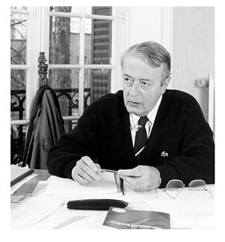
Georges François Paul Marie Matheron was a French mathematician and civil engineer of mines, known as the founder of geostatistics and a co-founder of mathematical morphology. In 1968, he created the Centre de Géostatistique et de Morphologie Mathématique at the Paris School of Mines in Fontainebleau. He is known for his contributions on Kriging and mathematical morphology. His seminal work is posted for study and review to the Online Library of the Centre de Géostatistique, Fontainebleau, France.

Regionalized variable theory (RVT) is a geostatistical method used for interpolation in space.

<span class="mw-page-title-main">Challenger mine</span>

The Challenger mine is a gold mine in the Far North of South Australia, 165 km west of the Stuart Highway and 740 km north-west of Adelaide. It was operated by Dominion, Kingsgate and then WPG Resources. The mine is now on Care and Maintenance. The deposit was named by the geologist who discovered it, after his dog.

<span class="mw-page-title-main">Polymetallic replacement deposit</span>

A polymetallic replacement deposit, also known as carbonate replacement deposit or high-temperature carbonate-hosted Ag-Pb-Zn deposit, is an orebody of metallic minerals formed by the replacement of sedimentary, usually carbonate rock, by metal-bearing solutions in the vicinity of igneous intrusions. When the ore forms a blanketlike body along the bedding plane of the rock, it is commonly called a manto ore deposit. Other ore geometries are chimneys and veins. Polymetallic replacements/mantos are often stratiform wall-rock replacement orebodies distal to porphyry copper deposits, or porphyry molybdenum deposits. The term manto is from the Spanish word for mantle, or cloak, although the geologic manto is more like a mantle roll than a sheetlike structure.

National Instrument 43-101 is a national instrument for the Standards of Disclosure for Mineral Projects within Canada. The Instrument is a codified set of rules and guidelines for reporting and displaying information related to mineral properties owned by, or explored by, companies which report these results on stock exchanges within Canada. This includes foreign-owned mining entities who trade on stock exchanges overseen by the Canadian Securities Administrators, even if they only trade on Over The Counter (OTC) derivatives or other instrumented securities.

The Widgiemooltha Komatiite is a formation of komatiite in the Yilgarn Craton of Western Australia.

First developed in 1985 by RockWare Inc, RockWorks is used by the mining, petroleum, and environmental industry for subsurface visualization, borehole database management as well as the creation of grids, solid models, calculating volumetric analysis, etc.

Geometallurgy relates to the practice of combining geology or geostatistics with metallurgy, or, more specifically, extractive metallurgy, to create a spatially or geologically based predictive model for mineral processing plants. It is used in the hard rock mining industry for risk management and mitigation during mineral processing plant design. It is also used, to a lesser extent, for production planning in more variable ore deposits.

Peak minerals marks the point in time when the largest production of a mineral will occur in an area, with production declining in subsequent years. While most mineral resources will not be exhausted in the near future, global extraction and production has become more challenging. Miners have found ways over time to extract deeper and lower grade ores with lower production costs. More than anything else, declining average ore grades are indicative of ongoing technological shifts that have enabled inclusion of more 'complex' processing – in social and environmental terms as well as economic – and structural changes in the minerals exploration industry and these have been accompanied by significant increases in identified Mineral Reserves.

<span class="mw-page-title-main">Orex Exploration</span>

Orex Exploration is a former Canadian gold mining company that conducted exploration work on mining properties it owned in the Goldboro and Guysborough County areas of Nova Scotia. The properties owned by Orex were the sites of the former Boston Richardson Mine, Dolliver Mountain Mine, West Goldbrook Mine, and East Goldbrook Mine which operated between 1892 and 1912. Headquartered in Rouyn-Noranda, Quebec, the company was founded in 1987 and raised funds for exploration work, in part, by issuing stocks traded on the Montreal Stock Exchange and then the TSX Venture Exchange. It became a subsidiary of Anaconda Mining Inc. after Anaconda acquired the company in a stock swap deal in 2017.

André Georges Journel is a French American engineer who excelled in formulating and promoting geostatistics in the earth sciences and engineering, first from the Centre of Mathematical Morphology in Fontainebleau, France and later from Stanford University.

SGS Genesis is the fruit of more than 30 years of expertise in software development for the modelling of mineral resources. Indeed, in 1981, SGS S.A., formerly Gamma Geostat International Inc. was among the pioneers in computer based geostatistical methods and had created one of the first geological modeling software for the first generation of supercomputers. This software is used by SGS Canada Inc., among other things, for the production of National Instrument 43-101 reports in requirement with the Canadian securities regulation. Genesis offers all the tools necessary so that mineral resources are estimated in accordance with the rules of art in conformity with generally accepted CIM Estimation of Mineral Resource and Mineral Reserve Best Practices Guidelines.

<span class="mw-page-title-main">Oil and gas reserves and resource quantification</span> Industry concept of crude oil and natural gas reserves and resources

Oil and gas reserves denote discovered quantities of crude oil and natural gas that can be profitably produced/recovered from an approved development. Oil and gas reserves tied to approved operational plans filed on the day of reserves reporting are also sensitive to fluctuating global market pricing. The remaining resource estimates are likely sub-commercial and may still be under appraisal with the potential to be technically recoverable once commercially established. Natural gas is frequently associated with oil directly and gas reserves are commonly quoted in barrels of oil equivalent (BoE). Consequently both oil and gas reserves, as well as resource estimates, follow the same reporting guidelines, and are referred to collectively hereinafter as oil & gas.

References

  1. Glacken, I. M., & Snowden, D. V. (2001). Mineral Resource Estimation. In A. C. Edwards, Mineral Resource and Ore Reserve Estimation – The AusIMM Guide to Good Practice (pp. 189–198). Melbourne: The Australasian Institute of Mining and Metallurgy.
  2. Srivastava, M. R. (2013). Geostatistics and Orebody Modelling. Toronto: FSS Canada Consultants Inc.
  3. 1 2 CIM Standing Committee on Reserve Definitions. (2010). CIM Definition Standards – For Mineral Resources and Mineral Reserves.
  4. "Long-awaited Bre-X court decision due Tuesday" National Post and Calgary Herald https://nationalpost.com/news/story.html?id=d5d283b0-d10d-4e23-8c91-3fd20bf1831e&k=24530%5B%5D
  5. Den Tandt, M., & Howlett, K. (1997). Bre-X debacle may spawn new regulations OSC, TSE to examine juniors' reporting rules. The Globe and Mail.
  6. Grundhauser, Eric (21 August 2015). "The $6 Billion Gold Mine That Wasn't There". Slate. Retrieved 21 September 2015.