Mandalay is the second-largest city in Myanmar, after Yangon. Located on the east bank of the Irrawaddy River, 631 km north of Yangon, the city has a population of 1,225,553.

Ayeyarwady Region is a region of Myanmar, occupying the delta region of the Ayeyarwady River. It is bordered by the Rakhine State to the northwest, the Bago Region to the north, Bago Region and Yangon Region to the east, and the Bay of Bengal to the south and west.

Magway Region is an administrative division in central Myanmar. It is the second largest of Myanmar's seven divisions, with an area of 44,820 km2. Pa Del Dam (ပဒဲဆည်) is one of the dams in Aunglan Township, Magway Division. The capital and second largest city of the Magway Division is Magway. The largest city is Pakokku. The major cities of Magway Division are Magway, Pakokku, Aunglan, Yenangyaung, Taungdwingyi, Chauk, Minbu, Thayet and Gangaw.

Sagaing Region is an administrative region of Myanmar, located in the north-western part of the country between latitude 21° 30' north and longitude 94° 97' east. It is bordered by India's Nagaland, Manipur, and Arunachal Pradesh States to the north, Kachin State, Shan State, and Mandalay Region to the east, Mandalay Region and Magway Region to the south, with the Ayeyarwady River forming a greater part of its eastern and also southern boundary, and Chin State and India to the west. The region has an area of 93,527 square kilometres (36,111 sq mi). In 1996, it had a population of over 5,300,000 while its population in 2012 was 6,600,000. The urban population in 2012 was 1,230,000 and the rural population was 5,360,000. The Capital city and the largest city of Sagaing Region is Monywa.
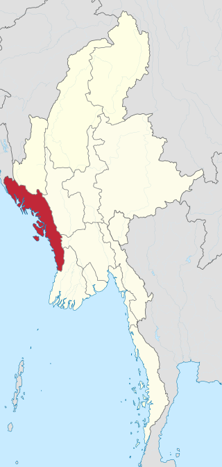
Rakhine State is a state in Myanmar (Burma). Situated on the western coast, it is bordered by Chin State to the north, Magway Region, Bago Region and Ayeyarwady Region to the east, the Bay of Bengal to the west and the Chittagong Division of Bangladesh to the northwest. It is located approximately between latitudes 17°30' north and 21°30' north and longitudes 92°10' east and 94°50' east. The Arakan Mountains or Rakhine Yoma separated Rakhine State from central Burma from North to South. Off the coast of Rakhine State there are some fairly large islands such as Ramree, Cheduba and Myingun. Rakhine State has an area of 36,762 square kilometres (14,194 sq mi) and its capital is Sittwe.

Myanmar is divided into twenty-one administrative subdivisions, which include 7 regions, 7 states, 1 union territory, 1 self-administered division, and 5 self-administered zones. Following is the table of government subdivisions and its organizational structure based on different regions, states, the union territory, the self-administered division, and the self-administered zones:

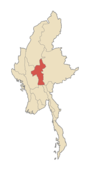
Mandalay Region is an administrative division of Myanmar. It is located in the center of the country, bordering Sagaing Region and Magway Region to the west, Shan State to the east, and Bago Region and Kayin State to the south. The regional capital is Mandalay. To the south of the region lies the national capital of Naypyidaw. The division consists of eleven districts, which are subdivided into 28 townships and 2,320 wards and village-tracts.

Pakokku is the largest city in the Magway Region of Myanmar. It is situated about 30 km northeast of Bagan on the Irrawaddy River. It is the administration seat of Pakokku Township, Pakokku District and Gangaw District. Pakokku Bridge is part of the India–Myanmar–Thailand Trilateral Highway and is the longest bridge in Myanmar. It is home of the Pakokku Airport.

Pyin Oo Lwin District is a district of the Mandalay Region in central Burma. It lies northeast of Mandalay, with the Myitnge River as its southern boundary. To the east it is bordered by Shan State and in part by the Chaung Magyi. It goes north as far as the town of Dakaung where it adjoins Htigyaing Township, Katha District in Sagaing Region. Its western boundary, is for the most part the Irrawaddy, but a very small portion of Thabeikkyin Township is west of the Irrawaddy, near the town of Baw in Sagaing Region. To the southwest it borders Mandalay District.

Singu is a township of Thabeikkyin District, Mandalay Division, Myanmar. The capital is Singu.
Yamethin Township is a township of Yamethin District in the Mandalay Region of Burma (Myanmar). The administrative seat and principal city is Yamethin, which is also the major rail stop in the township, and it has a population of 258,091.
Pyinmana Township is one of eight townships of Naypyidaw Union Territory, Myanmar.

Nyaungshwe Township is a township of Taunggyi District in Shan State, Myanmar. It is located south of Sakangyi and south-west of Taunggyi. The principal town is Nyaungshwe.

Daik-U Township is a township in Nyaunglebin District in the Bago Region of Burma. The principal town is Daik-U.
Gwebin is a village in Mogok Township, Pyin Oo Lwin District, in the Mandalay Region of central Burma. It is located 16 miles (26 km) west of Mogok. A track connects it to Shwenyaungbin and Mogok.
Ottarathiri Township is one of Naypyidaw Union Territory's eight townships, located south of Mandalay Region in Burma.
Pobbathiri Township is one of Naypyidaw Union Territory's eight townships, located south of Mandalay Region in Burma.
Zabuthiri Township is one of Naypyidaw Union Territory's eight townships, located south of Mandalay Region in Burma.
Zeyathiri Township is one of Naypyidaw Union Territory's eight townships, located south of Mandalay Region in Myanmar.
The Myanmar census 2014 was a nationwide census between 30 March and 10 April 2014 in Myanmar (Burma). 100,000 school teachers counted the population at midnight 29 March. The theme of the census campaign was A nationwide census – Let us all Participate.