
Mont-Terri Castle is a ruined medieval castle above a prehistoric hillfort on Mont Terri, located in the municipality of Cornol of the Canton of Jura in Switzerland. It is a Swiss heritage site of national significance. [1]
Mont-Terri Castle is a ruined medieval castle above a prehistoric hillfort on Mont Terri, located in the municipality of Cornol of the Canton of Jura in Switzerland. It is a Swiss heritage site of national significance. [1]
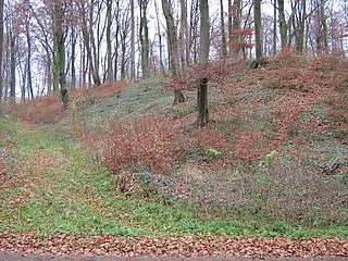
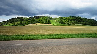
Mont Terri forms a buttress of the Lomont ridge (part of the Jura mountains), and is separated from it by a saddle called Derrière Mont Terri. The wooded summit forms a plateau four hectares (ten acres) in area. It is bounded on the west and southwest sides by steep cliffs, the remaining sides are protected by an ancient rampart. At the highest point of the plateau are the remains of a medieval fortified tower. [2]
The summit of Mont Terri is known locally as "Julius Caesar's Camp" (French language: Camp de Jules César); however, the earliest traces of habitation are from the Neolithic era. Pottery finds suggests that there was occupation during the Middle and Late Bronze Age. During the 1st century BC, a rampart was built of typical Gallic construction, a Murus Gallicus ; it has been associated with the Gallic Wars, but the only firm dating for the site is a later Roman coin from the reign of Augustus. There are also finds from a further period of occupation in the 4th century AD and other finds extend into the 10th century. [2] A stone tower was built on the site in the 13th century, probably replacing a previous wooden one, and is probably the "Château Thierry" mentioned in contemporary texts. [3]
The first investigation of the site was by an antiquarian and Jesuit priest, Father Pierre-Joseph Dunod, at the start of the 18th century. Writing in 1716, Father Dunod speculated that the site was the scene of a decisive battle between Caesar and the Suebi tribe led by Ariovistus. [4] There were later excavations by the owners of the site, Koeckler and Maupassant, who were found to have planted antiquities that they had purchased elsewhere, the deception being uncovered in 1862 by archaeologist Auguste Quiquerez (1801-1882). In the 20th century, methodical excavations by Alban Gerster (1898-1986) and in 1984 by a team from the University of Basle, have uncovered a range of finds from Neolithic flint arrow heads to a 10th-century dinarius coin from the reign of Louis IV of France. [2]

The Helvetii, anglicized as Helvetians, were a Celtic tribe or tribal confederation occupying most of the Swiss plateau at the time of their contact with the Roman Republic in the 1st century BC. According to Julius Caesar, the Helvetians were divided into four subgroups or pagi. Of these, Caesar names only the Verbigeni and the Tigurini, while Posidonius mentions the Tigurini and the Tougeni (Τωυγενοί). They feature prominently in the Commentaries on the Gallic War, with their failed migration attempt to southwestern Gaul serving as a catalyst for Caesar's conquest of Gaul.

The geography of Switzerland encompasses the geographical features of Switzerland, a mountainous and landlocked country located in Western and Central Europe. Switzerland's natural landscape is marked by its numerous lakes and mountains. It is surrounded by 5 countries: Austria and Liechtenstein to the east, France to the west, Italy to the south and Germany to the north. Switzerland has a maximum north–south length of 220 kilometres (140 mi) and an east–west length of about 350 kilometres (220 mi).

The Jura Mountains are a sub-alpine mountain range a short distance north of the Western Alps and mainly demarcate a long part of the French–Swiss border. While the Jura range proper is located in France and Switzerland, the range continues as the Table Jura northeastwards through northern Switzerland and Germany.
Vaud, more formally the canton of Vaud, is one of the 26 cantons forming the Swiss Confederation. It is composed of ten districts and its capital city is Lausanne. Its coat of arms bears the motto "Liberté et patrie" on a white-green bicolour.

Delémont is the capital of the Swiss canton of Jura. The city has approximately 12,000 inhabitants as of 2013.

Cadbury Castle is a Bronze and Iron Age hillfort in the civil parish of South Cadbury in the English county of Somerset. It is a scheduled monument and has been associated with King Arthur's legendary court at Camelot.

Bibracte, a Gallic oppidum, was the capital of the Aedui and one of the most important hillforts in Gaul. It was located near modern Autun in Burgundy, France. The material culture of the Aedui corresponded to the Late Iron Age La Tène culture.

Augusta Raurica is a Roman archaeological site and an open-air museum in Switzerland located on the south bank of the Rhine river about 20 km east of Basel near the villages of Augst and Kaiseraugst. It is the site of the oldest known Roman colony on the Rhine.

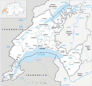
Cornol is a municipality in the district of Porrentruy in the canton of Jura in Switzerland.

Alesia was the capital of the Mandubii, one of the Gallic tribes allied with the Aedui. The Celtic oppidum was conquered by Julius Caesar during the Gallic Wars and afterwards became a Gallo-Roman town. Modern understanding of its location was controversial for a long time; however, it is now thought to have been located on Mont-Auxois, near Alise-Sainte-Reine in Burgundy, France.

Seeland is a region in Switzerland, at the south-eastern foot of the mountain range of the Jura Mountains containing the 3 Lakes of Morat, Neuchâtel, and Bienne (Biel). In previous eras, it was the floodplain of the Aare and was thus swampy. After the huge hydrological works Jura water correction, the area drained out and could support more cultivation. Seeland is one of the most important regions in Switzerland for growing vegetables, particularly in the Grand Marais.
Celtic Luxembourg existed during the period from roughly 600 BC until 100 AD, when the Celts inhabited what is now the territory of the Grand Duchy of Luxembourg. Their culture was well developed, especially from the 1st century BC, as can be seen from the remains of the extensive Titelberg site in the far southwest of the country and from the impressive finds in several tombs and necropolises in the Moselle valley and its surroundings.

Mont-Terrible was a department of the First French Republic, with its seat at Porrentruy.

The A16, a motorway in north-central Switzerland, is a divided freeway connecting the border to France to the A5 motorway, 84 kilometres (52 mi) to the south on the Swiss plateau.

The Tigurini were a clan or tribe forming one out of four pagi (provinces) of the Helvetii. The Tigurini were the most important group of the Helvetii, mentioned by both Julius Caesar and Poseidonius, settling in the area of what is now the Swiss canton of Vaud, corresponding to the bearers of the late La Tène culture in western Switzerland. Their name has a meaning of "lords, rulers". The other Helvetian tribes included the Verbigeni and the Tougeni, besides one tribe that has remained unnamed.


Mont Terri is one of the mountains of the Jura Mountains range. It is located south of Cornol in the Canton of Jura. The mountain can be located 140 km west of Zurich.

Archaeology is promoted in Jersey by the Société Jersiaise and by Jersey Heritage. Promotion in the Bailiwick of Guernsey being undertaken by La Société Guernesiaise, Guernsey Museums, the Alderney Society with World War II work also undertaken by Festung Guernsey.

The Burg Grenchen, also known as Bettleschloss, was a hill castle located above the present-day municipalities of Grenchen and Bettlach in the Canton of Solothurn, Switzerland. It is one of the early clearing castles in the Jura Mountains in Switzerland.
47°23′28″N7°09′40″E / 47.391222°N 7.161164°E
| | This article about a castle in Switzerland is a stub. You can help Wikipedia by expanding it. |