Montcalm, West Virginia

Last updated

Montcalm, West Virginia
Mercer County West Virginia incorporated and unincorporated areas Montcalm highlighted.svg
Location in Mercer County and the state of West Virginia.
Coordinates: 37°21′03″N81°14′48″W / 37.35083°N 81.24667°W / 37.35083; -81.24667
Country United States
State West Virginia
County Mercer
Area
[1]
  Total2.7 sq mi (7.1 km2)
  Land2.7 sq mi (7.1 km2)
  Water0.0 sq mi (0.0 km2)
Elevation
[2]
2,274 ft (693 m)
Population
 (2010) [3]
  Total726
  Density270/sq mi (100/km2)
Time zone UTC-5 (Eastern (EST))
  Summer (DST) UTC-4 (EDT)
ZIP code
24737
Area code 304
FIPS code 54-55372 [4]
GNIS feature ID2389496 [2]

Montcalm is a census-designated place (CDP) in Mercer County, West Virginia, United States. The population was 726 at the 2010 census. [3] It is part of the Bluefield, WV-VA micropolitan area which has a population of 107,342. Residents of Montcalm are called Montcalmers.

Contents

History

The first record of continuous European settlement of the Montcalm area is the 1840 census of Mercer County in what was then the state of Virginia. [5] A 700-acre farm, located where Crane Creek joins the Bluestone, was the property of George Bailey. He, his wife, and six children lived on the farm that included a farmhouse, likely located on the lower slopes of Tabernacle Mountain, an orchard and in what would be today's Main Street, and a field of timothy grass. About one hundred acres of corn field could be found at the top of a mountain on "the opposite side of the river" (either Methodist Church Hill or Browning Lambert Mountain). The farm also featured a small dam on the Crane Creek that powered a corn grist mill, the only one in the area and the farm's most valuable property. [6]

The Bailey family occupied this farm until 1852 when, in preparation for a move to the West, they sold their considerable estate and all of what would one day be the village of Montcalm for $1,500 to Robert Williams, a recently arrived retired sailor from the British Navy. [6]

Williams wrote and published his experiences in Mercer County and in the events that led up to the Civil War in Kansas in a memoir published in 1908 titled With the Border Ruffians, which is the earliest narrative of life in Montcalm's Bluestone Valley. [6]

Williams wrote about meeting the leaders of the early Mercer County communities, a court day in Princeton, a church camp meeting in what would one day be Glenwood Park, hunting in the hills around the Bluestone, community dances and several threats to his life while homesteading on the former Bailey Farm.

After several legal disputes in which he was largely not at fault, Williams sold the farm for $2,000 to the Herndon family, a slave-holding clan who owned a neighboring farm. According to West Virginia historian Kyle McCormick, descendants of the family lived in Montcalm a century later. [7]

According to local tradition, the name of the town that grew up around the former Bailey Farm was first identified as "Riverside". As it grew with the coming of first local coal mines and then railway lines, it was decided to place a local post office in the town circa 1910. It was then discovered that there was already a town in the state having a post office with the Riverside name and it was necessary to choose a new name. Undocumented tradition states that a group of local schoolchildren, when asked to help select a new town name, selected "Montcalm" as they had just completed their study of the French and Indian War, wherein Louis-Joseph de Montcalm had been the commander of the French forces in North America, and they liked the name.

In 1924 an enormous rainstorm resulted in the collapse of the mountainside along Crane Creek, causing a flash flood to inundate Montcalm and its neighboring town of McComas. An explosion of a mining ash and debris dump was touched off by the storm and began a mudslide that covered the train track in fifteen feet of mud and debris. Eight people were killed in what became known as the Catastrophe of Crane Creek. [8]

At some point in the 19th century the first formal school in the Montcalm area, known as the Mullins School, was established on Browning Lambert Mountain. [9]

Montcalm High School was founded as a junior high in 1931 and converted to a senior high in the 1950s. A new Montcalm High School was completed in 1983.

Notable people from Montcalm

Geography

Montcalm is located along the Bluestone River. The Bluestone River has been identified as having significant PCB contamination and high levels of fecal coliform bacteria.

According to the United States Census Bureau, the CDP has a total area of 2.7 square miles (7.1 km2), all land.

Climate

The climate in this area has mild differences between highs and lows, and there is adequate rainfall year-round. According to the Köppen Climate Classification system, Montcalm has a marine west coast climate, abbreviated "Cfb" on climate maps. [11]

Demographics

As of the census [4] of 2000, there were 885 people, 344 households, and 256 families residing in the CDP. The population density was 321.4 people per square mile (124.3/km2). There were 384 housing units at an average density of 139.4/sq mi (53.9/km2). The racial makeup of the CDP was 97.74% White, 0.56% African American, 0.79% Native American, 0.11% from other races, and 0.79% from two or more races. Hispanic or Latino of any race were 1.81% of the population.

There were 344 households, out of which 30.2% had children under the age of 18 living with them, 56.1% were married couples living together, 13.1% had a female householder with no husband present, and 25.3% were non-families. 22.1% of all households were made up of individuals, and 10.2% had someone living alone who was 65 years of age or older. The average household size was 2.57 and the average family size was 2.99.

In the CDP, the population was spread out, with 23.8% under the age of 18, 9.9% from 18 to 24, 27.3% from 25 to 44, 25.9% from 45 to 64, and 13.0% who were 65 years of age or older. The median age was 37 years. For every 100 females, there were 95.8 males. For every 100 females age 18 and over, there were 89.3 males.

The median income for a household in the CDP was $20,435, and the median income for a family was $21,630. Males had a median income of $28,750 versus $13,750 for females. The per capita income for the CDP was $9,671. About 19.3% of families and 24.3% of the population were below the poverty line, including 35.1% of those under age 18 and 12.0% of those age 65 or over.

Related Research Articles

<span class="mw-page-title-main">Summers County, West Virginia</span> County in West Virginia, United States

Summers County is a county located in the U.S. state of West Virginia. As of the 2020 census, the population was 11,959. Its county seat is Hinton. The county was created by an act of the West Virginia Legislature on February 27, 1871, from parts of Fayette, Greenbrier, Mercer and Monroe counties and named in honor of George W. Summers (1804–68).

<span class="mw-page-title-main">Mercer County, West Virginia</span> County in West Virginia, United States

Mercer County is a county in Southern West Virginia on the southeastern border of the U.S. state of West Virginia. At the 2020 census, the population was 59,664. Its county seat is Princeton. The county was originally established in the State of Virginia by act of its General Assembly on March 17, 1837, using lands taken from Giles and Tazewell counties.

<span class="mw-page-title-main">Graton, California</span> Census-designated place in California, United States

Graton is an unincorporated town and census-designated place (CDP) in west Sonoma County, California, United States. The population was 1,707 at the 2010 census. Graton's ZIP code is 95444. The town also has a culinary reputation attributed to two restaurants in the area.

<span class="mw-page-title-main">Palm City, Florida</span> Census-designated place in Florida, United States

Palm City is an unincorporated area and census-designated place (CDP) in Martin County, Florida, United States. The population was 25,883 at the 2020 census. It is part of the Port St. Lucie Metropolitan Statistical Area.

<span class="mw-page-title-main">High Ridge, Missouri</span> Census-designated place in Missouri, United States

High Ridge is an unincorporated community and census-designated place (CDP) in Jefferson County, Missouri, United States. The population was 4,305 at the 2010 census. At 927 feet (283 m) above sea level, High Ridge is the second-highest point in Jefferson County, second only to Sun Ridge, north of Hillsboro, according to data from the House Springs/Hillsboro 7.5 minute topographic quadrangles. The Beaumont Scout Reservation, a property of the Greater St. Louis Area Council, Boy Scouts of America, is 4 miles (6 km) north of High Ridge.

<span class="mw-page-title-main">Simms, Montana</span> CDP in Montana, United States

Simms is a census-designated place (CDP) in Cascade County, Montana, United States. The population was 354 at the 2010 census. It is part of the Great Falls, Montana Metropolitan Statistical Area.

<span class="mw-page-title-main">Canyon Lake, Texas</span> CDP in Texas, United States

Canyon Lake is a census-designated place (CDP) in Comal County, Texas, United States. The population was 31,124 at the 2020 census. It is part of the San Antonio Metropolitan Statistical Area.

<span class="mw-page-title-main">Bailey's Crossroads, Virginia</span> Census-designated place in Virginia, United States

Bailey's Crossroads is a census-designated place (CDP) in Fairfax County, Virginia, United States. The population was 24,749 at the 2020 census. Bailey's Crossroads lies at the crossroads of State Route 7 and State Route 244.

<span class="mw-page-title-main">Centreville, Virginia</span> Census-designated Place in Virginia, United States

Centreville is a census-designated place (CDP) in Fairfax County, Virginia, United States and a suburb of Washington, D.C. The population was 73,518 as of the 2020 census. Centreville is approximately 20 miles (32 km) west of Washington, D.C.

<span class="mw-page-title-main">Mount Vernon, Virginia</span> Census-designated place in Virginia, United States

Mount Vernon is a census-designated place (CDP) and unincorporated community in Fairfax County, Virginia, United States. The population was 12,914 at the 2020 census. Primarily due to its historical significance and natural recreation and beauty, the Mount Vernon area receives over one million tourists each year.

<span class="mw-page-title-main">Newington, Virginia</span> Census-designated place in Virginia, United States

Newington is a census-designated place (CDP) in Fairfax County, Virginia, United States. As of the 2020 census, the population was 13,223. The population was 12,943 at the 2010 census. The 2010 census showed a significant decrease after half the population was split off to the newly created Newington Forest CDP.

<span class="mw-page-title-main">West Springfield, Virginia</span> Census-designated place in Virginia, United States

West Springfield is a census-designated place (CDP) in Fairfax County, Virginia, United States. The population was 23,369 at the 2020 census.

<span class="mw-page-title-main">Tuckahoe, Virginia</span> Census-designated place in Virginia

Tuckahoe is a census-designated place (CDP) in Henrico County, Virginia, United States. It is an upper middle-class suburb to the west of Richmond. The population of Tuckahoe was 44,990 at the 2010 census. It is named after the area's history as the site of Thomas Randolph's Tuckahoe Plantation which still stands along the James River.

<span class="mw-page-title-main">Alum Creek, West Virginia</span> Census-designated place in West Virginia, United States

Alum Creek is a census-designated place (CDP) in Kanawha and Lincoln counties along the Coal River in the U.S. state of West Virginia. It includes the unincorporated communities of Alum Creek, Forks of Coal, and Priestley. The CDP had a population of 1,749 at the 2010 census, down from 1,839 at the 2000 census.

<span class="mw-page-title-main">Mount Gay-Shamrock, West Virginia</span> Census-designated place in West Virginia, United States

Mount Gay-Shamrock is a census-designated place (CDP) in Logan County, West Virginia, United States.

<span class="mw-page-title-main">Athens, West Virginia</span> Town in West Virginia, United States

Athens is a town in Mercer County, West Virginia, United States. The population was 944 at the 2020 census. It is part of the Bluefield, WV-VA micropolitan area which has a population of 107,578. Athens is the home of Concord University.

<span class="mw-page-title-main">Stanaford, West Virginia</span> Census-designated place in West Virginia, United States

Stanaford is a census-designated place (CDP) and coal town in Raleigh County, West Virginia, United States. The population was 1,350 at the 2010 census.

<span class="mw-page-title-main">Boaz, West Virginia</span> CDP in West Virginia, United States

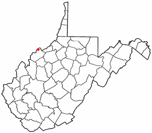
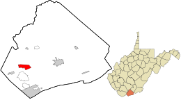
Boaz is a census-designated place (CDP) in Wood County, West Virginia, United States. It is part of the Parkersburg-Marietta-Vienna, WV-OH Metropolitan Statistical Area. As of the 2020 census, the CDP population was 1,321.

<span class="mw-page-title-main">Crane, Oregon</span> Unincorporated community in the state of Oregon, United States

Crane is a census-designated place and unincorporated community in Harney County, Oregon, United States, northeast of Malheur Lake on Oregon Route 78. Its population was 116 at the 2020 census.

<span class="mw-page-title-main">George Mason, Virginia</span> Census-designated place in Virginia, United States

George Mason is a census-designated place (CDP) in Fairfax County, Virginia, United States. The population at the 2020 census was 11,162. It consists of George Mason University and some adjacent neighborhoods to the south and southwest of the city of Fairfax, and is named for American Founding Father George Mason.

References

  1. "US Gazetteer files: 2010, 2000, and 1990". United States Census Bureau. February 12, 2011. Retrieved April 23, 2011.
  2. 1 2 U.S. Geological Survey Geographic Names Information System: Montcalm, West Virginia
  3. 1 2 "U.S. Census website". United States Census Bureau . Retrieved May 14, 2011.
  4. 1 2 "U.S. Census website". United States Census Bureau . Retrieved January 31, 2008.
  5. Schreiner-Yanits, Netti. 1840 Census of Mercer County Virginia. On file at the West Virginia University Library
  6. 1 2 3 Williams, Robert Hamilton (1907). With the Border Ruffians: Memories of the Far West, 1852-1868. ISBN   9780722283011.
  7. McCormick, K. The Story of Mercer County
  8. McCormick, K. The Story of Mercer County.
  9. "W.Va. Barn Demolition Uncovers 19th Century School", http://wvpublic.org/post/wva-barn-demolition-uncovers-19th-century-school
  10. Mother Anna and Other Unsettling Rumors. March 24, 2013.
  11. Climate Summary for Montcalm, West Virginia