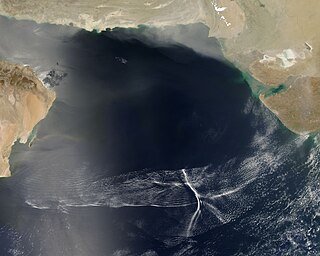
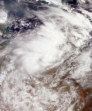
A Morning Glory cloud formation between Burketown and Normanton, Australia.The location of the Gulf of Carpentaria.Satellite photo of morning cloud formations over the Gulf of Carpentaria. Northern part of the visible linear cloud is North Australian Squall Line, Morning Glory cloud is the very southern part of this linear cloud.
The Morning Glory cloud is a rare meteorological phenomenon consisting of a low-level atmospheric solitary wave and associated cloud, occasionally observed in different locations around the world. The wave often occurs as an amplitude-ordered series of waves forming bands of roll clouds.
The southern part of the Gulf of Carpentaria in Northern Australia is the only known location where it can be predicted and observed regularly due to the configuration of land and sea in the area.
Description
Morning Glory clouds can be observed from Burketown from late September to early November. The town attracts glider pilots intent on riding this phenomenon.[1] There are generally only a handful of well formed spectacular clouds during this period at Burketown. During the 2012 season there were only four to be seen from there, but quite a few ragged unspectacular cloud lines were seen. Often they start to break up before arriving at Burketown or pass to the north and only stay well formed over water. In an aircraft there is a significantly better chance of sighting the cloud.
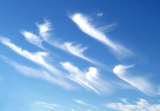
A Morning Glory cloud is a roll cloud, or arcus cloud, that can be up to 1,000 kilometres (620mi) long,[2]1 to 2 kilometres (0.62 to 1.24mi) high, often only 100 to 200 metres (330 to 660ft) above the ground. The cloud often travels at the rate of 10 to 20 metres per second.[3] Sometimes there is only one cloud, sometimes there are up to ten consecutive roll clouds.[4] Three distinct types of Morning Glory clouds have been identified.[3]
The Morning Glory is often accompanied by sudden wind squalls, intense low-level wind shear, a rapid increase in the vertical displacement of air parcels, and a sharp pressure jump at the surface.[5] Cloud is continuously formed at the leading edge while being eroded at the trailing edge.[4] Showers or thunderstorms may develop in its wake. In the front of the cloud, there is strong vertical motion that transports air up through the cloud and creates the rolling appearance, while the air in the middle and rear of the cloud becomes turbulent and sinks. The cloud quickly dissipates over land where the air is drier.[3]
The cloud can also be described as a solitary wave or a soliton or an undular bore, which is a wave that has a single crest and moves without changing speed or shape. They have been called "the biggest waves on the planet".[6] The wave may occur without the appearance of any clouds.[3]
The Morning Glory cloud of the Gulf of Carpentaria has been studied by multiple teams of scientists since the early 1970s. The first studies were published by Reg H. Clarke (University of Melbourne).[7] Multiple studies have followed since then, proposing diverse mathematical models explaining the complex movements of air masses in the region.
Atmospheric conditions
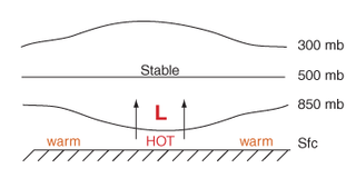
One of the main contributors for the formation of the morning glory clouds is the mesoscale circulations associated with a difference in sea breezes that develop over the Peninsula and the Gulf. On the large scale, Morning Glories are usually associated with frontal systems crossing central Australia and high pressure in northern Australia. Locals have noted that the Morning Glory is likely to occur when the humidity in the area is high, which provides moisture for the cloud to form, and when strong sea breezes have blown the preceding day.[8]
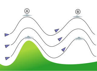
The following is a summary of the conditions that cause the Morning Glory cloud to form in the Gulf of Carpentaria (after hypothesis of R.H.Clarke, as described in 1981).[7] First, Cape York, which is the peninsula that lies to the east of the gulf, is large enough that sea breezes develop on both sides. During the day, the breeze from the Coral Sea coast blows in from the east and the breeze from the gulf blows in from the west. The two breezes meet in the middle of the peninsula, forcing the air to rise there and form a line of clouds over the spine of the peninsula. When night comes, the air cools and descends and at the same time a surface inversion (where air temperature increases with height) forms over the gulf. The densities in this stable layer are different above and below the inversion. The air descending from the peninsula to the east goes underneath the inversion layer and this generates a series of waves or rolling cylinders which travel across the gulf. These cylinders of air roll along the underside of the inversion layer, so that the air rises at the front of the wave and sinks at the rear. In the early morning, the air is saturated enough so that the rising air in the front produces a cloud, which forms the leading edge of the cylinder, and evaporates in the back, hence forming the Morning Glory cloud. The cloud lasts until the surface inversion disappears with the heating of the day.
There are other ways in which Morning Glory clouds form, especially in rarer cases in other parts of the world, but these are far less understood.[citation needed]
Local weather lore in the area suggests that when the fridges frost over and the café tables' corners curl upwards at the Burketown Pub, there is enough moisture in the air for the clouds to form. Reportedly, all winds cease at ground level as the cloud passes over.[9]
Other reported occurrences
Although the Morning Glory clouds over the southern part of the Gulf of Carpentaria are the most frequent and predictable, similar phenomena have occasionally been observed elsewhere, e.g., over central United States, in the English Channel, Munich,[4]Berlin, eastern Russia, and other maritime regions of Australia. There was one distinct and well formed roll cloud observed spanning from horizon to horizon (east to west), just prior to midnight on 22 October 2015 at 50.3044°N, 96.9692°W (about 35km North of Winnipeg, Manitoba, Canada), followed up by a series of them (but much less distinctive) shortly after midnight on 24 October 2015.[citation needed] There was another rare roll cloud formation that was observed in Masury, Ohio, 41.211168°N, -80.537849°W, on 27 May 2012, at 2:30 pm EST. This rare cloud event was observed by a mother and daughter, who also reported that high winds accompanied this formation, immediately after it being observed. Considering the rarity of the event in this region, it is seen as a once in a lifetime occurrence.[citation needed]
Morning Glory clouds have occasionally been reported on Cape Cod and in the Gulf of California off the Mexican coast. The phenomenon has also been observed from Sable Island, 180km southeast of Nova Scotia. A Morning Glory also passed through Yarmouth, Nova Scotia, in April 2009, as well as several communities in Newfoundland in May 2022. In contrast to the Gulf of Carpentaria where the Morning Glory is visible in the morning, those in the Maritimes have all occurred during the evening. Rare examples have been observed via satellite observation over the Joseph Bonaparte Gulf in the Eastern Kimberley region of Australia as well as over the Arabian Sea.[citation needed] A Morning Glory cloud was observed in 2007 over the Campos dos Goytacazes bay in the state of Rio de Janeiro, Brazil. In August 2011, it happened again over Peregrino Field in South Campos Basin in Brazil.[10] The phenomenon was also recorded on Batroun's shore (Lebanon– Middle East) in September 2004.[11] On 20 November 2013, a Morning Glory formation formed over the greater Durban area.[12][13] On 4 June 2015 a Morning Glory cloud formed over St. Cloud, FL, US. On 3 November 2016 a Morning Glory cloud formed over Appelscha, The Netherlands.[14] On 5 February 2018 a Morning Glory cloud formed over Richmond, Virginia, US. On 30 August 2018, a Morning Glory cloud formed over Ruskin, FL, US.[citation needed]
↑ Gavin Pretor-Pinney (2006). The Cloudspotter's Guide. Hodder & Stoughton. ISBN0-340-89589-6. Chapter 13, The Morning Glory the cloud that glider pilots surf, pp 283–305
Fog is a visible aerosol consisting of tiny water droplets or ice crystals suspended in the air at or near the Earth's surface. Fog can be considered a type of low-lying cloud usually resembling stratus, and is heavily influenced by nearby bodies of water, topography, and wind conditions. In turn, fog affects many human activities, such as shipping, travel, and warfare.
Wind shear, sometimes referred to as wind gradient, is a difference in wind speed and/or direction over a relatively short distance in the atmosphere. Atmospheric wind shear is normally described as either vertical or horizontal wind shear. Vertical wind shear is a change in wind speed or direction with a change in altitude. Horizontal wind shear is a change in wind speed with a change in lateral position for a given altitude.
A sea breeze or onshore breeze is any wind that blows from a large body of water toward or onto a landmass. By contrast, a land breeze or offshore breeze is any wind that blows from a landmass toward or onto a large body of water. The term offshore wind may refer to any wind over open water. Sea breezes and land breezes are both important factors in coastal regions' prevailing winds.
In meteorology, lee waves are atmospheric stationary waves. The most common form is mountain waves, which are atmospheric internal gravity waves. These were discovered in 1933 by two German glider pilots, Hans Deutschmann and Wolf Hirth, above the Giant Mountains. They are periodic changes of atmospheric pressure, temperature and orthometric height in a current of air caused by vertical displacement, for example orographic lift when the wind blows over a mountain or mountain range. They can also be caused by the surface wind blowing over an escarpment or plateau, or even by upper winds deflected over a thermal updraft or cloud street.
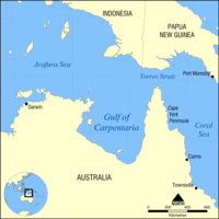
The Gulf of Carpentaria is a sea off the northern coast of Australia. It is enclosed on three sides by northern Australia and bounded on the north by the eastern Arafura Sea, which separates Australia and New Guinea. The northern boundary is generally defined as a line from Slade Point, Queensland in the northeast, to Cape Arnhem on the Gove Peninsula, Northern Territory in the west.
A waterspout is an intense columnar vortex that occurs over a body of water. Some are connected to a cumulus congestus cloud, some to a cumuliform cloud and some to a cumulonimbus cloud. In the common form, a waterspout is a non-supercell tornado over water having a five-part life cycle: formation of a dark spot on the water surface; spiral pattern on the water surface; formation of a spray ring; development of a visible condensation funnel; and ultimately, decay.
June Gloom is a mainly Southern California term for a weather pattern that results in cloudy, overcast skies with cool temperatures during the late spring and early summer. While it is most common in the month of June, it can occur in surrounding months, giving rise to other colloquialisms, such as “Graypril,” "May Gray," "No-Sky July," and "Fogust." Low-altitude stratus clouds form over the cool water of the California Current, and spread overnight into the coastal regions of California.
An arcus cloud is a low, horizontal cloud formation, usually appearing as an accessory cloud to a cumulonimbus. Roll clouds and shelf clouds are the two main types of arcus clouds. They most frequently form along the leading edge or gust fronts of thunderstorms; some of the most dramatic arcus formations mark the gust fronts of derecho-producing convective systems. Roll clouds may also arise in the absence of thunderstorms, forming along the shallow cold air currents of some sea breeze boundaries and cold fronts.
Burketown is an isolated outback town and coastal locality in the Shire of Burke, Queensland, Australia. In the 2016 census, the locality of Burketown had a population of 238 people.
The Shire of Burke is a local government area in North West Queensland, Australia. The shire lies on the south coast of the Gulf of Carpentaria and abuts the border with the Northern Territory. It covers an area of 39,864 square kilometres (15,391.6 sq mi), and has existed as a local government entity since 1885. The major town and administrative centre of the shire is Burketown.
In meteorology, an undular bore is a wave disturbance in the Earth's atmosphere and can be seen through unique cloud formations. They normally occur within an area of the atmosphere which is stable in the low levels after an outflow boundary or a cold front moves through.
The levant is an easterly wind that blows in the western Mediterranean Sea and southern France, an example of mountain-gap wind. In Roussillon it is called "llevant" and in Corsica "levante". In the western Mediterranean, particularly when the wind blows through the Strait of Gibraltar, it is called the Viento de Levante or the Levanter. It is also known as the Solano.
Thermal lows, or heat lows, are non-frontal low-pressure areas that occur over the continents in the subtropics during the warm season, as the result of intense heating when compared to their surrounding environments. Thermal lows occur near the Sonoran Desert, on the Mexican plateau, in California's Great Central Valley, in the Sahara, in the Kalahari, over north-west Argentina, in South America, over the Kimberley region of north-west Australia, over the Iberian peninsula, and over the Tibetan plateau.
Lift is a meteorological phenomenon used as an energy source by soaring aircraft and soaring birds. The most common human application of lift is in sport and recreation. The three air sports that use soaring flight are: gliding, hang gliding and paragliding.
The 1989–90 Australian region cyclone season was an above average tropical cyclone season. It was also an event in the ongoing cycle of tropical cyclone formation. It ran from 1 November 1989 to 30 April 1990. The regional tropical cyclone operational plan also defines a tropical cyclone year separately from a tropical cyclone season, and the "tropical cyclone year" ran from 1 July 1989 to 30 June 1990.
The 2012–13 Australian region cyclone season was a slightly below average tropical cyclone season event in the ongoing cycle of tropical cyclone formation. It officially started on 1 November 2012, and officially ended on 30 April 2013, despite Cyclone Zane being an active system at the time. The regional tropical cyclone operational plan defines a "tropical cyclone year" separately from a "tropical cyclone season"; the "tropical cyclone year" began on 1 July 2012 and ended on 30 June 2013.
Atmospheric optics is "the study of the optical characteristics of the atmosphere or products of atmospheric processes .... [including] temporal and spatial resolutions beyond those discernible with the naked eye". Meteorological optics is "that part of atmospheric optics concerned with the study of patterns observable with the naked eye". Nevertheless, the two terms are sometimes used interchangeably.
Tropical Low Fletcher was a weak system that produced torrential rains over parts of Queensland, Australia in February 2014. Originating as tropical low over the Timor Sea on 30 January, Fletcher quickly became an organised system as it moved over the Top End region of the Northern Territory. Once over the Gulf of Carpentaria on 2 February, deep convection formed near its center and the following day it became a tropical cyclone. With peak winds estimated at 65 km/h (40 mph), the storm made landfall in Queensland before weakening to a low. Over the following week, the system's movement became slow and erratic. Executing three loops, the former cyclone meandered over the southeastern Gulf of Carpentaria before accelerating southwest and later west. Fletcher was last noted on 12 February over the Alice Springs District in the Northern Territory.
This glossary of meteorology is a list of terms and concepts relevant to meteorology and atmospheric science, their sub-disciplines, and related fields.
Severe Tropical Cyclone Nora was a strong tropical cyclone that affected Far North Queensland and the northeastern Northern Territory during March 2018. The ninth named storm and third severe tropical cyclone of the 2017–18 Australian region cyclone season, Nora developed from a tropical low which formed near the Torres Strait on 19 March. The system initially moved quickly to the west-northwest, and then began tracking slowly southwestwards over the Arafura Sea while gradually developing. A turn to the east on 22 March brought the tropical low into a favourable environment for strengthening, and the system reached tropical cyclone intensity later that day. Nora then underwent a period of rapid intensification as it moved southeastwards into the Gulf of Carpentaria. The storm peaked on 23 March as a high-end Category 3 severe tropical cyclone with sustained winds of 155 km/h (96 mph) and a minimum barometric pressure of 958 hPa (28.29 inHg). Nora made landfall north of Pormpuraaw at about 13:00 UTC on 24 March as a minimal Category 3 system. Nora weakened steadily as it tracked southwards along the coast, and was downgraded to a tropical low the following day. Nora's remnants meandered over land for several days before moving back over the Gulf of Carpentaria and dissipating on 28 March.
This page is based on this Wikipedia article Text is available under the CC BY-SA 4.0 license; additional terms may apply. Images, videos and audio are available under their respective licenses.