
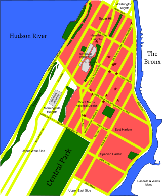
Harlem is a neighborhood in Upper Manhattan, New York City. It is bounded roughly by the Hudson River on the west; the Harlem River and 155th Street on the north; Fifth Avenue on the east; and Central Park North on the south. The greater Harlem area encompasses several other neighborhoods and extends west and north to 155th Street, east to the East River, and south to Martin Luther King Jr. Boulevard, Central Park, and East 96th Street.
Inwood is a neighborhood in the New York City borough of Manhattan, at the northern tip of Manhattan Island, in the U.S. state of New York. It is bounded by the Hudson River to the west, Spuyten Duyvil Creek and Marble Hill to the north, the Harlem River to the east, and Washington Heights to the south.

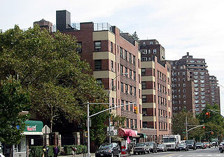
Morningside Heights is a neighborhood on the West Side of Upper Manhattan in New York City. It is bounded by Morningside Drive to the east, 125th Street to the north, 110th Street to the south, and Riverside Drive to the west. Morningside Heights borders Central Harlem and Morningside Park to the east, Manhattanville to the north, the Manhattan Valley section of the Upper West Side to the south, and Riverside Park to the west. Broadway is the neighborhood's main thoroughfare, running north–south.
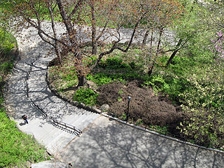
Morningside Park is a 30-acre (12-hectare) public park in Upper Manhattan, New York City. The park is bounded by 110th Street to the south, 123rd Street to the north, Morningside Avenue to the east, and Morningside Drive to the west. A cliff made of Manhattan schist runs through the park and separates Morningside Heights, above the cliff to the west, from Harlem. The park includes other rock outcroppings; a man-made ornamental pond and waterfall; three sculptures; several athletic fields; playgrounds; and an arboretum. Morningside Park is operated by the New York City Department of Parks and Recreation, although the group Friends of Morningside Park helps maintain it.
Upper Manhattan is the most northern region of the New York City borough of Manhattan. Its southern boundary has been variously defined, but some of the most common usages are 96th Street, the northern boundary of Central Park, 125th Street, or 155th Street. The term Uptown can refer to Upper Manhattan, but is often used more generally for neighborhoods above 59th Street; in the broader definition, Uptown encompasses Upper Manhattan.
Hamilton Heights is a neighborhood in the northern part of Manhattan in New York City. It is the northernmost part of the West Harlem area, along with Manhattanville and Morningside Heights to its south, and it contains the sub-neighborhood and historic district of Sugar Hill. Washington Heights lies to Hamilton Heights' north, and to its east is Central Harlem.

Manhattanville is a neighborhood in the New York City borough of Manhattan bordered on the north by 135th Street; on the south by 122nd and 125th Streets; on the west by Hudson River; and on the east by Adam Clayton Powell Jr. Boulevard and the campus of City College.

Sunnyside Gardens is a community within Sunnyside, a neighborhood in the New York City borough of Queens. The area was the first development in the United States patterned after the ideas of the garden city movement initiated in England in the first decades of the twentieth century by Ebenezer Howard and Raymond Unwin, specifically Hampstead Garden Suburb and Letchworth Garden City.

Sugar Hill is a National Historic District in the Harlem and Hamilton Heights neighborhoods of Manhattan, New York City, bounded by West 155th Street to the north, West 145th Street to the south, Edgecombe Avenue to the east, and Amsterdam Avenue to the west. The equivalent New York City Historic Districts are:

Marshall Heights is a residential neighborhood in Southeast Washington, D.C. It is bounded by East Capitol Street, Central Avenue SE, Southern Avenue, Fitch Street SE, and Benning Road SE. It was an undeveloped rural area occupied by extensive African American shanty towns, but the neighborhood received nationwide attention after a visit by First Lady Eleanor Roosevelt in 1934, which led to extensive infrastructure improvements and development for the first time. In the 1950s, Marshall Heights residents defeated national legislation designed to raze and redevelop the neighborhood. Queen Elizabeth II of the United Kingdom visited the area in 1991, at a time when Marshall Heights was in the throes of a violent crack cocaine epidemic. Limited redevelopment has occurred in the neighborhood, which was the site of two notorious child murders in 1973.
Public housing in Singapore is subsidised, built, and managed by the Government of Singapore. Starting in the 1930s, the country's first public housing was built by the Singapore Improvement Trust (SIT) in a similar fashion to contemporaneous British public housing projects, and housing for the resettlement of squatters was built from the late 1950s. In the 1960s under the SIT's successor, the Housing and Development Board (HDB), public housing consisting of small units with basic amenities was constructed as quickly and cheaply as possible at high densities and used for resettlement schemes. From the late 1960s, housing programmes focused more on quality, public housing was built in new towns, and a scheme allowing residents to lease their flats was introduced. Throughout the 1970s and 1980s, more public housing options were provided for the middle class and efforts to increase community cohesion within housing estates were made. From the 1990s, the government began portraying public housing as an asset, introducing large-scale upgrading schemes and loosening regulations on the resale of public housing while additional housing programmes for the sandwich classes and elderly residents were introduced. Rising housing prices led to public housing being seen as an investment from the 2000s, and new technologies and eco-friendly features were incorporated into housing estates.

Knickerbocker Village Limited is a housing development situated between the Manhattan Bridge and Brooklyn Bridge, in the Two Bridges section of the Lower East Side of Manhattan, New York City. Although the location was generally considered to fall in the Lower East Side, it has come to be thought of as part of Chinatown in recent years and the majority of residents are Chinese. It is located a short distance from New York City Hall, Civic Center, and the South Street Seaport. The complex consists of 1,590 apartments in twelve 13-story brick buildings surrounding two courtyards at 10-12-14-16-18-20 Monroe Street and 30-32-34-36-38-40 Monroe Street on the Lower East Side, taking up two whole city blocks and bounded by Catherine Street, Monroe Street, Market Street, and Cherry Street. Knickerbocker Village is in ZIP Code 10002.

The Boulevard Gardens Apartments is a 960-unit apartment complex at 54th Street and 31st Avenue in Woodside, Queens, New York City. It opened in June 1935, during the Great Depression. They were designed by architect Theodore H. Englehardt for the Cord Meyer Development Corporation; the design was based on an apartment complex Elgelhardt designed in Forest Hills.
The Hendrik Hudson, formally known as the Hendrik Hudson Residence Hotel, is a Tuscan-style apartment building located on Riverside Drive in Morningside Heights, Manhattan, New York City. The first plans for a building named for Hendrik Hudson on Riverside Drive were announced in October 1897 by Eugene Kirby, a former manager of the Marie Antoinette Hotel. This was to be an 18-story hotel. These plans were never completed, however, and by 1907, an apartment building bearing the name had been constructed instead.

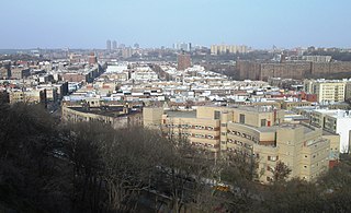
General Ulysses S. Grant Houses or Grant Houses is a public housing project at the northern boundary of Morningside Heights in the borough of Manhattan, New York City. The complex consists of 10 buildings with over 1,940 apartment units on 15.05-acres and is located between Broadway and Morningside Avenue, spanning oddly shaped superblocks from 123rd Street and La Salle Street to 125th Street. The development was named after Ulysses S. Grant (1822-1885), a Civil War Union army general and the 18th President of the United States.

Frederick Douglass Circle is a traffic circle located at the northwest corner of Central Park at the intersection of Eighth Avenue and 110th Street in the New York City borough of Manhattan. The traffic circle is named for the American abolitionist, women's suffragist, editor, orator, author, statesman, and reformer Frederick Douglass.
Carver Houses, or George Washington Carver Houses, is a public housing development built and maintained by the New York City Housing Authority (NYCHA) in Spanish Harlem, a neighborhood of Manhattan.


