Morrisburg, Ontario

Last updated

Morrisburg
Morrisburg mosbo6.jpg
Lakeshore Drive in Morrisburg
Stormont, Dundas and Glengarry locator map 2021.svg
Red pog.svg
Morrisburg
Canada Southern Ontario location map 2.png
Red pog.svg
Morrisburg
Coordinates: 44°53′50″N75°11′00″W / 44.89722°N 75.18333°W / 44.89722; -75.18333
Country Flag of Canada (Pantone).svg  Canada
Province Flag of Ontario.svg  Ontario
County Stormont, Dundas and Glengarry
Post office1851
Incorporated village1860
Area
  Total1.36 km2 (0.53 sq mi)
Population
 (2021)
  Total2,398
  Density1,759.5/km2 (4,557/sq mi)
Time zone UTC−05:00 (EST)
  Summer (DST) UTC−04:00 (EDT)
Postal Code FSA
K0C
Area codes 613

Morrisburg is an unincorporated community in the Municipality of South Dundas, located in Eastern Ontario, Canada. The population was 2,398 at the 2021 census. [1]

Contents

History

Upper Canada Village near Morrisburg Carlb-uppercanada-morrisburg-02.jpg
Upper Canada Village near Morrisburg

On November 11, 1813, a small British force repelled an invading American army at the Battle of Crysler's Farm, which took place near what was later to be called Morrisburg. [2] [3]

United Empire Loyalist settlers settled in Dundas County, creating West Williamsburg and was part of the Williamsburg Canal project. Between 1843 and 1856, canals were built on the north side of the St. Lawrence River. West Williamsburg was renamed Morrisburg in 1851, [4] in honour of Brockville, Ontario, politician James Morris, who was named the first Postmaster General of the United Province of Canada. [5] Incorporated as a village in 1860, Morrisburg had a growing manufacturing base consisting of a gristmill, a carding mill and a fanning mill. The Grand Trunk Railway reached Morrisburg in 1855. Eventually a power station was built on the St. Lawrence River. [6]

During the 1950s, portions of Morrisburg were relocated because of expected flooding caused by the St. Lawrence Seaway project. [7] [8] Over 80 homes were moved and the entire downtown business district was demolished and relocated to a shopping plaza. [9] The Canadian National Railway line was moved 1.1 kilometres (0.68 mi) north of its original location. [10] Much of the former railbed was used in the reconstruction of Ontario Highway 2. Buildings and other artifacts were moved and assembled to create Upper Canada Village, a tribute to the area's pioneers. [11]

A notable incident in the history of high-speed rail in Canada took place near Morrisburg in 1979, when a UAC TurboTrain operated by Via Rail on westbound service from Montréal to Toronto caught fire after developing an oil leak. The train was quickly evacuated and ultimately a third of it was destroyed in the fire. The troubled Turbo Trains were retired a few years later, in 1982. [12]

In 1997, Morrisburg was amalgamated with the Village of Iroquois, along with Matilda and Williamsburg Townships, into the Township of South Dundas.

Related Research Articles

<span class="mw-page-title-main">Battle of Crysler's Farm</span> War of 1812 battle

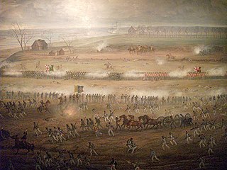
The Battle of Crysler's Farm, also known as the Battle of Crysler's Field, was fought on 11 November 1813, during the War of 1812. A British and Canadian force won a victory over a US force which greatly outnumbered them. The US defeat prompted them to abandon the St. Lawrence Campaign, their major strategic effort in the autumn of 1813.

<span class="mw-page-title-main">North Dundas, Ontario</span> Township in Ontario, Canada

North Dundas is a township in Eastern Ontario, Canada, in the United Counties of Stormont, Dundas and Glengarry.

Dundas County is a former county in the province of Ontario, Canada. It was named after Henry Dundas, 1st Viscount Melville, who was the British Home Secretary (1791–1794), with responsibility for the colonies.

<span class="mw-page-title-main">United Counties of Stormont, Dundas and Glengarry</span> County in Ontario, Canada

The United Counties of Stormont, Dundas and Glengarry (SDG) is an upper-tier municipality in the Canadian province of Ontario that comprises three historical counties and excludes the City of Cornwall and the Mohawk Nation of Akwesasne. However, both Cornwall and Akwesasne form part of a larger census division named for the United Counties of Stormont, Dundas and Glengarry. The municipality's administrative office is located within Cornwall.

<span class="mw-page-title-main">Lost Villages</span> Communities submerged by the Saint Lawrence Seaway

The Lost Villages were ten communities in the Canadian province of Ontario, in the former townships of Cornwall and Osnabruck near Cornwall, which were permanently submerged by the creation of the Saint Lawrence Seaway in 1958.

<span class="mw-page-title-main">Dickinson's Landing, Ontario</span> Underwater ghost town in Ontario, Canada

Dickinson's Landing is an underwater ghost town in the Canadian province of Ontario. It is one of Ontario's Lost Villages, which were permanently flooded by the creation of the St. Lawrence Seaway in 1958.

<span class="mw-page-title-main">Upper Canada Village</span> Living museum in Ontario, Canada.

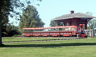
Upper Canada Village is a heritage park near Morrisburg, Ontario, which depicts a 19th-century village in Upper Canada.

<span class="mw-page-title-main">South Dundas</span> Municipality in Ontario, Canada

South Dundas is a municipality in eastern Ontario, Canada, in the United Counties of Stormont, Dundas and Glengarry along the north shore of the St. Lawrence River. It is located approximately 100 kilometres south of Ottawa and is midway between Kingston and Montreal, Quebec.

<span class="mw-page-title-main">Stormont, Dundas and Glengarry Highlanders</span> Military unit

Stormont, Dundas and Glengarry Highlanders is a Primary Reserve infantry regiment of the Canadian Army. It is part of 33 Canadian Brigade Group, 4th Canadian Division and is headquartered in Cornwall, Ontario.

The Long Sault Parkway is a group of eleven islands west of Cornwall in the Canadian province of Ontario, as well as the name of the 10.1-kilometre (6.3 mi) scenic parkway connecting them. The islands, which include two public beaches and three campgrounds, were created by the flooding of the Long Sault rapids during construction of the St. Lawrence Seaway. The parkway, the islands, and their amenities are maintained by the St. Lawrence Parks Commission.

<span class="mw-page-title-main">John Pliny Crysler</span> Canadian politician

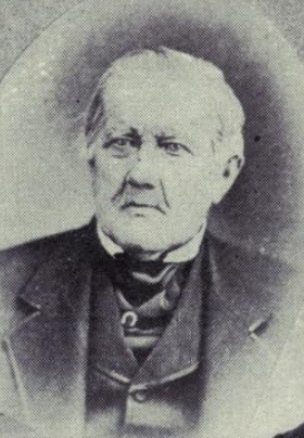
John Pliny Crysler was a timber merchant and political figure in Canada West.

John Crysler was a businessman and political figure in Upper Canada.

<span class="mw-page-title-main">James William Cook</span>

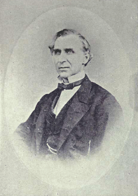
James William Cook was a lumber merchant and political figure in Canada West.

<span class="mw-page-title-main">John Cook (Upper Canada politician)</span> Merchant and politician in Upper Canada and Canada West

John Cook was a merchant and political figure in Upper Canada and Canada West.

King's Highway 31, commonly referred to as Highway 31 and historically known as the Metcalfe Road, was a provincially maintained highway in the Canadian province of Ontario. The 76.93-kilometre (47.80 mi) route connected Highway 2 in Morrisburg with the Chaudière Bridge at the Ontario–Quebec boundary in downtown Ottawa.

<span class="mw-page-title-main">Fort Wellington</span> Historic site in Ontario, Canada

Fort Wellington National Historic Site is a historic military fortification located on the north shore of the St. Lawrence River at Prescott, Ontario. The military fortification was used by the British Army, and the Canadian militia for most of the 19th century, and by the militia in the 20th century, until 1923, when the property was handed over to the Dominion Parks Commission, the predecessor to Parks Canada. The fort was earlier named a National Historic Site of Canada in January 1920.

<span class="mw-page-title-main">Chesterville, Ontario</span> Village in Ontario, Canada

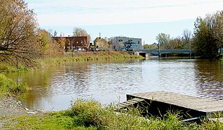
Chesterville is a village in the township of North Dundas, within the United Counties of Stormont, Dundas and Glengarry. It is located north of Morrisburg, west of Cornwall and south-east of Ottawa. The village is situated along the South Nation River.

<span class="mw-page-title-main">St. Lawrence Parks Commission</span>

The St. Lawrence Parks Commission is a Crown agency of the Government of Ontario that manages parks and heritage sites along the shoreline of the St. Lawrence River in southeastern Ontario. It functions similarly to the Niagara Parks Commission's role in overseeing attractions and conservation on the Ontario side of the Niagara River.

Henry Merkley (1756–1836) was a farmer and political figure in Upper Canada. He represented Dundas in the Legislative Assembly of Upper Canada from 1808 to 1812.

<span class="mw-page-title-main">Dundas County Militia</span> Regiment of the provincial militia of Upper Canada

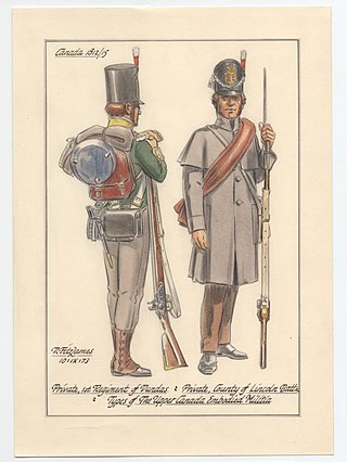
The Dundas County Militia was a regiment of the provincial militia of Upper Canada that was raised in Dundas County, Ontario, in the 1780s. The battle honours and legacy of the Dundas Militia are perpetuated by the Stormont, Dundas and Glengarry Highlanders.

References

  1. Government of Canada, Statistics Canada (February 9, 2022). "2021 Census of Population geographic summary: Morrisburg [Population centre], Ontario". www12.statcan.gc.ca. Retrieved December 5, 2023.
  2. "Battle of Crysler's Farm National Historic Site of Canada". The Canadian Encyclopedia. Archived from the original on November 8, 2013.
  3. Collins, Gilbert (2006). "Crysler's Farm Battlefield Park". Guidebook to the Historic Sites of the War of 1812 (2nd ed.). Dundurn Press. ISBN   978-1-55002-914-7.
  4. "Morrisburg". Lost Villages Historical Society. Retrieved April 11, 2024.
  5. Harkness, John Graham (1946). Stormont, Dundas and Glengarry, A History. Ottawa, Ontario: Mutual Press Limited. p. 285.
  6. "The Survivors – Morrisburg". The Lost Villages. Retrieved April 11, 2024.
  7. "Great Lakes-St. Lawrence Seaway System".[ dead link ]
  8. Kornwolf, James D. (2002). "Upper Canada Village". Architecture and Town Planning in Colonial North America. Vol. 1. JHU Press. ISBN   978-0-8018-5986-1.
  9. "Morrisburg-area men create online monument to history". Seaway News. July 4, 2012. Retrieved April 11, 2024.
  10. "NYC Ottawa Division - Significant Dates". New York Central Railroad. Archived from the original on July 7, 2007. Retrieved March 29, 2012.
  11. Mochoruk, Jim; Hinther, Rhonda (2011). Re-imagining Ukrainian Canadians: History, Politics, and Identity. University of Toronto Press. ISBN   978-1-4426-1062-0.
  12. Bateman, Chris (December 9, 2015). "Remembering the ill-fated CN Turbo train". Spacing Magazine. Retrieved May 30, 2021.

Further reading