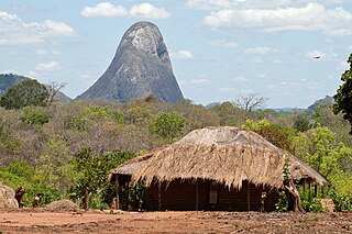
Nampula is a province of northern Mozambique. It has an area of 79,010 km2 (30,510 sq mi) and a population of 5,758,920, making it the most populous province in Mozambique. Nampula is the capital of the province.
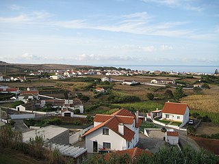
Vila do Porto is the single municipality, the name of the main town and one of the civil parishes on the island of Santa Maria, in the Portuguese archipelago of Azores. Its nearest neighbor, administratively, is the municipality of Povoação on the southern coast of São Miguel, and it is physically southwest of the islets of the Formigas. The population in 2021 was 5,408, in an area of 96.89 km2 (37.41 sq mi).
Nossa Senhora do Rosário is a civil parish and most populated area in the municipality of Lagoa, on the island of São Miguel, in the Portuguese archipelago of the Azores. With a population of 5396 inhabitants in 2011, the parish covers an area of approximately 6.52 square kilometres (2.52 sq mi) that extends from the southern coast of the island. It contains the localities Atalhada, Bairro das Socas, Nossa Senhora do Rosário, Porto dos Carneiros and Vila Mar.

Ajuda da Bretanha is a northern civil parish in the municipality of Ponta Delgada, on the island of São Miguel in the Portuguese archipelago of the Azores. It is a relatively new parish, being elevated to this status when the former parish of Bretanha was divided, forming Ajuda and Pilar da Bretanha. The population in 2011 was 661, in an area of 7.09 km². It contains the localities Ajuda da Bretanha, Amoreira and Lombinha.

Pilar da Bretanha is a civil parish in the municipality of Ponta Delgada on the island of São Miguel, in the Portuguese archipelago of the Azores. It was de-annexed from the historical parish of Bretanha on 10 July 2002, along with Ajuda da Bretanha. The population in 2011 was 624, in an area of 6.07 square kilometres (2.34 sq mi). It contains the localities Casa Telhada, Covas, João Bom and Pilar.

Lagoa is a municipality in the southwestern part of São Miguel Island in the Azores. The population in 2011 was 14,442, in an area of 45.59 km². Lagoa is located east of Ponta Delgada, the island capital.

Povoação is a municipality located in the southeastern corner of the island of São Miguel in the Portuguese archipelago of the Azores. The population in 2011 was 6,327, in an area of 106.41 km².

Almagreira is a civil parish in the municipality of Vila do Porto on the island of Santa Maria, in the Portuguese autonomous region of Azores. The population in 2011 was 599, in an area of 11.22 km². Bordering all other parishes of the island, it is located northwest of Vila do Porto.
Aljustrel is a town and a municipality in the Portuguese district of Beja. The population in 2011 was 9,257, in an area of 458.47 km2. The present mayor is Nelson Domingos Brito, elected by the Socialist Party. The municipal holiday is June 13.

Cartaxo is a municipality in the district of Santarém in continental Portugal. The population in 2011 was 24,462, in an area of 158.17 km2. The urbanized centre of Cartaxo had a population of 9,507 in 2001.
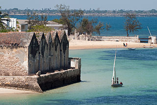
The Island of Mozambique lies off northern Mozambique, between the Mozambique Channel and Mossuril Bay, and is part of Nampula Province. Prior to 1898, it was the capital of colonial Portuguese East Africa. With its rich history and sandy beaches, the Island of Mozambique is a UNESCO World Heritage Site and one of Mozambique's fastest-growing tourist destinations. It has a permanent population of approximately 14,000 people and is served by nearby Lumbo Airport on the Nampula mainland. The name of the country, Mozambique, is derived from the name of this island.

Batalha is a town and a municipality in historical Beira Litoral province, and Leiria district in the Centro of Portugal. The town's name means "battle". The municipality population in 2011 was 15,805, in an area of 103.42 km2 (39.93 sq mi). The town proper has around 8,548 inhabitants in an area of 28.42 km2 (10.97 sq mi). The municipality is limited to the North and West by the municipality of Leiria, to the East by Ourém, to the Southeast by Alcanena and to the Southwest by Porto de Mós.

Igaci is a municipality in the Brazilian state of Alagoas. It has an area of 334.346 square kilometres . The climate is tropical savanna climate. As of 2020 the estimated population was 25,613.

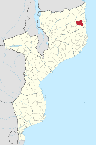
Angoche District is a district of Nampula Province in north-eastern Mozambique, with limits in the north with Mogincual District, in the south with Larde District, to the east with the Indian Ocean and to the west with Mogovolas District. The principal town is Angoche. It is located 185 km from the provincial capital, Nampula City.
Ancuabe District is a district of Cabo Delgado Province in northern Mozambique. It covers 4,984 km2 with 199,457 inhabitants in 2015. Its seat is the town of Ancuabe.
Nacala-a-Velha District is a district of Nampula Province in north-eastern Mozambique.

São Francisco do Conde is a municipality in the state of Bahia in the North-East region of Brazil. São Francisco do Conde covers 262.856 km2 (101.489 sq mi), and has a population of 40,245 with a population density of 150 inhabitants per square kilometer. It is located 67 kilometres (42 mi) from the state capital of Salvador. According to the Brazilian Institute of Geography and Statistics São Francisco do Conde has the highest concentration of Brazilians of African descent (90%) in Bahia.
A Bretanha was a former Portuguese civil parish in the municipality of Ponta Delgada, on the island of São Miguel in the archipelago of the Azores.
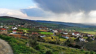
Tuizelo is a Portuguese freguesia (parish) of the municipality of Vinhais, Bragança district, with 34,80 km2 of area and 387 inhabitants (2011); it has a population density of only 11.1 inhabitants per square kilometer.
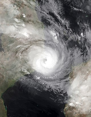
Tropical Cyclone Gombe was a strong tropical cyclone that affected Mozambique. It became the first storm to make a major landfall in Nampula Province in Mozambique since Cyclone Jokwe in 2008. The eighth tropical storm, fourth tropical cyclone and fourth intense tropical cyclone of the 2021–22 South-West Indian Ocean cyclone season, Gombe originated from a tropical disturbance located off the coast of Madagascar. This area of convection was designated by the Joint Typhoon Warning Center as Invest 97S on 6 March. The next day, it began to slowly move westward and executed a loop as it became more organized, which prompted Météo-France Reunion (MFR) to note the system as Zone of Disturbed Weather 09. The system became a depression on 9 March, and became a moderate tropical storm the same day. Soon after being named, Gombe made landfall in Madagascar, and entered in the Mozambique Channel the next day. The storm continued its westward motion while slowly intensifying, and was upgraded to a Tropical Cyclone by the MFR on 10 March. Closing in on Nampula Province, the storm underwent rapid intensification, and was upgraded to the fourth Intense Tropical Cyclone of the year and reached its peak intensity on 11 march, with maximum 10-minute sustained winds of 165 km/h (105 mph), maximum 1-minute sustained winds of 185 km/h (115 mph), and a minimum central pressure of 960 hectopascals (28 inHg). The storm proceeded to make landfall, and quickly lost its convection over land. On 12 March, Gombe degenerated into a remnant low overland. However, the system subsequently turned southeastward and reemerged over water, before briefly regenerating into a tropical depression on 17 March. Gombe dissipated later that day.