The Santa Cruz Mountains, part of the Pacific Coast Ranges, are a mountain range in central and northern California, United States. They form a ridge down the San Francisco Peninsula, south of San Francisco. They separate the Pacific Ocean from the San Francisco Bay and the Santa Clara Valley, and continue south to the Central Coast, bordering Monterey Bay and ending at the Salinas Valley. The range passes through the counties of San Mateo, Santa Clara, Santa Cruz, San Benito and Monterey, with the Pajaro River forming the southern boundary.

Mount Mitchell is the highest peak of the Appalachian Mountains and the highest peak in mainland eastern North America. It is located near Burnsville in Yancey County, North Carolina; in the Black Mountain subrange of the Appalachians, about 19 miles (31 km) northeast of Asheville. It is protected by Mount Mitchell State Park and surrounded by the Pisgah National Forest. Mount Mitchell's elevation is 6,684 feet (2,037 m) above sea level.

Doi Inthanon is the highest mountain in Thailand. It is in Chom Thong District, Chiang Mai Province. This mountain is an ultra prominent peak, known in the past as Doi Luang or Doi Ang Ga, meaning the 'crow's pond top'. Near the mountain's base was a pond where many crows gathered. The name Doi Inthanon was given in honour of Inthawichayanon, last King of Chiang Mai, who was concerned about the forests in the north and tried to preserve them. He ordered that after his death his remains be interred at Doi Luang, which was then renamed in his honour.

Mount Bartle Frere is the highest mountain in Queensland at an elevation of 1,611 metres (5,285 ft). The mountain was named after Sir Henry Bartle Frere, a British colonial administrator and then president of the Royal Geographical Society by George Elphinstone Dalrymple in 1873. Bartle Frere was British Governor of Cape Colony at the outset of the Zulu Wars. The Aboriginal name for the mountain is Chooreechillum.

The Siskiyou Mountains are a coastal subrange of the Klamath Mountains, and located in northwestern California and southwestern Oregon in the United States. They extend in an arc for approximately 100 miles (160 km) from east of Crescent City, California, northeast along the north side of the Klamath River into Josephine and Jackson counties in Oregon. The mountain range forms a barrier between the watersheds of the Klamath River to the south and the Rogue River to the north.

Mount Chirripó is the highest mountain in Costa Rica with an elevation of 3,821 meters. It is located in Chirripó National Park and is noted for its ecological wealth. The mountain was named "Chirripo," meaning "land of eternal waters", by Native Americans because there are many lakes and streams around the mountain. The high peaks in Chirripó National Park and La Amistad International Park host important areas of Talamancan montane forest and Costa Rican Páramo with high endemism and an extremely high biodiversity. The peaks of these mountains constitute sky islands for many species of plants and animals. Snow has not fallen on the peak in the past 100 years or so, according to the University of Costa Rica, but hail is sometimes reported.

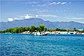
Manokwari is a coastal town and the capital of the Indonesian province of West Papua. It is one of only four provincial capitals of Indonesia without a city status. It is also the administrative seat of Manokwari Regency. Majority of Manokwari residents are Christians and the town is one of the seats of the Roman Catholic Diocese of Manokwari–Sorong.

Mount Pinos is a mountain located in the Los Padres National Forest on the boundary between Ventura and Kern counties in California. The summit, at 8,847 feet (2,697 m), is the highest point in Ventura County. The mountain is the highest point of the Transverse Ranges west of Tejon Pass, as well as the southernmost point of the Salinian Block.

Tatamailau, or Tata Mailau, sometimes referred as Mount Ramelau, is the highest mountain in East Timor and also of Timor island at 2,986 m (9,797 ft). The mountain is located approximately 70 km (43 mi) south of the capital Dili in the district of Ainaro. While East Timor was a Portuguese colony it was called the highest mountain of Portugal in the twentieth century, since the highest mountain of Portugal proper is of a more modest height. The name "Tatamailau" is Mambai-origin, the local language and means "Grandfather of all". "Ramelau" is the name of the massif of the mountain. The Tatamailau is dedicated to the Virgin Mary and the subject of an annual pilgrimage commemorating the Annunciation of the Blessed Virgin Mary, on or around 25 March. There is a three-metre-high statue of the Virgin Mary on the peak, which came from Italy and was erected during Indonesian occupation in 1997.

The Bird's Head Peninsula or Doberai Peninsula is a large peninsula that makes up the northwest portion of the island of New Guinea and the major part of the Province of West Papua, Indonesia. The other edge is on the Bird's Tail Peninsula.

The Sri Lanka montane rain forests is an ecoregion found above 1000 m in the central highlands of Sri Lanka. Owing to their rich biodiversity, this region considered a super-hotspot within the endemism hotspot of global importance. These forests are cooler than lowland forests and therefore they have ideal conditions for growth of cloud forests. Half of Sri Lanka's endemic flowering plants and 51 percent of the endemic vertebrates are restricted to these forests. More than 34 percent of Sri Lanka's endemic trees, shrubs, and herbs can only be found in this ecoregion. Twisted, stunted trees are a common sight in these forests, together with many varieties of orchids, mosses and ferns. The trees of montane rain forests grow to a height 10–15 meters, shorter than the lowland rain forest trees. These high altitude forests are the catchment area for most of Sri Lanka's major rivers.

The Arfak Mountains is a mountain range found on the Bird's Head Peninsula in the Province of West Papua, Indonesia.
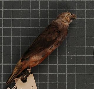
The grey-banded mannikin or grey-banded munia, is a species of estrildid finch is known to be found in Anggi Gigi, Tamrau Mountains and Arfak Mountains in the Vogelkop Peninsula in north-west Papua, Indonesia. This species inhabits at mid-mountain wet grassland and marshland. It also can be found at abandoned agricultural plots, near human settlements.
Phu Luang Wildlife Sanctuary is a wildlife sanctuary in northern Thailand, located in the Phu Luang mountain area, in the south of Loei Province. The area around the mountain is part of the Luang Prabang montane rain forests ecoregion.

The Pegunungan Arfak Nature Reserve lies in the north-east corner of the Bird's Head Peninsula in the Indonesian province of West Papua. It is located 25 km south of the provincial capital Manokwari. It spans from near the coast up to the highest point in the province, Pegunungan Arfak, at 2,955 m (9,695 ft).

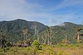
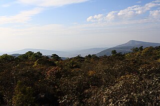
The Tamrau Mountains, also known as the Tambrauw Mountains or the Tamarau Mountains, is a mountain range located in the north central region of the Bird's Head Peninsula in the province of West Papua. It is made up of an isolated and lesser continuous mountain chain compared to the Arfak Mountains. The Tamrau and Arfak Mountains are both divided by the grassy Kebar Valley, which is the heartland of many indigenous people, with a variety of backgrounds. The Tamrau Mountains have been very scantily surveyed for any purpose till this day. The mountains are an important and threatened site of biodiversity, part of the Vogelkop montane rain forests ecoregion.

Bon Irau, with an elevation of 2,501 metres (8,205 ft), is the highest peak in the Tamrau Mountains and the highest point in the province of West Papua outside of the Arfak Mountains. It is located in the north central region of the Bird's Head Peninsula and located around 20 kilometres (12 mi) from the grassy Kebar Valley.

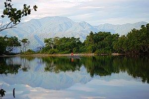
The Kebar Valley is a large pleistocene/holocene intermontane valley found in the north central region of the Bird's Head Peninsula in the province of West Papua. The valley is enclosed by the fault-bounded Tamrau Mountains at an area of 2,703 square kilometres (1,044 sq mi). Its depth averages from 500 to 600 m in the lower sections to around 900 to 1,400 m in the upper sections of the valley. The valley is located 130 km (81 mi) west of Manokwari and 190 km (120 mi) east of Sorong. The nearest major village to the valley is Saukorem. A notable path runs through the Kebar Valley connecting Saukorem to the settlement of Andai and reaches an altitude of 1,200 m (3,900 ft). This has created many villages throughout the area, leading to a growing rice production in the central and eastern regions of the valley. From north to south, the Kebar Valley ranges from 16 to 30 km wide, and from east to west, it extends from 94 to 116 km in length.
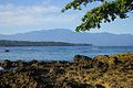
The Vogelkop-Aru lowland rain forests is a tropical moist forest ecoregion in Indonesia. The ecoregion covers the peninsular lowlands of western New Guinea, along with the Aru Islands and other nearby islands.
The Vogelkop montane rain forests is a tropical moist forest ecoregion in western New Guinea. The ecoregion covers the mountains of western New Guinea's Bird's Head and Bomberai peninsulas.