The South Western Ghats moist deciduous forests is an ecoregion in the Western Ghats of southern India with tropical and subtropical moist broadleaf forests. This biome covers the Nilgiri Hills between elevation of 250 and 1,000 m in Kerala, Karnataka and Tamil Nadu states.

The Arfak astrapia is a species of astrapia, a group of birds found in the birds-of-paradise family Paradiseidae.

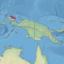
The Bird's Head Peninsula or Doberai Peninsula, is a large peninsula that makes up the northwest portion of the island of New Guinea, comprising the Indonesian provinces of Southwest Papua and West Papua. It is often referred to as The Vogelkop, and is so named because its shape looks like a bird's head on the island of New Guinea. The peninsula at the opposite end of the island is called the Bird's Tail Peninsula. The peninsula just to the south is called the Bomberai Peninsula.

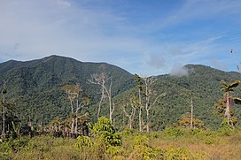
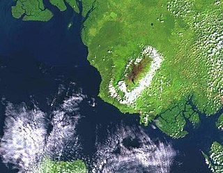
The Arfak Mountains is a mountain range found on the Bird's Head Peninsula in the Province of West Papua, Indonesia.

The New Guinea Highlands, also known as the Central Range or Central Cordillera, is a long chain of mountain ranges on the island of New Guinea, including the island's tallest peak, Puncak Jaya, Indonesia, 16,024 ft (4,884 m), the highest mountain in Oceania. The range is home to many intermountain river valleys, many of which support thriving agricultural communities. The highlands run generally east-west the length of the island, which is divided politically between Indonesia in the west and Papua New Guinea in the east.
The Mount Cameroon and Bioko montane forests is a tropical moist broadleaf forest ecoregion in central Africa. It occupies the upper slopes of coastal Mount Cameroon in Cameroon, and the mountains of nearby Bioko island in Equatorial Guinea.

The Central Range montane rain forests is a tropical moist forest ecoregion on the island of New Guinea. The ecoregion covers the Central Range of the New Guinea Highlands, which extends along the spine of the island. The montane rain forests of the ecoregion are distinct from the surrounding lowland forests, and are home to many endemic plants and animals.

The Central Range sub-alpine grasslands is a montane grasslands and shrublands ecoregion on the island of New Guinea. The ecoregion covers the highest-elevation portions of the New Guinea Highlands, which extend along the spine of the island. The high elevations support rare tropical sub-alpine and alpine habitats, including many endemic plants and animals.
The Huon Peninsula montane rain forests is a tropical moist forest ecoregion in New Guinea. The ecoregion covers the mountains of northeastern New Guinea's Huon Peninsula.

The Borneo montane rain forests is an ecoregion on the island of Borneo in Southeast Asia. It includes montane tropical and subtropical moist broadleaf forests, also known as a cloud forests. The ecoregion is partly in East Malaysia and Indonesia (Kalimantan).
The Pegunungan Arfak Nature Reserve lies in the north-east corner of the Bird's Head Peninsula in the Indonesian province of West Papua. It is located 25 km south of the provincial capital Manokwari. It spans from near the coast up to the highest point in the province, Pegunungan Arfak, at 2,955 m (9,695 ft).

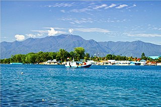
Mount Arfak is the highest point in the province of West Papua. It is located on north-east side of the Bird's Head Peninsula. It is a popular hiking area and is the highest peak of the Arfak Mountains. From the summit, Manokwari can be seen. The summit of Mt. Arfak is temperate and dry with very hot, dry summer temperatures that average below 95 °F (35 °C) and mild, humid winter temperatures that average above 38 °F (3 °C). During the winter months, the mountain's summit receives frost usually and sometimes can get to 33 °F (0 °C) every now and then. Sometimes snow can fall on the summit, but not every year. Average rain amount per year is about 45 inches (1150 mm). The mountain is part of the Pegunungan Arfak Nature Reserve, a 683-square-kilometer (264 sq mi) protected area that protects parts of the Vogelkop montane rain forests ecoregion. The mountain is also the highest point in the Manokwari metropolitan area.

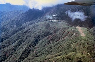
The Tamrau Mountains, also known as the Tambrauw Mountains or the Tamarau Mountains, is a mountain range located in the north central region of the Bird's Head Peninsula in the province of West Papua, Indonesia. It is made up of an isolated and lesser continuous mountain chain compared to the Arfak Mountains. The Tamrau and Arfak Mountains are both divided by the grassy Kebar Valley, which is the heartland of many indigenous people, with a variety of backgrounds. The Tamrau Mountains have been scantily surveyed. The mountains are an important and threatened site of biodiversity, part of the Vogelkop montane rain forests ecoregion.
Bon Irau, with an elevation of 2,501 metres (8,205 ft), is the highest peak in the Tamrau Mountains and the highest point in the province of West Papua outside of the Arfak Mountains. It is located in the north central region of the Bird's Head Peninsula and located around 20 kilometres (12 mi) from the grassy Kebar Valley.

The Vogelkop–Aru lowland rain forests is a tropical moist forest ecoregion in Indonesia. The ecoregion covers the peninsular lowlands of western New Guinea, along with the Aru Islands and other nearby islands.

The Northern New Guinea montane rain forests is a tropical moist forest ecoregion in northern New Guinea. The ecoregion covers several separate mountain ranges lying north of New Guinea's Central Range and south of the Pacific Ocean.

The Southeastern Papuan rain forests is a tropical moist forest ecoregion in southeastern New Guinea. The ecoregion covers the mountainous center and coastal lowlands of the Papuan Peninsula.

The Southern New Guinea freshwater swamp forests is a tropical moist forest ecoregion in southern New Guinea. The ecoregion includes the extensive swamp forests of southern and western New Guinea.
The Wandammen Peninsula, also known as the Wondiwoi or Wondiboy Peninsula, is a mountainous peninsula in western New Guinea. It extends northwards from the Bird's Neck Isthmus into Cenderawasih Bay. The Wandammen Mountains run north and south along the spine of the peninsula, rising from the shore up to 2,250 metres elevation, and extending southwards into the Bird's Neck Isthmus. The eastern slope of the mountains is steeper than the western slope. Roon Island lies off the north end of the peninsula.
The Kumawa Mountains are a mountain range in Western New Guinea. The Kumawa Mountains are a coastal range located on the southwestern Bomberai Peninsula. They are in West Papua Province in the Indonesian portion of New Guinea.