
A volcano is a rupture in the crust of a planetary-mass object, such as Earth, that allows hot lava, volcanic ash, and gases to escape from a magma chamber below the surface.

Vulcano or Vulcan is a small volcanic island belonging to Italy in the Tyrrhenian Sea, about 20 km (12 mi) north of Sicily and located at the southernmost end of the seven Aeolian Islands. The island is known for its volcanic activity and contains several volcanic calderas, including one of the four active volcanoes in Italy that are not submarine. The English word "volcano", and its equivalent in several European languages, derives from the name of this island, which derives from the Roman belief that the tiny island was the chimney of Vulcan, the Roman god of fire. In November 2021, 150 people were evacuated from the island's harbour area due to increased volcanic activity and gases; an amber alert had been issued in October 2021 after several significant changes in the volcano's parameters.

Volcanic cones are among the simplest volcanic landforms. They are built by ejecta from a volcanic vent, piling up around the vent in the shape of a cone with a central crater. Volcanic cones are of different types, depending upon the nature and size of the fragments ejected during the eruption. Types of volcanic cones include stratocones, spatter cones, tuff cones, and cinder cones.

The Mono–Inyo Craters are a volcanic chain of craters, domes and lava flows in Mono County, Eastern California. The chain stretches 25 miles (40 km) from the northwest shore of Mono Lake to the south of Mammoth Mountain. The Mono Lake Volcanic Field forms the northernmost part of the chain and consists of two volcanic islands in the lake and one cinder cone volcano on its northwest shore. Most of the Mono Craters, which make up the bulk of the northern part of the Mono–Inyo chain, are phreatic volcanoes that have since been either plugged or over-topped by rhyolite domes and lava flows. The Inyo volcanic chain form much of the southern part of the chain and consist of phreatic explosion pits, and rhyolitic lava flows and domes. The southernmost part of the chain consists of fumaroles and explosion pits on Mammoth Mountain and a set of cinder cones south of the mountain; the latter are called the Red Cones.

Belknap Crater is a shield volcano in the Cascade Range in the U.S. state of Oregon. Located in Linn County, it is associated with lava fields and numerous subfeatures including the Little Belknap and South Belknap volcanic cones. It lies north of McKenzie Pass and forms part of the Mount Washington Wilderness. Belknap is not forested and most of its lava flows are not vegetated, though there is some wildlife in the area around the volcano, as well as a number of tree molds formed by its eruptive activity.

The volcanism of Italy is due chiefly to the presence, a short distance to the south, of the boundary between the Eurasian Plate and the African Plate. Italy is a volcanically active country, containing the only active volcanoes in mainland Europe. The lava erupted by Italy's volcanoes is thought to result from the subduction and melting of one plate below another.
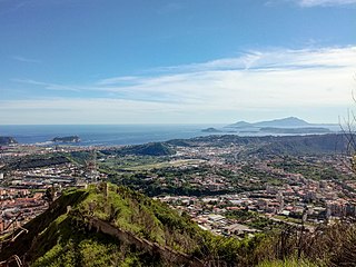
The Phlegraean Fields is a caldera volcano situated to the west of Naples, Italy. It is part of the Campanian volcanic arc, which includes Mount Vesuvius on the east side of Naples. The Phlegraean Fields is monitored by the Vesuvius Observatory. It was declared a regional park in 2003.

A maar is a broad, low-relief volcanic crater caused by a phreatomagmatic eruption. A maar characteristically fills with water to form a relatively shallow crater lake, which may also be called a maar.

An active volcano is a volcano that has erupted during the Holocene, is currently erupting, or has the potential to erupt in the future. A volcano that is not currently erupting but could erupt in the future is known as a dormant volcano. Volcanoes that will not erupt again are known as extinct volcanoes.
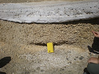
Phreatomagmatic eruptions are volcanic eruptions resulting from interaction between magma and water. They differ from exclusively magmatic eruptions and phreatic eruptions. Unlike phreatic eruptions, the products of phreatomagmatic eruptions contain juvenile (magmatic) clasts. It is common for a large explosive eruption to have magmatic and phreatomagmatic components.
Mount Leura is a 313-metre scoria cone surrounding a dry crater 100 m deep and is the central and most obvious component of a larger volcanic complex southeast of the town of Camperdown located in western Victoria, Australia, 194 kilometres (121 mi) south west of the state capital, Melbourne. The inactive volcano is thought to have last erupted between 5,000 and 20,000 years ago. The name means "big nose" in local aboriginal dialect.
Mount Porndon is a 278-metre-high (912 ft) Stratovolcano located 13 kilometres southeast of Camperdown in western Victoria, Australia.
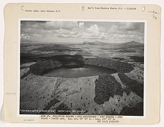
The Jolo Group of Volcanoes, more commonly referred to as the Jolo Group, are an active group of volcanoes in the island of Jolo in Southern Philippines. The Global Volcanism Program lists Jolo as one of the active volcanoes in the Philippines while the Philippine Institute of Volcanology and Seismology (PHIVOLCS) collectively list the group as Bud Dajo, one of the cinder cones on the island.

Vulsini, also known as Volsini volcano, Vulsini Volcanic District, Vulsini Volcanic Complex and the Vulsinian District, is a circular region of intrusive igneous rock in Lazio, Italy, about 87 km (54 mi) to the north northwest of Rome, containing a cluster of calderas known to have been active in recent geologic times. The Vulsinian region is one of dozens of intrusive circular regions, most smaller than the Vulsinian, arranged in a band from Campania through Lazio, called the Roman Comagmatic Province. A comagmatic province is a geologic area of the same type and age igneous rock deriving from the same crustal magma. The Roman region is post-collisional; that is, the intrusions were not a result of the lateral stresses that created Italy and raised the Apennines, but were subsequent to Italy's creation. The Volsinian is the northernmost region.

The Auckland Region of New Zealand is built on a basement of greywacke rocks that form many of the islands in the Hauraki Gulf, the Hunua Ranges, and land south of Port Waikato. The Waitākere Ranges in the west are the remains of a large andesitic volcano, and Great Barrier Island was formed by the northern end of the Coromandel Volcanic Zone. The Auckland isthmus and North Shore are composed of Waitemata sandstone and mudstone, and portions of the Northland Allochthon extend as far south as Albany. Little Barrier Island was formed by a relatively isolated andesitic volcano, active around 1 to 3 million years ago.

Waitomokia is a volcano in the Auckland volcanic field. Waitomokia's 600 m (2,000 ft) wide tuff crater contained three small scoria cones up to 20 m (66 ft) high, one with a crater, which were quarried in the 1950s.
Calabozos is a Holocene caldera in central Chile's Maule Region. Part of the Chilean Andes' volcanic segment, it is considered a member of the Southern Volcanic Zone (SVZ), one of the three distinct volcanic belts of South America. This most active section of the Andes runs along central Chile's western edge, and includes more than 70 of Chile's stratovolcanoes and volcanic fields. Calabozos lies in an extremely remote area of poorly glaciated mountains.

The Puhinui Craters are located in Auckland's Puhinui Reserve and are part of the Auckland volcanic field in the North Island of New Zealand. They were first recognised as volcanic craters in 2011. A cluster of three small maar craters like these is unique in the Auckland volcanic field. Their ages are unknown but most probably all three erupted during the same eruptive episode. They could have been associated with the eruption of nearby Matukutureia but this is speculation at present.

The Honolulu Volcanics are a group of volcanoes which form a volcanic field on the island of Oʻahu, Hawaiʻi, more specifically in that island's southeastern sector and in the city of Honolulu from Pearl Harbor to the Mokapu Peninsula. It is part of the rejuvenated stage of Hawaiian volcanic activity, which occurred after the main stage of volcanic activity that on Oʻahu built the Koʻolau volcano. These volcanoes formed through dominantly explosive eruptions and gave rise to cinder cones, lava flows, tuff cones and volcanic islands. Among these are well known landmarks such as Diamond Head and Punchbowl Crater.
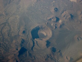
Lunar Crater volcanic field is a volcanic field in Nye County, Nevada. It lies along the Reveille and Pancake Ranges and consists of over 200 vents, mostly small volcanic cones with associated lava flows but also several maars, including one maar named Lunar Crater. Some vents have been eroded so heavily that the structures underneath the volcanoes have been exposed. Lunar Crater itself has been used as a testing ground for Mars rovers and as training ground for astronauts.


