In physical geography, a steppe is an ecoregion characterized by grassland plains without closed forests except near rivers and lakes. Steppe biomes may include:
The Global 200 is the list of ecoregions identified by the World Wide Fund for Nature (WWF), the global conservation organization, as priorities for conservation. According to WWF, an ecoregion is defined as a "relatively large unit of land or water containing a characteristic set of natural communities that share a large majority of their species dynamics, and environmental conditions". For example, based on their levels of endemism, Madagascar gets multiple listings, ancient Lake Baikal gets one, and the North American Great Lakes get none.

The Tian Shan, also known as the Tengri Tagh or Tengir-Too, meaning the "Mountains of God/Heaven", is a large system of mountain ranges in Central Asia. The highest peak in the Tian Shan is Jengish Chokusu, at 7,439 metres (24,406 ft) high. Its lowest point is the Turpan Depression, which is 154 m (505 ft) below sea level.

The Karakoram is a mountain range in the Kashmir region spanning the borders of Pakistan, China, and India, with the northwestern extremity of the range extending to Afghanistan and Tajikistan. Most of the Karakoram mountain range falls under the jurisdiction of Gilgit-Baltistan, which is administered by Pakistan. Its highest peak, K2, is located in Gilgit-Baltistan. It begins in the Wakhan Corridor (Afghanistan) in the west, encompasses the majority of Gilgit-Baltistan, and extends into Ladakh and Aksai Chin.
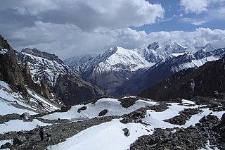
The Pamir Mountains are a mountain range between Central Asia and Pakistan. It is located at a junction with other notable mountains, namely the Tian Shan, Karakoram, Kunlun, Hindu Kush and the Himalaya mountain ranges. They are among the world's highest mountains.

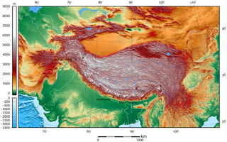
The Tibetan Plateau, also known as the Qinghai–Tibet Plateau or the Qing–Zang Plateau or as the Himalayan Plateau in India, is a vast elevated plateau located at the intersection of Central, South, and East Asia covering most of the Tibet Autonomous Region, most of Qinghai, western half of Sichuan, Southern Gansu provinces in Western China, southern Xinjiang, Bhutan, the Indian regions of Ladakh and Lahaul and Spiti as well as Gilgit-Baltistan in Pakistan, northwestern Nepal, eastern Tajikistan and southern Kyrgyzstan. It stretches approximately 1,000 kilometres (620 mi) north to south and 2,500 kilometres (1,600 mi) east to west. It is the world's highest and largest plateau above sea level, with an area of 2,500,000 square kilometres (970,000 sq mi). With an average elevation exceeding 4,500 metres (14,800 ft) and being surrounded by imposing mountain ranges that harbor the world's two highest summits, Mount Everest and K2, the Tibetan Plateau is often referred to as "the Roof of the World".

Montane ecosystems are found on the slopes of mountains. The alpine climate in these regions strongly affects the ecosystem because temperatures fall as elevation increases, causing the ecosystem to stratify. This stratification is a crucial factor in shaping plant community, biodiversity, metabolic processes and ecosystem dynamics for montane ecosystems. Dense montane forests are common at moderate elevations, due to moderate temperatures and high rainfall. At higher elevations, the climate is harsher, with lower temperatures and higher winds, preventing the growth of trees and causing the plant community to transition to montane grasslands and shrublands or alpine tundra. Due to the unique climate conditions of montane ecosystems, they contain increased numbers of endemic species. Montane ecosystems also exhibit variation in ecosystem services, which include carbon storage and water supply.

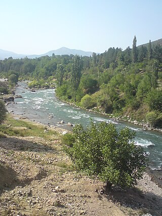
Bayanbulak Grassland National Nature Reserve is the second largest grassland in China, located in the Bayanbulak Basin of the Tian Shan mountains in northwest China. The terrain is mostly flat, and encompasses a middle section of the Kaidu River. The reserve is 200 km northwest of Korla in Bayingolin Mongol Autonomous Prefecture of Xinjiang Uyghur Autonomous Region.

Kolsay Lakes National Park is located on the north slope of the Tian Shan Mountains, southeast Kazakhstan. Often referred to as "Pearls of Tien Shan", the park's main feature are the Kolsay Lakes located between the Raiymbek District and Talgar District of Almaty Region. The scenic Lake Kaindy is also within the park. The park boundary is 120 kilometres (75 mi) southeast of Almaty. Lakes of landslide-tectonic origin, approximately formed in 1887 and 1911 on the Kaindy and Kolsay rivers.

Sayram-Ugam National Park, also Sairam-Ugam, is a mountainous region of the Western Tian Shan Mountains, on the border with Uzbekistan. Ugam-Chatkal National Park of Uzbekistan is across the border, and Aksu-Zhabagly Nature Reserve of Kazakhstan is directly to the northeast along the border. The area has high levels of species diversity, covering floral communities from steppe to high altitude zones. It is particularly known for stands of juniper forests, and stands of fruit and nut trees. Sayram-Ugam is located in Kazygurt District, Tole Bi District and Tulkibas District of South Kazakhstan Region. The park boundary is 30 kilometres (19 mi) southeast of the regional city of Shymkent, and 50 km northeast of the Uzbekh capital of Tashkent.

Zhongar-Alatau National Park, also Jungar Alatau, or Dzungurian Alatau, was created in 2010 to protect the unique ecology of the Dzungarian Alatau, an isolated, glaciated mountain range in Kazakhstan, on the southeastern border with China. One stated reason for creating the park is to protect forests of wild fruit trees, including apricots, barberry, cherries, and currants. Approximately 1% of the land area of the park is forested with Sievers Apple trees, which are the progenitors of all cultured apple varieties in the world. The park is 300 km long (west-to-east), and spreads across Aksu District, Sarkand District and Alakol District of Almaty Region, 300 km northeast of the regional city of Almaty.
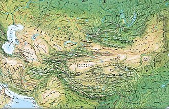
High-Mountain Asia (HMA) is a high-elevation geographic region in central-south Asia that includes numerous cordillera and highland systems around the Tibetan Plateau, encompassing regions of East, Southeast, Central and South Asia. The region was orogenically formed by the continental collision of the Indian Plate into the Eurasian Plate.

The Altai alpine meadow and tundra ecoregion is a terrestrial ecoregion covering the higher elevation of the Altai Mountains at the center of the "X" formed by the borders separating Russia, Kazakhstan, China, and Mongolia. The mountain peaks are the farthest north in Central Asia, separating the plains of Siberia to the north from the hot, dry deserts to the south. Altitudes above 2,400 meters display characteristics of tundra, with patches of alpine meadows and some trees immediately below the treeline. The ecoregion is in the montane grasslands and shrublands biome, and the Palearctic realm, with a humid continental climate. It covers an area of 90,132 square kilometres (34,800 sq mi).
The Tian Shan montane conifer forests ecoregion covers the "forest belt" of the Tian Shan mountains - generally the north-facing slopes that get enough moisture, and are warm enough, for trees to grow. This conifer belt is found mostly between 1,500 and 2,700 meters.

The Tian Shan montane steppe and meadows ecoregion covers a 2,000 km long stretch of grasslands of the isolated Tian Shan mountains of Central Asia. It is characterized by high-altitude flat and rolling grasslands.

The Pamir alpine desert and tundra ecoregion covers the high plateau of the Pamir Mountains, at the central meeting of the great mountain ranges of Central Asia: Himalaya, Karakoram, Hindu Kush, Kunlun, and Tian Shan. It is a region of relatively high biodiversity due to its central location and high elevation differentials, but it also acts as a barrier between the climate and habitats of north and south Asia.
The Gissaro-Alai open woodlands ecoregion covers the western foothills winding around two western offshoots of the Tian Shan Mountains in western Tajikistan, and parts of eastern Uzbekistan and western Kyrgyzstan, in Central Asia. The woodlands are typically of Juniper trees and shrubs, fitting the altitude zone situated between the desert valley floor, and the tree line, above which the mountain ridges are glaciated and barren.