Mtwara

Last updated
Mtwara
Mtwara-jour.JPG
The western shores of the Indian Ocean as seen from Mtwara.
Tanzania relief location map.svg
Red pog.svg
Mtwara
Location of Mtwara
Africa relief location map.jpg
Red pog.svg
Mtwara
Mtwara (Africa)
World location map (equirectangular 180).svg
Red pog.svg
Mtwara
Mtwara (Earth)
Coordinates: 10°16′25″S40°10′58″E / 10.27361°S 40.18278°E / -10.27361; 40.18278
CountryTanzania
Region Mtwara Region
Proclamation of the Region1971
Government
  Regional CommissionerHon. Col Ahmed Abbas Ahmed
  Regional Administrative SecretaryBahati I. Geuzye [1] [2]
Population
 (2022 census) [3]
  Total140,793
Time zone UTC+3 (EAT)
Website Town website

Mtwara (Portuguese: Montewara) is the capital city of Mtwara Region in southeastern Tanzania. In the 1940s, it was planned and constructed as the export facility for the disastrous Tanganyika groundnut scheme, but was somewhat neglected when the scheme was abandoned in 1951. The city is spread out over a large area planned to accommodate up to 200,000 people. The present population is around 141,000. As part of the development associated with the failed Tanganyika groundnut scheme, Mtwara features a deep-water port that can accommodate ocean-going vessels, and a range of large municipal buildings, including a post office. Recent improvements in the port made it possible for big container ships to berth there.

Contents

Transportation

Road

Mtwara has reasonable transport links considering its remoteness in southern Tanzania. It is linked by paved roads with Dar es Salaam and Lindi to the north and Masasi inland and by partially paved roads to Newala in-land to the west. Beyond Masasi the road is newly paved towards Songea via Tunduru and Namtumbo and the Unity Bridge which provides a crossing point to Mozambique.

Airport

The A19 links it with Mbamba Bay on Lake Malawi in the west. It features an airport with a new paved runway that can accommodate medium size passenger jets up to Boeing 737 and Airbus. Precision Air runs a daily morning flight between Mtwara Airport and Dar es Salaam and Air Tanzania offers a flight in the afternoon. The flight time is around an hour. Current improvement of the airport makes it possible for landing in the day and night or in the mist.

Bus

Mtwara serves as the access point for a small but growing tourism industry based in nearby Mikindani. New roads of a good standard were being built in 2013 within the city. Most of the roads have never been sealed. There is a choice of bus companies which provide daily services between Mtwara and Dar es Salaam. Also regular buses connect with Masasi, the biggest town inland from Mtwara.

Port

The port is the third largest ocean port in the country and was built as part of the failed Tanganyika groundnut scheme. The port was neglected for many years, however with the recent economic boom in the region, the government has spent funds for the upgrade of the port. Recently the port has seen added activity due to the construction of the Dangote cement factory and increased gas exploration activities and the recent energy crisis, has seen Mtwara port used as port for transporting Coal. The port in the future is planned to facilitate exports such as Cashew nuts, Iron, Coal and Gas. The port also has an Export Processing zone to facilitate the manufacturing industry in the area. New Port for dirty cargo such as Cement and Coal is planned to be constructed at Mgao Village near Mikindani, it is under final stage of procurement.

Economy

Iron ore and coal

Mtwara might be the port for the export of iron ore [4] and coal. There are plans to build a railway linking Mtwara with Lindi and mines at Mchuchuma and Liganga via Songea. [5]

In the year 2003, there were proposals for transporting coal from the Ludewa and Njombe regions respectively by rail to the port of Mtwara in Southern Tanzania as part of the Mtwara Development Corridor project. [6]

Cement

Mtwara hosts a branch of the Dangote Cement Public Limited Company and medium scale cement factory owned by Chinese at Mikindani called Lulu Cement.

Geography

Climate

Due to close proximity to the equator and the warm Indian Ocean, the city experiences tropical climatic conditions similar to all Tanzanian coastal cities. The city experiences hot and humid weather throughout much of the year and has a tropical wet and dry climate (Köppen: Aw). Annual rainfall is approximately 1,024 mm (40 in), and in a normal year the rainy season lasts from November to April/May and the dry season from then until late October. [7]

Climate data for Mtwara (1991-2020)
MonthJanFebMarAprMayJunJulAugSepOctNovDecYear
Record high °C (°F)34.4
(93.9)
35.0
(95.0)
36.1
(97.0)
33.9
(93.0)
32.8
(91.0)
32.2
(90.0)
33.3
(91.9)
33.3
(91.9)
35.0
(95.0)
36.1
(97.0)
36.1
(97.0)
34.1
(93.4)
36.1
(97.0)
Mean daily maximum °C (°F)30.7
(87.3)
30.8
(87.4)
31.1
(88.0)
30.9
(87.6)
30.3
(86.5)
29.5
(85.1)
29.4
(84.9)
29.8
(85.6)
30.0
(86.0)
31.5
(88.7)
31.3
(88.3)
30.5
(86.9)
30.1
(86.2)
Daily mean °C (°F)27.2
(81.0)
27.1
(80.8)
26.8
(80.2)
26.5
(79.7)
25.8
(78.4)
24.3
(75.7)
24.1
(75.4)
23.9
(75.0)
24.7
(76.5)
25.7
(78.3)
26.8
(80.2)
27.3
(81.1)
25.9
(78.5)
Mean daily minimum °C (°F)23.8
(74.8)
23.5
(74.3)
23.1
(73.6)
22.6
(72.7)
21.3
(70.3)
19.7
(67.5)
18.9
(66.0)
18.6
(65.5)
19.0
(66.2)
20.4
(68.7)
22.1
(71.8)
23.5
(74.3)
21.4
(70.5)
Record low °C (°F)20.6
(69.1)
20.2
(68.4)
21.1
(70.0)
19.4
(66.9)
15.0
(59.0)
13.9
(57.0)
15.0
(59.0)
15.0
(59.0)
16.0
(60.8)
17.2
(63.0)
18.3
(64.9)
19.9
(67.8)
13.9
(57.0)
Average precipitation mm (inches)183.2
(7.21)
180.9
(7.12)
237.5
(9.35)
160.6
(6.32)
54.0
(2.13)
10.5
(0.41)
7.7
(0.30)
10.1
(0.40)
12.9
(0.51)
28.9
(1.14)
52.0
(2.05)
143.3
(5.64)
1,081.6
(42.58)
Average precipitation days (≥ 1.0 mm)11.210.415.011.95.11.81.51.72.33.15.09.678.6
Average relative humidity (%)79848283707270717476767976
Mean monthly sunshine hours 229.4189.3217.0225.0263.5267.0266.6285.2270.0303.8297.0263.53,077.3
Mean daily sunshine hours 7.46.77.07.58.58.98.69.29.09.89.98.58.4
Source 1: NOAA [8]
Source 2: Deutscher Wetterdienst (extremes, humidity, and sun), [9] Tokyo Climate Center (mean temperatures 1991–2020) [10]

Sports

Football (Soccer)

Mtwara is the hometown of Bandari F.C. and NDANDA F. C.

Twin Town – Sister City

Mtwara is twinned with: [11]

See also

Related Research Articles

Transport in Tanzania includes road, rail, air and maritime networks. The road network is 86,472 kilometres (53,731 mi) long, of which 12,786 kilometres (7,945 mi) is classified as trunk road and 21,105 kilometres (13,114 mi) as regional road. The rail network consists of 3,682 kilometres (2,288 mi) of track. Commuter rail service is in Dar es Salaam only. There are 28 airports, with Julius Nyerere International being the largest and the busiest. Ferries connect Mainland Tanzania with the islands of Zanzibar. Several other ferries are active on the countries' rivers and lakes.

<span class="mw-page-title-main">Lindi</span> Historic town and regional capital of Lindi Region, southern Tanzania

Lindi is a historic southern Tanzanian coastal town and regional capital of the Lindi Region. The town is located at the far end of Lindi Bay on the Indian Ocean in southeastern Tanzania. The town is 450 kilometres (280 mi) south of Dar es Salaam and 105 km (65 mi) north of Mtwara, the southernmost coastal town in Tanzania, and gives its name to the surrounding Lindi Region. The Lindi Region is a large, yet sparsely populated, region of Tanzania.

<span class="mw-page-title-main">Mtwara Region</span> Region of Tanzania

Mtwara Region is one of Tanzania's 31 administrative regions. The regional capital is the municipality of Mtwara. Mtwara Region is home to one of the most infuluencial people in Tanzania, the Makonde. Mtwara is home to Tanzania's 4th president Benjamin Mkapa and is home to a number of influential artists. The boundary with Mozambique to the south is formed by the Ruvuma River. To the west, Mtwara is bordered by Ruvuma Region, to the north by Lindi Region, and to the east is the Indian Ocean.

<span class="mw-page-title-main">Songea</span> Capital of Ruvuma Region, Tanzania

Songea is the capital of Ruvuma Region in southwestern Tanzania. It is located along the A19 road. The city has a population of 286,285, and is the seat of the Roman Catholic Archdiocese of Songea. Between 1905 and 1907, the city was a centre of African resistance during the Maji Maji Rebellion in German East Africa. The city is poised to experience significant economic growth in the near future as the Mtwara Corridor opens up in a few years. It is projected to be the sixth fastest growing city on the African continent between 2020 and 2025, with a 5.74% growth.

<span class="mw-page-title-main">Mtwara District, Mtwara</span> District in Mtwara Region, Tanzania

Mtwara District is one of the five districts of the Mtwara Region of Tanzania. It is bordered to the south by Mozambique, to the west by the Tandahimba District, to the north by the Lindi Region and to the east by Mtwara-Mikindani District and the Indian Ocean.

<span class="mw-page-title-main">Catholic Church in Tanzania</span>

The Catholic Church in Tanzania is part of the worldwide Catholic Church, under the spiritual leadership of the Pope in Rome.

The Roman Catholic Archdiocese of Songea is the Metropolitan See for the ecclesiastical province of Songea in Tanzania.

The Roman Catholic Diocese of Tunduru–Masasi is a diocese located in Tunduru–Masasi in the ecclesiastical province of Songea in Tanzania.

<span class="mw-page-title-main">Outline of Tanzania</span> Overview of and topical guide to Tanzania

The following outline is provided as an overview of and topical guide to Tanzania:

<span class="mw-page-title-main">Railway stations in Tanzania</span>

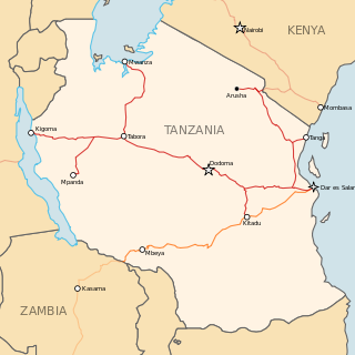
Railway stations in Tanzania include:

<span class="mw-page-title-main">Tanzania Ports Authority</span> Public corporation in Tanzania

Tanzania Ports Authority (TPA) is a parastatal public corporation acting under the aegis of the Ministry of Infrastructure Development, that has the responsibility "to manage and operate" the ocean ports and lake ports of the country of Tanzania. The Tanzania Ports Authrorty headquarters are located in Mchafukoge ward of Ilala District in Dar es Salaam Region. It is a member of the Port Management Association of Eastern and Southern Africa.

<span class="mw-page-title-main">Mtwara–Mbamba Bay Road</span> Road in Tanzania

The Mtwara–Mbamba Bay Road, also called the A19 Road, connects the city of Mtwara on the Indian Ocean coast, to the town of Mbamba Bay on the eastern coast of Lake Malawi. It is a busy and important transport corridor in the southern regions of Tanzania. It is also an integral part of the Mtwara Development Corridor that spans four Southern African countries; Malawi, Mozambique, Tanzania and Zambia.

The Southern Province Railway was a 1,000 mm narrow gauge rail network in Tanzania, which was operated only for a few years in the middle of the 20th Century. It ultimately comprised about 275 route kilometers. The central line of the railway network was Mtwara - Nachingwea. The isolated network operated without connection to the national network. Because of the failure of the Tanganyika Groundnut Scheme the rail system was deprived of its economic existence. After the independence of Tanzania, operations were ceased in February 1963 and the line was abandoned.

Dangote Industries Tanzania Thermal Power Station, is a 45 megawatts (60,000 hp), natural-gas powered thermal power plant in Tanzania, the second-largest economy in the East African Community. Originally, the power station was planned to be a 75 megawatts (101,000 hp), coal-fired power station.

<span class="mw-page-title-main">Mtwara Development Corridor</span>

The Mtwara Development Project is a major infrastructure development project involving southern Tanzania, northern Mozambique, eastern Malawi and Eastern Zambia. The goal of this project is to provide road, rail and waterway access from the surrounding region to the Port of Mtwara. The region and the corridor has been neglected by the respective governments for over 40 years and the recent discovery of oil, gas and various minerals has kick started the development of the project. A road and rail link is to be built from the port of Mtwara to Mbamba Bay on Lake Nyasa to link Malawi to the corridor and further road links into Mozambique will facilitate access to northern Mozambique.

<span class="mw-page-title-main">Cashew production in Tanzania</span>

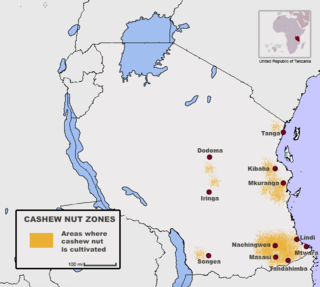
Tanzania is one of the largest cashew producers in Africa, with exports providing 10-15 percent of the country's foreign exchange. The country is the eighth-largest grower of cashew nut in the world and ranks fourth in Africa. The country provides 20% of Africa's cashew nut and only trails in production of Nigeria, Cote D'Ivoire, and Guinea-Bissau, according to figures released in 2012 by United Nations Food and Agricultural Organisation (FAO). The country has been engaged in the production of the cash crop since before independence in the years 1960s however, poor regulation and lack of reliable payments to farmers have posed significant challenges to the Cashew Nut farming industry in Tanzania. Guinea-Bissau, a country a tenth of the area of Tanzania's, has a significantly greater yield.

The Tanzanian Broadcasting Corporation is a television network. It is Tanzania's national network and is government-owned and operated.

<span class="mw-page-title-main">Mtwara-Mikindani District, Mtwara</span> District of Mtwara Region, Tanzania

Mtwara Mikindani Municipal District Council is one of eight regional councils of the Mtwara Region in Tanzania. It is bordered to the north by the Lindi Region, to the east by the Indian Ocean and to the south and west by the Mtwara District. In 2016, the municipality has a total population of 113,732.

References

  1. "JPM makes extensive RCs, DCs, civil service postings". www.ippmedia.com.
  2. "JPM makes extensive RCS, DCS, civil service postings".
  3. Citypopulation.de Population of cities & urban localities in Tanzania
  4. "Iron & Steel". National Development Corporation. Archived from the original on 25 December 2008.
  5. "Tazara hopes rise on investment plan". Railway Gazette. 2008-11-01. Retrieved 2011-02-08.
  6. RailwaysAfrica
  7. "Climate Mtwara". meteoblue. Retrieved 2016-01-06.
  8. "Mtwara Climate Normals 1991–2020". World Meteorological Organization Climatological Standard Normals (1991–2020). National Oceanic and Atmospheric Administration. Archived from the original on 16 September 2023. Retrieved 16 September 2023.
  9. "Klimatafel von Mtwara / Tansania" (PDF). Baseline climate means (1961-1990) from stations all over the world (in German). Deutscher Wetterdienst. Retrieved 10 June 2016.
  10. "Normals Data: Mtwara - Tanzania Latitude: 10.27°N Longitude: 40.18°E Height: 113 (m)". Japan Meteorological Agency. Retrieved 1 December 2022.
  11. "Twinning". redditchbc.gov.uk. Redditch Borough Council. Retrieved 2020-11-04.

10°16′25″S40°10′58″E / 10.27361°S 40.18278°E / -10.27361; 40.18278