Municipal road (Italy)

Last updated
Corso Buenos Aires in Milan, an urban strada comunale classified as strada locale. Corso Buenos Aires in Milan.jpg
Corso Buenos Aires in Milan, an urban strada comunale classified as strada locale.

A strada comunale (Italian for municipal road; pl. "strade comunali"), abbreviated SC, is an Italian road that is maintained by comune , hence the name. They can be roads owned by comune (inside population centers) or roads managed by the comune (outside population centers). A municipal road is less important than a provincial road.

Contents

Description

Via Cristoforo Colombo at Porta Ardeatina in Rome, an urban strada comunale classified as strada urbana di scorrimento. Rom 2011-08-by-RaBoe-13.jpg
Via Cristoforo Colombo at Porta Ardeatina in Rome, an urban strada comunale classified as strada urbana di scorrimento.
Extra-urban strada comunale in Veneto region marked with a number and with the abbreviation SC. Very rarely extra-urban strade comunali are marked with a number and with the abbreviation SC. Strada comunale - strada locale italiane extraurbana - categoria F per il codice della strada.JPG
Extra-urban strada comunale in Veneto region marked with a number and with the abbreviation SC. Very rarely extra-urban strade comunali are marked with a number and with the abbreviation SC.

The category of strade comunali includes extra-urban roads considered to be of municipal importance, all urban roads as well as the urban sections of state, regional or provincial roads, which pass through centers with 10,000 or more inhabitants. The urban sections of state, regional or provincial roads that pass through towns with fewer than 10,000 inhabitants are not municipal. [4]

Strade comunali within inhabited centers can be classified from a construction-technical point of view either as urban roads (type D and E) or as local roads (type F). Extra-urban municipal roads (outside inhabited centers) can be technically classified as strade extraurbane principali (type B; "main extra-urban roads"), strade extraurbane secondarie (type C; "secondary extra-urban roads"), strade urbane di scorrimento (type D; "urban traffic roads") or strada locale (type F; local roads). [5]

Assuming that the urban roads within the inhabited centers are all owned by the municipality (with the exception of the internal sections of state, regional or provincial roads that pass through inhabited centers with a population not exceeding 10,000 inhabitants), it is understood that the extra-urban roads outside the inhabited centers are to be considered municipal when: [4] [6]

The useful elements to assume that a road is municipal property are: its location within the inhabited centres, its name in the toponymy and consequently in the cadastral maps, its house numbering, presence of lighting and water collection, be constantly maintained by the municipal body.

Nomenclature

Ok street sign nome-strada roma.JPG
Piazza Duomo Milan Sign.jpg
Road signs for a strada comunale within an inhabited center
Italian traffic signs - strada comunale 2.svg
Road sign for extra-urban strade comunali in use since 1992
Segnale stradale italiano 1979 - numero strada comunale esterna (esempio fig 202).svg
Road sign for extra-urban strade comunali in use from 1979 to 1992
Fig. 102d - Segnale di identificazione di strade comunali - 1959.svg
Road sign for extra-urban strade comunali in use until 1979

The municipal roads within the inhabited centers are named as via, viale, corso, piazza, piazzetta, etc. followed by a name (for example via Adige). The names of municipal roads within inhabited centers are shown on rectangles, standardized by the Italian Highway Code, with a white background (except for local specificities, such as the Venetian nizioleti).

Extra-urban strade comunali may be identified by a number. In road signs and maps the number is preceded by the acronym SC, an acronym for strada comunale ("municipal road"). In road signs the alphanumeric acronym is enclosed in a white rectangle with a black acronym. Very rarely extra-urban strade comunali are marked with a number and with the abbreviation SC. [3]

See also

Other Italian roads

Related Research Articles

<span class="mw-page-title-main">Transport in Italy</span> Overview of the transport in Italy

Italy has a well developed transport infrastructure. The Italian rail network is extensive, especially in the north, and it includes a high-speed rail network that joins the major cities of Italy from Naples through northern cities such as Milan and Turin. The Florence–Rome high-speed railway was the first high-speed line opened in Europe when more than half of it opened in 1977. Italy has 2,507 people and 12.46 km2 per kilometer of rail track, giving Italy the world's 13th largest rail network. The Italian rail network is operated by state-owned Ferrovie dello Stato, while the rail tracks and infrastructure are managed by Rete Ferroviaria Italiana.

<span class="mw-page-title-main">State highway</span> Highway owned by the state, either a reference to the national government or a specific state

A state highway, state road, or state route is usually a road that is either numbered or maintained by a sub-national state or province. A road numbered by a state or province falls below numbered national highways in the hierarchy.

<i>Comune</i> Third-level administrative division of Italy

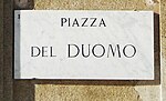
A comune is an administrative division of Italy, roughly equivalent to a township or municipality. It is the third-level administrative division of Italy, after regions and provinces. The comune can also have the title of città.

<span class="mw-page-title-main">Moderates (Italy)</span> Political party in Italy

The Moderates are a centrist political party in Italy, active mainly in Piedmont, but also in Lombardy, Emilia-Romagna, Campania and Sicily. The party, whose leader is Giacomo Portas, is associated with the centrist party Italia Viva.

<span class="mw-page-title-main">Borgosatollo</span> Comune in Lombardy, Italy

Borgosatollo is a comune in the province of Brescia, in Lombardy, Italy. It is bounded by other communes of Brescia, Castenedolo, Montirone, Poncarale and San Zeno Naviglio, and situated directly south of Brescia, in the plain.
Borgosatollo's area include also two frazioni, Gerole and Piffione.

A routenumber, designation or abbreviation is an identifying numeric designation assigned by a highway authority to a particular stretch of roadway to distinguish it from other routes and, in many cases, also to indicate its classification, general geographical location and/or orientation. The numbers chosen may be used solely for internal administrative purposes; however, in most cases they are also displayed on roadside signage and indicated on maps.

<span class="mw-page-title-main">Province of Caltanissetta</span> Province of Italy

The province of Caltanissetta is a province in the southern part of Sicily, Italy. Following the suppression of the Sicilian provinces, it was replaced in 2015 by the free municipal consortium of Caltanissetta. The province contains 22 comuni. Its coat of arms is a red crest and two green leaf stems on top with a laurel leaf on the right and a crown in the middle. The River Salso is the main river of the province; it is 122 kilometres (76 mi) long and originates in the province of Palermo, and it flows into the Mediterranean in this province at the end of the Gulf of Gela.

<span class="mw-page-title-main">Road hierarchy</span> Hierarchy in road traffic

The road hierarchy categorizes roads according to their functions and capacities. While sources differ on the exact nomenclature, the basic hierarchy comprises freeways, arterials, collectors, and local roads. Generally, the functional hierarchy can more or less correspond to the hierarchy of roads by their owner or administrator.

<span class="mw-page-title-main">Province of Trapani</span> Province of Italy

The province of Trapani is a province in the autonomous island region of Sicily, Italy. Following the suppression of the Sicilian provinces, it was replaced in 2015 by the free municipal consortium of Trapani. Its capital is the city of Trapani. It has an area of 2,469.62 square kilometres (953.53 sq mi) and a total population of 433,826 (2017). There are 25 comuni in the province.

<span class="mw-page-title-main">Autostrade of Italy</span> National motorway system of Italy

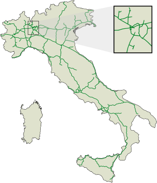
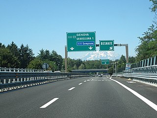
The autostrade are roads forming the Italian national system of motorways. The total length of the system is about 7,016 kilometres (4,360 mi), as of 30 July 2022. To these data are added 13 motorway spur routes, which extend for 355 kilometres (221 mi).

<span class="mw-page-title-main">Mayor of Milan</span>

The mayor of Milan is the first citizen and head of the municipal government of the city of Milan, Lombardy, Italy.

<span class="mw-page-title-main">Montebelluna</span> City in Veneto, Italy

Montebelluna is a city and comune in Veneto, Italy, approximately 50 kilometres (31 mi) northwest of Venice. It has an estimated population of 32,000.

<span class="mw-page-title-main">Bientina</span> Comune in Tuscany, Italy

Bientina is a comune (municipality) in the Province of Pisa in the Italian region Tuscany.

<span class="mw-page-title-main">State highways (Italy)</span> State highway system of Italy

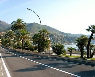
The Strade Statali, abbreviated SS, is the Italian national network of state highways. The total length for the network is about 25,000 km (16,000 mi).

<span class="mw-page-title-main">Regional road (Italy)</span> Regional road system of Italy

A strada regionale, abbreviated SR, is a type of Italian road maintained by the regions they traverse. A regional road is less important than a state highway, but more important than a provincial road.

<span class="mw-page-title-main">Provincial road (Italy)</span> Provincial road system of Italy

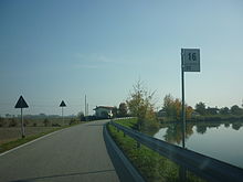
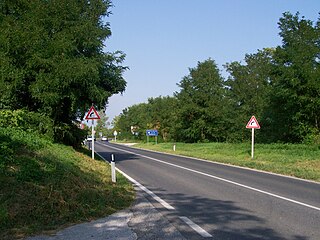
A strada provinciale, abbreviated SP, is an Italian road that is maintained by provinces or metropolitan cities. In Veneto from 2002, state highways downgraded as provincial roads are maintained by the regional company Veneto Strade. A provincial road is less important than a regional road, but more important than municipal roads. The types of provincial roads are the same ones of state highways.

<span class="mw-page-title-main">Roads in Italy</span> Overview of the various types of roads in Italy

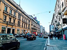
Roads in Italy are an important mode of transport in Italy. The classification of the roads of Italy is regulated by the Italian traffic code, both from a technical and administrative point of view. The street nomenclature largely reflects the administrative classification. Italy is one of the countries with the most vehicles per capita, with 690 per 1000 people in 2010.

<span class="mw-page-title-main">Trams in Lugano</span> Lugano tramway network (1896-1964)

The Lugano tramway network was part of the public transport network of Lugano, in the canton of Ticino, Switzerland, for over half a century. Opened in 1896, the network was progressively replaced by the Lugano trolleybus system by 1959, with one independent line surviving until 1964.

<span class="mw-page-title-main">Strada statale 7 Via Appia</span> Road in Italy

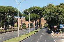
Strada statale 7 Via Appia is a motorway that follows the path of the ancient Appian Way, connecting Rome to Brindisi. In the stretch between Cisterna di Latina and Terracina, the SS 7 is called "fettuccia di Terracina" due to its straight line.

<span class="mw-page-title-main">Volt Italy</span> Political party in Italy

Volt Italia is a progressive and eurofederalist party in Italy. It is an affiliate of Volt Europa and was founded in 2018. Volt was unable to take part in the 2019 European elections, failing to obtain the required 150,000 notarised supporter signatures. Since then, the party has contested municipal and regional elections, winning a number of mandates and providing a deputy mayor since October 2021.

References

  1. "STRADE DI RILEVANTE IMPORTANZA VIABILISTICA" (in Italian). Retrieved 26 March 2024.
  2. "Via Cristoforo Colombo: no al sovrappasso di Via Pindaro" (in Italian). Retrieved 26 March 2024.
  3. 1 2 "IL PIANO REGOLATORE DELL'ILLUMINAZIONE COMUNALE" (PDF) (in Italian). Retrieved 26 March 2024.
  4. 1 2 "Definizione e classificazione delle strade" (in Italian). Retrieved 25 March 2024.
  5. Automobile Club Italia. "Codice della strada della Repubblica Italiana" [Italian Highway Code] (in Italian). Retrieved 1 February 2010.
  6. "La Provincia di Catanzaro approva il decreto di classificazione delle strade" (in Italian). Retrieved 25 March 2024.