Myaungmya District

Last updated

Myaungmya District (Burmese : မြောင်းမြခရိုင်) is a district of the Ayeyarwady Division in south western Myanmar. It consists of 5 cities. Myaungmya is the chief town of the district.

Burmese language language spoken in Myanmar

The Burmese language is the Sino-Tibetan language spoken in Myanmar where it is an official language and the language of the Bamar people, the country's principal ethnic group. Although the Constitution of Myanmar officially recognizes the English name of the language as the Myanmar language, most English speakers continue to refer to the language as Burmese, after Burma, the older name for Myanmar. In 2007, it was spoken as a first language by 33 million, primarily the Bamar (Burman) people and related ethnic groups, and as a second language by 10 million, particularly ethnic minorities in Myanmar and neighboring countries.

District Administrative division, in some countries, managed by local government

A district is a type of administrative division that, in some countries, is managed by local government. Across the world, areas known as "districts" vary greatly in size, spanning regions or counties, several municipalities, subdivisions of municipalities, school district, or political district.

Myanmar Republic in Southeast Asia

Myanmar, officially the Republic of the Union of Myanmar and also known as Burma, is a country in Southeast Asia. Myanmar is bordered by India and Bangladesh to its west, Thailand and Laos to its east and China to its north and northeast. Myanmar is the largest of the mainland Southeast Asian states.To its south, about one third of Myanmar's total perimeter of 5,876 km (3,651 mi) forms an uninterrupted coastline of 1,930 km (1,200 mi) along the Bay of Bengal and the Andaman Sea. The country's 2014 census counted the population to be 51 million people. As of 2017, the population is about 54 million. Myanmar is 676,578 square kilometres in size. Its capital city is Naypyidaw, and its largest city and former capital is Yangon (Rangoon). Myanmar has been a member of the Association of Southeast Asian Nations (ASEAN) since 1997.

Myaungmya district was formed in 1893 out of a portion of Bassein district, and reconstituted until 1903. It has an area of 2,663 square miles (6,900 km2) and a population of 280,000 and density of 104 inhabitants to the square mile. The district is a deltaic tract, bordering south on the sea and traversed by many tidal creeks. Rice cultivation and fishing occupy practically all the inhabitants of the district.

The district contains three townships: Myaungmya Township, Einme Township, and Wakema Township, ((Moulmeingyun Township)). In the Townships, there are 50 wards, 489 village groups and 2557 villages.

Myaungmya Township is a township of Myaungmya District in the Ayeyarwady Region of Myanmar. The seat lies at Myaungmya.

Einme Township Township in Ayeyarwady Region, Burma

Einme Township is a township of Myaungmya District in the Ayeyarwady Region of Myanmar. The area is believed to be where the Battle of Naungyo took place in 1539.

Wakema Township is a township of Myaungmya District in the Ayeyarwady Region of Myanmar. The township is connected to the Einme Township across the Kyungon Bridge on the Pyanmalot River.

Coordinates: 16°30′N95°00′E / 16.500°N 95.000°E / 16.500; 95.000

Geographic coordinate system Coordinate system

A geographic coordinate system is a coordinate system that enables every location on Earth to be specified by a set of numbers, letters or symbols. The coordinates are often chosen such that one of the numbers represents a vertical position and two or three of the numbers represent a horizontal position; alternatively, a geographic position may be expressed in a combined three-dimensional Cartesian vector. A common choice of coordinates is latitude, longitude and elevation. To specify a location on a plane requires a map projection.


Related Research Articles

Ayeyarwady Region Region in Lower, Myanmar

Ayeyarwady Region, is a region of Myanmar, occupying the delta region of the Ayeyarwady River. It is bordered by Bago Region to the north, Bago Region and Yangon Region to the east and the Bay of Bengal to the south and west. It is contiguous with the Rakhine State in the northwest.

Districts are the second-level administrative divisions of Myanmar. They are the sub-divisions of the States and Regions of Myanmar. According to the Myanmar Information Management Unit (MIMU), as of December 2015, there are 67 districts in Myanmar, which in turn are subdivided into townships, then towns, wards and villages.

Natogyi Township Township in Mandalay Division, Burma

NwarHtoGyi Township is a township of Myingyan District in the Mandalay Division of Burma Natogyi.

Maubin District is a district of the Ayeyarwady Division in south western Myanmar. It contains 4 cities: Maubin, Pantanaw, Nyaungdon, and Danubyu.

Pyapon District is a district of the Ayeyarwady Division in south western Myanmar. It consists 4 cities. They are Pyapon, Bogalay, Kyaiklat and Dedaye.

Manaung Township Township in Rakhine State, Burma

Manaung is a township of Kyaukpyu District in the Rakhine State of Western Myanmar. The principal town is Manaung. Manaung Township, situated on Manaung Island consists of three islands: Manaung Island, Ye Kyun Island and Taik Kyun Island. Manaung is not only a township of Kyaukpyu District but also the second biggest island of Rakhine State in Myanmar.

Ma-ubin Town in Ayeyarwady Region, Myanmar

Maubin is a town in the Ayeyarwady Division of south-west Burma. It is the seat of the Maubin Township in the Maubin District. The population as of 1993 was 42,000. The inhabitants of the town, as well as the district are mainly Bamar and Karen.

Ingapu is a town in the Ayeyarwady Division of south-west Myanmar. It is the seat of the Ingapu Township in the Hinthada District.

Taungdwingyi Township(Burmese: တောင်တွင်းကြီး မြို့နယ်) is a township of Magway District in the Magway Division of Myanmar. The principal town is Taungdwingyi. People have inhabited this area for thousands of years, and one of the earliest civilizations of Myanmar, Beikthano, the ancient Pyu city, is located near the town. The territorial area is planes, and rice, beans, grains, sugarcane, and other plants were grown there.

Sidoktaya Town in Magway Region, Myanmar

Sidoktaya, also Sitoktaya or Setoketaya is a town and seat of Sidoktaya Township in Minbu District of Magway Division, situated in middle west region of Burma. It is bordered with Salin township to the east, with Pwintbyu township to the south-east, with Ngape township to the south, with Minbya township to the west, with Kanpelek township to the north-west and with Saw township to the north. It is a hilly region of Rakhine. Mount Sun Taung, the highest mountain in Rakhine, 6,527 feet (1,989 m) high, is in Sidoktaya township.

Pakokku District is a district of the Magway Division in central Burma (Myanmar). The administrative centre is the city of Pakokku.

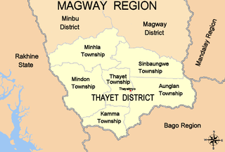
Thayet District

Thayet District is a district of the Magway Division in central Burma (Myanmar). The administrative centre is the town of Thayet.

Kale Township Township in Sagaing Region, Burma

Kale Township is a township in Kale District in the Sagaing Division of Burma (Myanmar). The principal town is Kalay.

Wuntho Township Township in Sagaing Region, Myanmar

Wuntho Township is a township in Katha District in the Sagaing Division of Burma. The principal town is Wuntho.

Kyungon, Wakema village in Ayeyarwady Region, Burma (Myanmar)

Kyungon is a village in Wakema Township, Myaungmya District, in the Ayeyarwady Region of northcentral Myanmar. Kyungon is on the left (south) bank of the Pyamalaw River across from the village of Kwinbauk.