Transport in Tanzania includes road, rail, air and maritime networks. The road network is 86,472 kilometres (53,731 mi) long, of which 12,786 kilometres (7,945 mi) is classified as trunk road and 21,105 kilometres (13,114 mi) as regional road. The rail network consists of 3,682 kilometres (2,288 mi) of track. Commuter rail service is in Dar es Salaam only. There are 28 airports, with Julius Nyerere International being the largest and the busiest. Ferries connect Mainland Tanzania with the islands of Zanzibar. Several other ferries are active on the countries' rivers and lakes.
This article is about the Transport in Zambia.

Chipata is a city and administrative centre of the Eastern Province of Zambia and Chipata District. It was declared the 5th city of the country, after Lusaka, Ndola, Kitwe and Livingstone, by President Edgar Lungu on 24 February 2017. The city has undergone rapid economic and infrastructure growth in the years, leading up to city status.

Kapiri Mposhi is a Zambian town and the seat of the Kapiri Mposhi District in Central Province. Located north of Lusaka, it stands on the Great North Road and is significant for the railway connection between the Zambia Railways line from Kitwe to Lusaka and the western terminus of the Tanzania-Zambia Railway Authority from Dar es Salaam since 1976.
Kasama is a city in the Northern Province of Zambia. It serves as the provincial capital and the headquarters of Kasama District.

The Great North Road is a major route in Zambia, running north from Lusaka through Kabwe, Kapiri Mposhi, Serenje, Mpika, Isoka and Nakonde to the border with Tanzania. The entire route is designated as the T2 road on Zambia's road network. It forms the Zambian section of the Tanzam Highway.

Mpika is a town in the Muchinga Province of Zambia, lying at the junction of the M1 Road to Kasama and Mbala and the Tanzam Highway to Dar es Salaam, Tanzania in the north-east and Lusaka in the south-west. It also has a railway station on the TAZARA Railway about 5 kilometres (3 mi) away. Mpika is situated between the Muchinga Escarpment to the east and vast miombo plains to the west. The town has an estimated population of 40,000 inhabitants (2008), while the district population is estimated at 150,000 inhabitants. Since Mpika District was the biggest district in Zambia before its division in 2017, the population density was less than 4 people per square kilometre.
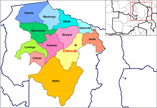
Chinsali is a town in Zambia, which is both the district headquarters of Chinsali District and provincial headquarters of Muchinga Province.
Tunduma is a city in Songwe Region, Tanzania, on the border between Tanzania and Zambia. It has border posts for both the Tanzam Highway and the TAZARA railway linking the two countries. It is located 103 km southwest of Mbeya. It is also the junction for the tarmac road which runs via Sumbawanga through the remote far western districts of Tanzania to Kasulu and Kibondo in the north-west. According to the 2022 census, it has a population of 219,309. Tunduma can be the most famous border city within SADCC countries and it is informerly known as the gateway to East Africa with the neighbour country of Zambia. Once you are in Tunduma, you can enter the town of Nakonde, in Zambia either on foot or other means of transportation.
Chilanga is a town in the Nakonde District of Muchinga Province, Zambia. It is near the border with Tanzania.

The Cairo–Cape Town Highway is Trans-African Highway 4 in the transcontinental road network being developed by the United Nations Economic Commission for Africa (UNECA), the African Development Bank (AfDB), and the African Union. The route has a length of 10,228 km (6,355 mi) and links Cairo in Egypt to Cape Town in South Africa.

Muchinga Province is one of the ten provinces of Zambia. It is located in the northeast of the country and borders with Tanzania in the north, Malawi in the east, Eastern Province in the south, Central Province in the southwest, Luapula Province in the west, and Northern Province in the northwest. The administrative center of the province is Chinsali.
The R3 highway is a primary road in Zimbabwe that runs from the capital city, Harare, to the Chirundu Border Post with Zambia. It is also known as the A1 highway. It is part of both the Beira–Lobito Highway and the Cape to Cairo Road.
Chilonga is a town in Mpika District in the Muchinga Province of Zambia.

The T2 is a trunk road in Zambia. The road runs from the Tunduma border with Tanzania via Mpika, Kabwe and Lusaka to the Chirundu border with Zimbabwe. The road is the longest route of the country, as it is approximately 1,155 kilometres (718 mi). The route from Mpika to Kafue is a toll road. The route from Tanzania to Lusaka is Zambia's Great North Road and is part of the Tanzam Highway.
Kasumbalesa is a town in Zambia that sits across the international border from the much larger town of Kasumbalesa, Democratic Republic of the Congo. It is a major crossing point for human traffic and cargo between the two countries.
The M1 road is a road in northern Zambia. It connects Mpika in Muchinga Province with Mbala in the Northern Province on the border with Tanzania and the Lake Tanganyika port of Mpulungu via Kasama. The northern section is a toll road.
Chozi is a town in the Nakonde District of Muchinga Province in Zambia.
The Iringa–Sumbawanga High Voltage Power Line, also Iringa–Mbeya–Tunduma–Sumbawanga High Voltage Power Line, is a high voltage electricity power line, under development in Tanzania. The 400 kiloVolts power line will connect the high voltage substation at Iringa, to another high voltage substation at Sumbawanga.
The M14 is a road in the Muchinga Province of Zambia that connects Nakonde with the Malawian Border at Katumbi via Chitipa, Thendere and Muyombe.
