
Gwynedd is a county in the north-west of Wales. It borders Anglesey across the Menai Strait to the north, Conwy, Denbighshire, and Powys to the east, Ceredigion over the Dyfi estuary to the south, and the Irish Sea to the west. The city of Bangor is the largest settlement, and the administrative centre is Caernarfon. The preserved county of Gwynedd, which is used for ceremonial purposes, includes the Isle of Anglesey.

Caernarfonshire, sometimes spelled Caernarvonshire or Carnarvonshire, is one of the thirteen historic counties, a vice-county and a former administrative county of Wales.
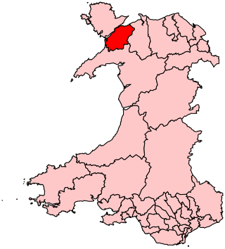
Conwy County Borough is a county borough in the north of Wales. It borders Gwynedd to the west and south and Denbighshire to the east. The largest settlement is Colwyn Bay, and Conwy is the administrative centre.

Historic Denbighshire is one of thirteen traditional counties in Wales, a vice-county and a former administrative county, which covers an area in north east Wales. It is a maritime county, bounded to the north by the Irish Sea, to the east by Flintshire, Cheshire and Shropshire, to the south by Montgomeryshire and Merionethshire, and to the west by Caernarfonshire.

Trefriw is a village and community in Conwy County Borough, Wales. It lies on the river Crafnant a few miles south of the site of the Roman fort of Canovium, sited at Caerhun. At the last three censuses, the population of the community has been recorded as 842 in 1999, 915 in 2001, and 783 in 2011.

Conwy, previously known in English as Conway, is a walled market town, community and the administrative centre of Conwy County Borough in North Wales. The walled town and castle stand on the west bank of the River Conwy, facing Deganwy on the east bank. The town formerly lay in Gwynedd and prior to that in Caernarfonshire. The community, which also includes Deganwy and Llandudno Junction, had a population of 14,753 at the 2011 census.

Colwyn was a local government district with borough status from 1974 to 1996, being one of six districts in the county of Clwyd, north-east Wales.

The Borough of Aberconwy was a local government district with borough status from 1974 to 1996, being one of five districts in the county of Gwynedd, north-west Wales.

The Borough of Arfon was local government district with borough status from 1974 to 1996, being one of five districts in the county of Gwynedd, north-west Wales.

Dwyfor was one of the five local government districts of Gwynedd, Wales from 1974 to 1996, covering the Llŷn peninsula. Its council was based in Pwllheli.

Conwy was an electoral constituency represented in the House of Commons of the Parliament of the United Kingdom. It returned one Member of Parliament (MP) by the single-member district plurality system of voting.
Arfon is a constituency in Wales represented in the House of Commons of the UK Parliament at Westminster. Although it is relatively large by geographical area, the constituency is a predominantly urban rather than rural seat, with the majority of the population living in the two towns of Bethesda and Caernarfon, as well as in the city of Bangor, on which the constituency is based. "Arfon" is a historical name for the area, meaning "facing Anglesey"; it is also the name of the former district council. This seat was created by the Welsh Boundary Commission in time for the 2010 general election; it replaced the old seat of Caernarfon. Bangor was in the old seat of Conwy. The same boundaries were used for the Arfon Welsh Assembly constituency in the 2007 Welsh Assembly election.
Llanrhos is a village in the community of Conwy, in Conwy County Borough, Wales. The village lies between the towns of Conwy and Llandudno. Llanrhos was a civil parish from 1894 until 1974. The area was formerly part of a larger parish called Eglwys Rhos or Eglwysrhos, being an old variant name for the same village. The ancient parish included Deganwy, the Craig-y-Don district of Llandudno, the Little Orme and Penrhyn Bay. The area was in the administrative county of Caernarfonshire prior to 1974.

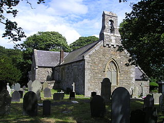
Llanrhychwyn is a hamlet in Conwy county borough, Wales. It lies in the Conwy valley, less than a mile south of Trefriw, and a mile north-west of Llanrwst. Today neighbouring Trefriw is a village with a population of around 600, but in the time of Llywelyn Fawr, and up to the early 19th century, Llanrhychwyn was larger than Trefriw, which consisted simply of "a few houses here and there". Indeed, even today both Trefriw and Llanrhychwyn lie within the parish of Llanrhychwyn. The area around Llanrhychwyn had a population of only 178 in 2011.
Geirionydd was a rural district in the administrative county of Caernarvonshire, North Wales from 1894 to 1934.
Ogwen was a rural district in the administrative county of Caernarfonshire in Wales from 1894 to 1974.
Aled was a rural district in the administrative county of Denbighshire, Wales, from 1935 to 1974.
Conwy County Borough Council is the local authority for Conwy County Borough, one of the principal areas of Wales.

Maenan is a rural settlement in Conwy, Wales, located approximately 4 miles to the north of Llanrwst and 3 miles to the south of the village of Eglwysbach. The population of the area is approximately 300 people, and more than 75% of the population are Welsh speakers. Maenan shares a community council with the nearby village of Llanddoged. The A470 trunk road passes through Maenan. The 2001 census shows that the villages of Llanddoged and Maenan had a combined population of 574.

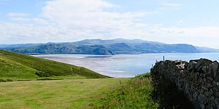
Morfa Conwy is a spit formed originally of marshy sand, north of the western end of the modern A55 entrance to Conwy in Conwy county borough, north-west Wales. A widely used corruption of the place name is Conwy Morfa, likely to have come about from the nearby Conway Marsh changing to Conway Morfa. The North Wales Coast Line railway once had a stop at 'Conway Morfa'.