National Disaster Risk Reduction and Management Council

Last updated

National Disaster Risk Reduction and Management Council
Pambansang Sanggunian para sa Pagtugon ng Sakuna
NDRRMC logo.svg
Agency overview
FormedJune 11, 1978;45 years ago (1978-06-11)
Preceding agency
  • National Disaster Coordinating Council (June 11, 1978–August 2011)
TypeStrategic Emergency Management
JurisdictionNational
Headquarters Camp Aguinaldo, EDSA cor. Boni Serrano, Quezon City, Philippines
14°36′49″N121°03′54″E / 14.61361°N 121.06500°E / 14.61361; 121.06500
Agency executive
Parent agency Department of National Defense
Website ndrrmc.gov.ph

The National Disaster Risk Reduction and Management Council (NDRRMC), formerly known as the National Disaster Coordinating Council (NDCC) until August 2011, is a working group of various government, non-government, civil sector and private sector organizations of the Government of the Republic of the Philippines established on June 11, 1978 by Presidential Decree 1566. [1] It is administered by the Office of Civil Defense (OCD) under the Department of National Defense (DND). The council is responsible for ensuring the protection and welfare of the people during disasters or emergencies. The NDRRMC plans and leads the guiding activities in the field of communication, warning signals, emergency, transportation, evacuation, rescue, engineering, health and rehabilitation, public education and auxiliary services such as fire fighting and the police in the country. The Council utilizes the UN Cluster Approach in disaster management. [2] It is the country's focal for the ASEAN Agreement on Disaster Management and Emergency Response (AADMER) and many other related international commitments.

Contents

Council membership

On May 27, 2010, during the administration of Gloria Macapagal-Arroyo, the Philippine Disaster Risk Reduction and Management Act of 2010 (RA 10121) was signed into law. The agency started to use the National Disaster Risk Reduction and Management Council (NDRRMC) name on October 2010 where it concurrently used with the National Disaster Coordinating Council (NDCC) until the NDCC name was entirely phased out on August 2011 during the administration of Arroyo's successor Benigno Aquino III. The following heads of agencies compose the NDRRMC: [3] [4]

As of June 30, 2022, these are the following members of the council:

PositionEx-officio Member
Chairperson Secretary of National Defense
Executive Director of Disaster Risk Reduction and Management Under Secretary of the National Disaster Risk Reduction and Management Council
Vice Chairperson for Disaster Preparedness Secretary of the Interior and Local Government
Vice Chairperson for Disaster Prevention and Mitigation Secretary of Science and Technology
Vice Chairperson for Disaster Response Secretary of Social Welfare and Development
Vice Chairperson for Rehabilitation and RecoveryDirector-General, National Economic and Development Authority
Members Secretary of Health
Secretary of Environment and Natural Resources
Secretary of Information and Communications Technology
Secretary of Agriculture
Secretary of Education
Secretary of Energy
Secretary of Finance
Secretary of Trade and Industry
Secretary of Transportation
Secretary of Budget and Management
Secretary of Public Works and Highways
Secretary of Foreign Affairs
Secretary of Justice
Secretary of Labor and Employment
Secretary of Tourism
Executive Secretary
Presidential Adviser on the Peace Process
Chairperson, Commission on Higher Education
Chief of Staff of the Armed Forces of the Philippines
Chief of the Philippine National Police
Commandant of the Philippine Coast Guard
Press Secretary
Secretary-General of the Philippine Red Cross
Commissioner of the National Anti-Poverty Commission - Victims of Disasters and Calamities Sector
Chairperson of the Philippine Commission on Women
Secretary of the Human Settlements and Urban Development
Executive-Director of the Climate Change Office of the Climate Change Commission
President of the Government Service Insurance System
President of the Social Security System
President of the Philippine Health Insurance Corporation
President of the Union of Local Authorities of the Philippines
President of the League of Provinces of the Philippines
President of the League of Municipalities of the Philippines
President of the League of Cities of the Philippines
President of the Liga ng Mga Barangay
Four representatives from Civil Society Organizations
One representative from the Private Sector
Administrator of the Office of Civil Defense
Chief of the Presidential Management Staff
Special Assistant to the President

Local DRRM Offices

According of Republic Act 10121, various local governments throughout the country should establish Local DRRM Offices at the regional, provincial, municipal, city and barangay levels. [5] As functional arms of the local governments, these Offices are responsible to create a Local Disaster Risk Reduction and Management Plan according to the Framework of the NDRRMC covering 4 aspects including disaster preparedness, response, prevention and mitigation, and rehabilitation and recovery. [6]

Local Offices usually have a Chief DRRM Officer supported by Administrative and Training, Research and Planning, Operations and Warning Officers. Some of these Offices have advanced to organizing their own search and rescue and emergency medical services squads and command-control-and-communications centers.

Disaster response

Typhoon Haiyan (Yolanda)

The NDRRMC was in charge of gathering and reporting data in the wake of Typhoon Haiyan. On November 15, 2014, the agency reported 5,632 deaths, 1,140 people missing and 12,166 injured. [7] The agency has reported the rose of death toll to 6,190 deaths, 1,785 missing and 28, 626 injured. They also estimated that the typhoon cost ₱36.6 billion damage to the infrastructure and agriculture of the Visayan Region. [8] As of April 17, 2015, the National Disaster Risk Reduction and Management Council confirmed total of 6,300 deaths including 5,877 of those taking place in the Eastern Visayas. [9]

Mount Pinatubo Eruption

When the population was put into a state of alert during the first phases of the Pinatubo crisis, authorities from the NDCC showed indisputable efficiency in managing the people. [10]

Precautionary Measures Before Sensing an Eruption

Prior the eruption, no precautionary measures were taken until signs of activity were observed in 1991. This could be attributed to the absence of any oral or written records of volcanic activity for the past 400 years in the surrounding areas. [11]

Precautionary Measures After Sensing an Eruption

By April 3, 1991, PHIVOLCS, after having concluded that the volcano was reawakening, decided to evacuate Aetas villages that were lying within a radius of 10 km around the summit. On May 13, 1991, a 5-level warning and evacuation system was constituted. This system included a concentric danger zone surrounding the volcano, continuously fixing four radii of evacuation from 10 to 40 kilometers between June 7 and 18, which mostly depended on the evolution of the threat. On the day of June 26, 1991, orders of evacuation were conveyed to local authorities or Coordination Councils (DCC). During those times, the entire zone located within the 10 km radius around the crater of Pinatubo has been decreed as permanent high risk sector by PHIVOLCS prohibiting all human occupation of the zone. [12]

In the time of Pinatubo’s eruptive phase in June 1991, most of the population reacted favorably to the evacuation orders due to the early preparation and coordination efforts the authorities on the field have demonstrated. However, there were still some Aetas that changed their minds and decided to return to the mountains seeking refuge in caves and spiritual comfort from their God. There were also others that refused to leave, having been convinced that the expected eruption would not be extreme enough to reach their homes, and having been scared at the thought of having to abandon their belongings and crops. By the time the second warning was given out in July 1992, the population, having been more aware of previous events, were much more prepared. Despite the PHIVOLCS frequent pleas and the population's positive response to it though, a total of 300 Aetas families still refused to evacuate.

Post-disaster Recovery

Under the DRRM Act, the National Economic and Development Authority (NEDA) is designated as the lead agency for the recovery. NEDA is mandated to coordinate the recovery support functions of national government agencies, local governments, and civil society organizations (CSOs). However, during the recovery from Typhoon Haiyan, NDRRMC was caught unprepared due to the typhoon's overwhelming impacts. It was in this context that the government, through the President's Memorandum Order 62 of December 2013, created the Office of the Presidential Assistant for Rehabilitation and Recovery (OPARR) to focus exclusively on coordinating the recovery process. OPARR aims to unify efforts of the government and other institutions involved in recovery. It has special power to mobilize the full resources of the country and to expedite the decision-making process under the direct authority of the President. OPARR was dissolved after two years.

See also

Related Research Articles

<span class="mw-page-title-main">Mayon</span> Stratovolcano in the Philippines

Mayon, also known as Mount Mayon and Mayon Volcano, is an active stratovolcano in the province of Albay in Bicol, Philippines. A popular tourist spot, it is renowned for its "perfect cone" because of its symmetric conical shape, and is regarded as sacred in Philippine mythology.

<span class="mw-page-title-main">Mount Pinatubo</span> Active stratovolcano in the Philippines

Mount Pinatubo is an active stratovolcano in the Zambales Mountains, located on the tripoint boundary of the Philippine provinces of Zambales, Tarlac and Pampanga, all in Central Luzon on the northern island of Luzon. Its eruptive history was unknown to most before the pre-eruption volcanic activity of early 1991. Pinatubo was heavily eroded and obscured from view by dense forests which supported a population of several thousand indigenous Aetas.

<span class="mw-page-title-main">Taal Volcano</span> Volcano in the Philippines

Taal Volcano is a large caldera filled by Taal Lake in the Philippines. Located in the province of Batangas about 50 kilometers (31 mi) south of Manila, the volcano is the second most active volcano in the country with 38 recorded historical eruptions, all of which were concentrated on Volcano Island, near the middle of Taal Lake. The caldera was formed by prehistoric eruptions between 140,000 and 5,380 BP.

Dr. Raymundo Santiago Punongbayan was the former director of the Philippine Institute of Volcanology and Seismology (PHIVOLCS) from 1983 to 2002. Punongbayan became popular after handling two well-known calamities, the 1990 Luzon earthquake and the 1991 Pinatubo eruption. PHIVOLCS is the government agency in charge of conducting volcanic and earthquake monitoring in order to generate data that could be used to predict volcanic eruptions and earthquake occurrences.

<span class="mw-page-title-main">Typhoon Yunya (1991)</span> Pacific typhoon in 1991

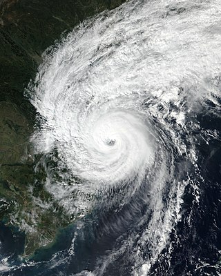
Typhoon Yunya, known in the Philippines as Typhoon Diding, was a strong tropical cyclone whose landfall in the Philippines coincided with the 1991 eruption of Mount Pinatubo. A small tropical cyclone, Yunya rapidly developed from a tropical disturbance near East Samar on June 11. By June 13 the storm had reached typhoon status as it moved west-northwest near the Philippines. Yunya attained its peak intensity the following day with estimated winds of 145 km/h (90 mph); however, strong wind shear soon impacted the typhoon and caused it to rapidly decay. The storm struck southern Luzon early on June 15 as a minimal typhoon before moving over the South China Sea later that day. After turning north and weakening to a tropical depression, the system brushed the southern tip of Taiwan on June 16 before dissipating the following day.

The Philippines is a typhoon-prone country, with approximately 20 typhoons entering its area of responsibility each year. Locally known generally as bagyo, typhoons regularly form in the Philippine Sea and less regularly, in the South China Sea, with the months of June to September being the most active, August being the month with the most activity. Each year, at least ten typhoons are expected to hit the island nation, with five expected to be destructive and powerful. In 2013, Time declared the country as the "most exposed country in the world to tropical storms".

<span class="mw-page-title-main">Mount Bulusan</span> Volcano in the Philippines

Mount Bulusan, also known as Bulusan Volcano, is a stratovolcano on the island of Luzon in the Philippines. Located in the province of Sorsogon in the Bicol Region, it is 70 kilometres (43 mi) southeast of Mayon Volcano and approximately 390 kilometres (240 mi) southeast of Manila. Bulusan is one of the active volcanoes in the Philippines.

<span class="mw-page-title-main">Typhoon Durian</span> Pacific typhoon in 2006

Typhoon Durian, known in the Philippines as Typhoon Reming, was a deadly tropical cyclone that wreaked havoc in the Philippines and later crossed the Malay Peninsula in late November 2006, causing massive loss of life when mudflows from the Mayon Volcano buried many villages.

<span class="mw-page-title-main">Philippine Institute of Volcanology and Seismology</span> Government agency in the Philippines

The Philippine Institute of Volcanology and Seismology is a Philippine national institution dedicated to provide information on the activities of volcanoes, earthquakes, and tsunamis, as well as other specialized information and services primarily for the protection of life and property and in support of economic, productivity, and sustainable development. It is one of the service agencies of the Department of Science and Technology.

<span class="mw-page-title-main">Lake Pinatubo</span> Philippines volcanic lake

Lake Pinatubo is the summit crater lake of Mount Pinatubo formed after its climactic eruption on June 15, 1991. The lake is located in Botolan, Zambales, near the boundaries of Pampanga and Tarlac provinces in the Philippines. It is about 90 km (56 mi) northwest of the capital city of Manila. While one paper by researchers from Japan suggested a depth of 600 m (2,000 ft), more detailed research suggests that 95–115 m (312–377 ft) is more accurate.

<span class="mw-page-title-main">1991 eruption of Mount Pinatubo</span> Volcanic eruption in the Philippines

The 1991 eruption of Mount Pinatubo in the Philippines' Luzon Volcanic Arc was the second-largest volcanic eruption of the 20th century, behind only the 1912 eruption of Novarupta in Alaska. Eruptive activity began on April 2 as a series of phreatic explosions from a fissure that opened on the north side of Mount Pinatubo. Seismographs were set up and began monitoring the volcano for earthquakes. In late May, the number of seismic events under the volcano fluctuated from day-to-day. Beginning June 6, a swarm of progressively shallower earthquakes accompanied by inflationary tilt on the upper east flank of the mountain, culminated in the extrusion of a small lava dome.

<span class="mw-page-title-main">Tropical Storm Nock-ten</span> Pacific severe tropical storm in 2011

Severe Tropical Storm Nock-ten, known in the Philippines as Tropical Storm Juaning, was a strong tropical storm which made a total of four landfalls in Southeast Asia, killing more than 100 people and causing damage estimated at US$126 million. It was the eighth named storm and the fourth severe tropical storm of the 2011 Pacific typhoon season.

<span class="mw-page-title-main">Typhoon Nanmadol (2011)</span> Pacific typhoon in 2011

Typhoon Nanmadol, known in the Philippines as Super Typhoon Mina, was the strongest tropical cyclone in 2011 to hit the Philippines and also the second most intense tropical cyclone worldwide in 2011, and the first of the year to directly impact Taiwan and the rest of the Republic of China (ROC). Becoming the eleventh named storm, the seventh severe tropical storm and the fourth typhoon of the 2011 Pacific typhoon season, Nanmadol made a total of three landfalls killing 26, and causing widespread damage worth US$26,464,591. The area of low pressure that was about to become Nanmadol formed on August 19. It drifted north and became a tropical depression on August 21, a tropical storm on August 23 and a typhoon on the same night. Nanmadol reached peak strength with winds of 105 knots and 140 knots threatening the Philippines with heavy rain and flash flooding.

<span class="mw-page-title-main">Tropical Storm Aere (2011)</span> Pacific tropical storm in 2011

Tropical Storm Aere, known in the Philippines as Tropical Storm Bebeng, was a mild tropical storm that affected eastern Philippines and southern Japan. It was the first named storm of the 2011 Pacific typhoon season. Aere is the Marshallese word for storm.

<span class="mw-page-title-main">Tropical Storm Bolaven (2018)</span> Pacific tropical storm in 2018

Tropical Storm Bolaven, known in the Philippines as Tropical Storm Agaton, was an early-season tropical cyclone that affected southern parts of the Philippines in January 2018. The first named storm of the 2018 Pacific typhoon season, Bolaven formed as a tropical depression near Palau on December 29, 2017. The system moved generally westwards without intensifying and made landfall over northeastern Mindanao on January 1, 2018. The depression spent the next day traversing the Philippines, making four more landfalls in the Visayas and one in Palawan. The system strengthened into a tropical storm on January 3 as it entered the South China Sea, receiving the name Bolaven. However, Bolaven weakened back to a tropical depression just a day later amid a marginal environment and dissipated on January 4 east of Vietnam.

On April 22, 2019, a 6.1 magnitude earthquake struck the island of Luzon in the Philippines, leaving at least 18 dead, three missing and injuring at least 256 others. Despite the fact that the epicenter was in Zambales, most of the damage to infrastructure occurred in the neighboring province of Pampanga, which suffered damage to 29 buildings and structures.

<span class="mw-page-title-main">2020–2022 Taal Volcano eruptions</span> Volcanic eruption in the Philippines

Taal Volcano in Batangas, Philippines began to erupt on January 12, 2020, when a phreatomagmatic eruption from its main crater spewed ashes over Calabarzon, Metro Manila, and some parts of Central Luzon and Ilocos Region, resulting in the suspension of school classes, work schedules, and flights in the area. The Philippine Institute of Volcanology and Seismology (PHIVOLCS) subsequently issued an Alert Level 4, indicating "that a hazardous explosive eruption is possible within hours to days." Volcanic activity continued into 2021, when smaller eruptions occurred in July 2021. On 26 March 2022, a short-lived phreatomagmatic eruption was recorded by PHIVOLCS raising the status from Alert level 2 to Alert level 3 as well as surrounding towns.

<span class="mw-page-title-main">Typhoon Goni</span> Pacific typhoon in 2020

Typhoon Goni, known in the Philippines as Super Typhoon Rolly, was an extremely powerful tropical cyclone that made landfall as a Category 5 equivalent super typhoon on Catanduanes in the Philippines, and in Vietnam as a tropical storm. It was the strongest landfalling tropical cyclone on record by 1-minute maximum sustained winds. The name "Goni" which means swan in Korean. The nineteenth named storm, ninth typhoon, and second super typhoon of the 2020 Pacific typhoon season, Goni originated as a tropical depression south portion of Guam on October 26. It was then named as Tropical Storm Goni on October 27. On the next day, Goni explosively intensified over the Philippine Sea, becoming a Category 5–equivalent super typhoon on October 30. Goni maintained Category 5 strength for over a day, before making landfall on Catanduanes at peak intensity, with 10-minute sustained winds of 220 km/h (135 mph), and 1-minute sustained winds of 315 km/h (195 mph), with a minimum central pressure of 905 hPa. It was the most intense tropical cyclone observed worldwide in 2020.

<span class="mw-page-title-main">Typhoon Vamco</span> Pacific typhoon in 2020

Typhoon Vamco, known in the Philippines as Typhoon Ulysses, was a powerful and very destructive Category 4-equivalent typhoon that struck the Philippines and Vietnam. It also caused the worst flooding in Metro Manila since Typhoon Ketsana in 2009. The twenty-second named storm and tenth typhoon of the 2020 Pacific typhoon season, Vamco originated as a tropical depression northwest of Palau, where it slowly continued its northwest track until it made landfall in Quezon. After entering the South China Sea, Vamco further intensified in the South China Sea until it made its last landfall in Vietnam.

References

  1. "Presidential Decree No. 1566, s. 1978". Official Gazette of the Republic of the Philippines. June 11, 1978. Retrieved January 20, 2023.
  2. Shaw, Rajib (March 6, 2012). Community-Based Disaster Risk Reduction. Emerald Group Publishing. p. 212. ISBN   9780857248671.
  3. "FAST FACTS: The NDRRMC". Rappler. July 11, 2014 [November 16, 2013]. Retrieved August 22, 2014.
  4. "Republic Act No. 10121". Official Gazette . Presidential Communications Development and Strategic Planning Office. PREGINET. 2010. Retrieved January 2, 2019.
  5. "The role of LGUs, local councils during disasters". Rappler. July 11, 2014 [November 21, 2013]. Retrieved August 22, 2014.
  6. NDRRMC Framework
  7. "US sends 1000 more troops as Philippines typhoon aid faces challenges". Fox News. Retrieved November 15, 2013.
  8. "NDRRMC : Yolanda death toll rises to 6,190". Philippine Star. January 9, 2014. Retrieved August 22, 2014.
  9. "US sends 1000 more troops as Philippines typhoon aid faces challenges" (PDF). National Disaster Risk Reduction and Management Council. April 17, 2014. Archived from the original (PDF) on October 6, 2014. Retrieved August 22, 2014.
  10. Frédéric, Leone, and Jean-Christophe Gaillard. "Analysis of the institutional and social responses to the eruption and the lahars of Mount Pinatubo volcano from 1991 to 1998 (Central Luzon, Philippines)." GeoJournal no. 2 (1999): 223. JSTOR Journals, EBSCOhost.
  11. Newhall, Christopher G., James W. Hendley, and Peter H. Stauffer. The cataclysmic 1991 eruption of Mount Pinatubo, Philippines. Vancouver, WA?: U.S. Geological Survey, 1997.
  12. Frédéric, Leone, and Jean-Christophe Gaillard. "Analysis of the institutional and social responses to the eruption and the lahars of Mount Pinatubo volcano from 1991 to 1998 (Central Luzon, Philippines)." GeoJournal no. 2 (1999): 223. JSTOR Journals, EBSCOhost.