
A geographic information system (GIS) consists of integrated computer hardware and software that store, manage, analyze, edit, output, and visualize geographic data. Much of this often happens within a spatial database, however, this is not essential to meet the definition of a GIS. In a broader sense, one may consider such a system also to include human users and support staff, procedures and workflows, the body of knowledge of relevant concepts and methods, and institutional organizations.

Topologically Integrated Geographic Encoding and Referencing, or TIGER, or TIGER/Line is a format used by the United States Census Bureau to describe land attributes such as roads, buildings, rivers, and lakes, as well as areas such as census tracts. TIGER was developed to support and improve the Bureau's process of taking the Decennial Census.
IPUMS, which originally stood for Integrated Public Use Microdata Series but no longer abbreviates anything, is the world's largest individual-level population database. IPUMS consists of microdata samples from United States (IPUMS-USA) and international (IPUMS-International) census records, as well as data from U.S. and international surveys. The records are converted into a consistent format and made available to researchers through a web-based data dissemination and analysis system.
A GIS software program is a computer program to support the use of a geographic information system, providing the ability to create, store, manage, query, analyze, and visualize geographic data, that is, data representing phenomena for which location is important. The GIS software industry encompasses a broad range of commercial and open-source products that provide some or all of these capabilities within various information technology architectures.

The 1840 United States census was the sixth census of the United States. Conducted by U.S. marshals on June 1, 1840, it determined the resident population of the United States to be 17,069,453 – an increase of 32.7 percent over the 12,866,020 persons enumerated during the 1830 census. The total population included 2,487,355 slaves. In 1840, the center of population was about 260 miles (418 km) west of Washington, near Weston, Virginia.

The Vector Map (VMAP), also called Vector Smart Map, is a vector-based collection of geographic information system (GIS) data about Earth at various levels of detail. Level 0 (low resolution) coverage is global and entirely in the public domain. Level 1 (global coverage at medium resolution) is only partly in the public domain.
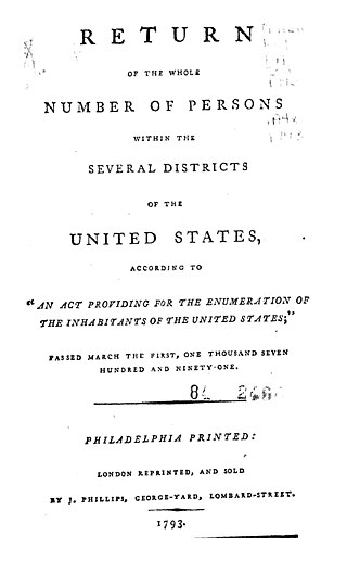
The 1790 United States census was the first United States census. It recorded the population of the whole United States as of Census Day, August 2, 1790, as mandated by Article 1, Section 2, of the Constitution and applicable laws. In the first census, the population of the United States was enumerated to be 3,929,214 inhabitants.
The 1830 United States census, the fifth census undertaken in the United States, was conducted on June 1, 1830. The only loss of census records for 1830 involved some countywide losses in Massachusetts, Maryland, and Mississippi.

The 1880 United States census, conducted by the Census Office during June 1880, was the tenth United States census. It was the first time that women were permitted to be enumerators. The Superintendent of the Census was Francis Amasa Walker. This was the first census in which a city—New York City—recorded a population of over one million, and the first census in which the 20 most populated cities all recorded over 100,000 residents.
Geospatial metadata is a type of metadata applicable to geographic data and information. Such objects may be stored in a geographic information system (GIS) or may simply be documents, data-sets, images or other objects, services, or related items that exist in some other native environment but whose features may be appropriate to describe in a (geographic) metadata catalog.

Web mapping or an online mapping is the process of using, creating, and distributing maps on the World Wide Web, usually through the use of Web geographic information systems. A web map or an online map is both served and consumed, thus, web mapping is more than just web cartography, it is a service where consumers may choose what the map will show.
A historical geographic information system is a geographic information system that may display, store and analyze data of past geographies and track changes in time. It can be regarded as a tool for historical geography.
The Great Britain Historical GIS is a spatially enabled database that documents and visualises the changing human geography of the British Isles, although is primarily focussed on the subdivisions of the United Kingdom mainly over the 200 years since the first census in 1801. The project is currently based at the University of Portsmouth, and is the provider of the website A Vision of Britain through Time.
A Spatial Data Infrastructure (SDI), also called geospatial data infrastructure, is a data infrastructure implementing a framework of geographic data, metadata, users and tools that are interactively connected in order to use spatial data in an efficient and flexible way. Another definition is "the technology, policies, standards, human resources, and related activities necessary to acquire, process, distribute, use, maintain, and preserve spatial data".
A geographic data model, geospatial data model, or simply data model in the context of geographic information systems, is a mathematical and digital structure for representing phenomena over the Earth. Generally, such data models represent various aspects of these phenomena by means of geographic data, including spatial locations, attributes, change over time, and identity. For example, the vector data model represents geography as collections of points, lines, and polygons, and the raster data model represent geography as cell matrices that store numeric values. Data models are implemented throughout the GIS ecosystem, including the software tools for data management and spatial analysis, data stored in a variety of GIS file formats, specifications and standards, and specific designs for GIS installations.

Metadata is "data that provides information about other data", but not the content of the data itself, such as the text of a message or the image itself. There are many distinct types of metadata, including:
Geographic Information Systems (GIS) are an increasingly important component of business, healthcare, security, government, trade, media, transportation and tourism industries and operations in China. GIS software is playing an increasing role in the way Chinese companies analyze and manage business operations.
Geographic information systems (GIS) play a constantly evolving role in geospatial intelligence (GEOINT) and United States national security. These technologies allow a user to efficiently manage, analyze, and produce geospatial data, to combine GEOINT with other forms of intelligence collection, and to perform highly developed analysis and visual production of geospatial data. Therefore, GIS produces up-to-date and more reliable GEOINT to reduce uncertainty for a decisionmaker. Since GIS programs are Web-enabled, a user can constantly work with a decision maker to solve their GEOINT and national security related problems from anywhere in the world. There are many types of GIS software used in GEOINT and national security, such as Google Earth, ERDAS IMAGINE, GeoNetwork opensource, and Esri ArcGIS.

Internet GIS, or Internet geographic information system (GIS), is a term that refers to a broad set of technologies and applications that employ the Internet to access, analyze, visualize, and distribute spatial data. Internet GIS is an outgrowth of traditional GIS, and represents a shift from conducting GIS on an individual computer to working with remotely distributed data and functions. Two major issues in GIS are accessing and distributing spatial data and GIS outputs. Internet GIS helps to solve that problem by allowing users to access vast databases impossible to store on a single desktop computer, and by allowing rapid dissemination of both maps and raw data to others. These methods include both file sharing and email. This has enabled the general public to participate in map creation and make use of GIS technology.

Web GIS, or Web Geographic Information Systems, are GIS that employ the World Wide Web to facilitate the storage, visualization, analysis, and distribution of spatial information over the Internet. The World Wide Web, or the Web, is an information system that uses the internet to host, share, and distribute documents, images, and other data. Web GIS involves using the World Wide Web to facilitate GIS tasks traditionally done on a desktop computer, as well as enabling the sharing of maps and spatial data. While Web GIS and Internet GIS are sometimes used interchangeably, they are different concepts. Web GIS is a subset of Internet GIS, which is itself a subset of distributed GIS, which itself is a subset of broader Geographic information system. The most common application of Web GIS is Web mapping, so much so that the two terms are often used interchangeably in much the same way as Digital mapping and GIS. However, Web GIS and web mapping are distinct concepts, with web mapping not necessarily requiring a Web GIS.