National Register of Historic Places listings in Dillingham Census Area, Alaska

Last updated
Location of the Dillingham Census Area in Alaska Map of Alaska highlighting Dillingham Census Area.svg
Location of the Dillingham Census Area in Alaska

This is a list of the National Register of Historic Places listings in Dillingham Census Area, Alaska.

Contents

This is intended to be a complete list of the properties and districts on the National Register of Historic Places in Dillingham Census Area, Alaska, United States. The locations of National Register properties and districts for which the latitude and longitude coordinates are included below, may be seen in a Google map. [1]

National Register of Historic Places federal list of historic sites in the United States

The National Register of Historic Places (NRHP) is the United States federal government's official list of districts, sites, buildings, structures, and objects deemed worthy of preservation for their historical significance. A property listed in the National Register, or located within a National Register Historic District, may qualify for tax incentives derived from the total value of expenses incurred preserving the property.

Dillingham Census Area, Alaska Census area in the United States

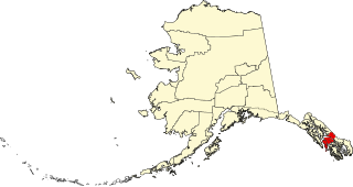
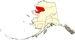
Dillingham Census Area is a census area located in the state of Alaska, United States. At the 2010 census, the population was 4,847. It is part of the unorganized borough and therefore has no borough seat. Its largest community by far is the city of Dillingham, on a small arm of Bristol Bay on the Bering Sea.

Alaska State of the United States of America

Alaska is a U.S. state in the northwest extremity of North America, just across the Bering Strait from Asia. The Canadian province of British Columbia and territory of Yukon border the state to the east and southeast. Its most extreme western part is Attu Island, and it has a maritime border with Russia to the west across the Bering Strait. To the north are the Chukchi and Beaufort seas—southern parts of the Arctic Ocean. The Pacific Ocean lies to the south and southwest. It is the largest U.S. state by area and the seventh largest subnational division in the world. In addition, it is the 3rd least populous and the most sparsely populated of the 50 United States; nevertheless, it is by far the most populous territory located mostly north of the 60th parallel in North America: its population—estimated at 738,432 by the United States Census Bureau in 2015— is more than quadruple the combined populations of Northern Canada and Greenland. Approximately half of Alaska's residents live within the Anchorage metropolitan area. Alaska's economy is dominated by the fishing, natural gas, and oil industries, resources which it has in abundance. Military bases and tourism are also a significant part of the economy.

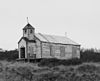
There are 3 properties and districts listed on the National Register in the census area, including one National Historic Landmark District. Another property was once listed but has been delisted.

This National Park Service list is complete through NPS recent listings posted May 18, 2018. [2]
Map all coordinates using: OpenStreetMap  ·  Google Maps
Download coordinates as: KML  ·  GPX

Current listings

[3] Name on the Register [4] Image Date listed [5] Location City or town Description
1 St. Nicholas Chapel
St. Nicholas Chapel St. Nicholas Church, Ekuk, Alaska.jpg
St. Nicholas Chapel
June 6, 1980
(#80000749)
On a bluff about 1 mile (1.6 km) south of Ekuk
58°47′53″N158°33′04″W / 58.79815°N 158.55108°W / 58.79815; -158.55108 (St. Nicholas Chapel)
Ekuk
2 Transfiguration of Our Lord Chapel
Transfiguration of Our Lord Chapel Russian Church, Nushagak, Alaska.png
Transfiguration of Our Lord Chapel
June 6, 1980
(#80000752)
In Nushagak
58°56′47″N158°29′27″W / 58.94644°N 158.49074°W / 58.94644; -158.49074 (Transfiguration of Our Lord Chapel)
Nushagak
3 Walrus Islands Archeological District
Walrus Islands Archeological District Round Island-2.jpg
Walrus Islands Archeological District
December 23, 2016
(#100000875)
Bristol Bay
58°41′16″N160°08′20″W / 58.68764°N 160.13878°W / 58.68764; -160.13878 (Walrus Islands Archeological District)
Togiak

Former listings

[3] Name on the RegisterImageDate listedDate removedLocationCity or townSummary
1 Fishermen's Co-op Upload image April 13, 1995
(#95000400)
August 11, 1999247 Main Street
Dillingham

See also

This is a list of properties and districts listed on the National Register of Historic Places in Alaska. There are approximately 400 listed sites in Alaska. Each of the state's 28 boroughs and census areas has at least two listings on the National Register, except for the Kusilvak Census Area, which has none.

Related Research Articles

National Register of Historic Places listings in Aleutians West Census Area, Alaska Wikimedia list article

This is a list of the National Register of Historic Places listings in Aleutians West Census Area, Alaska.

National Register of Historic Places listings in Bethel Census Area, Alaska Wikimedia list article

This is a list of the National Register of Historic Places listings in Bethel Census Area, Alaska.

National Register of Historic Places listings in Hoonah–Angoon Census Area, Alaska Wikimedia list article

This is a list of the National Register of Historic Places listings in Hoonah–Angoon Census Area, Alaska.

National Register of Historic Places listings in Petersburg Borough, Alaska Wikimedia list article

This is a list of the National Register of Historic Places listings in Petersburg, Alaska.

National Register of Historic Places listings in Nome Census Area, Alaska Wikimedia list article

This is a list of the National Register of Historic Places listings in Nome Census Area, Alaska.

National Register of Historic Places listings in Prince of Wales–Hyder Census Area, Alaska Wikimedia list article

This is a list of the National Register of Historic Places listings in Prince of Wales–Hyder Census Area, Alaska.

National Register of Historic Places listings in Southeast Fairbanks Census Area, Alaska Wikimedia list article

This is a list of the National Register of Historic Places listings in Southeast Fairbanks Census Area, Alaska.

National Register of Historic Places listings in Valdez–Cordova Census Area, Alaska Wikimedia list article

This is a list of the National Register of Historic Places listings in Valdez–Cordova Census Area, Alaska.

National Register of Historic Places listings in Yukon–Koyukuk Census Area, Alaska Wikimedia list article

This is a list of the National Register of Historic Places listings in Yukon–Koyukuk Census Area, Alaska.

National Register of Historic Places listings in Yakutat, Alaska Wikimedia list article

This is a list of the National Register of Historic Places listings in Yakutat, Alaska.

National Register of Historic Places listings in Wrangell, Alaska Wikimedia list article

This is a list of the National Register of Historic Places listings in Wrangell, Alaska.

National Register of Historic Places listings in Sitka, Alaska Wikimedia list article

This is a list of the National Register of Historic Places listings in Sitka, Alaska.

National Register of Historic Places listings in Aleutians East Borough, Alaska Wikimedia list article

This is a list of the National Register of Historic Places listings in Aleutians East Borough, Alaska.

National Register of Historic Places listings in Bristol Bay Borough, Alaska Wikimedia list article

This is a list of the National Register of Historic Places listings in Bristol Bay Borough, Alaska.

National Register of Historic Places listings in Haines Borough, Alaska Wikimedia list article

This is a list of the National Register of Historic Places listings in Haines Borough, Alaska.

National Register of Historic Places listings in Kenai Peninsula Borough, Alaska Wikimedia list article

This is a list of the National Register of Historic Places listings in Kenai Peninsula Borough, Alaska.

National Register of Historic Places listings in Ketchikan Gateway Borough, Alaska Wikimedia list article

This is a list of the National Register of Historic Places listings in Ketchikan Gateway Borough, Alaska.

National Register of Historic Places listings in Northwest Arctic Borough, Alaska Wikimedia list article

This is a list of the National Register of Historic Places listings in Northwest Arctic Borough, Alaska.

This is a list of the National Register of Historic Places listings in Wrangell–St. Elias National Park and Preserve.

This is a list of the National Register of Historic Places listings in Katmai National Park and Preserve.

References

  1. The latitude and longitude information provided in this table was derived originally from the National Register Information System, which has been found to be fairly accurate for about 99% of listings. For about 1% of NRIS original coordinates, experience has shown that one or both coordinates are typos or otherwise extremely far off; some corrections may have been made. A more subtle problem causes many locations to be off by up to 150 yards, depending on location in the country: most NRIS coordinates were derived from tracing out latitude and longitudes off of USGS topographical quadrant maps created under the North American Datum of 1927 , which differs from the current, highly accurate WGS84 GPS system used by most on-line maps. Chicago is about right, but NRIS longitudes in Washington are higher by about 4.5 seconds, and are lower by about 2.0 seconds in Maine. Latitudes differ by about 1.0 second in Florida. Some locations in this table may have been corrected to current GPS standards.
  2. "National Register of Historic Places: Weekly List Actions". National Park Service, United States Department of the Interior. Retrieved on May 18, 2018.
  3. 1 2 Numbers represent an ordering by significant words. Various colorings, defined here, differentiate National Historic Landmarks and historic districts from other NRHP buildings, structures, sites or objects.
  4. National Park Service (2008-04-24). "National Register Information System". National Register of Historic Places . National Park Service.
  5. The eight-digit number below each date is the number assigned to each location in the National Register Information System database, which can be viewed by clicking the number.