National Tsunami Warning Center

Last updated
Tsunami evacuation routes are found in some regions prone to tsunamis Tsunami Evacuation Route Sign Southern California 8176008396 o.jpg
Tsunami evacuation routes are found in some regions prone to tsunamis

The National Tsunami Warning Center (NTWC) is one of two tsunami warning centers in the United States, covering all coastal regions of the United States and Canada, except Hawaii, Guam, the Northern Mariana Islands, Puerto Rico and the U.S. Virgin Islands. Until 2013, it was known as the West Coast and Alaska Tsunami Warning Center.

Contents

The NTWC, operated by the National Oceanic and Atmospheric Administration (NOAA), detects and analyzes earthquakes worldwide, issuing warnings to local officials in the hazard zones about the advisability of evacuating low-lying coastal areas and moving ships to deep water.

The Pacific Tsunami Warning Center has the responsibility for areas of the U.S. which are not covered by NTWC.

History

Following the March 27, 1964 Alaska earthquake and tsunami, the NTWC (formerly known as The Palmer Observatory) was established in 1967 in Palmer, Alaska, under the auspices of the United States Coast and Geodetic Survey. This earthquake alerted State and Federal officials that a facility was necessary to provide timely and effective tsunami warnings and earthquake information to the coastal areas of Alaska. Congress provided funds in 1965 to construct two new observatories and establish a tsunami warning system in Alaska. The first observatory constructed was at the U.S. Naval Station on Adak Island in the Andreanof Islands in the Central Aleutians. The City of Palmer, in the Matanuska Valley 42 miles northeast of Anchorage, was selected as the site for the primary observatory due to its proximity to bedrock for instrumentation and to communications facilities. Construction of the observatory installations, the task of engineering and assembling the data systems, and the hookup of the extensive telecommunications and data telemetry network was completed in the summer of 1967. With the dedication of the Palmer Observatory on September 2, 1967, the Alaska Regional Tsunami Warning System (ARTWS) became operational.

Originally, the tsunami warning responsibility for Alaska was shared by the three observatories located at Palmer, Adak and Sitka. Sitka, a seismological observatory since 1904, and Fairbanks were the only two seismic stations operating in Alaska in 1964. The responsibilities of Adak and Sitka were limited to issuing a tsunami warning for events occurring within 300 miles of their location. In later years, the responsibility to provide tsunami warning services for Alaska was transferred from the Adak and Sitka observatories to the Palmer Observatory. Sitka and Adak Observatories were eventually closed in the early 1990s, although the seismic instrumentation is still maintained.

In 1973, the Palmer Observatory was transferred to the National Weather Service's Alaska Region and changed its name to Alaska Tsunami Warning Center (ATWC). In 1982, its area of responsibility (AOR) was enlarged to include the issuing of tsunami warnings to California, Oregon, Washington, and British Columbia for potential tsunamigenic earthquakes occurring in their coastal areas. In 1996, the responsibility was again expanded to include all Pacific-wide tsunamigenic sources that could affect the California, Oregon, Washington, British Columbia and Alaska coasts, and the name was changed to the West Coast/Alaska Tsunami Warning Center (WC/ATWC) to reflect those new responsibilities.

In 2003, a new Tsunami Warning Center building was constructed in the yard of the original building. This new facility was the first LEED certified building in the state of Alaska, and within the U.S. Department of Commerce. LEED (Leadership in Energy and Environmental Design) certification is granted by the U.S. Green Building Council, and awards environmentally sensitive construction practices. This new facility provides upgraded power and communications capability, as well as office space for the expanded staff, assuring that the center will continue to provide quality products to the public well into the future.

Following the devastating Indian Ocean tsunami in late 2004, the WC/ATWC expanded its scope to the U.S. Atlantic coast, and the Atlantic coast of Canada. On 1 October 2013, the name was changed to the National Tsunami Warning Center (NTWC) to reflect this expanded geographical zone of responsibility.

Coverage area

NTWC is the tsunami warning authority for the following regions:

CountryAreas
United States Alaska, Washington, Oregon, California, Connecticut, Delaware, Florida, Georgia, Maine, Maryland, Massachusetts, New Hampshire, New Jersey, New York, North Carolina, Rhode Island, South Carolina, Virginia, Alabama, Louisiana, Mississippi, Texas
Canada British Columbia, Nova Scotia, New Brunswick, Prince Edward Island, Newfoundland and Labrador, Quebec [1]

Other parts of the United States are covered by the Pacific Tsunami Warning Center.

Overview of operations

To accomplish its mission of providing accurate and timely tsunami bulletins to its area-of-responsibility (AOR) – which includes Canadian coastal regions, Puerto Rico and the Virgin Islands, and the ocean coasts of all U.S. States except Hawaii – the NTWC detects, locates, sizes, and analyzes earthquakes worldwide. Earthquakes that activate the Center's alarm system initiate an earthquake and tsunami investigation which includes the following four basic steps: automatic locating and sizing the earthquake; earthquake analysis and review; sea level data analysis to verify the existence of a tsunami and to calibrate models; and disseminating information to the appropriate emergency management officials.

Tsunami bulletins are issued to state/province departments of emergency services; federal disaster preparedness agencies; National Weather Service offices; Canada's Atlantic Storm Prediction Center; Federal Aviation Administration offices; the U.S. Coast Guard; military bases; local emergency managers; United States Geological Survey offices; and many other recipients located in the U.S. and Canada. Earthquakes large enough to be felt near the coast, but below the tsunami warning/watch/advisory threshold size, prompt informational statements to the same recipients as warnings to help prevent needless evacuations.

In addition to its basic functions, the Center conducts a community preparedness program intended to increase public awareness of the tsunami hazard and improve tsunami planning at the community level. The Center also actively pursues developmental projects which enhance tsunami warning operations.

The Center operates 24 hours every day with two watchstanders on duty. Center personnel are notified of activity by an alarm system which is activated by several methods:

Alert levels

NTWC Tsunami Messages [2]
Alert LevelPotential HazardPublic Action

WarningDangerous coastal flooding and powerful currentsMove to high ground or inland
AdvisoryStrong currents and waves dangerous to those in or very near waterStay out of water, away from beaches and waterways
WatchNot yet knownStay tuned for more information, be prepared to act
InformationNo threat or very distant event for which hazard has not yet been determinedNo action needed at this time

Deep-ocean tsunami detection

A diagram of the DART II system DART II System Diagram.jpg
A diagram of the DART II system

In 1995, NOAA began developing the Deep-ocean Assessment and Reporting of Tsunamis (DART) system. By 2001, an array of six stations had been deployed in the Pacific Ocean. [3]

Beginning in 2005, as a result of the tsunami caused by the 2004 Indian Ocean earthquake, plans were announced to add 32 more DART buoys to be operational by mid-2007. [4]

These stations give detailed information about tsunamis while they are still far off shore. Each station consists of a sea-bed bottom pressure recorder (at a depth of 1000–6000 m) which detects the passage of a tsunami and transmits the data to a surface buoy via acoustic modem. The surface buoy then radios the information to the NTWC via the GOES satellite system. The bottom pressure recorder lasts for two years while the surface buoy is replaced every year. The system has considerably improved the forecasting and warning of tsunamis in the Pacific Ocean.

See also

Related Research Articles

<span class="mw-page-title-main">Tsunami</span> Series of water waves caused by the displacement of a large volume of a body of water

A tsunami is a series of waves in a water body caused by the displacement of a large volume of water, generally in an ocean or a large lake. Earthquakes, volcanic eruptions and other underwater explosions above or below water all have the potential to generate a tsunami. Unlike normal ocean waves, which are generated by wind, or tides, which are in turn generated by the gravitational pull of the Moon and the Sun, a tsunami is generated by the displacement of water from a large event.

<span class="mw-page-title-main">Tsunami warning system</span> System used to detect and warn the public about impending tsunamis

A tsunami warning system (TWS) is used to detect tsunamis in advance and issue the warnings to prevent loss of life and damage to property. It is made up of two equally important components: a network of sensors to detect tsunamis and a communications infrastructure to issue timely alarms to permit evacuation of the coastal areas. There are two distinct types of tsunami warning systems: international and regional. When operating, seismic alerts are used to instigate the watches and warnings; then, data from observed sea level height are used to verify the existence of a tsunami. Other systems have been proposed to augment the warning procedures; for example, it has been suggested that the duration and frequency content of t-wave energy is indicative of an earthquake's tsunami potential.

<span class="mw-page-title-main">Pacific Tsunami Warning Center</span> One of two tsunami warning centers that are operated by NOAA, located on Ford Island, Hawaii

The Pacific Tsunami Warning Center (PTWC) is one of two tsunami warning centers in the United States, covering Hawaii, Guam, American Samoa and the Northern Mariana Islands in the Pacific, as well as Puerto Rico, the U.S. Virgin Islands and the British Virgin Islands in the Caribbean Sea. Other parts of the United States are covered by the National Tsunami Warning Center.

<span class="mw-page-title-main">1946 Aleutian Islands earthquake</span> Earthquake near the Aleutian Islands, Alaska

The 1946 Aleutian Islands earthquake occurred near the Aleutian Islands, Alaska on April 1, 1946. The shock measured 8.6, Mt 9.3 or 7.4. It had a maximum Mercalli intensity of VI (Strong). It resulted in 165–173 casualties and over US $26 million in damage. The seafloor along the fault was elevated, triggering a Pacific-wide tsunami with multiple destructive waves at heights ranging from 45–138 ft (14–42 m). The tsunami obliterated the Scotch Cap Lighthouse on Unimak Island, Alaska among others, and killed all five lighthouse keepers. Despite the destruction to the Aleutian Island Unimak, the tsunami had almost an imperceptible effect on the Alaskan mainland.

<span class="mw-page-title-main">Deep-ocean Assessment and Reporting of Tsunamis</span> Component of an enhanced tsunami warning system

Deep-ocean Assessment and Reporting of Tsunamis (DART) is a component of an enhanced tsunami warning system.

The Indian Ocean Tsunami Warning System was set up to provide warning to inhabitants of nations bordering the Indian Ocean of approaching tsunamis. The tsunami warning system has been in use since the mid-2000s.

<span class="mw-page-title-main">Aleutian Trench</span> An oceanic trench along the southern coastline of Alaska and the Aleutian islands

The Aleutian Trench is an oceanic trench along a convergent plate boundary which runs along the southern coastline of Alaska and the Aleutian islands. The trench extends for 3,400 kilometres (2,100 mi) from a triple junction in the west with the Ulakhan Fault and the northern end of the Kuril–Kamchatka Trench, to a junction with the northern end of the Queen Charlotte Fault system in the east. It is classified as a "marginal trench" in the east as it runs along the margin of the continent. The subduction along the trench gives rise to the Aleutian Arc, a volcanic island arc, where it runs through the open sea west of the Alaska Peninsula. As a convergent plate boundary, the trench forms part of the boundary between two tectonic plates. Here, the Pacific Plate is being subducted under the North American Plate at a dip angle of nearly 45°. The rate of closure is 7.5 centimetres (3 in) per year.

The 1957 Andreanof Islands earthquake occurred at 04:22 local time on March 9 with a moment magnitude estimated between 8.6 and 9.1 and a maximum Modified Mercalli intensity of VIII (Severe). It occurred south of the Andreanof Islands group, which is part of the Aleutian Islands arc. The event occurred along the Aleutian Trench, the convergent plate boundary that separates the Pacific Plate and the North American plates near Alaska. A basin-wide tsunami followed, with effects felt in Alaska and Hawaii, and strong waves recorded across the Pacific rim. Total losses were around $5 million.

<span class="mw-page-title-main">National Data Buoy Center</span>

The National Data Buoy Center (NDBC) is a part of the National Oceanic and Atmospheric Administration's (NOAA) National Weather Service (NWS). NDBC designs, develops, operates, and maintains a network of data collecting buoys and coastal stations. The NDBC is located in southern Mississippi as a tenant at the John C. Stennis Space Center, a National Aeronautics and Space Administration (NASA) facility.

<span class="mw-page-title-main">Central Weather Administration</span> Meteorological service of the Republic of China (Taiwan)

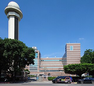
The Central Weather Administration is the government meteorological research and forecasting institution of the Republic of China (Taiwan). In addition to meteorology, the Central Weather Administration also makes astronomical observations, reports on sea conditions, and conducts research into seismology and provides earthquake reports. The Central Weather Administration is headquartered in Taipei City and is administered under the Ministry of Transportation and Communications.

<span class="mw-page-title-main">2006 Pangandaran earthquake and tsunami</span> Destructive tsunami earthquake south of Java Island

An earthquake occurred on July 17, 2006 at 15:19:27 local time along a subduction zone off the coast of west and central Java, a large and densely populated island in the Indonesian archipelago. The shock had a moment magnitude of 7.7 and a maximum perceived intensity of IV (Light) in Jakarta, the capital and largest city of Indonesia. There were no direct effects of the earthquake's shaking due to its low intensity, and the large loss of life from the event was due to the resulting tsunami, which inundated a 300 km (190 mi) portion of the Java coast that had been unaffected by the earlier 2004 Indian Ocean earthquake and tsunami that was off the coast of Sumatra. The July 2006 earthquake was also centered in the Indian Ocean, 180 kilometers (110 mi) from the coast of Java, and had a duration of more than three minutes.

<span class="mw-page-title-main">September 2007 Sumatra earthquakes</span> Earthquakes affecting Indonesia

The September 2007 Sumatra earthquakes were a series of megathrust earthquakes that struck the Sunda Trench off the coast of Sumatra, Indonesia, with three of magnitude 7 or greater. A series of tsunami bulletins was issued for the area. The most powerful of the series had a magnitude of 8.5, which makes it in the top 20 of the largest earthquakes ever recorded on a seismograph.

<span class="mw-page-title-main">Teletsunami</span> Massive tsunamis that strike a thousand kilometers or more from their source

A teletsunami is a tsunami that originates from a distant source, defined as more than 1,000 km (620 mi) away or three hours' travel from the area of interest, sometimes travelling across an ocean. All teletsunamis have been generated by major earthquakes such as the 1755 Lisbon earthquake, 1960 Valdivia earthquake, 1964 Alaska earthquake, 2004 Indian Ocean earthquake, and 2021 South Sandwich Islands earthquakes.

<span class="mw-page-title-main">2010 Chile earthquake</span> Magnitude 8.8 earthquake in Chile on 27 February 2010

The 2010 Chile earthquake and tsunami occurred off the coast of central Chile on Saturday, 27 February at 03:34 local time, having a magnitude of 8.8 on the moment magnitude scale, with intense shaking lasting for about three minutes. It was felt strongly in six Chilean regions that together make up about 80 percent of the country's population. According to the United States Geological Survey (USGS) the cities experiencing the strongest shaking—VIII (Severe) on the Mercalli intensity scale (MM)—were Concepción, Arauco, and Coronel. According to Chile's Seismological Service, Concepción experienced the strongest shaking at MM IX (Violent). The earthquake was felt in the capital Santiago at MM VII or MM VIII. Tremors were felt in many Argentine cities, including Buenos Aires, Córdoba, Mendoza, and La Rioja. Tremors were felt as far north as the city of Ica in southern Peru.

<span class="mw-page-title-main">Timeline of the 2004 Indian Ocean earthquake and tsunami</span>

Although National Oceanic and Atmospheric Administration (NOAA) scientists at the Pacific Tsunami Warning Center (PTWC) in Hawaii eventually issued warnings of a possible tsunami from the large earthquake off Sumatra, the waves outran notification systems at jet speeds of 500 mph (804 km/h), catching hundreds of thousands of people unaware. The following is a timeline of the 2004 Indian Ocean earthquake. All times are Coordinated Universal Time (UTC), on Sunday, 26 December 2004.

The 2012 Haida Gwaii earthquake occurred just after 8:04 p.m. PDT on October 27. The shock had a moment magnitude of 7.8 and a maximum Mercalli Intensity of V (Moderate). The earthquake's epicentre was on Moresby Island of the Haida Gwaii archipelago. This was the second largest Canadian earthquake ever recorded by a seismometer, after the 1949 Queen Charlotte Islands earthquake, about 135 kilometres (84 mi) away. One person died due to a car crash related to the tsunami in Oahu, Hawaii.

USCGC <i>Kukui</i> (WLB-203)

USCGC Kukui (WLB-203) is the third cutter in the Juniper-class 225 ft (69 m) of seagoing buoy tenders and is the third ship to bear the name. She is under the operational control of the Commander of the Seventeenth Coast Guard District and is home-ported in Sitka, Alaska. Her primary area of responsibility is the inland and coastal waters of southeastern Alaska. Kukui conducts heavy lift aids-to-navigation operations, and law enforcement, homeland security, environmental pollution response, and search and rescue as directed.

<span class="mw-page-title-main">2018 Gulf of Alaska earthquake</span> Earthquake in Gulf of Alaska

On January 23, 2018, at 00:31 AKST, an earthquake occurred in the Gulf of Alaska near Kodiak Island. The earthquake, measured at 7.9 on the Mw scale, was approximately 280 kilometers (170 mi) southeast of Kodiak and happened at a depth of 25 kilometers (16 mi).

<span class="mw-page-title-main">2013 Craig, Alaska earthquake</span> Earthquake in Alaska and British Columbia

The 2013 Craig, Alaska earthquake struck on January 5, at 12:58 am (UTC–7) near the city of Craig and Hydaburg, on Prince of Wales Island. The Mw 7.5 earthquake came nearly three months after an Mw  7.8 quake struck Haida Gwaii on October 28, in 2012. The quake prompted a regional tsunami warning to British Columbia and Alaska, but it was later cancelled. Due to the remote location of the quake, there were no reports of casualties or damage.

<span class="mw-page-title-main">2021 Chignik earthquake</span> 7th largest earthquake in the US

An earthquake occurred off the coast of the Alaska Peninsula on July 28, 2021, at 10:15 p.m. local time. The large megathrust earthquake had a moment magnitude of 8.2 according to the United States Geological Survey (USGS). A tsunami warning was issued by the National Oceanic and Atmospheric Administration (NOAA) but later cancelled. The mainshock was followed by a number of aftershocks, including three that were of magnitude 5.9, 6.1 and 6.9 respectively.

References