Benin, officially the Republic of Benin, and formerly Dahomey, is a country in West Africa. It is bordered by Togo to the west, Nigeria to the east, Burkina Faso to the north-west, and Niger to the north-east. The majority of its population lives on the southern coastline of the Bight of Benin, part of the Gulf of Guinea in the northernmost tropical portion of the Atlantic Ocean. The capital is Porto-Novo, and the seat of government is in Cotonou, the most populous city and economic capital. Benin covers an area of 114,763 square kilometres (44,310 sq mi) and its population in 2021 was estimated to be approximately 13 million. It is a small, tropical country. It is one of the least developed, with an economy significantly dependent on agriculture, and is an exporter of palm oil and cotton. Some employment and income arise from subsistence farming.

The demographics of Benin include population density, ethnicity, education level, health of the populace, economic status, religious affiliations and other aspects of the population.

Alibori is the largest and northernmost department of Benin. Externally the department borders the countries of Burkina Faso, Niger, and Nigeria, and internally the departments of Atakora and Borgou. The department of Alibori was created in 1999 when it was split off from Borgou Department and is named after the Alibori River.

Atakora is the northwesternmost department of Benin. Externally it borders Togo to the west and Burkina Faso to the north; internally it borders the departments of Alibori, Borgou and Donga. Major towns in the Atakora include Natitingou and Tanguiéta, and the major tourist areas include the Tata Somba houses, Pendjari National Park, and various waterfalls. The department of Atakora was bifurcated in 1999, with its southern territory removed to form the newly created Donga Department. The capital of Atakora Department is Natitingou, which lies among the Atakora Mountains.

Parakou is the largest city in northern Benin, and the third-largest city in the country, with an estimated population of around 206,667 people, and capital of the Borgou Department. Administratively the commune of Parakou makes up one of Benin's 77 communes. Since 2015, its mayor is Souradjou Adamou Karimou.

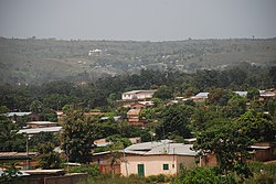
Djougou is the largest city in northwestern Benin. It is an important market town. The commune covers an area of 3,966 square kilometres and as of 2002 had a population of 181,895 people.
Boukoumbé or Boukombé is a town, arrondissement and commune in north western Benin on the border with Togo. It is known for its market, its whipping ceremony and for its tradition of pipe making. Mount Kousso-Kovangou, the highest point in Benin, lies nearby.

The Pendjari National Park lies in north western Benin, adjoining the Arli National Park in Burkina Faso. Named for the Pendjari River, the national park is known for its wildlife and is home to some of the last populations of big game like the African forest elephant, lion, hippopotamus, African buffalo, and various antelopes in West Africa. The park is also famous for its richness in birds.

Donga is one of the twelve departments of Benin; its capital is Djougou, the fourth largest city in the country. The department of Donga was created in 1999 when it was split off from Atakora Department. Donga is subdivided into five communes, each centered at one of the principal towns: Bassila, Copargo, Djougou Rural, Djougou Urban and Ouaké.

Borgou is one of the twelve departments of Benin. Borgou borders the country of Nigeria and the departments of Alibori, Atakora, Collines and Donga. The capital of Borgou is Parakou. The department of Borgou was bifurcated in 1999, with its northern territory transferred to the newly created Alibori Department.
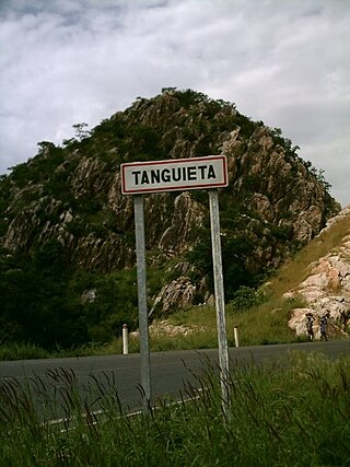
Tanguiéta is a town, arrondissement and commune located in the Atakora Department of Benin.The commune covers an area of 5465 square kilometres and as of 2013 had a population of 74,675 people. As of 2007 the town had an estimated population of 21,290. It lies on the RNIE 3 highway which connects it to Natitingou.
Christianity is the largest religion in Benin, with substantial populations of Muslims and adherents of traditional faiths. According to the most recent 2020 estimate, the population of Benin is 52.2% Catholic, 24.6% Muslim, 17.9 Animist and 5.3% follows other faiths or has no religion.
Cobly or Kobli is a town, arrondissement and commune in the Atakora Department of north-western Benin.
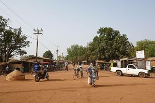
Biguina is a community or village in the commune of Bassila in the Donga Department of northwestern Benin. It is located near the border with Togo and it sits on Benin's Route Nationale 3, one of the two main north-south highways in the country.
Wateni is a rural commune in the Cercle of Sikasso in the Sikasso Region of southern Mali. The commune covers an area of 211 square kilometers and includes ten villages. In the 2009 census it had a population of 6,701. The village of N'Tjila, the administrative center (chef-lieu) of the commune, is 94 km west-northwest of Sikasso.
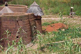
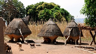
The Tammari people, also known as Batammariba, Tamberma, Somba, Otamari or Ottamari, are an Oti–Volta-speaking people of the Atakora Department of Benin where they are also known as Somba and neighboring areas of Togo, where they are officially known as Ta(m)berma. They are famous for their two-story fortified houses, known as Tata Somba, in which the ground floor houses livestock at night, internal alcoves are used for cooking, and the upper floor contains a rooftop courtyard that is used for drying grain, as well as containing sleeping quarters and granaries. These evolved by adding an enclosing roof to the clusters of huts, joined by a connecting wall that is typical of Gur-speaking areas of West Africa.
Tsaouni Tsouni is a rural commune in Niger, located in the Tillabéri Region, which is in the southwestern part of the country. The commune covers an area of approximately 1,457 square kilometers and has an estimated population of around 29,000 people. The main ethnic groups living in the area are the Hausa people, Dendi people, and Peulh.
Birni is a town and arrondissement in the Atakora Department of northwestern Benin near the border of Togo. It is an administrative division under the jurisdiction of the commune of Kouandé. According to the population census conducted by the Institut National de la Statistique Benin on February 15, 2002, the arrondissement had a total population of 12,559.

Kandi is a town, arrondissement and commune in the Alibori Department of eastern Benin. Originally a market town, Kandi is now primarily a farming centre. It lies on the nation's main north-south highway, 650 km (400 mi) from Cotonou and 523 km (325 mi) north of Porto-Novo. The town is the capital of the department of Alibori. The commune covers an area of 3,421 km2 (1,321 sq mi) and as of 2013 had a population of 177,683 people. The town itself had a population of 27,227 in 2002.
The Dendi are an ethnic group located in Benin, Niger, Nigeria and northern Togo mainly in the plains of the Niger River. They are part of the Songhai people. Derived from the Songhay language, the term "Dendi" translates to "down the river." The community consists of 195,633 people. Among them, only 4,505 live in Nigeria. In Niger they live in around the city of Gaya. Their mother tongue is Dendi.