
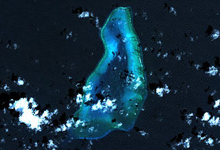
Diego Garcia is an island of the British Indian Ocean Territory, a disputed overseas territory of the United Kingdom also claimed by Mauritius. It is a militarised atoll just south of the equator in the central Indian Ocean, and the largest of the 60 small islands of the Chagos Archipelago. The Portuguese were the first Europeans to find it and it was then settled by the French in the 1790s and transferred to British rule after the Napoleonic Wars. It was one of the "Dependencies" of the British Colony of Mauritius until the Chagos Islands were detached for inclusion in the newly created British Indian Ocean Territory (BIOT) in 1965.

Aldabra is the world's second-largest coral atoll, lying southeast of the continent of Africa. It is part of the Aldabra Group of islands in the Indian Ocean that are part of the Outer Islands of the Seychelles, with a distance of 1,120 km (700 mi) southwest of the capital, Victoria on Mahé Island.

The Chagos Archipelago or Chagos Islands is a group of seven atolls comprising more than 60 islands in the Indian Ocean about 500 kilometres (310 mi) south of the Maldives archipelago. This chain of islands is the southernmost archipelago of the Chagos–Laccadive Ridge, a long submarine mountain range in the Indian Ocean. In its north are the Salomon Islands, Nelson's Island and Peros Banhos; towards its south-west are the Three Brothers, Eagle, Egmont and Danger Island(s); southeast of these is Diego Garcia, by far the largest island. All are low-lying atolls, save for a few extremely small instances, set around lagoons.
Peros Banhos, Pedro dos Banhos or Baixos de Pêro dos Banhos in old maps, is a formerly inhabited atoll in the Chagos Archipelago of the British Indian Ocean Territory, also claimed by Mauritius.

The Chagossians are an African ethnic group originating from French slaves brought to the Chagos Islands, specifically Diego Garcia, Peros Banhos, and the Salomon island chain, in the late 18th century. Most Chagossians now live in Mauritius and the United Kingdom after being forcibly removed by the British government in the late 1960s and early 1970s so that Diego Garcia, the island where most Chagossians lived, could serve as the location for a United States military base. Today, no Chagossians are allowed to live on the island of Diego Garcia, as it is now the site of the military base dubbed Camp Thunder Cove.
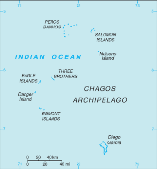
The British Indian Ocean Territory (BIOT) is an archipelago of 55 islands in the Indian Ocean, located south of India. It is situated approximately halfway between Africa and Indonesia. The islands form a semicircular group with an open sea towards the east. The largest, Diego Garcia, is located at the southern extreme end. It measures 60 square kilometres (23 sq mi) and accounts for almost three-quarters of the total land area of the territory. Diego Garcia is the only inhabited island and is home to the joint UK-US naval support facility. Other islands within the archipelago include Danger Island, Three Brothers Islands, Nelson Island, and Peros Banhos, as well as the island groups of the Egmont Islands, Eagle Islands, and the Salomon Islands.

The Three Brothers are a group of three small coral islands 20 kilometres east of Eagle Islands along the central western rim of the Great Chagos Bank, which is the world's largest coral atoll structure, located in the Chagos Archipelago.

Eagle Islands is a group of two islands in the Chagos Archipelago. They are located on the central-western rim of the Great Chagos Bank, which is the world's largest coral atoll structure.

Egmont Islands is an uninhabited atoll administered by the United Kingdom. They are one of the few emerged coral atolls that make up the Chagos Archipelago, British Indian Ocean Territory.
Blenheim Reef is a partly submerged atoll structure in the Chagos Archipelago, Indian Ocean. It includes the coral reef of Baxio Predassa in its southeastern rim, plus another completely submerged part. It is located in the northeastern part of the Chagos Archipelago. It measures almost eleven kilometres (north–south) by more than four kilometres (east–west), with a total area of 36.8 square kilometres, including the lagoon of 8.5 km², the difference being accounted for the mostly by the reef flat. Only on the eastern side, there are a few sand cays above the water. The largest of them is East Island, which is not quite 200 metres long and 70 metres wide. The other islands in the group are North, Middle and South. Only a few grasses grow on the island. The lagoon is up to 18 metres deep and encumbered with rock. The fringing coral reef has a wide passage in the southwest. The closest land is Takamaka Island in the Salomon Islands Atoll, about 20 kilometres to the southwest.
The Farquhar Atoll is part of the Farquhar Group of islands in the Seychelles that are part of the Outer Islands. It is located 770 kilometres southwest of the capital, Victoria, on Mahé Island.
The wildlife of Seychelles comprises the flora and fauna of the Seychelles islands off the eastern coast of Africa in the western Indian Ocean.

The British Indian Ocean Territory (BIOT) is an Overseas Territory of the United Kingdom situated in the Indian Ocean, halfway between Tanzania and Indonesia. The territory comprises the seven atolls of the Chagos Archipelago with over 1,000 individual islands – many very small – amounting to a total land area of 60 square kilometres. The largest and most southerly island is Diego Garcia, 27 square kilometres, the site of a Joint Military Facility of the United Kingdom and the United States. Official administration is remote from London, though the local capital is often regarded as being on Diego Garcia.

The Phoenix Islands Protected Area (PIPA) is located in the Republic of Kiribati, an ocean nation in the central Pacific approximately midway between Australia and Hawaii. PIPA constitutes 11.34% of Kiribati's exclusive economic zone (EEZ), and with a size of 408,250 km2 (157,630 sq mi), it is one of the largest marine protected areas (MPA) and one of the largest protected areas of any type on Earth. The PIPA was also designated as the world's largest and deepest UNESCO World Heritage Site in 2010.
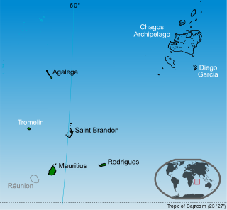
Sovereignty over the Chagos Archipelago is disputed between Mauritius and the United Kingdom. Mauritius has repeatedly stated that the Chagos Archipelago is part of its territory and that the United Kingdom claim is a violation of United Nations resolutions banning the dismemberment of colonial territories before independence.
Sea Cow Island, also known as Île Vache Marine, is a round 18 ha island on the Great Chagos Bank atoll of the Chagos Archipelago in the British Indian Ocean Territory.
The Chagos Marine Protected Area, located in the central Indian Ocean in the British Indian Ocean Territory of the United Kingdom, is one of the world's largest marine protected areas, and one of the largest protected areas of any type on Earth. It was established by the British government on 1 April 2010 as a massive, contiguous, no-take marine reserve, it encompasses 640,000 square kilometres (250,000 sq mi) of ocean waters, including roughly 70 small islands and seven atolls of the Chagos Archipelago.

The Maldives–Lakshadweep–Chagos Archipelago tropical moist forests is a tropical moist broadleaf forest ecoregion in South Asia. It spans a chain of coralline islands in the Indian Ocean, including Lakshadweep, a union territory of India; the Maldives, an independent country; and the British Indian Ocean Territory, an overseas territory of the United Kingdom.

