The House of Orsini is an Italian noble family that was one of the most influential princely families in medieval Italy and Renaissance Rome. Members of the Orsini family include five popes: Stephen II (752-757), Paul I (757-767), Celestine III (1191–1198), Nicholas III (1277–1280), and Benedict XIII (1724–1730). In addition, the family included 34 cardinals, numerous condottieri, and other significant political and religious figures.

Tivoli is a town and comune in Lazio, central Italy, about 30 kilometres east-north-east of Rome, at the falls of the Aniene river where it issues from the Sabine hills. The city offers a wide view over the Roman Campagna.
Cantalupo in Sabina is a town and comune in the province of Rieti, on the Sabine Hills of Lazio. It is famous as the reputed origin of the muskmelon called a cantaloupe melon.

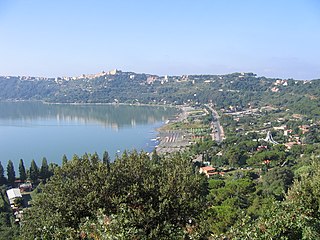
Trevignano Romano is a small town and comune in the Metropolitan City of Rome, Lazio, central Italy. With a population of about 5,000, it is located on the volcanic Lake Bracciano. It is about 47 kilometres (29 mi) away from Rome.
Antemnae was a town and Roman colony of ancient Latium in Italy. It was situated two miles north of ancient Rome on a hill commanding the confluence of the Aniene and the Tiber. It lay west of the later Via Salaria and now lies within a park in modern Rome.

Rieti is a town and comune in Lazio, central Italy, with a population of 47,700. It is the administrative seat of the province of Rieti and see of the diocese of Rieti, as well as the modern capital of the Sabina region.

Monterotondo is a town and comune in the Metropolitan City of Rome, central Italy.

Sabina, also called the Sabine Hills, is a region in central Italy. It is named after Sabina, the territory of the ancient Sabines, which was once bordered by Latium to the south, Picenum to the east, ancient Umbria to the north and Etruria to the west. It was separated from Umbria by the River Nar, today's Nera, and from Etruria by the River Tiber. Today, Sabina is mainly northeast of Rome in the regions Lazio, Umbria and Abruzzo. Upper Sabina is in the province of Rieti. Sabina Romana is in the province of Rome. Part of Sabina is in the regions of Umbria and Abruzzo.

Fiano Romano is a town and comune (municipality) in the Metropolitan City of Rome, Italy, approximately 40 kilometres (25 mi) north of that city.

Pacentro is a comune of 1,279 inhabitants of the province of L'Aquila in Abruzzo, Italy. It is a well-preserved historic medieval village located in central Italy, several kilometers from the City of Sulmona about 170 kilometres (110 mi) east of Rome. Pacentro has been nominated as one of the "Borghi più belli d'Italia".

Mentana is a town and comune, former bishopric and present Latin Catholic titular see in the Metropolitan City of Rome, Lazio, central Italy. It is located 29 kilometres (18 mi) north-east of Rome and has a population of about 23,000.

Gravina in Puglia is a town and comune of the Metropolitan City of Bari, Apulia, southern Italy.

Genzano di Roma is a town and comune in the Metropolitan City of Rome, in the Lazio region of central Italy. It is one of the Castelli Romani, at a distance of 29 kilometres (18 mi) from Rome, in the Alban Hills.
The so-called Roman Castles are a group of comunes in the Metropolitan City of Rome. They are located a short distance south-east of the city of Rome, at the feet of the Alban Hills, in the territory corresponding to the Old Latium.
San Severino Marche is a comune (municipality) in the Province of Macerata in the Italian region Marche, located about 50 kilometres (31 mi) southwest of Ancona and about 25 kilometres (16 mi) southwest of Macerata.

Arquata del Tronto is a comune (municipality) in the Province of Ascoli Piceno in the Marche region of Italy, located about 100 kilometres (62 mi) from Ancona. It is the only European municipality located partly within two natural parks: Gran Sasso national park and Cyblings mountains natural park.

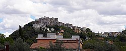
Fara in Sabina, also spelled Fara Sabina, is a comune (municipality) in the Province of Rieti in the Italian region Lazio, located about 40 kilometres (25 mi) northeast of Rome and about 25 kilometres (16 mi) southwest of Rieti.

Montelibretti is a town and comune (municipality) in the Metropolitan City of Rome in the Italian region Lazio, located about 30 kilometres (19 mi) northeast of Rome on the slopes of Monti Sabini.

Sacrofano is a comune (municipality) in the Metropolitan City of Rome in the Italian region Latium, located about 25 kilometres (16 mi) north of Rome. Located near the Monti Sabatini, at the feet of an extinct volcano, it is included in the Regional Park of Veii.
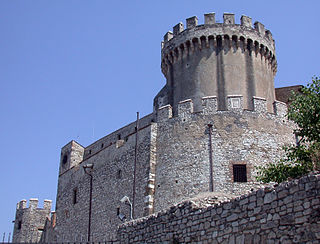
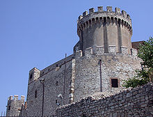
The Castello Orsini di Nerola or Castello di Nerola is a medieval, Romanesque-style castle situated atop a hill above the town of Nerola in the Province of Rome, Italy. The address is on via Aldo Bigelli. It now functions as a hotel and conference center.