Nettlecombe, Somerset

Last updated

Nettlecombe
NETTLECOMBE, Somerset - geograph.org.uk - 66189.jpg
Somerset UK location map.svg
Red pog.svg
Nettlecombe
Location within Somerset
Population174  [1]
OS grid reference ST057378
Civil parish
  • Nettlecombe
District
Shire county
Region
Country England
Sovereign state United Kingdom
Post town Taunton
Postcode district TA4
Dialling code 01984
Police Avon and Somerset
Fire Devon and Somerset
Ambulance South Western
UK Parliament
List of places
UK
England
Somerset
51°07′53″N3°20′54″W / 51.131468°N 3.348407°W / 51.131468; -3.348407 Coordinates: 51°07′53″N3°20′54″W / 51.131468°N 3.348407°W / 51.131468; -3.348407

Nettlecombe is a civil parish in the English county of Somerset. The parish covers a rural area below the Brendon Hills, comprising the small hamlets of Beggearn Huish, Torre, WoodfordYarde, together with more isolated individual farms and homes. In 2011, the parish had a population of 174. [1] [2]

Contents

The village takes its name from Nettlecombe Court, an Elizabethan manor house which was once the manorial centre of the area. [2]

There are no shops or other services within the parish, which is instead served by the nearby village of Williton. [2]

History

The manor was held before the Norman Conquest by Godwin, son of King Harold, and subsequently was the property of the crown. In 1160 it was granted to Hugh de Ralph and has never been sold since. It passed down through the family to John Trevelyan in 1481 and is still held by his successors. [3]

The parish of Nettlecombe was part of the Williton and Freemanners Hundred. [4]

Governance

Administratively, the civil parish falls within the Somerset West and Taunton local government district within the Somerset shire county, with administrative tasks shared between county, district and parish councils. [2]

The parish council has responsibility for local issues, including setting an annual precept (local rate) to cover the council's operating costs and producing annual accounts for public scrutiny. The parish council evaluates local planning applications and works with the local police, district council officers, and neighbourhood watch groups on matters of crime, security, and traffic. The parish council's role also includes initiating projects for the maintenance and repair of parish facilities, as well as consulting with the district council on the maintenance, repair, and improvement of highways, drainage, footpaths, public transport, and street cleaning. Conservation matters (including trees and listed buildings) and environmental issues are also the responsibility of the council.

The village falls within the non-metropolitan district of Somerset West and Taunton, which was established on 1 April 2019. It was previously in the district of West Somerset, which was formed on 1 April 1974 under the Local Government Act 1972, and part of Williton Rural District before that. [5] The district council is responsible for local planning and building control, local roads, council housing, environmental health, markets and fairs, refuse collection and recycling, cemeteries and crematoria, leisure services, parks, and tourism.

Somerset County Council is responsible for running the largest and most expensive local services such as education, social services, libraries, main roads, public transport, policing and fire services, trading standards, waste disposal and strategic planning.

It is also part of the Bridgwater and West Somerset county constituency represented in the House of Commons of the Parliament of the United Kingdom. It elects one member of parliament (MP) by the first past the post system of election.

Religious sites

The Church of St Mary the Virgin dates from the thirteenth and fourteenth centuries, with further alterations since. It lies within the grounds of Nettlecombe Court, and has been designated as a grade I listed building. [2] [6]

Climate

Nettlecombe [7]
Climate chart (explanation)
J
F
M
A
M
J
J
A
S
O
N
D
 
 
118
 
 
8
2
 
 
84
 
 
8
2
 
 
79
 
 
11
3
 
 
70
 
 
13
4
 
 
67
 
 
16
7
 
 
56
 
 
19
9
 
 
61
 
 
21
11
 
 
67
 
 
21
11
 
 
76
 
 
18
9
 
 
117
 
 
15
7
 
 
115
 
 
11
4
 
 
123
 
 
9
2
Average max. and min. temperatures in °C
Precipitation totals in mm
Imperial conversion
JFMAMJJASOND
 
 
4.7
 
 
47
36
 
 
3.3
 
 
47
35
 
 
3.1
 
 
51
38
 
 
2.7
 
 
55
39
 
 
2.6
 
 
61
44
 
 
2.2
 
 
66
49
 
 
2.4
 
 
70
52
 
 
2.6
 
 
69
52
 
 
3
 
 
65
49
 
 
4.6
 
 
58
45
 
 
4.5
 
 
52
40
 
 
4.8
 
 
47
36
Average max. and min. temperatures in °F
Precipitation totals in inches

Along with the rest of South West England, Nettlecombe has a temperate climate which is generally wetter and milder than the rest of England. The annual mean temperature is about 10 °C (50 °F) with seasonal and diurnal variations, but due to the modifying effect of the sea, the range is less than in most other parts of the United Kingdom. January is the coldest month with mean minimum temperatures between 1 and 2 °C (34 and 36 °F). July and August are the warmest months in the region with mean daily maxima around 21 °C (70 °F). In general, December is the dullest month and June the sunniest. The south west of England enjoys a favoured location, particularly in summer, when the Azores High extends its influence north-eastwards towards the UK. [8]

Cloud often forms inland, especially near hills, and reduces exposure to sunshine. The average annual sunshine totals around 1,600 hours. Rainfall tends to be associated with Atlantic depressions or with convection. In summer, convection caused by solar surface heating sometimes forms shower clouds and a large proportion of the annual precipitation falls from showers and thunderstorms at this time of year. Average rainfall is around 800–900 mm (31–35 in). About 8–15 days of snowfall is typical. November to March have the highest mean wind speeds, with June to August having the lightest. The predominant wind direction is from the south-west. [8]

Related Research Articles

<span class="mw-page-title-main">Ilminster</span> Human settlement in England

Ilminster is a minster town and civil parish in the South Somerset district of Somerset, England, with a population of 5,808. Bypassed in 1988, the town now lies just east of the junction of the A303 and the A358. The parish includes the hamlet of Sea.

<span class="mw-page-title-main">Backwell</span> Village in Somerset, England

Backwell is a village and civil parish in the unitary authority of North Somerset and in 2011 had a population of 4,589. The village lies about 7 miles (11 km) southwest of Bristol, south of the A370 to Weston-super-Mare. The parish includes the hamlets of Backwell Common, Backwell Green and Backwell Farleigh, and the districts of Backwell West Town and Downside.

<span class="mw-page-title-main">Crewkerne</span> Human settlement in England

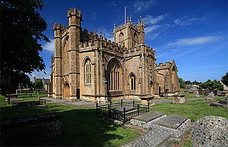
Crewkerne is a town and electoral ward in Somerset, England, 9 miles (14 km) southwest of Yeovil and 7 miles (11 km) east of Chard all in the South Somerset district. The civil parish of West Crewkerne includes the hamlets of Coombe, Woolminstone and Henley – and borders the county of Dorset to the south. The town is on the main headwater of the River Parrett, A30 road and West of England Main Line railway, in modern times the slower route between the capital and the southwest peninsula, having been eclipsed by the Taunton route.

<span class="mw-page-title-main">Dunster</span> Human settlement in England

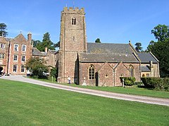
Dunster is a village and civil parish in Somerset, England, within the north-eastern boundary of Exmoor National Park. It lies on the Bristol Channel 2.5 miles (4 km) southeast of Minehead and 20 miles (32 km) northwest of Taunton. At the 2011 Census, it had a population of 817.

<span class="mw-page-title-main">Comeytrowe</span> Human settlement in England

Comeytrowe is a civil parish in Somerset, England, situated in the south western suburbs of Taunton in the Somerset West and Taunton district. The parish has a population of 5,463. The parish includes the area of Galmington.

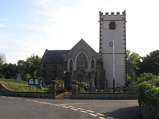
Williton is a large village and civil parish in Somerset, England, at the junction of the A39, A358 and B3191 roads, on the coast 2 miles (3.2 km) south of Watchet between Minehead, Bridgwater and Taunton in the now-defunct Somerset West and Taunton district.

<span class="mw-page-title-main">Nunney</span> Human settlement in England

Nunney is a village and civil parish in the Mendip local government district within the English county of Somerset. It is located 3 miles (5 km) south-west of Frome and the parish includes the hamlet of Holwell.

<span class="mw-page-title-main">Isle Abbots</span> Human settlement in England

Isle Abbots is a village and civil parish in Somerset, England, around 7 miles (11.3 km) south-east of Taunton in the South Somerset district. The village had a population of 205 at the 2011 census.

<span class="mw-page-title-main">Bicknoller</span> Human settlement in England

Bicknoller is a village and civil parish on the western slopes of the Quantock Hills in the English county of Somerset.

<span class="mw-page-title-main">Newton St Loe</span> Human settlement in England

Newton St Loe is a small Somerset village and civil parish located close to the villages of Corston and Stanton Prior, between Bath and Bristol in England. The majority of the village is owned by the Duchy of Cornwall. The parish has a population of 681.

<span class="mw-page-title-main">Brompton Ralph</span> Human settlement in England

Brompton Ralph is a village and civil parish in the Somerset West and Taunton district of Somerset, England, about 11 miles (18 km) west of Taunton, and 3 miles (5 km) north of Wiveliscombe. It is in a wooded district at the eastern extremity of the Brendon Hills. According to the 2002 population estimates it had a population of 287.

<span class="mw-page-title-main">West Quantoxhead</span> Human settlement in England

West Quantoxhead is a small village and civil parish in the Somerset West and Taunton district of Somerset, England. It lies on the route of the Coleridge Way and on the A39 road at the foot of the Quantock Hills, 3 miles (5 km) from East Quantoxhead, 2.5 miles (4 km) from Williton and equidistant from Bridgwater and Taunton. The parish includes the hamlets of Weacombe and Lower Weacombe.

<span class="mw-page-title-main">Sampford Brett</span> Human settlement in England

Sampford Brett is a village and civil parish situated at the south-western edge of the Quantock Hills, Somerset, England, less than 1 mile (1.6 km) south of Williton, just off the A358 road to Taunton.

<span class="mw-page-title-main">Godney</span> Human settlement in England

Godney is a village and civil parish near Glastonbury on the River Sheppey on the Somerset Levels in the Mendip district of Somerset, England.

<span class="mw-page-title-main">Banwell</span> Human settlement in England

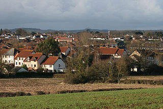
Banwell is a village and civil parish on the River Banwell in the North Somerset district of Somerset, England. Its population was 2,919 according to the 2011 census.

<span class="mw-page-title-main">Monksilver</span> Human settlement in England

Monksilver is a village 3 miles (5 km) west of the town of Williton in Somerset, England, on the eastern flank of the Brendon Hills and the border of the Exmoor National Park. The Coleridge Way footpath passes through the village.

<span class="mw-page-title-main">East Quantoxhead</span> Human settlement in England

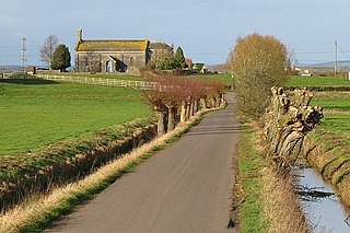
East Quantoxhead is a village in the district of Somerset West and Taunton, 3 miles (5 km) from West Quantoxhead, 4 miles (6 km) east of Williton, and 13 miles (21 km) west of Bridgwater, within the Quantock Hills Area of Outstanding Natural Beauty in Somerset, England.

<span class="mw-page-title-main">North Cadbury</span> Human settlement in England

North Cadbury is a village and civil parish 5 miles (8 km) west of Wincanton, by the River Cam, in the South Somerset district of Somerset, England. It shares its parish council with nearby Yarlington and its civil parish includes the village of Galhampton, which got its name from the settlement of the rent-paying peasants, and the hamlet of Woolston.

<span class="mw-page-title-main">Withycombe</span> Human settlement in England

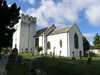
Withycombe is a village, civil parish, and former manor 2.5 miles (4 km) south east of Dunster, and 5 miles (8 km) from Minehead within the Exmoor National Park in the Somerset West and Taunton district of Somerset, England. The parish includes the village of Rodhuish. The manor house of the manor of Withycombe survives as Sandhill Farm.

<span class="mw-page-title-main">South Petherton</span> Village and civil parish in Somerset, England

South Petherton is a village and civil parish in the South Somerset district of Somerset, England, located 5 miles (8 km) east of Ilminster and 5 miles (8 km) north of Crewkerne. The parish had a population of 3,367 in 2011 and includes the smaller village of Over Stratton and the hamlets of Compton Durville, Drayton, Wigborough and Yeabridge. The River Parrett forms the eastern boundary of the parish. The village is approximately 2 miles (3 km) from East Lambrook, Martock and Lopen.

References

  1. 1 2 "Statistics for Wards, LSOAs and Parishes — SUMMARY Profiles" (Excel). Somerset Intelligence. Retrieved 4 January 2014.
  2. 1 2 3 4 5 "Welcome to Nettlecombe". Nettlecombe Parish Council. Retrieved 7 October 2008.
  3. Bush, Robin (1994). Somerset: The complete guide. Wimborne: The Dovecote Press Ltd. pp.  153–154. ISBN   1-874336-26-1.
  4. "Somerset Hundreds". GENUKI. Retrieved 23 October 2011.
  5. "Williton RD". A vision of Britain Through Time. University of Portsmouth. Retrieved 5 January 2014.
  6. Historic England. "Church of St Mary the Virgin (1173837)". National Heritage List for England . Retrieved 7 October 2008.
  7. "Nettlecombe 1981-2010 averages". Met Office. Archived from the original on 31 October 2012. Retrieved 24 November 2012.
  8. 1 2 "South West England: climate". Met Office. Archived from the original on 5 June 2011. Retrieved 14 March 2010.