
Buchan is a town in the east Gippsland region of Victoria, Australia. The town is situated adjacent to the Buchan River, in the Shire of East Gippsland, upstream from the river's junction with the Snowy River. At the 2011 census, Buchan and the surrounding area had a population of 385. The town is probably best known for the limestone Buchan Caves.
Devil's Lair is a single-chamber cave with a floor area of around 200 m2 (2,200 sq ft) that formed in a Quaternary dune limestone of the Leeuwin–Naturaliste Ridge, 5 km (3.1 mi) from the modern coastline of Western Australia. The stratigraphic sequence in the cave floor deposit consists of 660 cm (260 in) of sandy sediments, with more than 100 distinct layers, intercalated with flowstone and other indurated deposits. Excavations have been made in several areas of the cave floor. Since 1973, excavations have been concentrated in the middle of the cave, where 10 trenches have been dug. Archaeological evidence for intermittent human occupation extends down about 350 cm (140 in) to layer 30, with hearths, bone, and stone artefacts found throughout. The site provides evidence of human habitation of Southwest Australia 50,000 years before the present day.

The Buchan Caves are a group of limestone caves that include the Royal Cave and the Fairy Cave, located south-west of Buchan, in the East Gippsland region of the Australian state of Victoria. They have a total length of between 3 and 4 kilometres, and six entrances.

Cueva Fell or Fell'sCave is a natural cave and archaeological site in southern Patagonia. Cueva Fell is in proximity to the Pali Aike Crater, another significant archaeological site. Cueva Fell combined with the nearby Pali Aike site have been submitted to UNESCO as a possible World Heritage Site.

The Kow Swamp archaeological site comprises a series of late Pleistocene burials within the lunette of the eastern rim of a former lake known as Kow Swamp. The site is 10 kilometres (6 mi) south-east of Cohuna in the central Murray River valley, in northern Victoria, at 35.953553°S 144.318123°E. The site is significant for archaeological excavations by Alan Thorne between 1968 and 1972 which recovered the partial skeletal remains of more than 22 individuals.
The Keilor archaeological site was among the first places to demonstrate the antiquity of Aboriginal occupation of Australia when a cranium, unearthed in 1940, was found to be nearly 15,000 years old. Subsequent investigations of Pleistocene alluvial terraces revealed hearths about 31,000 years BP, making Keilor one of the earliest sites of human habitation in Australia. Remains of megafauna suggest a possible association with Aboriginal hunting.

Aboriginal sites of Victoria form an important record of human occupation for probably more than 40,000 years. They may be identified from archaeological remains, historical and ethnographic information or continuing oral traditions and encompass places where rituals and ceremonies were performed, occupation sites where people ate, slept and carried out their day to day chores, and ephemeral evidence of people passing through the landscape, such as a discarded axe head or isolated artefact.
The Mudgegonga rock shelter is a large rock overhang which contains over 400 Aboriginal wall paintings and stencils and evidence of prehistoric Aboriginal occupation. The site is located in north eastern Victoria near the town of Mudgegonga, and is associated with rich artefact deposits that shows occupation of the region by 3,500 years ago and may have been used several thousand years before this. It has been described as one of the richest rock art sites in Victoria.
The Tarragal Caves are a network of large limestone caves and rockshelters which overlook the Bridgewater Lakes near the towns of Tarragal and Cape Bridgewater, Victoria in the Charles La Trobe and are near Discovery Bay Coastal Park. The caves were identified as important Aboriginal camping places early in the historic period, and were excavated in the late 1970s by Harry Lourandos, revealing stratified deposits in the floor of 11,300 years old, along with shell midden deposits and earth ovens over 11,000 years old.
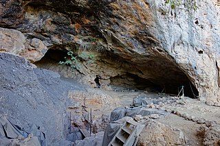
Cloggs Cave is a limestone cave and rockshelter with significant Aboriginal archaeological deposits, located on a cliff along the Snowy River gorge near the town of Buchan, Victoria.
Sandor (Alexander) Gallus was a Melbourne archaeologist, most famous for his investigations of Pleistocene Aboriginal occupation at Koonalda Cave in South Australia and the Dry Creek archaeological site in Keilor, Australia, which helped demonstrate the great antiquity of Aboriginal occupation of Australia.
The Buchan River is a perennial river of the Snowy River catchment, located in the Alpine region of the Australian state of Victoria.
Tham Lod Rockshelter, first researched by Rasmi Shoocongdej from Silpakorn University, funded by the Thai Research Fund, was a prehistoric cemetery and a workshop located in Northern Thailand known to have human inhabitants from the late Pleistocene to the late Holocene period Additionally, Tham Lod is near Ban Rai, another rock shelter and is in the vicinity of two well known caves, Spirit Cave and Tham Lot cave. Recent researches and carbon dating suggested that Homo sapiens have occupied the area. These researches provide more detail on the activities by the humans in the area which includes burials, living habits, gathering, and tool making, and social interactions.
Josephine Mary Flood, is an English-born Australian archaeologist, mountaineer, and author.
Kutikina Cave is a rock shelter located on the Franklin River in the South West Wilderness, a World Heritage Area in the Australian state of Tasmania.

The Mladečské Caves are a cave complex in the municipality of Mladeč in the Czech Republic. It is located in the Třesín National Nature Monument within the Litovelské Pomoraví Protected Landscape Area.
Taforalt or Grotte des Pigeons is a cave in the province of Berkane, Aït Iznasen region, Morocco, possibly the oldest cemetery in North Africa. It contained at least 34 Iberomaurusian adolescent and adult human skeletons, as well as younger ones, from the Upper Palaeolithic between 15,100 and 14,000 calendar years ago. There is archaeological evidence for Iberomaurusian occupation at the site between 23,200 and 12,600 calendar years ago, as well as evidence for Aterian occupation as old as 85,000 years.
Laang Spean refers to a prehistoric cave site on top of a limestone hill in Battambang Province, north-western Cambodia. The site's name Cave of Bridges hints to the many limestone arches that remain after the partial collapse of the cave's vault. Although excavations are still in progress, at least three distinct levels of ancient human occupation are already documented. At the site's deepest layers, around 5 meters below the ground, primitive flaked stone tools were unearthed, dating back to around 71,000 years BP. Of great interest are above layers that contain records of the Hoabinhian whose stratigraphic and chronological context has yet to be defined. Future excavations at Laang Spean might help to clarify the concept and "nature of the Hoabinhian" occupation and provide new data on the Pleistocene/Holocene transition in the region

Kilu Cave is a paleoanthropological site located on Buka Island in the Autonomous Region of Bougainville, Papua New Guinea. Kilu Cave is located at the base of a limestone cliff, 65 m (213 ft) from the modern coastline. With evidence for human occupation dating back to 30,000 years, Kilu Cave is the earliest known site for human occupation in the Solomon Islands archipelago. The site is the oldest proof of paleolithic people navigating the open ocean i.e. navigating without land in sight. To travel from Nissan island to Buka requires crossing of at least 60 kilometers of open sea. The presence of paleolithic people at Buka therefore is at the same time evidence for the oldest and the longest paleolithic sea travel known so far.
Madjedbebe is a sandstone rock shelter in Arnhem Land, in the Northern Territory of Australia, said to be the site of the oldest evidence of human habitation in the country. It is located about 50 kilometres (31 mi) from the coast. It is part of the lands traditionally inhabited by the Mirarr, an Aboriginal Australian clan of the Gaagudju people, of the Gunwinyguan language group. Although it is surrounded by the World Heritage Listed Kakadu National Park, Madjedbebe itself is located within the Jabiluka Mineral Leasehold.

