New Market, Alabama

Last updated

New Market, Alabama
New-Market-buildings-al1.jpg
Madison County Alabama Incorporated and Unincorporated areas New Market Highlighted.svg
Location in Madison County and the state of Alabama
Coordinates: 34°54′22″N86°25′34″W / 34.90611°N 86.42611°W / 34.90611; -86.42611
Country United States
State Alabama
County Madison
Area
[1]
  Total17.56 sq mi (45.48 km2)
  Land17.53 sq mi (45.40 km2)
  Water0.03 sq mi (0.08 km2)
Elevation
758 ft (231 m)
Population
 (2020) [2]
  Total1,543
  Density88.0/sq mi (33.98/km2)
Time zone UTC-6 (Central (CST))
  Summer (DST) UTC-5 (CDT)
ZIP code
35761
Area code 256
FIPS code 01-54312
GNIS feature ID0155175

New Market is an unincorporated community and census-designated place (CDP) in Madison County, Alabama, United States, and is included in the Huntsville-Decatur Combined Statistical Area. As of the 2020 census, the population of the CDP was 1,543. [2] Although it was the first area settled in Madison County, the town has never been incorporated.

Contents

History

In the early 19th century, several persons from Tennessee explored the area just across the border in what eventually became Madison County in Alabama. Isaac and Joseph Criner also explored the area and, in 1804, settled in the northern part near what is now called the Mountain Fork of the Flint River. George Smith, landowner of the town site, built the first log house and established a mercantile business in 1814. John Miller excavated a millrace and erected a gristmill and sawmill in 1819. Later settlers gave the name "New Market" to the community. [3]

On January 30, 1966, the coldest temperature ever to be recorded in Alabama was registered in New Market, at −27 °F (−33 °C).

Four sites in New Market are listed on the National Register of Historic Places: the New Market Historic District, New Market Presbyterian Church, New Market United Methodist Church, and the Whitman-Cobb House. [4] New Market is also home to the Mount Paran Cemetery, a historic cemetery recognized by the Alabama Register of Landmarks and Heritage and home to the graves of New Market pioneers including Isaac Criner and John Miller. [5]

Geography

New Market is located in northeastern Madison County at 34°54′23″N86°25′34″W / 34.90639°N 86.42611°W / 34.90639; -86.42611 (34.906295, -86.426170). [6] It is 17 miles (27 km) northeast of Huntsville and 6 miles (10 km) south of the Tennessee border.

According to the U.S. Census Bureau, the CDP has a total area of 17.6 square miles (45.5 km2), of which 0.03 square miles (0.08 km2), or 0.17%, are water. [1] The Mountain Fork of the Flint River flows through the northern part of the community. Backbone Mountain and other outliers at the southern end of the Cumberland Plateau rise 800 feet (240 m) above the town to the east.

Demographics

Historical population
CensusPop.Note
1880 144
1990 1,094
2000 1,86470.4%
2010 1,597−14.3%
2020 1,543−3.4%
U.S. Decennial Census

New Market first appeared on the 1880 U.S. Census as an unincorporated community of 144 residents. It did not appear again on the census for 110 years until 1990, when it was classified as a census-designated place (CDP).

2000 census

As of the census [7] of 2000, there were 1,864 people, 692 households, and 534 families residing in the CDP. The population density was 108.4 inhabitants per square mile (41.9/km2). There were 787 housing units at an average density of 45.8 units per square mile (17.7 units/km2). The racial makeup of the CDP was 87.18% White, 6.28% Black or African American, 2.25% Native American, 0.16% Asian, 1.34% from other races, and 2.79% from two or more races. 3.54% of the population were Hispanic or Latino of any race.

There were 692 households, out of which 38.0% had children under the age of 18 living with them, 61.7% were married couples living together, 10.8% had a female householder with no husband present, and 22.8% were non-families. 19.1% of all households were made up of individuals, and 6.8% had someone living alone who was 65 years of age or older. The average household size was 2.67 and the average family size was 3.05.

In the CDP, the population was spread out, with 26.1% under the age of 18, 8.3% from 18 to 24, 35.2% from 25 to 44, 19.5% from 45 to 64, and 10.9% who were 65 years of age or older. The median age was 35 years. For every 100 females, there were 101.3 males. For every 100 females age 18 and over, there were 101.3 males.

The median income for a household in the CDP was $42,985, and the median income for a family was $46,696. Males had a median income of $36,204 versus $18,188 for females. The per capita income for the CDP was $18,799. About 7.5% of families and 11.2% of the population were below the poverty line, including 14.7% of those under age 18 and 7.8% of those age 65 or over.

2010 census

As of the census [8] of 2010, there were 1,597 people, 632 households, and 454 families residing in the CDP. The population density was 91 people per square mile (35 people/km2). There were 714 housing units at an average density of 40.8 units per square mile (15.8 units/km2). The racial makeup of the CDP was 88.5% White, 6.7% Black or African American, 1.4% Native American, 0.2% Asian, 1.9% from other races, and 1.3% from two or more races. 4.4% of the population were Hispanic or Latino of any race.

There were 632 households, out of which 28.6% had children under the age of 18 living with them, 56.3% were married couples living together, 10.4% had a female householder with no husband present, and 28.2% were non-families. 23.6% of all households were made up of individuals, and 7.6% had someone living alone who was 65 years of age or older. The average household size was 2.53 and the average family size was 3.00.

In the CDP, the population was spread out, with 22.9% under the age of 18, 9.3% from 18 to 24, 24.3% from 25 to 44, 31.3% from 45 to 64, and 12.3% who were 65 years of age or older. The median age was 41.1 years. For every 100 females, there were 101.9 males. For every 100 females age 18 and over, there were 106.4 males.

The median income for a household in the CDP was $42,857, and the median income for a family was $51,250. Males had a median income of $36,250 versus $27,068 for females. The per capita income for the CDP was $22,043. About 11.9% of families and 14.6% of the population were below the poverty line, including 35.3% of those under age 18 and 21.1% of those age 65 or over.

2020 census

New Market racial composition [9]
RaceNum.Perc.
White (non-Hispanic)1,20978.35%
Black or African American (non-Hispanic)895.77%
Native American 291.88%
Asian 110.71%
Other/Mixed 1167.52%
Hispanic or Latino 895.77%

As of the 2020 United States census, there were 1,543 people, 475 households, and 369 families residing in the CDP.

Public services

Water service in the New Market area is run by the Madison County Water Authority. Sewer service is unavailable. Huntsville Utilities provides electric service.

The Madison County Sheriff's Department administers law and order in the community, and the New Market Volunteer Fire Department provides fire protection.

Education

New Market is home to several schools run by the Madison County Schools school district, which is the school district of New Market. [10]

K-8 schools

Middle schools

High schools

Notable people

Related Research Articles

<span class="mw-page-title-main">Morgan County, Alabama</span> County in Alabama, United States

Morgan County is a county in the north-central part of the U.S. state of Alabama. As of the 2020 census, its population was 123,421. The county seat is Decatur. On June 14, 1821, it was renamed in honor of American Revolutionary War General Daniel Morgan of Virginia. It is a prohibition or dry county, although alcohol sales are allowed in the cities of Decatur, Hartselle, and Priceville. Morgan County is included in the Decatur, AL Metropolitan Statistical Area, which is also included in the Huntsville-Decatur-Albertville, AL Combined Statistical Area. It is a part of the North, Northwest, and North-Central regions of Alabama.

<span class="mw-page-title-main">Limestone County, Alabama</span> County in the United States

Limestone County is a county of the U.S. state of Alabama. As of the 2020 census, the county's population was 103,570. Its county seat is Athens. The county is named after Limestone Creek. Limestone County is included in the Huntsville, AL Metropolitan Statistical Area.

<span class="mw-page-title-main">Madison County, Alabama</span> County in Alabama, United States

Madison County is located in the north central portion of the U.S. state of Alabama. As of the 2020 Census, the population was 388,153, making it the second-most populous county in Alabama. Its county seat is Huntsville. Since the mid-20th century it has become an area of defense and space research and industry.

<span class="mw-page-title-main">Marshall County, Alabama</span> County in Alabama, United States

Marshall County is a county of the state of Alabama, United States. As of the 2020 census the population was 97,612. Its county seat is Guntersville. A second courthouse is in Albertville. Its name is in honor of John Marshall, famous Chief Justice of the United States. Marshall County is a dry county, with the exception of the five cities of Albertville, Arab, Grant, Guntersville, and Boaz. Marshall County comprises the Albertville, AL Micropolitan Statistical Area, which is also included in the Huntsville-Decatur-Albertville, AL Combined Statistical Area.

Selmont-West Selmont is a census-designated place (CDP) in Dallas County, Alabama, United States. At the 2020 census, the population was 2,158.

<span class="mw-page-title-main">Edgewater, Alabama</span> CDP in Alabama, United States

Edgewater is a census-designated place in Jefferson County, Alabama, United States. It is northeast from the Birmingham suburb of Pleasant Grove. Its population was 883 at the 2010 census. This area was damaged by tornadoes on April 15, 1956 and April 8, 1998. The 1998 tornado was rated F5 on the Fujita scale.

<span class="mw-page-title-main">Ardmore, Alabama</span> Town in Alabama, United States

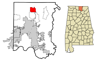
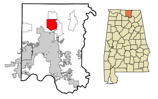
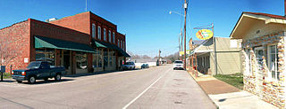
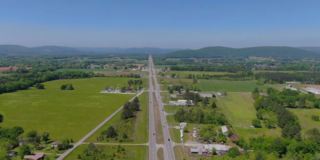
Ardmore is a town in Limestone County, Alabama, United States, and is included in the Huntsville-Decatur Metro Area. The population was 1,321 at the 2020 census, It borders its sister city Ardmore, Tennessee.

<span class="mw-page-title-main">Madison, Alabama</span> City in Alabama, United States

Madison is a city located primarily in Madison County, near the northern border of the U.S. state of Alabama. Madison extends west into neighboring Limestone County. The city is included in the Huntsville Metropolitan Area, the second-largest in the state, and is also included in the merged Huntsville-Decatur Combined Statistical Area. The population was 56,933 at the 2020 census. Madison is bordered by Huntsville on nearly all sides with some small unincorporated lands within Madison in Madison and Limestone counties.

<span class="mw-page-title-main">Gurley, Alabama</span> Town in Alabama, United States

Gurley is a town in Madison County, Alabama, United States, and is included in the Huntsville-Decatur Combined Statistical Area. As of the 2020 census, the population of the town was 816.

<span class="mw-page-title-main">Harvest, Alabama</span> Census-designated place in Alabama, United States

Harvest is an unincorporated community and census-designated place (CDP) in the northwestern part of Madison County, Alabama, United States, and is included in the Huntsville-Decatur Combined Statistical Area. According to the 2020 U.S. Census, the population of the community is 5,893.

<span class="mw-page-title-main">Hazel Green, Alabama</span> Census-designated place in Alabama, United States

Hazel Green is an unincorporated community and census-designated place (CDP) in Madison County, Alabama, United States, and is included in the Huntsville-Decatur Combined Statistical Area. As of the 2020 census, the population of the community was 4,105, up from 3,630 at the 2010 census.

<span class="mw-page-title-main">Meridianville, Alabama</span> Census-designated place in Alabama, United States

Meridianville is an unincorporated community and census-designated place (CDP) in Madison County, Alabama, United States, and is included in the Huntsville-Decatur Combined Statistical Area. As of the 2020 census, the population of the CDP was 8,209.

<span class="mw-page-title-main">Moores Mill, Alabama</span> Census-designated place in Alabama, United States

Moores Mill is an unincorporated community and census-designated place (CDP) in Madison County, Alabama, United States, and is included in the Huntsville-Decatur Combined Statistical Area. The population was 6,729 at the 2020 census, up from 5,682 at the 2010 census.

<span class="mw-page-title-main">New Hope, Alabama</span> City in Alabama, United States

New Hope is a city in Madison County, Alabama, United States, and is included in the Huntsville-Decatur Combined Statistical Area. The population was 2,889 at the 2020 census.

<span class="mw-page-title-main">Owens Cross Roads, Alabama</span> Town in Alabama, United States

Owens Cross Roads is a town in Madison County, Alabama, United States, and is included in the Huntsville-Decatur Combined Statistical Area. It was incorporated on October 9, 1967. The population was 2,594 at the 2020 census.

<span class="mw-page-title-main">Triana, Alabama</span> Town in Alabama, United States

Triana is a town in Madison County, Alabama, United States, and is included in the Huntsville-Decatur, AL Combined Statistical Area. The population was 2,890 at the 2020 census, and was estimated to be 3,961 in 2022.

<span class="mw-page-title-main">Theodore, Alabama</span> Census-designated place in Alabama, United States

Theodore is an unincorporated area and census-designated place (CDP) in Mobile County, Alabama, United States. The population was 6,270 at the 2020 census. It is a part of the Mobile metropolitan area. Prior to 1900 this area was known as "Clements", but it is now named for William Theodore Hieronymous, a sawmill operator and postmaster.

<span class="mw-page-title-main">Hartselle, Alabama</span> City in Alabama, United States

Hartselle is the second largest city in Morgan County, Alabama, United States, 13 miles (21 km) south of Decatur. It is part of the Decatur Metropolitan Area and the Huntsville-Decatur Combined Statistical Area.

<span class="mw-page-title-main">Mignon, Alabama</span> CDP in Alabama, United States

Mignon is a census-designated place (CDP) in Talladega County, Alabama, United States. At the 2020 census, the population was 1,186.

<span class="mw-page-title-main">Huntsville, Arkansas</span> City in Arkansas, United States

Huntsville is a city in and the county seat of Madison County, Arkansas, United States. The population was 2,879 at the 2020 census, up from 2,346 in 2010. During the American Civil War in 1862, it was the site of what became known as the Huntsville Massacre. Huntsville is part of the Northwest Arkansas region.

References

  1. 1 2 "2021 U.S. Gazetteer Files". United States Census Bureau. Retrieved April 6, 2022.
  2. 1 2 "New Market CDP, Alabama: 2020 DEC Redistricting Data (PL 94-171)". U.S. Census Bureau. Retrieved April 6, 2022.
  3. Taylor, James Jones; The History of Madison County, handwritten 1880-1886, transcribed and bound for the Huntsville-Madison County Library, 1940
  4. "National Register Information System". National Register of Historic Places . National Park Service. July 9, 2010. Retrieved July 15, 2014.
  5. "Mount Paran Campground and Cemetery". huntsvilleal.gov. City of Huntsville, AL. Retrieved March 1, 2021.
  6. "US Gazetteer files: 2010, 2000, and 1990". United States Census Bureau. February 12, 2011. Retrieved April 23, 2011.
  7. "U.S. Census website". United States Census Bureau . Retrieved January 31, 2008.
  8. "U.S. Census website". United States Census Bureau . Retrieved August 2, 2015.
  9. "Explore Census Data". data.census.gov. Retrieved December 17, 2021.
  10. "2020 CENSUS - SCHOOL DISTRICT REFERENCE MAP: Madison County, AL" (PDF). U.S. Census Bureau . Retrieved August 1, 2022. - Text list

34°54′23″N86°25′34″W / 34.906295°N 86.42617°W / 34.906295; -86.42617