
Sibley County is a county in the South Central part of the U.S. state of Minnesota. As of the 2020 census, the population was 14,836. Its county seat is Gaylord. Sibley County was part of the Minneapolis-St. Paul-Bloomington, MN-WI Metropolitan Statistical Area from 2013 to September 2018.

Scott County is a county in the U.S. state of Minnesota. As of the 2020 census, the population was 150,928. Its county seat is Shakopee. Shakopee is also the largest city in Scott County, the twenty-third-largest city in Minnesota, and the sixteenth-largest Twin Cities suburb. The county was organized in 1853 and named in honor of General Winfield Scott. Scott County is part of the Minneapolis-St. Paul-Bloomington, MN-WI Metropolitan Statistical Area. It is a member of the Metropolitan Council, and shares many of the council's concerns about responsible growth management, advocating for progressive development concepts such as clustering, open-space design, and the preservation of open space and rural/agricultural land.

Kandiyohi County is a county in the U.S. state of Minnesota. As of the 2020 census, its population is 43,732. As of November 20, 1871, its county seat is Willmar.

Dakota County is the third-most populous county in the U.S. state of Minnesota, located in the east central portion of the state. As of the 2020 census, the population was 439,882. The population of Dakota County was estimated to be 443,341 in 2022. The county seat is Hastings. Dakota County is named for the Dakota Sioux tribal bands who inhabited the area.
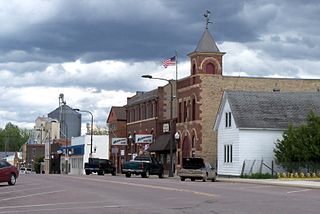
Arlington is a city in Sibley County, Minnesota, United States. The population was 2,233 at the 2010 census.
Arlington Township is a township in Sibley County, Minnesota, United States. The population was 562 at the 2000 census.
Green Isle Township is a township in Sibley County, Minnesota, United States. The population was 556 at the 2000 census.

The Mississippi National River and Recreation Area is a 72-mile (116 km) and 54,000-acre (22,000 ha) protected corridor along the Mississippi River through the Minneapolis–Saint Paul metro in the U.S. state of Minnesota, from the cities of Dayton and Ramsey, to just downstream of Hastings. This stretch of the upper Mississippi River includes natural, historical, recreational, cultural, scenic, scientific, and economic resources of national significance. This area is the only national park site dedicated exclusively to the Mississippi River. The Mississippi National River and Recreation Area is sometimes abbreviated as MNRRA or MISS, the four letter code assigned to the area by the National Park Service. The Mississippi National River and Recreation Area is classified as one of four national rivers in the United States, and despite its name it is technically not one of the 40 national recreation areas.

The Dakota War of 1862, also known as the Sioux Uprising, the Dakota Uprising, the Sioux Outbreak of 1862, the Dakota Conflict, the U.S.-Dakota War of 1862, or Little Crow's War, was an armed conflict between the United States and several bands of eastern Dakota also known as the Santee Sioux. It began on August 18, 1862, at the Lower Sioux Agency along the Minnesota River in southwest Minnesota.
Douglas is an unincorporated community in Olmsted County, Minnesota, United States. The community is located along 75th Street NW near its junction with County Road 3. Douglas is located within Kalmar Township and New Haven Township. Nearby places include Oronoco, Rochester, and the Douglas State Trail. The community is about two miles from the city of Rochester.
Markham is an unincorporated community in Colvin Township, Saint Louis County, Minnesota, United States.
Fairbanks is an unincorporated community in Fairbanks Township, Saint Louis County, Minnesota, United States; located within the Superior National Forest.
Moland is an unincorporated community in Rice and Steele counties in the U.S. state of Minnesota.
Pine Creek is an unincorporated community in Houston and Winona counties in the U.S. state of Minnesota.

Veseli is an unincorporated community in Wheatland Township, Rice County, Minnesota, United States. The community was incorporated in 1889. It was named after Veselí nad Lužnicí, in the Czech Republic, a city whence its early settlers came. Veseli was one of the four largest communities in Minnesota originally settled by Czech immigrants.

Assumption is an unincorporated community in Carver and Sibley Counties, Minnesota, United States.
Henderson Station is an unincorporated community in Tyrone Township, Le Sueur County, Minnesota, United States. The community is also known as East Henderson. It is 1.3 mi (2.1 km) east of Henderson, and six miles north of Le Sueur.
Oster is an unincorporated community in Carver and Wright Counties, Minnesota, United States.
Rush River is an unincorporated community in Kelso Township, Sibley County, Minnesota, United States, near Le Sueur.
August B. Muller was an American farmer and politician.


