Map showing Morrell's reported location of the "New South Greenland" coast (1823, red line), and "Ross's Appearance" as reported by Sir James Clark Ross in 1841. The dotted line indicates the area of Captain Johnson's 1821 voyage.
New South Greenland, sometimes known as Morrell's Land, was an appearance of land recorded by the American captain Benjamin Morrell of the schoonerWasp in March 1823, during a sealing and exploration voyage in the Weddell Sea area of Antarctica. Morrell provided precise coordinates and a description of a coastline which he claimed to have sailed along for more than 300 miles (500km). Because the Weddell Sea area was so little visited and hard to navigate due to ice conditions, the alleged land was never properly investigated before its existence was emphatically disproven during Antarctic expeditions in the early 20th century.
At the time of Morrell's voyage, the geography of the then unnamed Weddell Sea and its surrounding coasts was almost entirely unknown, making the claimed sighting initially plausible. However, obvious errors in Morrell's voyage account and his general reputation as a fabulist created scepticism about the existence of this new land. In June 1912 the German explorer Wilhelm Filchner searched for but found no traces of land after his ship Deutschland became icebound in the Weddell Sea and drifted into the locality of Morrell's observation. A line sounding of the sea bottom revealed more than 5,000 feet (1,500m) of water, indicating no land in near proximity. Three years later, trapped in the same waters with his ship Endurance, Ernest Shackleton was able by similar means to confirm the land's implausibility.
Various explanations for Morrell's error have been suggested, including intentional deception. However, Morrell describes his find briefly and prosaically, evidently seeking no personal credit or glory from the discovery. In his narrative, he assigns the honour to his fellow sealing captain, Robert Johnson, for finding and naming the land two years earlier. Morrell may have been honestly mistaken, through miscalculation of his ship's position (the reported coastline does roughly match the shape of the nearest real one, but offset by a large distance) or by misremembering detail when writing the account after nine years. Alternatively, he may have made the common error of confusing distant icebergs with land, or been misled by the distorting effects of Antarctic mirage. In 1843 British naval explorer James Clark Ross reported possible land in a position close to Morrell's; this land, too, would eventually be proven not to exist.
Voyage of the Wasp, 1822–23
June 1822 to March 1823
In the early 19th century the geography of Antarctica was almost completely unknown, though occasional sightings of land had been recorded.[1] In 1822 Benjamin Morrell, who had sailed to the South Sandwich Islands the previous year,[2] was appointed commander of the schooner Wasp for a two-year voyage of sealing, trading and exploration in the Antarctic seas and the southern Pacific Ocean.[3] In addition to his sealing duties Morrell had, as he put it, "discretionary powers to prosecute new discoveries."[3] He proposed to use this discretion to investigate the Antarctic seas "and to ascertain the practicality... of penetrating to the South Pole."[3] This would be the first of four extended voyages that would keep Morrell at sea for most of the following eight years, although he would not revisit the Antarctic after the initial voyage.[4]
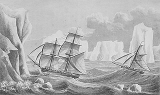
Wasp sailed south from New York on 22 June 1822. She reached the Falkland Islands late in October, after which Morrell spent 16 days in fruitless searches for the nonexistent Aurora Islands,[5][6] before heading for South Georgia, where the ship anchored on 20 November. In his account Morrell wrongly records the position of this anchorage, giving a location in open sea about 60 miles (100km) south-west of the island's coastline.[6] According to Morrell's account, Wasp then headed eastwards to hunt for seals, and reached the remote Bouvet Island on 6 December. The polar historian Hugh Robert Mill notes that Morrell's description of this island's physical features fails to mention its most singular characteristic—the permanent ice sheet that covers its surface.[7][8] Morrell then attempted to take the ship southwards but, reaching thick ice at around 60°S, turned northeast towards the Kerguelen Islands where he anchored on 31 December.[6][8]
Bouvet Island, which Morrell claimed to have reached on 6December 1822
After several days of exploration and evidently profitable sealing, Wasp left the Kerguelens on 11 January 1823, sailing south and east to record her furthest eastern position at 64°52'S, 118°27'E on 1 February.[9][10] From this point, according to his own account, Morrell decided to take advantage of strong easterly winds, and made passage westward back to the Greenwich meridian, 0°. His subsequent account of this voyage has been disputed, particularly his assertion that a distance of more than 3,500 miles (5,600km) was covered in 23days.[9] The writer Rupert Gould points out that, according to Morrell's record, this journey included a stretch of 900 miles (1,400km) in four days, a rate of progress that even Gould, generally sympathetic to Morrell, is inclined to doubt.[11] Morrell quotes various positions during the voyage at southerly latitudes which later proved to be at least 100miles inside the then undiscovered Antarctic continental mainland.[6][10] One possible explanation for this discrepancy, offered by the writer W.J. Mills, is that since Morrell's account was written nine years after the voyage he may not have had access to the ship's log, and hence "felt constrained to invent details that appeared plausible", in order to sustain his narrative.[6]
On 28 FebruaryWasp reached Candlemas Island in the South Sandwich Islands. After a few days spent in a search for fuel to feed the ship's stoves, Morrell sailed southwards on 6 March, into the area later known as the Weddell Sea.[6][12] Finding the sea remarkably free of ice, Morrell advanced to 70°14'S before turning north-westward on 14 March. This retreat, Morrell says, was due to the ship's lack of fuel; otherwise, he claims, in these open waters he could have taken the ship to 85°, or perhaps to the Pole itself.[13] These words are very similar to those used by the British explorer James Weddell to describe his own experiences in the same area, a month earlier, which has led historians to suspect that Morrell may have plagiarised Weddell's experiences.[14]
Sighting of land
Engraving of Benjamin Morrell from 1832
From the earliest navigations of the Southern Ocean in the 16th century, lands which subsequently proved to be nonexistent had from time to time been reported.[15] Robert Headland of the Scott Polar Research Institute has suggested various reasons for these false sightings, ranging from "too much rum" to deliberate hoaxes designed to lure rival ships away from good sealing grounds. Some sightings may have been of large ice masses that were carrying rocks and other glacial debris—dirty ice can appear convincingly similar to land. It is also possible that some of these lands existed, but later became submerged after volcanic eruptions. Other sightings may have been of actual land, the position of which was wrongly fixed through observational errors arising from chronometer failure, adverse weather or simple incompetence.[16]
At 2 pm on 15 March, as Wasp cruised north-eastwards, Morrell records: "Land was seen from the masthead, bearing west, distance 3 leagues" (about nine miles, 14km).[17] He did not at the time consider that he had made a new discovery; he seems to have assumed that he was seeing the east coast of the Antarctic Peninsula, the western coast of which had been explored and given the name New South Greenland in 1821, by Robert Johnson, a former captain of the Wasp.[6] Johnson's name for this land was never adopted; in 1831 it was named Graham Land.[18] At the time of Morrell's voyage, the geographical character and dimensions of the peninsula were unknown; Morrell's recorded position was in fact far to the east of the peninsula.[19] Morrell's account reads: "At half past 4 pm we were close on with the body of land to which Captain Johnson had given the name of New South Greenland".[17][20] The next few days were spent exploring this supposed coast, which was apparently rich in seal. Some 75 miles (120km) further south, Morrell thought he could see snow-covered mountains.[17]
After three days, Morrell called a halt "because of shortage of water and season far advanced".[17]Wasp turned north, from a position Morrell calculated as 67°52'S, 48°11'W, and on 19 March, the ship passed what he assumed was the northern cape of the land, at 62°41'S, 47°21'W. "This land abounds with oceanic birds of every description", wrote Morrell.[17] He also records seeing 3,000 sea elephants. At 10 o'clock Wasp "bade farewell to the cheerless shores of New South Greenland",[17] and sailed for Tierra del Fuego, then through the Magellan Strait into the Pacific Ocean, reaching Valparaiso, Chile, on 26 July 1823.[17]
Searches for Morrell's land
1894 maps of Antarctic regions showing the limited knowledge of Antarctic geography 70 years after Morrell. The lower map marks Ross's Appearance, but not New South Greenland
In 1838, the French explorer Jules Dumont d'Urville sailed over the position of Morrell's "north cape", but saw no indication of land.[21] This, together with the obvious errors in Morrell's voyage account, and his general reputation as a braggart, led most later geographers to doubt his story.[22] This scepticism remained even after Sir James Clark Ross reported an appearance of land in 1843, not far from Morrell's alleged observation; Ross's sighting was occasionally proffered as support for Morrell's claim.[21][23] After Ross there was no further exploration of the Weddell Sea until 1903, when William Speirs Bruce took Scotia to 74°1'S, but in a sector of the sea which did not bring him close to Morrell's or Ross's supposed sightings.[24] Bruce, however, did not dismiss Morrell's claims, writing that they should not be rejected until absolutely disproved.[25]
The first determined search for New South Greenland came during the Second German Antarctic Expedition, 1911–13, under Wilhelm Filchner. The expedition's ship, Deutschland, became trapped in heavy sea ice while attempting to establish a shore base at Vahsel Bay. Her subsequent north-westerly drift had, by mid-June 1912, brought her to a position just 37 miles (60km) east of Morrell's recorded sighting.[26] Filchner left the ship on 23 June and, with two companions and sufficient provisions for three weeks, sledged westward across the sea ice in search of Morrell's land. Daylight was limited to two or three hours a day, and temperatures fell to −35°C (−31°F), making travel difficult. They found no signs of land; a lead weight dropped through the ice reached a depth of 5,248 feet (1,600m) before the line snapped. The depth confirmed that there was no land in the vicinity, and Filchner concluded that Morrell had probably seen a mirage.[26]
On 17 August 1915 Sir Ernest Shackleton's ship Endurance, trapped in the ice like Deutschland three years earlier, drifted to a point 10miles west of Morrell's sighting. Here, a depth sounding recorded 1,676fathoms (10,060feet, 3,065m), leading Shackleton to write: "I decided that Morrell Land must be added to the long list of Antarctic islands and continental coasts that have resolved themselves into icebergs".[27] On 25 August a further sounding of 1,900fathoms (11,400feet, 3,500m) gave Shackleton additional evidence of the non-existence of New South Greenland.[27]
Although Filchner's and Shackleton's investigations and observations were accepted as conclusive proof that New South Greenland was a myth,[28] there remained the question of Sir James Ross's reported appearance of land in a position around 65°S, 47°W.[29] Ross's reputation was sufficient for this possibility to be taken seriously, and for his alleged sighting to be recorded on maps and Admiralty charts.[30] In 1922 Frank Wild, leading the Shackleton-Rowett Expedition aboard Quest after Shackleton's death early in the expedition, investigated the location of Ross's sighting. Nothing was seen; prevented by ice conditions from reaching the exact spot, Wild took a sounding at 64°11'S, 46°4'W, which revealed 2,331 fathoms (13,986ft; 4,263m) of water. This showed that no land was near.[31]
Opinions and theories
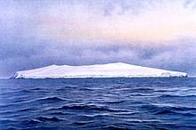
Weddell Sea iceberg in the region of "New South Greenland", Endurance expedition August1915. Shackleton observed how land appearances frequently resolved into icebergs.
Hugh Robert Mill, writing in 1905 before the non-existence of New South Greenland had been finally established, concluded that because of Morrell's blunders, and his habit of incorporating the experiences of others into his story, all his claims should be treated as unproven.[32] Nevertheless, he conceded that "a man may be ignorant, boastful and obscure, and yet have done a solid piece of work".[33] The Canadian geographer Paul Simpson-Housley, although sceptical about much of Morrell's account, suggests that the speeds claimed for the derided western journey, though fast, were not impossible,[34] and Morrell's farthest south in the Weddell Sea, queried by Mill,[35] is entirely plausible, given that James Weddell had sailed four degrees further south just a month earlier.[34]
The writer Rupert Gould, in a lengthy essay on New South Greenland published in 1929, queries the assumption that the sighting was simply invented by Morrell, partly on the grounds that very little weight is given to the discovery in Morrell's 500-page account. Gould writes: "If Morrell wished to gain an undeserved reputation as an Antarctic explorer, one would think he could have gone a better way about it than to bury his pièces justificatives, after he had forged them, in an undistinguished corner of so bulky a book."[36] Nor would he have credited it to Captain Johnson two years earlier, rather than to himself.[34]
The Larsen Ice Shelf, on the eastern coast of the Antarctic peninsula
Gould also discusses the possibility that what Morrell sighted was the eastern coast of Graham Land, the so-called "Foyn Coast",[37] despite its being 14° further west from position of the New South Greenland sighting. Gould asserts that the features of the peninsula's eastern coast corresponds closely with Morrell's description of New South Greenland.[38] This theory supposes that Morrell miscalculated the ship's position, perhaps because he lacked the chronometer necessary for proper navigational observation. In his account Morrell writes that he was "destitute of the various nautical and mathematical instruments",[39] although other parts of his narrative seem to indicate that the occasional dead reckoning calculation was the exception to the norm.[40] A longitudinal error of 14° is very large, and the additional distance of about 350 miles (560km) to the Foyn coast seems too great to have been covered within the ten-day voyage from the South Sandwich Islands, where the ship's position is recorded accurately.[34] Even so, Gould suggests that a "balance of evidence" shows that what Morrell saw was the Foyn coast.[41]
An example of a Fata Morgana, a form of superior mirage, which distorts ice or distant coastlines so they might appear as islands with tall cliffs.
Filchner's view that the supposed sighting of New South Greenland could be explained by a mirage is echoed by Simpson-Housley. He suggests that Morrell and his crew saw a superior mirage.[34] One form of superior mirage, sometimes described as a Fata Morgana, distorts distant flat coastlines or ice edges both vertically and horizontally, so they can appear to have tall cliffs and other features such as high mountain peaks and valleys.[42] In his expedition account South, Shackleton gives a description of a Fata Morgana observed on 20 August 1915, coincidentally as his ship Endurance drifted close to the recorded position of New South Greenland: "The distant pack is thrown up into towering barrier-like cliffs, which are reflected in blue lakes and lanes of water at their base. Great white and golden cities of Oriental appearance at close intervals along these cliff-tops indicate distant bergs... The lines rise and fall, tremble, dissipate, and reappear in an endless transformation scene".[27]
Afterwards
Morrell's four voyages finally ended on 21 August 1831, with his return to New York.[43] He then wrote his Narrative of Four Voyages, which was published the following year. He attempted to resume his seafaring career, seeking employment with the London-based shipping firm of Enderby Brothers, but his reputation had preceded him and he was rejected.[44] Charles Enderby stated publicly that "he had heard so much of him that he did not think fit to enter into any engagement with him."[45] Morrell also sought to join Dumont D'Urville's expedition to the Weddell Sea in 1837, but his services were again declined.[44] He reportedly died in 1839,[46] and is commemorated by Morrell Island, 59°27'S, 27°19'W, an alternative name for Thule Island in the Southern Thule sub-group of the South Sandwich Islands.[47] Robert Johnson, who coined the name New South Greenland, disappeared with his ship in 1826, while investigating the Antarctic waters in the vicinity of what would later be known as the Ross Sea.[44][48]
Notes
↑ For details of early Antarctic land sightings, including Bellingshausen's first sighting of the Antarctic mainland, see Headland, pp. 108–30
↑ The subsequent voyages, in successive ships, would take Morrell to the Pacific Ocean, the south and west coasts of Africa, and the Indian Ocean. See Morrell, Contents pages i to vii
↑ James Weddell, who first explored the area a month before Morrell, named the sea "King GeorgeIV's Sea". This name was not generally adopted; in 1900 the sea was formally named the Weddell Sea. Everett-Heath p. 409 (Weddell Sea entry)
↑ Gould uses the term "Foyn Coast" to describe the whole east coast of Graham Land. The Foyn Coast is actually only a short stretch of this coast, approximately 40 miles (64km) long, separated from the Weddell Sea by the Larsen Ice Shelf. See Stonehouse, p. 107
The history of Antarctica emerges from early Western theories of a vast continent, known as Terra Australis, believed to exist in the far south of the globe. The term Antarctic, referring to the opposite of the Arctic Circle, was coined by Marinus of Tyre in the 2nd century AD.
Sir Ernest Henry Shackleton was an Anglo-Irish Antarctic explorer who led three British expeditions to the Antarctic. He was one of the principal figures of the period known as the Heroic Age of Antarctic Exploration.
The Weddell Sea is part of the Southern Ocean and contains the Weddell Gyre. Its land boundaries are defined by the bay formed from the coasts of Coats Land and the Antarctic Peninsula. The easternmost point is Cape Norvegia at Princess Martha Coast, Queen Maud Land. To the east of Cape Norvegia is the King Haakon VII Sea. Much of the southern part of the sea is covered by a permanent, massive ice shelf field, the Filchner-Ronne Ice Shelf.
The Filchner–Ronne Ice Shelf or Ronne–Filchner Ice Shelf is an Antarctic ice shelf bordering the Weddell Sea.
James Weddell was a British sailor, navigator and seal hunter who in February 1823 sailed to latitude of 74° 15′ S—a record 7.69 degrees or 532 statute miles south of the Antarctic Circle—and into a region of the Southern Ocean that later became known as the Weddell Sea.
Wilhelm Filchner was a German army officer, scientist and explorer. He conducted several surveys and scientific investigations in China, Tibet and surrounding regions, and led the Second German Antarctic Expedition, 1911–13.
The voyage of the James Caird was a journey of 1,300 kilometres (800 mi) from Elephant Island in the South Shetland Islands through the Southern Ocean to South Georgia, undertaken by Sir Ernest Shackleton and five companions to obtain rescue for the main body of the stranded Imperial Trans-Antarctic Expedition of 1914–1917. Many historians regard the voyage of the crew in a 22.5-foot (6.9 m) ship's boat through the "Furious Fifties" as the greatest small-boat journey ever completed.
The Imperial Trans-Antarctic Expedition of 1914–1917 is considered to be the last major expedition of the Heroic Age of Antarctic Exploration. Conceived by Sir Ernest Shackleton, the expedition was an attempt to make the first land crossing of the Antarctic continent. After Roald Amundsen's South Pole expedition in 1911, this crossing remained, in Shackleton's words, the "one great main object of Antarctic journeyings". Shackleton's expedition failed to accomplish this objective but became recognized instead as an epic feat of endurance.
Vahsel Bay is a bay about 7 miles wide in the western part of the Luitpold Coast, Antarctica.
Carl Anton Larsen was a Norwegian-born whaler and Antarctic explorer who made important contributions to the exploration of Antarctica, the most significant being the first discovery of fossils for which he received the Back Grant from the Royal Geographical Society. In December 1893 he became the first person to ski in Antarctica on the Larsen Ice Shelf which was subsequently named after him. In 1904, Larsen re-founded a whaling settlement at Grytviken on the island of South Georgia. In 1910, after some years' residence on South Georgia, he renounced his Norwegian citizenship and took British citizenship. The Norwegian whale factory ship C.A. Larsen was named after him.
The Scottish National Antarctic Expedition (SNAE), 1902–1904, was organised and led by William Speirs Bruce, a natural scientist and former medical student from the University of Edinburgh. Although overshadowed in terms of prestige by Robert Falcon Scott's concurrent Discovery Expedition, the SNAE completed a full programme of exploration and scientific work. Its achievements included the establishment of a staffed meteorological station, the first in Antarctic territory, and the discovery of new land to the east of the Weddell Sea. Its large collection of biological and geological specimens, together with those from Bruce's earlier travels, led to the establishment of the Scottish Oceanographical Laboratory in 1906.
The Shackleton–Rowett Expedition (1921–22) was Sir Ernest Shackleton's last Antarctic project, and the final episode in the Heroic Age of Antarctic Exploration.
The Second German Antarctic Expedition of 1911–1913 was led by Wilhelm Filchner in the exploration ship Deutschland. Its principal objective was to determine whether the Antarctic continent comprised a single landmass rather than separated elements, and in particular whether the Weddell Sea and Ross Sea were connected by a strait. In addition, an extensive programme of scientific research was undertaken. The expedition failed to establish a land base, and the ship became beset in the Weddell Sea ice, drifting north for eight months before reaching open water. The expedition was marred by considerable disagreement and animosity among its participants, and broke up in disarray.
Farthest South refers to the most southerly latitude reached by explorers before the first successful expedition to the South Pole in 1911.
Benjamin Morrell was an American sea captain, explorer and trader who made a number of voyages, mainly to the Atlantic, the Southern Ocean and the Pacific Islands. In a ghost-written memoir, A Narrative of Four Voyages, which describes his sea-going life between 1823 and 1832, Morrell included numerous claims of discovery and achievement, many of which have been disputed by geographers and historians, and in some cases have been proven false. He ended his career as a fugitive, having wrecked his ship and misappropriated parts of the salvaged cargo.
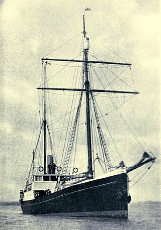
Quest was a low-powered, schooner-rigged steamship that sailed from 1917 until sinking in 1962, best known as the polar exploration vessel of the Shackleton–Rowett Expedition of 1921–1922. It was aboard this vessel that Sir Ernest Shackleton died on 5 January 1922 while in harbour in South Georgia. Prior to and after the Shackleton–Rowett Expedition, Quest operated in commercial service as a seal-hunting vessel or "sealer". Quest was also the primary expedition vessel of the British Arctic Air Route Expedition to the east coast of the island of Greenland in 1930–1931.
Ellsworth Scientific Station was a permanent, all year-round originally American, then Argentine Antarctic scientific research station named after American polar explorer Lincoln Ellsworth. It was located on Gould Bay, on the Filchner Ice Shelf.
Alexander John Henry Kerr was an English marine engineer and wholesale newsagent. He is best known for his service in the Imperial Trans-Antarctic Expedition of 1914–1916, for which he was awarded the Silver Polar Medal.
Felix König was an Austrian scientist, alpinist and Antarctic explorer. He was a member of Wilhelm Filchner's Second German Antarctic Expedition, 1911–13, which failed in its attempt to determine the nature of the link, if any, between the Weddell Sea and the Ross Sea, and thereby resolve the question as to whether the continent was a single landmass or a group of several elements. In the course of the expedition König, along with Filchner, was part of the group, that disproved the existence of the land known as New South Greenland, or "Morrell's Land", supposedly discovered in 1823 by the American sealer captain, Benjamin Morrell.
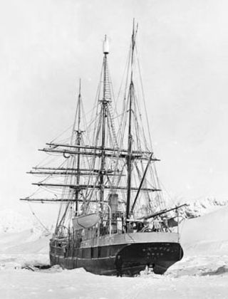
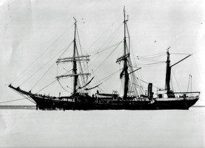
Deutschland, known as Bjørn between 1905 and 1909, and Osterreich between 1914 and 1917, was a Norwegian whaling and sealing ship, built in 1905. She is best known for her role as the expedition ship in the Second German Antarctic Expedition of 1911–13. During this expedition she was taken further south in the Weddell Sea than any previous vessel in those waters, but became trapped, surviving an eight-months long drift in heavy ice before being freed. After the expedition she was sold to Austria as the basis for another planned Antarctic expedition, but this was cancelled on the outbreak of the First World War in August 1914. The ship served in the Austro-Hungarian Navy as a minesweeper until 1917, when she was sunk in a torpedo attack.
References
Everett-Heath, John (2005). Concise Dictionary of World Place Names. Oxford: OUP. ISBN0-19-860537-4.
Gould, Rupert T. (1929). Enigmas. London: Philip Allan & Co. ISBN0-517-31081-3.
This page is based on this Wikipedia article Text is available under the CC BY-SA 4.0 license; additional terms may apply. Images, videos and audio are available under their respective licenses.