The Auckland Islands are an archipelago of New Zealand, lying 465 kilometres (290 mi) south of the South Island. The main Auckland Island, occupying 510 km2 (200 sq mi), is surrounded by smaller Adams Island, Enderby Island, Disappointment Island, Ewing Island, Rose Island, Dundas Island, and Green Island, with a combined area of 626 km2 (240 sq mi). The islands have no permanent human inhabitants.

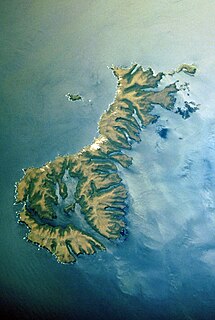
Macquarie Island is an island in the southwestern Pacific Ocean, about halfway between New Zealand and Antarctica. Regionally part of Oceania and politically a part of Tasmania, Australia, since 1900, it became a Tasmanian State Reserve in 1978 and was inscribed as a UNESCO World Heritage Site in 1997.
Auckland Island is the main island of the eponymous uninhabited archipelago in the Pacific Ocean. It is part of the New Zealand subantarctic area. It is inscribed in the UNESCO World Heritage list together with the other New Zealand Subantarctic Islands in the region.
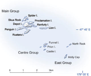
The Bounty Islands are a small group of 13 uninhabited granite islets and numerous rocks, with a combined area of 135 ha, in the South Pacific Ocean. Territorially part of New Zealand, they lie about 670 km (416 mi) east-south-east of New Zealand's South Island, 530 km (329 mi) south-west of the Chatham Islands, and 215 km (134 mi) north of the Antipodes Islands. The group is a World Heritage Site.

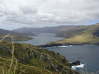
Campbell Island / Motu Ihupuku is an uninhabited subantarctic island of New Zealand, and the main island of the Campbell Island group. It covers 112.68 square kilometres (43.51 sq mi) of the group's 113.31 km2 (43.75 sq mi), and is surrounded by numerous stacks, rocks and islets like Dent Island, Folly Island, Isle de Jeanette-Marie, and Jacquemart Island, the latter being the southernmost extremity of New Zealand. The island is mountainous, rising to over 500 metres (1,640 ft) in the south. A long fjord, Perseverance Harbour, nearly bisects it, opening out to sea on the east coast.

The Snares Islands/Tini Heke, also known as The Snares, is a small group of uninhabited islands lying about 200 km south of New Zealand's South Island and to the south-southwest of Stewart Island. The Snares consist of the main North East Island and the smaller Broughton Island as well as the Western Chain Islands some 5 km (3.1 mi) to the west-southwest. Collectively, the Snares have a total land area of 3.5 km2 (1.4 sq mi).

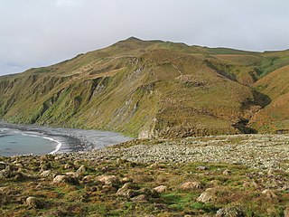
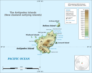
The Antipodes Islands are inhospitable and uninhabited volcanic islands in subantarctic waters to the south of – and territorially part of – New Zealand. The 21 km2 (8.1 sq mi) archipelago lies 860 kilometres (534 mi) to the southeast of Stewart Island/Rakiura, and 730 kilometres (454 mi) to the northeast of Campbell Island. They are very close to being the antipodal point to Normandy in France, meaning that the city furthest away from here is Cherbourg, France.
The Antipodes Subantarctic Islands tundra ecoregion, within the tundra biome, includes five remote island groups in the Pacific Ocean south of New Zealand: the Bounty Islands, Auckland Islands, Antipodes Islands and Campbell Island groups of New Zealand, and Macquarie Island of Australia.

The Campbell Islands are a group of subantarctic islands, belonging to New Zealand. They lie about 600 km south of Stewart Island. The islands have a total area of 113.31 km2 (43.75 sq mi), consisting of one big island, Campbell Island, and several small islets, notably Dent Island, Isle de Jeanette Marie, Folly Island, Jacquemart Island, and Monowai Island. Ecologically, they are part of the Antipodes Subantarctic Islands tundra ecoregion. The islands are one of five subantarctic island groups collectively designated as a World Heritage Site by UNESCO.

Enderby Island is part of the Auckland Islands archipelago, south of and belonging to New Zealand. It is situated just off the northern tip of Auckland Island, the largest island in the archipelago.

Ewing Island is an uninhabited island, part of the Auckland Islands group, a subantarctic chain that forms part of the New Zealand Outlying Islands. It lies in the north-east of the group, close to the mouth of Port Ross, immediately to the south of the larger Enderby Island and off the north-eastern tip of the main Auckland Island.

The Subantarctic snipe is a species of snipe endemic to New Zealand's subantarctic islands. The Maori call it "Tutukiwi". The nominate race C. a. aucklandica is found on the Auckland Islands. Other subspecies include C. a. meinertzhagenae from the Antipodes Islands, and C. a. perseverance from Campbell Island. The former subspecies from the Snares Islands has been separated as a full species, the Snares snipe, as have the extinct South Island and North Island snipes.

The Campbell Plateau is a large oceanic plateau south of New Zealand and the Chatham Rise. It originated in the Gondwanan breakup and is part of Zealandia, a largely submerged continent. The above sea level parts of the plateau — the Bounty Islands, Antipodes Islands, Auckland Islands and Campbell Island — form part of the New Zealand Subantarctic Islands which were declared a World Heritage Site in 1998. Large parts of the Campbell Plateau lie less than 1000 m below sea level. It rises to 500 m at the Pukaki Rise and emerges above sea level at the Auckland and Campbell Islands.
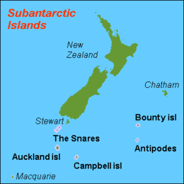
The New Zealand outlying islands comprise nine island groups, located in the subtropics and subantarctic, which are part of New Zealand but lie outside of the New Zealand continental shelf. Although considered as integral parts of New Zealand, seven of the nine island groups are not part of any region or district, but are instead designated as Area Outside Territorial Authority. The two exceptions are the Chatham Islands, which form a special territorial authority themselves, and the Solander Islands, which are part of the Southland Region and Southland District.
Insulantarctica is a biogeographic province of the Antarctic Realm according to the classification developed by Miklos Udvardy in 1975. It comprises scattered islands of the Southern Ocean, which show clear affinity to each other. These islands belong to different countries. Some of them constitute UNESCO's protected areas.
The austral snipes, also known as the New Zealand snipes or tutukiwi, are a genus, Coenocorypha, of tiny birds in the sandpiper family, which are now only found on New Zealand's outlying islands. There are currently three living species and six known extinct species, with the Subantarctic snipe having three subspecies, including the Campbell Island snipe discovered as recently as 1997. The genus was once distributed from Fiji, New Caledonia and Norfolk Island, across New Zealand and southwards into New Zealand's subantarctic islands, but predation by introduced species, especially rats, has drastically reduced their range.
Folly Island or the Folly Islands is a subantarctic island located in New Zealand's Campbell Island group.
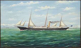
NZGSS Hinemoa was a 542-ton New Zealand Government Service Steamer designed specifically for lighthouse support and servicing, and also for patrolling New Zealand's coastline and carrying out castaway checks and searching for missing ships. It operated in New Zealand's territorial waters from 1876 to 1944.

The Sub-Antarctic Islands Scientific Expedition of 1907 was organised by the Philosophical Institute of Canterbury. The main aim of the expedition was to extend the magnetic survey of New Zealand by investigating Campbell Island and the Auckland Islands, but botanical, biological and zoological surveys were also conducted.
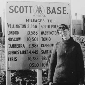
Marion Marie Stringer Darby was a New Zealand marine biologist and teacher. She was the first New Zealand woman to visit the Antarctic mainland. In January 1968, she travelled on the Magga Dan, the first tourist vessel to the Ross Sea, and visited Scott Base with other staff and tourists. She prepared a checklist of sub-Antarctic birds for the information of tourists on board and later wrote an article on summer seabirds to be seen between New Zealand and McMurdo Sound. Mt Darby in Antarctica is named after her.