Newbiggin may refer to several places in England:

Shap is a linear village and civil parish located among fells and isolated dales in Eden district, Cumbria, England, in the historic county of Westmorland. The parish had a population of 1,221 in 2001, increasing slightly to 1,264 at the 2011 Census.

Ainstable is a village and civil parish in the English county of Cumbria.

Ravenstonedale is a village and large civil parish in Cumbria, on the watershed between the River Lune and River Eden. The village lies 4 miles (6 km) south west of Kirkby Stephen. The parish includes the village of Newbiggin-on-Lune and several smaller settlements including Bowderdale, Brownber, Greenside, Stennerskeugh, Wath and Weasdale. Large areas of moorland lie within the parish, extending 5 miles (8 km) south west of the village to the northern side of the Howgill Fells. The parish had a population of 570 in 2001, increasing to 594 at the 2011 Census.
Bolton is a village and civil parish in the Eden District of Cumbria, England, about 4 miles (6 km) north west of Appleby-in-Westmorland, and on the River Eden. According to the census of 2001, it had a population of 416, increasing to 435 at the census of 2011. The parish touches Brougham, Colby, Cliburn, Crackenthorpe, King's Meaburn, Kirkby Thore, Morland and Temple Sowerby.
Brough Sowerby is a village and civil parish in the Eden district of Cumbria, England. It is located 22.3 miles south east of the town Penrith. According to the 2001 census it had a population of 127, increasing to 137 at the 2011 Census. The village is near the River Belah. 'A township in Brough parish, Westmoreland; 1½ mile S of Brough. Acres, 1,083. Real property with Kaber, £3,664. Pop., 140. Houses, 32.' There are quite a few Black Bull inns in the area surrounding Brough Sowerby, this comes from the old Scottish black cattle that were driven through Kirkby Stephen.

Yanwath and Eamont Bridge is a civil parish in the Eden District of Cumbria, England, consisting of the small village of Yanwath and most of the neighbouring village of Eamont Bridge. In the 2001 census it had a population of 457, increasing to 535 at the 2011 Census.
Dacre is a small village, civil parish and electoral ward in the Lake District National Park in the Eden District of Cumbria, England, and historically in Cumberland. In the 2001 census, the parish, which includes Newbiggin and Stainton, had a population of 1,326, increasing to 1,438 at the 2011 Census.

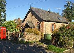
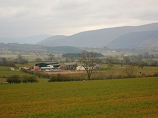
Newbiggin is a small village in Cumbria, North West England. It is in the Dacre civil parish about 3 mi (4.8 km) west of Penrith. It lies at 750 ft (230 m) sheltered from the prevailing south-westerly wind by Flusco Pike, 150 ft (46 m) higher. It is described as a "non-nucleated village," lying for a mile along either side of the C3019 between the A66 and the B5288. There are at least six other villages in Cumbria with the same name, which is derived from the Old English ‘new biggin', or new house. Locally this village is referred to as the "Stainton Newbiggin," to distinguish it from the others.

Temple Sowerby is a village and civil parish in Cumbria, northern England. It is close to the main east–west A66 road about 8 miles (13 km) east of Penrith in the Eden Valley. At the 2011 census Temple Sowerby was grouped with Newbiggin giving a total population of 528.

Hutton Roof is a village and civil parish in the South Lakeland district of Cumbria, England, close to Kirkby Lonsdale and Hutton Roof Crags. Historically in Westmorland, the parish includes the hamlet of Newbiggin. In the 2001 census the parish had a population of 193, increasing at the 2011 census to 218.

Newbiggin-on-Lune is a village in the Eden district of Cumbria, England. Historically in Westmorland it is about 4 miles (6.4 km) south west of Kirkby Stephen, and lies on the main A685 route from Brough to Tebay. Nearby to the north is located the Smardale Gill Viaduct on the dismantled former South Durham & Lancashire Union Railway between Tebay and Kirkby Stephen East railway station. To the south lies the Howgill Fells including Green Bell 1,985 feet.

Hoff is a hamlet and civil parish in the Eden district of the county of Cumbria, England. At the 2001 census the parish had a population of 189, decreasing marginally to 164 at the 2011 Census.
Morland is a village and civil parish in the rolling hills of the Eden Valley in the Eden District of Cumbria, England. It lies within the historic county of Westmorland. The parish includes the hamlets of Town Head and Morland Moor, and had a population of 380 in 2001, reducing marginally to 374 at the 2011 Census.

Colby is a village and civil parish in the Eden district of the English county of Cumbria. It is near the village of Bolton to the north and the town of Appleby-in-Westmorland to the east. At the 2001 census the parish had a population of 120, increasing to 129 at the 2011 Census.

Culgaith is a village and civil parish in the Eden district of Cumbria, England. It is located on the River Eden, between Temple Sowerby and Langwathby. At the 2001 census the parish had a population of 721, increasing to 826 at the 2011 Census.
Castle Sowerby is a civil parish in the Eden District of Cumbria, England. In 2001 it had a population of 337, increasing to 344 at the 2011 Census, and includes the hamlets of How Hill, Millhouse, Newlands, Sour Nook, Southernby and Sowerby Row.
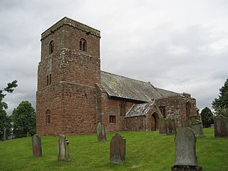
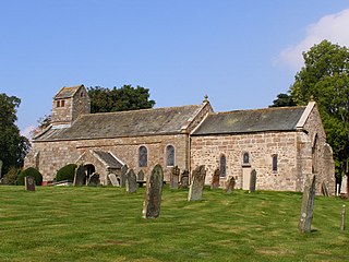
St Margaret and St James' Church is located about 0.5 miles (0.8 km) to the south of the village of Long Marton, Cumbria, England. It is an active Anglican parish church in the deanery of Appleby, the archdeaconry of Carlisle, and the diocese of Carlisle. Its benefice is united with those of ten local churches to form the benefice of Heart of Eden. The church is recorded in the National Heritage List for England as a designated Grade I listed building.