Related Research Articles

Union Park is a former baseball ground located in Baltimore, Maryland. The ground was home to the Baltimore Orioles during their first "glory years" in the 1890s. It was located in area bounded by East 25th Street to the north, 24th Street to the south Hunter Hunter Street to the west and Barclay Street to the east.

Bolton Hill is a neighborhood in Baltimore, Maryland, with 20 blocks of mostly preserved buildings from the late 19th century. It is listed on the National Register of Historic Places, preserved as a Baltimore City Historic District, and included within the boundaries of Baltimore National Heritage Area. The neighborhood is bounded by North Avenue, Mount Royal Avenue, Cathedral Street, Dolphin Street, and Eutaw Place. Bolton Hill is a largely residential neighborhood with three-story row houses with red brick, white marble steps, and high ceilings. There are also larger more ornate originally single-family houses, many houses of worship, parks, monuments, and a few large apartment buildings. Many significant residents have lived in the neighborhood, including F. Scott Fitzgerald, Woodrow Wilson, the Cone sisters, and Florence Rena Sabin.

Upton is a neighborhood in Baltimore City, Maryland, United States. The neighborhood is in the western section of the city, roughly between Fremont Avenue and McCulloh Street, extending from Dolphin Street to Bloom Street. Its principal thoroughfare is Pennsylvania Avenue.

Lutherville is a census-designated place (CDP) in Baltimore County, Maryland, United States. As of the 2010 census it had a population of 6,504. Prior to 2010 the area was part of the Lutherville-Timonium CDP. Within its borders lies the Lutherville Historic District.
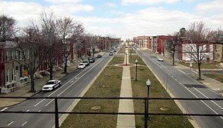
The Royal Theatre, located at 1329 Pennsylvania Avenue in Baltimore, Maryland, first opened in 1922 as the black-owned Douglass Theatre. It was the most famous theater along West Baltimore City's Pennsylvania Avenue, one of a circuit of five such theaters for black entertainment in big cities. Its sister theaters were the Apollo in Harlem, the Howard Theatre in Washington, D.C., the Regal Theatre in Chicago, and the Earl Theater in Philadelphia.
Madison Avenue Grounds was a baseball ground located in Baltimore, Maryland. It was built by the Waverly Club as the first enclosed ballpark in Baltimore, with spectator seating and player clubhouses, and was the site of the first intercity game played in Baltimore on September 22, 1860; it was the site of a 47-7 defeat of the local Marylands by the undefeated Cincinnati Red Stockings in 1869, and it was used by the Washington Olympics for a professional game in 1871. On August 16, 1870, it was the site of an intercity game between black teams. It would continue to be used for games staged by black teams, in a time before there were any organized Negro Leagues.
Belair Lot is a former baseball ground located in Baltimore, Maryland. The ground was home to the Baltimore Unions of the Union Association in 1884, with the exception of one game at the Madison Avenue Grounds. The ballpark was also called Union Park or Union Association Grounds.

Westport is a neighborhood in south Baltimore, Maryland. Westport is a majority African-American neighborhood that has struggled with crime, housing abandonment, and unemployment in the past decade. The neighborhood is bordered by the Middle Branch of the Patapsco River on the east, the city neighborhoods of Cherry Hill, Brooklyn and the southwestern Baltimore County community of Lansdowne to the southwest, Hollins Ferry Road and the Mount Winans and Lakeland neighborhoods to the west, and Interstate 95 to the north, along with the South Baltimore communities of Federal Hill and Otterbein. The Baltimore–Washington Parkway runs through the middle of Westport and intersects with Interstate 95, the main East Coast super-highway, north to south, Maine to Florida.
Bugle Field was a Baltimore based, predominantly wooden stadium utilized by the two primary Negro League teams of the 1916 to 1950 era, the Baltimore Black Sox, (1916-1933), and the Baltimore Elite Giants, (1938-1950). The Black Sox had a short tenure at the park, moving into the park permanently in 1932 before folding during the 1934 season. The Elite Giants were the park's primary tenants until its dismantlement during the 1949 Negro National League Championship Series. It was located on the northeast corner of Federal Street and Edison Highway, address 1601 Edison Highway. The site is in use today as the headquarters and local manufacturing plant of Rockland Industries, the first major corporation on record in Baltimore County, Maryland.
Oliver is a neighborhood in the Eastern district of Baltimore, Maryland. Its boundaries are the south side of North Avenue, the east side of Ensor Street, the west side of Broadway, and the north side of Biddle Street. This neighborhood, adjacent to Johns Hopkins Medical Campus and minutes from the Inner Harbor, lies east of the historic Greenmount Cemetery. The neighborhood is accessible by several bus lines, the Johns Hopkins metro station, Charm City Circulator, Pennsylvania Station (Baltimore), and freeway.

Dundalk High School (DHS) is a four-year public high school in the United States, located in Baltimore County, Maryland. The school opened in 1959. Starting in 2010, DHS was rebuilt and combined with Sollers Point Technical High School. The new building opened in 2013.
The Union Tunnel is a pair of railroad tunnels on Amtrak's Northeast Corridor in Baltimore, Maryland that connect Pennsylvania Station to the Pennsylvania Railroad's original mainline to Philadelphia, Pennsylvania and points north. The original tunnel was built in 1873, while a second one was completed in 1934.

Medfield is a neighborhood located in north Baltimore, Maryland, United States of America. It is located to the north of the trendy Hampden neighborhood and south of affluent Roland Park neighborhood. Its unofficial boundaries are Coldspring Lane to the north; Jones Falls Expressway to the west; Falls Road/Hickory Avenue to the east; and West 41st Street to the south.

Loudon Park Cemetery and Loudon Park Funeral Home, Inc. in Baltimore, Maryland, are locally owned and operated. Both the Cemetery and the Funeral Home became privately owned in 2014 when they were acquired from SCI. Loudon Park Funeral Home, Inc. was built on the grounds of the historic cemetery by Stewart Enterprises in 1995. SCI acquired Stewart Enterprises in 2013. The expanded cemetery was incorporated on January 27, 1853 on 100 acres of the site of the "Loudon" estate, previously owned by James Carey, a local merchant and politician. The entrance to the cemetery is located at 3620 Wilkens Avenue.

Oriole Park is the name of several former major league and minor league baseball parks in Baltimore, Maryland.
The Orchards is a neighborhood in the North District of Baltimore, located between the neighborhoods of New North Roland Park–Poplar Hill and Bellona–Gittings. Its boundaries are marked by the Baltimore County line (north), Maryland Route 133 Northern Parkway (south), and Maryland Route 139 Charles Street (east). Roland Avenue, West Lake Avenue, Kenmore Road and Melrose Avenue draw the neighborhood's west boundary.
Penn-North is a neighborhood in the city of Baltimore, Maryland, United States. It is located southwest of Druid Hill Park, west of Reservoir Hill, north of Bolton Hill, and east of Mondawmin. It is bounded Northeast by the Druid Park Lake Drive, the West and Northwest by Fulton Ave., the South by North Avenue, and East by McCulloh Street. It is contained in the 21217 ZIP code.

Bromo Arts District is one of three designated arts district in Baltimore, MD and is centered around the Emerson Bromo-Seltzer Tower, which houses artist studios. The district is roughly bounded by Park Avenue on the east, Lombard Street on the south, Paca Street on the west and Martin Luther King Jr. Boulevard and Read Street on the north and is adjacent to the neighborhoods of Mount Vernon and downtown Baltimore. It is home to the University of Maryland Medical Center, Lexington Market, Westminster Hall and Edgar Allan Poe's gravesite, the former Martick's Restaurant Francais and many cultural institutions including the Hippodrome Theatre, the Everyman Theatre, and the Eubie Blake National Jazz and Cultural Center. It is also home to A.T. Jones and Sons, the oldest costume company in the United States.
Oriole Park (V) is the name used by baseball historians to designate the longest-lasting of several former major league and minor league baseball parks in Baltimore, Maryland, each one named Oriole Park.
References
- ↑ Bready, James H. (1 October 1991). "Newington in the mist". Baltimore Sun. ISBN 0-8018-5833-X . Retrieved 18 June 2015.
- ↑ Bready, James H. (1998). Baseball in Baltimore: The First Hundred Years. Baltimore, Maryland, USA: Johns Hopkins University Press.
- ↑ "Your Baltimore Canaries: a very brief history of Baltimore's second professional base ball team". mdhs.org. Maryland Historical Society Library. 3 April 2013. Retrieved 18 June 2015.
Coordinates: 39°18′30″N76°38′25″W / 39.30833°N 76.64028°W
| This article about a baseball venue in Maryland is a stub. You can help Wikipedia by expanding it. |