
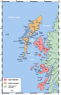
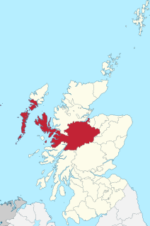
The Outer Hebrides or Western Isles, sometimes known as Na h-Innse Gall or the Long Isle/Long Island, is an island chain off the west coast of mainland Scotland. The islands are geographically coextensive with Comhairle nan Eilean Siar, one of the 32 unitary council areas of Scotland. They form part of the archipelago of the Hebrides, separated from the Scottish mainland and from the Inner Hebrides by the waters of the Minch, the Little Minch, and the Sea of the Hebrides. Scottish Gaelic is the predominant spoken language, although in a few areas English speakers form a majority.

Harris is the southern and more mountainous part of Lewis and Harris, the largest island in the Outer Hebrides, Scotland. Although not an island itself, Harris is often referred to as the Isle of Harris, which is the former postal county and the current post town for Royal Mail postcodes starting HS3 or HS5.

North Uist is an island and community in the Outer Hebrides of Scotland.

Benbecula is an island of the Outer Hebrides in the Atlantic Ocean off the west coast of Scotland. In the 2011 census, it had a resident population of 1,283 with a sizable percentage of Roman Catholics. It is in a zone administered by Comhairle nan Eilean Siar or the Western Isles Council.

Barra is an island in the Outer Hebrides, Scotland, and the second southernmost inhabited island there, after the adjacent island of Vatersay to which it is connected by a short causeway. The island is named after Saint Finbarr of Cork.
Eriskay, from the Old Norse for "Eric's Isle", is an island and community council area of the Outer Hebrides in northern Scotland with a population of 143, as of the 2011 census. It lies between South Uist and Barra and is connected to South Uist by a causeway which was opened in 2001. In the same year Ceann a' Ghàraidh in Eriskay became the ferry terminal for travelling between South Uist and Barra. The Caledonian MacBrayne vehicular ferry travels between Eriskay and Ardmore in Barra. The crossing takes around 40 minutes.
Berneray is an island and community in the Sound of Harris, Scotland. It is one of fifteen inhabited islands in the Outer Hebrides. It is famed for its rich and colourful history which has attracted much tourism. It lies within the South Lewis, Harris and North Uist National Scenic Area, one of 40 such areas in Scotland which are defined so as to identify areas of exceptional scenery and to ensure its protection from inappropriate development.
Barra Head, also known as Berneray, is the southernmost islands of the Outer Hebrides in Scotland. Within the Outer Hebrides, it forms part of the Barra Isles archipelago. Originally, Barra Head only referred to the southernmost headland of Berneray but is now a common name for the entire island. The highest point of the island is Sotan, a Marilyn.

Rodel is a village on the south-eastern coast of Harris, an island in the Scottish Outer Hebrides. Rodel is situated in the parish of Harris. It was historically the capital of Harris, and the main port, before Tarbert took the title.

Leverburgh (Scottish Gaelic: An t-Òb is the second largest village, after Tarbert, in Harris in the Outer Hebrides of Scotland. Leverburgh is within the parish of Harris. In 1971 it had a population of 223.
Balivanich is a village on the island of Benbecula in the Outer Hebrides off the west coast of Scotland. It is the main centre for Benbecula and the adjacent islands of North Uist, South Uist and several smaller islands. Balivanich is within the parish of South Uist.
The Minch, also called North Minch, is a strait in north-west Scotland, separating the north-west Highlands and the northern Inner Hebrides from Lewis and Harris in the Outer Hebrides. It was known as Skotlandsfjörð in Old Norse.

Carinish, is a hamlet on North Uist, in the Outer Hebrides, Scotland. It is in the south of the island, about two miles from the causeway to Benbecula. The hamlet is known for the Carinish Stone Circle and the Trinity Temple. Carinish is within the parish of North Uist and is situated on the A865.
Ceann a' Ghàraidh is the location of the ferry terminal on the south-western side of the island of Eriskay in the Outer Hebrides of Scotland. It provides a service across the Sound of Barra to Ardmore on the island of Barra The placename literally means "The head of the garden". This location is so called due to the presence of the old crofting boundary walls, which can no longer be seen.
Killegray is an island in the Sound of Harris in the Outer Hebrides of Scotland.

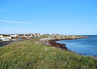
Calbost is a village on the Isle of Lewis in the Outer Hebrides, Scotland. Calbost is within the parish of Lochs, and within the district of Pairc.
Inverness-shire is a historic county, registration county and lieutenancy area of Scotland. Covering much of the Highlands and Outer Hebrides, it is Scotland's largest county, though one of the smallest in population, with 67,733 people or 1.34% of the Scottish population.
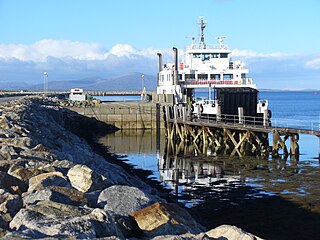
Otternish is the former North Uist terminal for the ferry to Berneray, in the Outer Hebrides, Scotland. The slipway lies 6 miles (10 km) north of Lochmaddy, and is situated within the parish of North Uist. Otternish is situated on the B893, and when the Berneray causeway was completed in December 1998, the slipway was no longer needed. Ancient human remains were found here in 1870. At a site 50 yards to the north of the discovery, a Viking ship burial was also found in the early 20th century.

Dun an Sticir is an Iron Age broch situated approximately 9.5 kilometers north of Lochmaddy in a loch on North Uist in the Scottish Outer Hebrides. A building was erected on the site in the late medieval period.

