Newtownabbey Borough Council

Last updated

Newtownabbey Borough
Newtownabbey in Northern Ireland.svg
Area151 km2 (58 sq mi) 
Ranked 22nd of 26
District HQ Newtownabbey
Catholic22.6%
Protestant67.8%
Country Northern Ireland
Sovereign state United Kingdom
Councillors
Website www.newtownabbey.gov.uk
List of places
UK
Northern Ireland
Floral sculpture on a roundabout in the borough showing a 3D representation of Newtownabbey Borough Council's logo Nbclogo roundabout.jpg
Floral sculpture on a roundabout in the borough showing a 3D representation of Newtownabbey Borough Council's logo

Newtownabbey Borough Council was a Local Authority in County Antrim in Northern Ireland, on the north shore of Belfast Lough just immediately north of Belfast. The Council merged with Antrim Borough Council in April 2015 under local government reform in Northern Ireland to form Antrim and Newtownabbey Borough Council.

Contents

History

Newtownabbey was founded in 1958 as a result of the Newtownabbey Urban District Act (Northern Ireland) 1957 [1] and comprises large urban residential areas along with traditional farming communities. Its major industries include electronics, software and telecommunications development and agriculture. Council headquarters were at Mossley Mill in Newtownabbey. Towns within the area included Ballyclare and Glengormley. The University of Ulster at Jordanstown is also in the area covered by the former Council.

The Newtownabbey Borough Council area consisted of four electoral areas: Antrim Line, Macedon, University, and Ballyclare. At the 2011 elections, 25 members were elected from the following political parties: 12 Democratic Unionist Party (DUP), 5 Ulster Unionist Party (UUP), 5 Alliance Party, 1 Social Democratic and Labour Party (SDLP) and 2 Sinn Féin. At the Annual General Meeting of the Council on the first Monday in June each year the Mayor was elected and became the first citizen of the Borough.

In elections for the Westminster Parliament it was split between the East Antrim constituency, the South Antrim constituency and the North Belfast constituency.

In May 2015 Newtownabbey Borough Council merged with Antrim Borough Council to form the new Antrim and Newtownabbey District Council.

Elections

When first created for the 1973 local elections, the council consisted of four electoral areas, named A, B, C and D, which elected 21 councillors. For the 1985 local elections, the number of electoral areas was increased to five: Manse Road, Doagh Road, Shore Road, Antrim Line and Ballyclare, each of which elected five councillors. Boundary changes again took effect for the 1993 local elections. The Doagh Road area, centred on Rathcoole was reduced from five to four wards. Consequently it gained the Whiteabbey and Cloughfern wards from the Shore Road district to form the new Macedon district. The Antrim Line district gained the Burnthill ward from the Manse Road district and the Mallusk ward from the Ballyclare district (which had gained a ward in the boundary changes.) The remaining seven wards of the Manse Road and Shore Road districts were combined to form the University district. In relation to the 1973–1981 districts, Ballyclare is similar to Area A, Macedon to Area B, University to Area C and Antrim Line to Area D.

Summary of seats won 1973–2011

1973197719811985198919931997200120052011
Ulster Unionist Party (UUP)98910111010965
Alliance (APNI)3632443125
Democratic Unionist Party (DUP)345965281212
Independent Unionist (IU)332243 1
Loyalist (Loy)21
Labour11111121
Unionist Party of Northern Ireland (UPNI)1
Independent (Ind)11
Social Democratic and Labour Party (SDLP)111211
Newtownabbey Ratepayers' Association (NRA)211
Ulster Democratic Party (UDP)11
Progressive Unionist Party (PUP)1
Sinn Féin (SF)112
United Unionist Coalition (UUC)11

Results for Labour are those for Robert Kidd and Mark Langhammer. Kidd was elected for the Northern Ireland Labour Party in 1973, as Independent Labour in 1977, for the Newtownabbey Labour Party in 1981, 1985 and 1997 and for Labour '87 in 1989. Langhammer was elected as Labour in 1993, 1997 and as an independent in 2001, though describing himself as "Labour" on the council website. [2]

Source: [3]

2011 Election results

Partyseatschange +/-
Democratic Unionist Party 12=
Ulster Unionist Party 5-1
Alliance Party of Northern Ireland 5+3
Sinn Féin 2+1
Social Democratic and Labour Party 1=
Newtownabbey Ratepayers Association 0-1
United Unionist Coalition 0-1
Independent 0-1

2005 Election results

Partyseatschange +/-
Democratic Unionist Party 12+4
Ulster Unionist Party 6-3
Alliance Party of Northern Ireland 2+1
Sinn Féin 1=
Social Democratic and Labour Party 1-1
Newtownabbey Ratepayers Association 1=
United Unionist Coalition 1=
Independent 1-1

Mayors

Review of Public Administration

Under the Review of Public Administration (RPA) the district was due to merge with Antrim Borough in 2011 to form a single council for the enlarged area totalling 572 km² and a population of 128,361. [4] The next election was due to take place in May 2009, but on 25 April 2008, Shaun Woodward, Secretary of State for Northern Ireland announced that the scheduled 2009 district council elections were to be postponed until the introduction of the eleven new councils in 2011. [5] On 1 April 2015 the new Antrim and Newtownabbey Borough Council took over responsibility for the area.

Population

The area covered by Newtownabbey Borough Council had a population of 85,139 residents according to the 2011 Northern Ireland census. [6]

See also

Related Research Articles

<span class="mw-page-title-main">Ballyclare</span> Town in County Antrim, Northern Ireland

Ballyclare is a small town in County Antrim, Northern Ireland. It had a population of 9,953 according to the 2011 census, and is located within the Antrim and Newtownabbey Borough Council area.

<span class="mw-page-title-main">Antrim (borough)</span> District of Northern Ireland (1973–2015)

Antrim was a local government district in Northern Ireland. It was one of twenty-six districts created in 1973, and was granted borough status on 9 May 1977. The borough covered an area of some 220 square miles (570 km2) and had a population of 53,428 according to the 2011 census. It was situated about 19 miles (31 km) north-west of Belfast. It bordered the north and east shores of Lough Neagh, the largest fresh water lake in the United Kingdom, and included the towns of Antrim, Toomebridge, Crumlin, Randalstown, Parkgate and Templepatrick. The council headquarters were located on the outskirts of Antrim town. Although the borough was not within the Belfast Metropolitan Area, it housed the city's international airport and many commuter villages.

<span class="mw-page-title-main">Fermanagh District Council</span> Human settlement in Northern Ireland

Fermanagh District Council was a local council in Northern Ireland. It was created out of Fermanagh County Council and later merged with Omagh District Council in April 2015 under local government reorganisation to become Fermanagh and Omagh District Council.

<span class="mw-page-title-main">South Antrim (UK Parliament constituency)</span> Parliamentary constituency in the United Kingdom, 1950 onwards

South Antrim is a parliamentary constituency in the United Kingdom House of Commons. The current MP is Paul Girvan of the Democratic Unionist Party.

<span class="mw-page-title-main">Belfast North (UK Parliament constituency)</span> Parliamentary constituency in the United Kingdom, 1885–1918 and since 1922

Belfast North is a parliamentary constituency in the United Kingdom House of Commons. The current MP is John Finucane of Sinn Féin.

<span class="mw-page-title-main">Larne Borough Council</span> Human settlement in Northern Ireland

Larne Borough Council was a Local Council in County Antrim in Northern Ireland. It merged with Ballymena Borough Council and Carrickfergus Borough Council in May 2015 under the reorganisation of local government in Northern Ireland to become Mid and East Antrim Borough Council.

<span class="mw-page-title-main">Lisburn City Council</span> Former city council in Counties Antrim and Down

Lisburn City Council was the local authority for an area partly in County Antrim and partly in County Down in Northern Ireland. As of May 2015 it was merged with Castlereagh Borough Council as part of the reform of local government in Northern Ireland to become Lisburn and Castlereagh City Council.

<span class="mw-page-title-main">Rathcoole (Newtownabbey)</span> Housing estate in Newtownabbey, Northern Ireland

Rathcoole is a housing estate in Newtownabbey, County Antrim, Northern Ireland. It was built in the 1950s to house many of those displaced by the demolition of inner city housing in Belfast city. Rathcoole is within the wider Antrim and Newtownabbey Borough. Its approximate borders are provided by O'Neill Road on the north, Doagh Road on the east, Shore Road on the south and Church Road and Merville Garden Village on the west.

William Alexander Fraser Agnew, known as Fraser Agnew, is a politician in Northern Ireland who was a Member of the Legislative Assembly (MLA) for Belfast North from 1998 to 2003.

Norman Boyd is a Unionist politician in Northern Ireland who served as a Member of the Northern Ireland Assembly (MLA) for South Antrim from 1998 to 2003.

Mark Langhammer is a Northern Irish trade unionist, employed as Director of the Association of Teachers and Lecturers and elected onto the Northern Ireland Committee of the Irish Congress of Trade Unions in 2008, being re-elected in 2010. A former politician in Northern Ireland, he was previously a prominent northern-based member of the Irish Labour Party.

Tommy Kirkham is a Northern Ireland loyalist political figure and former councillor. Beginning his political career with the Democratic Unionist Party, he was then associated with the Ulster Defence Association (UDA) and the Ulster Political Research Group although he has since been expelled from both groups. He was a former deputy mayor of Newtownabbey and sat on Newtownabbey Borough Council as an Independent Loyalist.

<span class="mw-page-title-main">Antrim and Newtownabbey Borough Council</span> Local authority in Northern Ireland

Antrim and Newtownabbey Borough Council is a local authority that was established on 1 April 2015. It replaces Antrim Borough Council and Newtownabbey Borough Council. A statutory transition committee was established in 2013 to prepare for the merger. The first elections to the authority were on 22 May 2014 with 73 candidates standing for 40 seats. The authority acted in shadow form until the formal creation of the Antrim and Newtownabbey district on 1 April 2015.

Antrim Borough Council was the local authority of Antrim in Northern Ireland. It merged with Newtownabbey Borough Council on 1 April 2015 under local government reorganisation in Northern Ireland to become Antrim and Newtownabbey Borough Council.

Ballymena Borough Council was the local authority of Ballymena in Northern Ireland. It merged with Carrickfergus Borough Council and Larne Borough Council in May 2015 under local government reorganisation in Northern Ireland to become Mid and East Antrim Borough Council.

Elections to Newtownabbey Borough Council were held on 5 May 2011 on the same day as the other Northern Irish local government elections. The election used four district electoral areas to elect a total of 25 councillors.

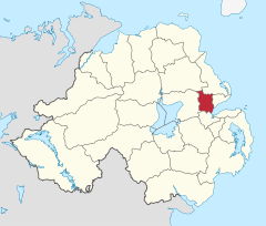
Ballyclare is one of the seven district electoral areas (DEA) in Antrim and Newtownabbey, Northern Ireland. The district elects five members to Antrim and Newtownabbey Borough Council and contains the wards of Ballyclare East, Ballyclare West, Ballynure, Ballyrobert and Doagh. Ballyclare forms part of the South Antrim constituencies for the Northern Ireland Assembly and UK Parliament.

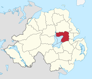
Macedon is one of the seven district electoral areas (DEA) in Antrim and Newtownabbey, Northern Ireland. The district elects six members to Antrim and Newtownabbey Borough Council and contains the wards of Abbey, Carnmoney Hill, O'Neill, Rathcoole, Valley and Whitehouse. Macedon forms part of the Belfast North constituencies for the Northern Ireland Assembly and UK Parliament and part of the East Antrim constituencies for the Northern Ireland Assembly and UK Parliament.

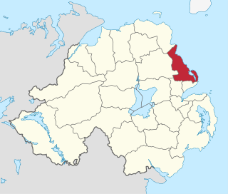
Antrim Line was one of the district electoral areas in Newtownabbey, Northern Ireland which existed from 1985 to 2014, one of five DEAs until 1993 and one of four DEAs until 2014. The district elected five members to Newtownabbey Borough Council until 1993 and seven members until 2014, and formed part of the South Antrim constituencies for the Northern Ireland Assembly and UK Parliament and part of the Belfast North constituencies for the Northern Ireland Assembly and UK Parliament.

Doagh Road was one of the five district electoral areas in Newtownabbey, Northern Ireland which existed from 1985 to 1993. The district elected five members to Newtownabbey Borough Council, and formed part of the South Antrim constituency for the Northern Ireland Assembly and South Antrim for the UK Parliament.

References

  1. "The Newtownabbey Urban District (Electoral Areas) Order (Northern Ireland) 1957". Legislation.co.uk. Retrieved 21 November 2021.
  2. see footnote on designations on the ARK website in the reference below
  3. Northern Ireland elections site, ARK, accessed 5 January 2012
  4. "Minister Foster announces decisions on Local Government Reform". DoE. Archived from the original on 18 July 2011. Retrieved 31 May 2008.
  5. Northern Ireland elections are postponed, BBC News, April 25, 2008, accessed April 27, 2008
  6. "NI Census 2011 - Key Statistics Summary Report, September 2014" (PDF). NI Statistics and Research Agency. Retrieved 28 September 2014.

54°39′25″N5°54′25″W / 54.65694°N 5.90694°W / 54.65694; -5.90694