
Larne is a town on the east coast of County Antrim, Northern Ireland, with a population of 18,853 at the 2021 census. It is a major passenger and freight roll-on roll-off port. Larne is administered by Mid and East Antrim Borough Council. Together with parts of the neighbouring districts of Antrim and Newtownabbey and Causeway Coast and Glens, it forms the East Antrim constituency for elections to the Westminster Parliament and Northern Ireland Assembly. The civil parish is in the historic barony of Glenarm Upper.

Warrenpoint is a small port town and civil parish in County Down, Northern Ireland. It sits at the head of Carlingford Lough, south of Newry, and is separated from the Republic of Ireland by a narrow strait. The town is beside the village of Rostrevor and is overlooked by the Mournes and Cooley Mountains. Warrenpoint sprang up within the townland of Ringmackilroy, and is locally nicknamed "The Point", which also represents the town's full name in Irish, An Pointe".

Armagh is the county town of County Armagh and a city in Northern Ireland, as well as a civil parish. It is the ecclesiastical capital of Ireland – the seat of the Archbishops of Armagh, the Primates of All Ireland for both the Roman Catholic Church and the Church of Ireland. In ancient times, nearby Navan Fort was a pagan ceremonial site and one of the great royal capitals of Gaelic Ireland. Today, Armagh is home to two cathedrals and the Armagh Observatory, and is known for its Georgian architecture.

Dromore is a town, townland and civil parish in County Tyrone, Northern Ireland. It is nine miles (14 km) south west of Omagh on the A32 and sixteen miles (26 km) from Enniskillen. The population of Dromore was 1,198 at the 2011 Census.

Dromore is a small market town and civil parish in County Down, Northern Ireland. It lies within the local government district of Armagh City, Banbridge and Craigavon. It is 19 miles (31 km) southwest of Belfast, on the A1 Belfast–Dublin road. The 2011 Census recorded a population of 6,395.

Cullyhanna is a small village and townland in County Armagh, Northern Ireland. The village extends further over the townlands of Tullynavall and Freeduff. It had a population of 306 in the 2001 Census. It is within the Newry and Mourne District Council area.

Loughgall is a small village, townland and civil parish in County Armagh, Northern Ireland. It is in the historic baronies of Armagh and Oneilland West. It had a population of 282 people in the 2011 Census. Loughgall was named after a small nearby loch. The village is surrounded by orchards.

Camlough is a village west of Newry in County Armagh, Northern Ireland. The village is named after a lake, known as the Cam Lough. South of the village is Camlough Mountain, part of the Ring of Gullion and is designated an Area of Outstanding Natural Beauty. Camlough had a population of 1,074 at the 2011 Census.

Castlecaulfield is a village in the south-east of County Tyrone in Northern Ireland. It lies about 2 miles west of Dungannon and is part of the Mid Ulster District Council area. The village is mostly within the townland of Drumreany, although part of it extends into Lisnamonaghan. It is situated in the historic Barony of Dungannon Middle and the civil parish of Donaghmore.

Ballymoyer or Ballymyre is a civil parish in the historic barony of Fews Upper, County Armagh, Northern Ireland, 3 miles north-east of Newtownhamilton.

Tynan is a village, townland and civil parish in County Armagh, Northern Ireland. It is situated largely in the historic barony of Tiranny, with some areas in the barony of Armagh, around 11 kilometres (7 mi) west of Armagh City.
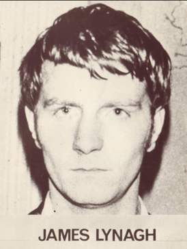
James 'Jim' Lynagh was a member of the East Tyrone Brigade of the Provisional Irish Republican Army (IRA), from Monaghan Town in the Republic of Ireland, who was killed by British special forces while attacking a police station.
Ballyscullion is a small village and civil parish in County Londonderry, Northern Ireland. In the 2001 Census it had a population of 291 people. The civil parish of Ballyscullion covers areas of County Antrim as well as County Londonderry. The village is situated within Mid-Ulster District.

Belleeks is a small village and townland in south County Armagh, Northern Ireland. In the 2011 Census it had a reported population of 375. It lies within the Newry, Mourne and Down District Council area and the historic barony of Upper Fews.

Cullaville or Culloville (from Irish Baile Mhic Cullach, meaning 'MacCullach's townland' or McCulloch's ville or town is a small village and townland near Crossmaglen in County Armagh, Northern Ireland. It is the southernmost settlement in the county and one of the southernmost in Northern Ireland, straddling the Irish border. In the 2001 Census it had a population of 400 people. The village is on a busy crossroads on the main Dundalk to Castleblaney road ; three of the roads lead across the border and the fourth leads to Crossmaglen.

Ballyronan is a village and townland in County Londonderry, Northern Ireland, on the north western shore of Lough Neagh. The village is 5 miles (8 km) from Magherafelt and 12 miles (19 km) from Cookstown. It is situated within Mid-Ulster District.
Dorsey or Dorsy is a small village and townland between Belleeks and Cullyhanna in County Armagh, Northern Ireland. It has an estimated population of 130-160 people and includes about 30-35 houses.
Ballymacnab is a townland and village in County Armagh, Northern Ireland. It is within the civil parish of Kilclooney, four miles south of the City of Armagh on the road towards Newtownhamilton. It is within the Armagh City and District Council area.

Banbridge is a town in County Down, Northern Ireland. It lies on the River Bann and the A1 road and is named after a bridge built over the River Bann in 1712. It is situated in the civil parish of Seapatrick and the historic barony of Iveagh Upper, Upper Half. The town began as a coaching stop on the road from Belfast to Dublin and thrived from Irish linen manufacturing. The town was home to the headquarters of the former Banbridge District Council. Following a reform of local government in Northern Ireland in 2015, Banbridge became part of Armagh City, Banbridge and Craigavon Borough Council. It had a population of 17,400 in the 2021 Census.

Poyntzpass is a small village on the border between southern County Armagh and County Down in Northern Ireland. It is situated in the civil parish of Ballymore and the historic barony of Orior Lower within the Armagh City, Banbridge and Craigavon area. It had a population of 552 people in the 2011 census. It was a part of the South Armagh constituency and is now part of the Newry and Armagh constituency.


