Related Research Articles

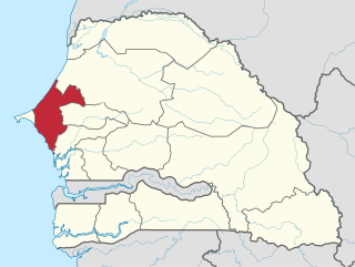
Senegal is a coastal West African nation located 14 degrees north of the equator and 14 degrees west of the Prime Meridian. The country's total area is 196,190 km2 of which 192,000 km2 is land and 4,190 km2 is water.

Mauritania, a country in the western region of the continent of Africa, is generally flat, its 1,030,700 square kilometres forming vast, arid plains broken by occasional ridges and clifflike outcroppings. Mauritania is the world’s largest country lying entirely below an altitude of 1,000 metres (3,300 ft). It borders the North Atlantic Ocean, between Senegal and Western Sahara, Mali and Algeria. It is considered part of both the Sahel and the Maghreb. A series of scarps face southwest, longitudinally bisecting these plains in the center of the country. The scarps also separate a series of sandstone plateaus, the highest of which is the Adrar Plateau, reaching an elevation of 500 metres or 1,640 feet. Spring-fed oases lie at the foot of some of the scarps. Isolated peaks, often rich in minerals, rise above the plateaus; the smaller peaks are called Guelbs and the larger ones Kedias. The concentric Guelb er Richat is a prominent feature of the north-central region. Kediet ej Jill, near the city of Zouîrât, has an elevation of 915 metres or 3,002 feet and is the highest peak.

The Lac de Guiers or Lake Guiers is a lake in northern Senegal, south of the city of Richard-Toll and in the Louga and Saint-Louis regions. It is a chief source of fresh water for the city of Dakar, hundreds of kilometers to the south-west, through underground pipes.
Thiès is a region of western Senegal. The capital is also called Thiès.

Saint Louis or Saint-Louis, known to locals as Ndar, is the capital of Senegal's Saint-Louis Region. Located in the northwest of Senegal, near the mouth of the Senegal River, and 320 km north of Senegal's capital city Dakar, it has a population officially estimated at 258,592 in 2021. Saint-Louis was the capital of the French colony of Senegal from 1673 until 1902 and French West Africa from 1895 until 1902, when the capital was moved to Dakar. From 1920 to 1957, it also served as the capital of the neighboring colony of Mauritania.
Point Calimere Wildlife and Bird Sanctuary (PCWBS) is a 21.47-square-kilometre (8.29 sq mi) protected area in Tamil Nadu, South India along the Palk Strait where it meets the Bay of Bengal at Point Calimere at the southeastern tip of Nagapattinam District. The sanctuary was created in 1967 for conservation of the least concern blackbuck antelope, an endemic mammal species of India. It is famous for large congregations of waterbirds, especially greater flamingos. International name: Point Calimere Wildlife Sanctuary, IBA Code: IN275, Criteria: A1, A4i, A4iii. The 7-square-kilometre (2.7 sq mi) core area of this sanctuary has been proposed as a National Park

The Sandhills, often written Sand Hills, is a region of mixed-grass prairie on grass-stabilized sand dunes in north-central Nebraska, covering just over one quarter of the state. The dunes were designated a National Natural Landmark in 1984.
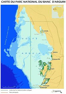
The Banc d'Arguin National Park of Bay of Arguin lies in Western Africa on the west coast of Mauritania between Nouakchott and Nouadhibou. The World Heritage Site is a major site for migratory birds and breeding birds, including flamingos, pelicans and terns. Much of the breeding is on sand banks including the islands of Tidra, Niroumi, Nair, Kijji and Arguim. The surrounding waters are some of the richest fishing waters in western Africa and serve as nesting grounds for the entire western region.

Spittal Pond Nature Reserve is the largest wildlife sanctuary in Bermuda, located close to the Atlantic coast of Smith's Parish. Surrounding the third largest pond in Bermuda, Spittal Pond, it covers an area of 60 acres (24 ha). It is one of 13 parks or reserves managed by the Bermuda Department of Conservation Services which protects and conserves environmentally critical areas and habitats. The pond reserve, a wetland site, is one of the seven Ramsar Sites in Bermuda, which was approved on 10 May 1999 for the criteria of its unique characteristics such as its lagoon which is permanently brackish, ecology featuring wet grassland and mangrove forests, seasonal shorebirds, other ver run waterbirds and European eels. It is also home to many types of species mostly including birds.

Lake Tsimanampetsotsa is a moderately alkaline lake in the Toliara Province, in the southwestern part of Madagascar. It is located at around 24°07′S43°45′E. The lake is protected within Tsimanampetsotsa National Park and it is also within a Ramsar site. The Ramsar site has a total area of 456 km2 (176 sq mi), while the surface of the lake is much smaller.
The Rann of Kutch Wildlife Sanctuary is the largest Ramsar site in Sindh, covering 566,375 ha, and is located in the Rann of Kutch in Badin District, Sindh, Pakistan. It was declared a wildlife sanctuary by the government of Sindh in 1980.

The Ferlo Desert, also known as the Ferio Desert, is a desert in northern-central Senegal. It is inhabited by the Serer and the Fulani.
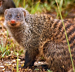
The wildlife of Senegal consists of the flora and fauna of this nation in West Africa. Senegal has a long Atlantic coastline and a range of habitat types, with a corresponding diversity of plants and animals. Senegal has 188 species of mammals and 674 species of bird.

Duinen van Texel National Park is a national park located on the North Holland island of Texel in the Netherlands. All dune systems on the western side of the island and the large coastal plains on both the northern and southern points of the island are part of the park. The park covers approximately 43 km2 (17 sq mi) and attained national park status in 2002. The visitor center is located in the natural history museum Ecomare.

The Guinean mangroves are a coastal ecoregion of mangrove swamps in rivers and estuaries near the ocean of West Africa from Senegal to Sierra Leone.
Akyatan Lagoon is a 14700-hectare wetland ecosystem that is designated as Wetland of International Importance by Ramsar Convention. A major stop over for migrating birds, Akyatan is recognized as an Important Bird Area by BirdLife International. It is the single largest green turtle rookery at the Mediterranean, holding 43% of the Mediterranean nesting population.
Lake Newland Conservation Park is a protected area in the Australian state of South Australia located on the west coast of the Eyre Peninsula about 10 kilometres (6.2 mi) north of the town of Elliston. It was proclaimed in 1991 in order to protect Lake Newland, a hypersaline lake, and an associated wetland complex. It lies in the traditional lands of the Wirangu people.
The wildlife of Bahrain is the flora and fauna of the archipelago of Bahrain, and is more varied than might be expected of this small group of islands in the Persian Gulf. Apart from a strip of the north and west of the main island, where crops such as potatoes are grown with irrigation, the land is arid. With a very hot dry summer, a mild winter, and brackish groundwater, the plants need adaptations in order to survive. Nevertheless, 196 species of higher plant have been recorded here, as well as about seventeen species of terrestrial mammals, many birds and reptiles, and many migratory birds visit the islands in autumn and spring.
Lake Düden, also known as Lake Kulu,, is a brackish water lake in Konya Province, Turkey.
References
- ↑ Philip's (1994). Atlas of the World. Reed International. p. 100. ISBN 0-540-05831-9.
- 1 2 3 4 "Niayes (from Dakar to St Louis)". BirdLife International. Retrieved 8 May 2019.
- ↑ "La sécheresse et la baisse du paludisme dans les Niayes du Sénégal]" (PDF). Cahiers d'études et de recherches francophones. 5 (5): 299–305. 1995.
- ↑ "Species profile: Casuarina equisetifolia". Global Invasive Species Database. IUCN. Retrieved 8 May 2019.