
The McMillin Bridge is a concrete half-through truss bridge crossing the Puyallup River, in Pierce County, Washington, built in 1934.

The Pittsburgh-Des Moines Steel Company, and often referred to as Pitt-Des Moines Steel or PDM was an American steel fabrication company. It operated from 1892 until approximately 2002 when its assets were sold to other companies, including Chicago Bridge & Iron Company. The company began as a builder of steel water tanks and bridges. It also later fabricated the "forked" columns for the World Trade Center in the 1960s, and was the steel fabricator and erector for the Gateway Arch in St. Louis. A number of its works are listed on the National Register of Historic Places.
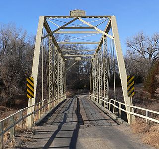
The Borman Bridge bringing a Cherry County, Nebraska road over the Niobrara River near Valentine, Nebraska was built in 1916, as a replacement for one of 18 Cherry County bridges washed away by flood and winter ice on February 16, 1916. It was designed by the Canton Bridge Co. of Canton, Ohio, fabricated by the Cambria Steel Co. of Johnstown, and built by the Canton Bridge Co.
The Piermont Bridge carries New Hampshire Route 25 over the Connecticut River to the contiguous Vermont Route 25 between Piermont, New Hampshire and Bradford, Vermont. It is a Pennsylvania steel through truss bridge, built by the Boston Bridge Works in 1928. The bridge consists of a single span with a clear span of 352' and an overall length of 354'10". The roadbed is 20'7" wide, with a vertical clearance of 14'7". The bridge is approximately 25' above the river. The western (Vermont) abutment is made of split granite quarried from nearby Fairlee Mountain, while the eastern abutment is an early concrete construction built in 1908 by John Storrs for an earlier bridge. The bridge underwent a major renovation in 1993 which included the addition of a sidewalk and replacement of much of the bridge decking.

The South Newfane Bridge is a historic bridge, carrying Parish Hill Road across the Rock River in the village of South Newfane, Vermont. It is a Pratt through truss span, manufactured from rolled I-beams in 1939 to replace a bridge washed away in flooding. It was listed on the National Register of Historic Places in 1992.
The Nishnabotna River Bridge is a Warren Pony truss bridge located southwest of Henderson, Iowa, United States. It spans the Nishnabotna River for 284 feet (87 m). The Warren Pony truss bridge was designed by engineers at the Iowa State Highway Commission in the summer of 1929. It was built by McCormack Construction Company of Lohrville, Iowa for $30,900, and completed in 1930. The bridge is made up of two skewed trusses that are supported by concrete abutments and piers. It was listed on the National Register of Historic Places in 1998.
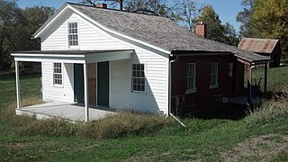
The Nishnabotna Ferry House is an historic building located in Lewis, Iowa, United States. The 1½ story, frame, Greek Revival structure was the home of Samuel Harlow Tefft who operated the cable ferry across the East Nishnabotna River from 1857 to 1859. The road that the ferry served was originally an Indian trail that became a primary route used by western bound emigrants, a stage coach and mail route, the Underground Railroad, a later Mormon Trail, and the Mormon handcart companies. The first ferry at this location was operated by Wm. S. Townsend in 1850. A toll bridge was built here 1853 or 1854. It became unstable by 1856. Tefft bought the property in 1857 in order to operate the ferry, and it is assumed that the house had already been built by that time. A new bridge was built by Cass County in 1859. Tefft and his wife remained in the community and are buried in Oakwood Cemetery at Lewis. Several different families lived in the house until the mid-1970s. It was listed on the National Register of Historic Places in 2001.
Yellow Smoke Park Bridge is located on the eastern edge of Denison, Iowa, United States. Steel was in short supply during World War II as a part of the war effort. Many bridges built across the state were built in this era with timber, especially small-scale bridges. Heavy flooding washed out 27 bridges and culverts in Crawford County in May 1945. The county board of supervisors used emergency funds to build new bridges. They bought several steel superstructures from the Des Moines Steel Company to replace the washed-out spans. The bowstring arch-truss structures appear to have been designed by H. Gene McKeown, a civil engineer from Council Bluffs. This bridge is one several similar structures built in the county, and one of five that still remain. It was moved to serve a pedestrian path in a county park around 1986. The bridge was listed on the National Register of Historic Places in 1998.

The Nishnabotna River Bridge is located southwest of Manilla, Iowa, United States. It carries traffic on 310th Street over the Nishnabotna River. Steel was in short supply during World War II as a part of the war effort. Many bridges built across the state were built in this era with timber, especially small-scale bridges. Heavy flooding washed out 27 bridges and culverts in Crawford County in May 1945. The county board of supervisors used emergency funds to build new bridges. They bought several steel superstructures from the Des Moines Steel Company to replace the wash-out spans. The bowstring arch-truss structures appear to have been designed by H. Gene McKeown, a civil engineer from Council Bluffs. This bridge is one several similar structures built in the county, and one of five that still remain. The bridge was listed on the National Register of Historic Places in 1999.
The Beaver Creek Bridge was located northwest of Schleswig, Iowa, United States. It spanned Beaver Creek for 134 feet (41 m). Steel was in short supply during World War II as a part of the war effort. Many bridges built across the state were built in this era with timber, especially small-scale bridges. Heavy flooding washed out 27 bridges and culverts in Crawford County in May 1945. The county board of supervisors used emergency funds to build new bridges. They bought several steel superstructures from the Des Moines Steel Company to replace the wash-out spans. The bowstring arch-truss structures appear to have been designed by H. Gene McKeown, a civil engineer from Council Bluffs. This bridge was one of several similar structures built in the county. The bridge was listed on the National Register of Historic Places in 1998, and it was delisted in 2020.
The Buck Grove Bridge is located southeast of Buck Grove, Iowa, United States. It spans Buck Creek for 70 feet (21 m). Steel was in short supply during World War II as a part of the war effort. Many bridges built across the state were built in this era with timber, especially small-scale bridges. Heavy flooding washed out 27 bridges and culverts in Crawford County in May 1945. The county board of supervisors used emergency funds to build new bridges. They bought several steel superstructures from the Des Moines Steel Company to replace the wash-out spans. The bowstring arch-truss structures appear to have been designed by H. Gene McKeown, a civil engineer from Council Bluffs. This bridge is one several similar structures built in the county, and one of five that still remain. The bridge was listed on the National Register of Historic Places in 1998.
The East Soldier River Bridge was located southwest of Charter Oak, Iowa, United States. It carried traffic on 120th Street over the East Soldier River. Steel was in short supply during World War II as a part of the war effort. Many bridges built across the state were built in this era with timber, especially small-scale bridges. Heavy flooding washed out 27 bridges and culverts in Crawford County in May 1945. The county board of supervisors used emergency funds to build new bridges. They bought several steel superstructures from the Des Moines Steel Company to replace the wash-out spans. The bowstring arch-truss structures appear to have been designed by H. Gene McKeown, a civil engineer from Council Bluffs. This bridge is one of several similar structures built in the county. The bridge was listed on the National Register of Historic Places in 1998, and it was delisted in 2020.
The Eisenhower Bridge is located east of Milton, Iowa, United States. It carries traffic on 252nd Street over the Fox River for 197 feet (60 m). The supervisors from Des Moines and Lee counties met on September 7, 1887, to view the location of a new bridge between the two counties over the Skunk River on the Burlington-Fort Madison Road. Financing delayed building the new bridge. They determined that Des Moines County would pay three-fifths of the costs and Lee County the remainder. Chicago engineer Horace B. Horton designed the Pratt truss, and it was built by the James B. Diver Bridge Company of Keokuk, Iowa. The Walker's Ferry Bridge was originally a two-span structure, and it was completed for $9,435. It was replaced with another bridge in 1930, and one of the spans was relocated to this location. Known locally as the Eisenhower Bridge, it replaced an 1895 span that was washed out in a flood. While it lost some of its historical integrity, it remains an example of early wagon bridge construction. It is also one of the few iron truss bridges remaining in Iowa, and it was designed by a prominent bridge engineer. The bridge was listed on the National Register of Historic Places in 1998.
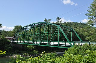
Bridge 15, also known locally as the River Bridge, spans the White River in Sharon, Vermont. Built in 1928, this multi-span Parker truss bridge is one of a shrinking number of White River crossings of this type. It was listed on the National Register of Historic Places in 2008.

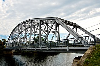
The Gould's Mill Bridge is a historic Baltimore through truss bridge, carrying Paddock Street across the Black River in Springfield, Vermont. The bridge was built by the Boston Bridge Works Company in 1929 after major flooding in 1927, and is one of the state's few examples of a Baltimore truss. It was listed on the National Register of Historic Places in 2006.

The Ottauquechee River Bridge is a steel girder bridge carrying United States Route 5 across the Ottauquechee River in Hartland, Vermont. The bridge replaced a c. 1930 Warren deck truss bridge, built in the wake of Vermont's devastating 1927 floods, and listed on the National Register of Historic Places in 1990.

The Quechee Gorge Bridge is a historic bridge, carrying U.S. Route 4 (US 4) across Quechee Gorge, near the Quechee village of Hartford, Vermont. Built in 1911, it is Vermont's oldest surviving steel arch bridge. It was listed on the National Register of Historic Places in 1990.

The Stockbridge Four Corners Bridge is a steel girder bridge carrying Vermont Route 100 across the White River near the village of Stockbridge Four Corners in Stockbridge, Vermont. The bridge is a 2009 replacement for 1929 Pratt through truss bridge, which was listed on the National Register of Historic Places in 1991. The historic bridge replaced an older covered bridge destroyed by Vermont's devastating 1927 floods.

The West Hartford Bridge is a steel deck girder bridge carrying Town Highway 14 across the White River in the village of West Hartford, Vermont. It was built by the town with state assistance in 2006, replacing a Parker through truss bridge built by the state after Vermont's devastating 1927 floods. The 1929 bridge was listed on the National Register of Historic Places in 1992.

The Burwell Bridge was a historic bridge on the northern edge of Burwell in Garfield County, Nebraska which was built in 1940–41. It was a steel girder bridge that brings Nebraska Highway 11 over the North Loup River. It is also known as the North Loup River Bridge and denoted as NEHBS Number GFOO-13. It was listed on the National Register of Historic Places in 1992, and was delisted in 2019.


