Related Research Articles

Port Phillip or Port Phillip Bay is a horsehead-shaped enclosed bay on the central coast of southern Victoria, Australia. The bay opens into the Bass Strait via a short, narrow channel known as The Rip, and is completely surrounded by localities of Victoria's two largest cities — metropolitan Greater Melbourne in the bay's main eastern portion north of the Mornington Peninsula, and the city of Greater Geelong in the much smaller western portion north of the Bellarine Peninsula. Geographically, the bay covers 1,930 km2 (750 sq mi) and the shore stretches roughly 264 km (164 mi), with the volume of water around 25 km3 (6.0 cu mi). Most of the bay is navigable, although it is extremely shallow for its size — the deepest portion is only 24 m (79 ft) and half the bay is shallower than 8 m (26 ft). Its waters and coast are home to seals, whales, dolphins, corals and many kinds of seabirds and migratory waders.

Dredging is the excavation of material from a water environment. Possible reasons for dredging include improving existing water features; reshaping land and water features to alter drainage, navigability, and commercial use; constructing dams, dikes, and other controls for streams and shorelines; and recovering valuable mineral deposits or marine life having commercial value. In all but a few situations the excavation is undertaken by a specialist floating plant, known as a dredger.

An artificial reef is a human-created underwater structure, typically built to promote marine life in areas with a generally featureless bottom, to control erosion, block ship passage, block the use of trawling nets, or improve surfing.

The Port River is part of a tidal estuary located north of the Adelaide city centre in the Australian state of South Australia. It has been used as a shipping channel since the beginning of European settlement of South Australia in 1836, when Colonel Light selected the site to use as a port. Before colonisation, the Port River region and the estuary area were known as Yerta Bulti by the Kaurna people, and used extensively as a source of food and plant materials to fashion artefacts used in daily life.

Ardrossan is a town in the Australian state of South Australia located on the eastern coast of the Yorke Peninsula, about 150 kilometres (93 mi) by road from the Adelaide city centre. It is notable for its deepwater shipping port and its towering coastal cliffs of red clay.

The Holdfast Bay is a small bay in Gulf St Vincent, next to Adelaide, South Australia. Along its shores lie the local government area of the City of Holdfast Bay and the suburbs of Glenelg and Glenelg North

The Backstairs Passage is a strait in South Australia lying between Fleurieu Peninsula on the Australian mainland and Dudley Peninsula on the eastern end of Kangaroo Island. The western edge of the passage is a line from Cape Jervis on Fleurieu Peninsula to Kangaroo Head on Kangaroo Island. The Pages, a group of islets, lie in the eastern entrance to the strait. About 14 km wide at its narrowest, it was formed by the rising sea around 13,000 years ago, at the end of the Pleistocene era, when it submerged the land connecting what is now Kangaroo Island with the Fleurieu Peninsula. Backstairs Passage was named by Matthew Flinders whilst he and his crew on HMS Investigator were exploring and mapping the coastline of South Australia in 1802.

Sinking ships for wreck diving sites is the practice of scuttling old ships to produce artificial reefs suitable for wreck diving, to benefit from commercial revenues from recreational diving of the shipwreck, or to produce a diver training site.
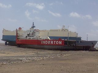
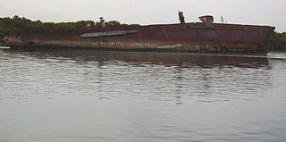
A ship graveyard or ship cemetery is a location where the hulls of scrapped ships are left to decay and disintegrate, or left in reserve. Such a practice is now less common due to waste regulations and so some dry docks where ships are broken are also known as ship graveyards.
The Santiago was a 455-ton barque launched in 1856. It was built by Henry Balfour of Methil, Fife for the Liverpool shipping company Balfour Williamson. It sailed mainly between Liverpool and Chile, but also to Australia. Its remnant hull, which lies in a ships' graveyard in South Australia, is considered 'the oldest intact iron hull sailing vessel in the world.'

The Gibraltar Artificial Reef, or simply the Gibraltar Reef, is the ongoing artificial reef project for the Mediterranean waters surrounding the British overseas territory of Gibraltar. The initiative was started in 1973 by Dr. Eric Shaw of the Helping Hand Trust.
The Society for Underwater Historical Research (SUHR) was an amateur maritime archaeology organisation operating in South Australia (SA). It was formed in 1974 by recreational scuba divers and other persons to pursue an interest in maritime archaeology and maritime history. The SUHR was renamed as the South Australian Archaeology Society in March 2012 as part of a plan to expand its activities beyond maritime archaeology to include other archaeological disciplines.
Zanoni was a ship built in Liverpool, England in 1865 by W. H. Potter & Co as a 338-ton composite barque. It was owned by Thomas Royden & Sons who intended to use it for the East India trade.

Garden Island is an island in the Australian state of South Australia located about 14 kilometres (8.7 mi) north-west of the capital city of Adelaide in an estuary system within the Adelaide metropolitan area which drains into Gulf St Vincent. It is notable as being a site for a mangrove forest, a landfill, a part of the site for the Multifunction Polis, a ship graveyard and a venue for recreational boating activities. It has enjoyed varying degrees of protected area status since 1973.
Aldinga Reef Aquatic Reserve is a marine protected area in the Australian state of South Australia located in waters adjoining the east coast of Gulf St Vincent including land within the intertidal zone in the suburbs of Aldinga Beach and Port Willunga about 40 kilometres (25 mi) south of the state capital of Adelaide.
The following index is provided as an overview of and topical guide to Wikipedia's articles on recreational dive sites. The level of coverage may vary:

Recreational dive sites are specific places that recreational scuba divers go to enjoy the underwater environment or for training purposes. They include technical diving sites beyond the range generally accepted for recreational diving. In this context all diving done for recreational purposes is included. Professional diving tends to be done where the job is, and with the exception of diver training and leading groups of recreational divers, does not generally occur at specific sites chosen for their easy access, pleasant conditions or interesting features.

Margaret Brock Reef is a reef in the Australian state of South Australia located in the state's coastal waters on its south-east coast about 7 kilometres (4.3 mi) west of the headland of Cape Jaffa and about 27.2 kilometres (16.9 mi) south-west of the town of Kingston SE. It is the site of both a navigation aid which operated as a staffed lighthouse from 1872 to 1973 and as an automatic beacon onward to the present day, and a rock lobster sanctuary declared under state law in 1973. It is named after the barque Margaret Brock which was wrecked there in 1852.
Yankalilla Bay is a long, wide bay in south-eastern South Australia, on the Fleurieu Peninsula. It is on the south-eastern coast of the Gulf St Vincent, as it opens into the Southern Ocean.
References
- 1 2 "Ardrossan Ships' Graveyard". Government of South Australia. Department for Environment and Water. Retrieved 22 November 2020.
- ↑ "Australian National Shipwreck Database (ANSD) - Unnamed barge". Commonwealth of Australia, Department of Environment. Retrieved 25 February 2015.
- ↑ "South Australian Shipwrecks, The Zanoni 1865 - 1867" (PDF). Heritage South Australia, Government of South Australia. 2000. Retrieved 27 February 2015.
- ↑ Boating Industry Association of South Australia (BIA); South Australia. Department for Environment and Heritage (2005), South Australia's waters an atlas & guide, Boating Industry Association of South Australia, p. 189, ISBN 978-1-86254-680-6
- ↑ "Artificial reefs". Primary Industries and Regions, South Australia. Retrieved 25 February 2015.
- ↑ "Bait up for an Easter bonanza". The Advertiser (Adelaide, SA). 13 April 1984. p. 16.