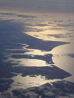
Hayling Island is an island off the south coast of England, in the borough of Havant in the county of Hampshire, east of Portsmouth. It is the third largest island in England by area, other than the Mainland, and the fifth largest by population.

The Portsmouth and Arundel Canal was a canal in the south of England that ran between Portsmouth and Arundel, it was built in 1823 but was never a financial success and was abandoned in 1855; the company was wound up in 1888. The canal was part of a larger scheme for the construction of a secure inland canal route from London to Portsmouth, which allowed craft to move between the two without having to venture into the English Channel and possibly encounter enemy ships or natural disaster. It was built by the Portsmouth & Arundel Navigation company. The canal was made up of three sections: a pair of ship canals, one on Portsea Island and one to Chichester, and a barge canal that ran from Ford on the River Arun to Hunston where it joined the Chichester section of the canal.

Havant is a town in the south east corner of Hampshire, England approximately midway between Portsmouth and Chichester. Its borough comprises the town and its suburbs including the resort of Hayling Island as well as Rowland's Castle, the smaller town of Waterlooville and Langstone Harbour. Housing and population more than doubled under either definition of Havant in the 20 years following World War II, a period of major conversion of land from agriculture and woodland to housing across the region following the incendiary bombing of Portsmouth and the Blitz.

Langstone is a village near Havant, Hampshire in the south east of England in Portsmouth. It has good railway connections to London, Southampton, Portsmouth and Brighton, from the nearby Havant railway station. There are many large gated detached houses on the main road, "Langstone Road" and on the roads surrounding this. It has a sailing club, several architecturally unusual buildings, and several historically significant buildings, including a converted (water) millhouse and a converted 18th century windmill, the latter of which is a local landmark.

The Phoenix breakwaters were a set of reinforced concrete caissons built as part of the artificial Mulberry harbours that were assembled as part of the follow-up to the Normandy landings during World War II. They were constructed by civil engineering contractors around the coast of Britain. They were collected at Dungeness and Selsey, and then towed by tugboats across the English Channel and sunk to form the Mulberry harbour breakwaters replacing the initial "Gooseberry" block ships. Further caisson were added in the autumn of 1944 to re-enforce the existing structure to cope with the harbour continuing in use longer than planned.

Chichester Harbour is a 3,733.5-hectare (9,226-acre) biological and geological Site of Special Scientific Interest (SSSI) west of Chichester in Hampshire and West Sussex. The SSSI is part of Chichester Harbour Area of Outstanding Natural Beauty and Solent Maritime Special Area of Conservation. It is also part of Chichester and Langstone Harbours Ramsar site, Special Protection Area and Nature Conservation Review site, Grade I. Part of it is a Geological Conservation Review site and two areas are Local Nature Reserves.

The Hayling Island branch was a railway in Hampshire, England, that connected Havant with Hayling Island. It was sometimes known as the Hayling Billy, a name now given to the footpath along the old track.
Baker's Island is an island in Langstone Harbour, Hampshire, England. It is 400 m (1,300 ft) long and up to 300 m (980 ft) wide but only rises to a little over 2 m (7 ft) above Ordnance Datum. Mesolithic and Neolithic flintwork has been found on the island along with Bronze Age and Romano-British pottery. There are a number of structures on the island including the remains of a flint walled building and five 5 by 1.5 m brick shelters believed to be part of a World War Two starfish decoy site. In 1978 the island along with the other islands in Langstone Harbour was acquired by the Royal Society for the Protection of Birds who turned it into a bird sanctuary. Since that time unauthorised landings have been forbidden.
South Binness Island is an island in Langstone Harbour. It is 600 metres (660 yd) long and up to 240 metres (260 yd) wide but only rises to 2 metres (7 ft) above Ordnance Datum. Archaeological finds include Bronze Age pottery and an unfinished Plano-convex knife.

Bedhampton is a former village, and now suburb, located in the Borough of Havant, Hampshire, England. It is located at the northern end of Langstone Harbour and at the foot of the eastern end of Portsdown Hill.

Langstone Bridge connects Hayling Island with the English mainland of Hampshire.

Langston was a small station on the Hayling Island branch. The station along with the rest of the line closed in 1963, and it served the Langstone area of Havant, a former village which had become contiguous with the larger town to its north. The railway companies always used the old spelling "Langston" for the station, in spite of this form not being used by the local community, and it can be seen in many photographs of the station sign.

The Hampshire Basin is a geological basin of Palaeogene age in southern England, underlying parts of Hampshire, the Isle of Wight, Dorset, and Sussex. Like the London Basin to the northeast, it is filled with sands and clays of Paleocene and younger ages and it is surrounded by a broken rim of chalk hills of Cretaceous age.

Portsbridge Creek is a tidal waterway that runs between Portsea Island and the mainland from Langstone Harbour to Tipner Lake. Through its history it has been made navigable a number of times and it is today navigable for small boats.

Long Island is an island in Langstone Harbour in Hampshire, England. It is 750 metres (820 yd) long and up to 250 metres (270 yd) wide. Three Bronze Age pots have been found on the island as has Mesolithic and late neolithic flint-work. Bronze Age pottery along with smaller amounts of Romano-British pottery have been found on the island.

Caesar's Camp is an Iron Age hill fort straddling the border of the counties of Surrey and Hampshire in southern England. The fort straddles the borough of Waverley in Surrey and the borough of Rushmoor and the district of Hart, both in Hampshire. Caesar's Camp is a Scheduled Ancient Monument with a list entry identification number of 1007895. It lies approximately 3 kilometres (1.9 mi) north of the town of Farnham, and a similar distance west of Aldershot. The hillfort lies entirely within the Bourley and Long Valley Site of Special Scientific Interest. Caesar's Camp is a multivallate hillfort, a fort with multiple defensive rings, occupying an irregular promontory, with an entrance on the south side. The site has been much disturbed by military activity, especially at the southeast corner. The remains of the hillfort are considered to be of national importance.
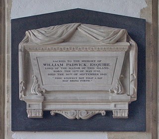
William Padwick, sometimes known as William Padwick the younger, was a significant figure in the development of Hayling Island in the mid-nineteenth century.

West Town is a village on Hayling Island in the borough of Havant in the county of Hampshire, England. It is on the south coast of the island, between Sinah to the west and Eastoke to the east. The wide area between the seafront road and the sea is known as Beachlands.