North Brisbane Burial Ground

Last updated

Looking across the former Paddington Cemetery, circa 1870 Queensland State Archives 517 Milton looking across the former Paddington Cemetery c 1870.png
Looking across the former Paddington Cemetery, circa 1870

The North Brisbane Burial Ground was a former cemetery in the Town of Brisbane, Queensland, Australia. It was in the area now known as the suburbs of Milton and Paddington. It was also known as North Brisbane Cemetery, Paddington Cemetery and Milton Cemetery.

Contents

Geography

The burial ground was located across four blocks bounded by Beatrice Street on the north, Hale Street on the east, Church Street on the south and the present-day Castlemain Street on the west. This land is now used as Lang Park stadium and Ithaca Swimming Pool and children's parkland. Maps showing the burial ground and its later reuse are published by the Brisbane City Council. [1]

History

Paddington Cemetery, 1917, now underneath Lang Park/Suncorp Stadium Paddington Cemetery Brisbane 1917.tiff
Paddington Cemetery, 1917, now underneath Lang Park/Suncorp Stadium

The First Brisbane Burial Ground was established in 1825 when Brisbane was established as the Moreton Bay penal colony at present-day Skew Street (near the William Jolly Bridge northern endpoint). It was in use until 1843 when the North Brisbane Burial Ground opened. [2]

The North Brisbane burial ground was in use from 1843 to 1875, during which time up to 10,000 people may have been buried there. [3] After 1875, the burial ground was closed and new burials were to take place in the newly established Toowong Cemetery.

Circa 1862 the Anglican Church established a mortuary chapel for the cemetery. It was demolished in 1891. [4]

The cemetery was flooded during the 1893 Brisbane flood. [5]

Memorial reserve, Christ Church, Milton, 2005 Memorial reserve, Christ Church, Milton, 2005.jpg
Memorial reserve, Christ Church, Milton, 2005

In 1907, the Ithaca Shire Council began to plan to convert the cemetery, by then a community eyesore, into a recreational reserve. However, the council did not control the land, as individual religious denominations continued to have control of their burial ground area. [6] By the 1910s, relatives were offered the opportunity to exhume and reinter deceased family members or to relocate their headstone or other monumental masonry. The first removals took place in 1913. [7] Over 500 headstones were removed into a memorial reserve, a small section of the Anglican section of the cemetery, adjacent to Christ Church. In 1914, it was developed as an athletics field called Lang Park and progressively redeveloped into Brisbane's major sporting stadium, Suncorp Stadium. [8]

During the Depression many of the headstones in the memorial reserve were removed or destroyed. [8] In 2001, the development of Hale Street into a major traffic route resulted in the resumption of some of the memorial reserve and the remaining headstones were reorganised into an even smaller memorial park behind Christ Church (and are only accessible via the churchyard). The further development of Suncorp Stadium visually encroaches on the memorial park, its high blue glass walls reflecting blue light into the memorial reserve. [8]

Operation

The North Brisbane burial ground was not a single cemetery, but rather a collection of cemeteries operated by different religious denominations.

Related Research Articles

<span class="mw-page-title-main">Milton, Queensland</span> Suburb of Brisbane, Queensland, Australia

Milton is a riverside inner suburb of the City of Brisbane, Queensland, Australia. In the 2016 census, the population of Milton was 2,274 people.

<span class="mw-page-title-main">Lang Park</span> Multi-purpose stadium in Brisbane, Australia

Lang Park, also known as Brisbane Football Stadium, by the sponsored name Suncorp Stadium, and nicknamed: 'The Cauldron', is a multi-purpose stadium in Brisbane, Queensland, Australia, located in the suburb of Milton. The current facility comprises a three-tiered rectangular sporting stadium with a capacity of 52,500 people. The traditional home of rugby league in Brisbane, the modern stadium is also now used for rugby union and soccer and has a rectangular playing field of 136 by 82 metres. The stadium's major tenants are the Brisbane Broncos, Queensland Maroons and Queensland Reds.

<span class="mw-page-title-main">Toowong</span> Suburb of Brisbane, Queensland, Australia

Toowong is a riverside suburb in the City of Brisbane, Queensland, Australia. In the 2016 census, Toowong had a population of 10,830 people.

<span class="mw-page-title-main">Tingalpa, Queensland</span> Suburb of Brisbane, Queensland, Australia

Tingalpa is a suburb in the City of Brisbane, Queensland, Australia. In the 2016 census, Tingalpa had a population of 8,290 people.

<span class="mw-page-title-main">Kedron, Queensland</span> Suburb of Brisbane, Queensland, Australia

Kedron is a northern suburb in the City of Brisbane, Queensland, Australia. In the 2016 census, Kedron had a population of 9,359 people.

<span class="mw-page-title-main">Wynnum, Queensland</span> Suburb of Brisbane, Queensland, Australia

Wynnum is a coastal suburb in the City of Brisbane, Queensland, Australia. In the 2016 census, Wynnum had a population of 12,915 people. The suburb is a popular destination in Brisbane due to its coastline, jetty and tidal wading pool.

<span class="mw-page-title-main">Brisbane central business district</span> Suburb of Brisbane, Queensland, Australia

Brisbane City is the central suburb and central business district of Brisbane, the state capital of Queensland, Australia. It is colloquially referred to as the "Brisbane CBD" or "the city". It is located on a point on the northern bank of the Brisbane River, historically known as Meanjin, Mianjin or Meeanjin in the local Aboriginal Australian dialect. The triangular shaped area is bounded by the median of the Brisbane River to the east, south and west. The point, known at its tip as Gardens Point, slopes upward to the north-west where the city is bounded by parkland and the inner city suburb of Spring Hill to the north. The CBD is bounded to the north-east by the suburb of Fortitude Valley. To the west the CBD is bounded by Petrie Terrace, which in 2010 was reinstated as a suburb.

<span class="mw-page-title-main">Yeronga, Queensland</span> Suburb of Brisbane, Queensland, Australia

Yeronga is a southern riverside suburb in the City of Brisbane, Queensland, Australia. In the 2016 census, Yeronga had a population of 6,535 people.

<span class="mw-page-title-main">Spring Hill, Queensland</span> Suburb of Brisbane, Queensland, Australia

Spring Hill is an inner northern suburb in the City of Brisbane, Queensland, Australia. In the 2016 census, Spring Hill had a population of 5,974 people.

<span class="mw-page-title-main">Paddington, Queensland</span> Suburb of Brisbane, Queensland, Australia

Paddington is an inner suburb in the City of Brisbane, Queensland, Australia. In the 2016 census, Paddington had a population of 8,562 people.

<span class="mw-page-title-main">Red Hill, Queensland</span> Suburb of Brisbane, Queensland, Australia

Red Hill is an inner northern suburb in the City of Brisbane, Queensland, Australia. In the 2016 census, Red Hill had a population of 5,560 people.

<span class="mw-page-title-main">Toowong Cemetery</span> Cemetery in Toowong, Brisbane

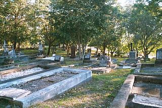
Toowong Cemetery is a heritage-listed cemetery on the corner of Frederick Street and Mt Coot-tha Road, Toowong, City of Brisbane, Queensland, Australia. It was established in 1866 and formally opened in 1875. It is Queensland's largest cemetery and is located on forty-four hectares of land at the corner of Frederick Street and Mount Coot-tha Road approximately four and a half kilometres west of Brisbane. It was previously known as Brisbane General Cemetery. It was added to the Queensland Heritage Register on 31 December 2002.

Ithaca is a former suburb of Brisbane, Australia. Since 1975, Ithaca has been designated a neighbourhood within the suburb of Red Hill in Brisbane.

<span class="mw-page-title-main">Edward Joseph Baines</span> Australian politician

Edward Joseph Baines was an alderman and mayor of the Brisbane Municipal Council.

<span class="mw-page-title-main">South Brisbane Cemetery</span> Historic site in Queensland, Australia

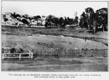
South Brisbane Cemetery is a heritage-listed cemetery at 21 Fairfield Road and Annerley Road, Dutton Park, City of Brisbane, Queensland, Australia, adjacent to the Brisbane River. It was built from 1870 to 1990s. It is also known as Dutton Park Cemetery. It was added to the Queensland Heritage Register on 1 October 2003.

<span class="mw-page-title-main">Christ Church, Milton</span> Historic site in Queensland, Australia

Christ Church is a heritage-listed Anglican church at 3 Chippendall Street, Milton, City of Brisbane, Queensland, Australia. The current church building is the second one at this site and was designed by John H Buckeridge and built in 1891 as a "temporary" structure but remains in use to this day. The rectory was built in 1883 to a design of F.D.G. Stanley. It is also known as the former Memorial Church. It was added to the Queensland Heritage Register on 21 October 1992.

<span class="mw-page-title-main">Drayton and Toowoomba Cemetery</span> Historic site in Queensland, Australia

Drayton and Toowoomba Cemetery is a heritage-listed cemetery at the corner of South Street and Anzac Avenue, Harristown, Queensland, Australia. It was surveyed in May 1850, and is one of the earliest surviving cemeteries in Queensland. The cemetery is large, containing over 45,000 burials. It has been run by the City of Toowoomba, and its successor the Toowoomba Regional Council, since 1974; previously it was run by government-appointed trustees. Many prominent people associated with the Darling Downs are buried in the cemetery, and all sections of the cemetery remain in use. Notable Toowoomba stonemasons R. C. Ziegler & Son, Henry Bailey, Walter Bruce, John H. Wagner and the Bruce Brothers are all associated with monuments within the cemetery.

<span class="mw-page-title-main">Christ Church, Tingalpa</span> Historic site in Queensland, Australia

Christ Church Tingalpa and Burial Ground is a heritage-listed former Anglican church at 1341 Wynnum Road, Tingalpa, City of Brisbane, Queensland, Australia. It was built from 1868 to 1993. It is now known as the Pioneer Wedding Chapel. It was added to the Queensland Heritage Register on 2 February 1998.

<span class="mw-page-title-main">South Rockhampton Cemetery</span> Historic site in Queensland, Australia

South Rockhampton Cemetery is a heritage-listed cemetery at Upper Dawson Road, Allenstown, Rockhampton Region, Queensland, Australia. It was built from 1860 to 1970. It is also known as Dawson Road Cemetery and Rockhampton Cemetery. It was added to the Queensland Heritage Register on 15 February 1993.

References

  1. "Showing the Old Paddington Cemeteries and the Present Reserves" (PDF). Brisbane City Council . Retrieved 10 March 2015.
  2. "First Brisbane Burial Ground (entry 700009)". Queensland Heritage Register . Queensland Heritage Council. Retrieved 1 August 2014.
  3. "Dr Jonathan Prangnell". University of Queensland . Retrieved 10 March 2015.
  4. "Closed Anglican Churches". Anglican Church South Queensland. Archived from the original on 3 April 2019. Retrieved 29 June 2020.
  5. "Flood map Suburbs of Brisbane sheets 1 and 1W left bank" (Map). Queensland Government. 1893.
  6. "Ithaca Town Council". The Brisbane Courier . National Library of Australia. 29 October 1907. p. 6. Retrieved 11 March 2015.
  7. "Paddington Cemetery". The Brisbane Courier . National Library of Australia. 7 June 1913. p. 4. Retrieved 11 March 2015.
  8. 1 2 3 "Christ Church (entry 600252)". Queensland Heritage Register . Queensland Heritage Council. Retrieved 1 August 2014.

Further reading

Commons-logo.svg Media related to Paddington cemetery, Queensland at Wikimedia Commons

Coordinates: 27°27′52″S153°00′36″E / 27.4645°S 153.0100°E / -27.4645; 153.0100