North Crimean Canal

Last updated
North Crimean Canal
Golovna sporuda Pivnichno-Krims'kogo kanalu.jpg
Water intake structure at the start of the canal at Tavriisk, 800 m from the Kakhovka reservoir
Nord-Krim-Kanal.png
Map of the canal
Specifications
Length402.6 km (250.2 miles)
History
Former namesNorth Crimean Canal of the Komsomol of Ukraine
Current owner
Original owner Soviet government
Principal engineerUkrvodbud
Other engineer(s)Ukrdiprovodbud
Date of actSeptember 21, 1950 (1950-09-21)
Construction began1957
Date completed1976
Geography
Start point Tavriisk, Ukraine
End point Kerch city water treatment facilities
Beginning coordinates 46°45′55″N33°23′40″E / 46.76528°N 33.39444°E / 46.76528; 33.39444
Ending coordinates 45°20′38″N36°00′36″E / 45.34389°N 36.01000°E / 45.34389; 36.01000
Branch(es)Krasnoznamiansky Canal
Soyedenitelny Canal
Connects to Dnieper River

The North Crimean Canal, [lower-alpha 1] formerly known as the North Crimean Canal of the Lenin's Komsomol of Ukraine [lower-alpha 2] in Soviet times, is a land improvement canal for irrigation and watering of Kherson Oblast in southern Ukraine and the Crimean Peninsula. The canal has multiple branches throughout Kherson Oblast and Crimea, and is normally active from March until December. [1]

Contents

Preparation for construction began in 1957, soon after the transfer of Crimea to the Ukrainian Soviet Socialist Republic in 1954. The main project works took place in three stages between 1961 and 1971. The construction was conducted by the Komsomol members sent by the Komsomol travel ticket (Komsomolskaya putyovka) as part of shock construction projects and accounted for some 10,000 volunteer workers.

A dry part of the canal near Lenine, Kerch Peninsula, in July 2014 Pohja- Krimmi kanal.jpg
A dry part of the canal near Lenine, Kerch Peninsula, in July 2014

Ukraine shut down the canal in 2014 soon after Russia annexed Crimea. Russia restored the flow of water in March 2022 during the Russian invasion of Ukraine.

A 2015 study found that the canal had been providing 85% of Crimea's water prior to the 2014 shutdown. Of the water from the canal, 72% went to agriculture and 10% to industry, while water for drinking and other public uses made up 18%. [2]

Overview

The canal begins at the city of Tavriisk, where it draws from the Kakhovka Reservoir fed by the Dnieper river, and runs for 402.6 km (250.2 mi) in a generally southeasterly direction, terminating at the small village of Zelnyi Yar (Lenine Raion). From there, a pipeline carries water to supply the city of Kerch at the eastern extreme of the Crimean Peninsula. [3] Seven water reservoirs lie along the main canal – they are Mizhhirne, Feodosiiske, Frontove, Leninske, Samarlynske, Starokrymske and Stantsiine (Kerchenske).

Water flows by gravity from Tavriisk to Dzhankoi, where it is elevated by four pump stations to a height of over 100 m (330 ft) to energize its continued downstream flow. In Crimea, numerous smaller canals branch off the main channel, including the Razdolne rice canal, Azov rice canal, Krasnohvardiiske distribution canal, Uniting canal, and Saky canal. Through these, water is also supplied to the city of Simferopol. [3]

Postage stamp of the USSR Post, 1951 USSR stamp 1951 CPA 1653.jpg
Postage stamp of the USSR Post, 1951

The idea to construct the canal was raised in the 19th century, particularly by the Russian-Finnish botanist Christian von Steven. It was not until after World War II when the decision was adopted in September 1950 by the Central Committee of the Communist Party of the Soviet Union and the Government of the Soviet Union. The decision was to build the Kakhovka Hydro Electric Station, South Ukrainian and North Crimean canals. In 1951 the Soviet postal service released a commemorative post stamp where the North Crimean Canal was categorized as one of the Great Construction Projects of Communism.

Construction of the canal and irrigation systems began in 1957 and was carried out in several stages. The first stage opened in October 1963, carrying water as far as Krasnoperekopsk in the north. In 1965 the canal was completed as far as the city of Dzhankoi in the center of Crimea. In 1971 the city of Kerch was reached. In December 1976 the canal was officially put into operation. [4] [5]

2014–2023

After the Maidan revolution and the subsequent Russian annexation of Crimea in March 2014, Ukrainian authorities greatly reduced the volume of water flowing to the peninsula by means of damming the canal south of Kalanchak, about 10 miles (16 km) north of the Crimean border. [6] This began a severe water crisis in Crimea  [ uk ]. [7] The reduction caused the peninsula's agricultural harvest, which is heavily dependent on irrigation, to fail in 2014. [6]

Crimean water sources were connected to the North Crimean Canal to replace the former Ukrainian sources. The objective was to restore irrigation and urban supplies to the Kerch Peninsula and to smaller communities on the east coast of Crimea. [8] In 2014, a reservoir was built to store water of the rivers of Eastern Crimea near the village of Novoivanovka, Nyzhnohirskyi Raion. The North Crimean Canal is connected with the Novoivanovka reservoir. [9]

According to official Russian statistics, the Crimean agricultural industry fully overcame the consequences of the blocking of the North Crimean Canal and crop yields grew by a factor of 1.5 from 2013 by 2016. [10] The reported rapid growth in agricultural production in Crimea is due to the fact that, with the help of subsidies in the order of 2–3 billion rubles a year from the budget of the Russian Federation, agricultural producers in Crimea were able to increase their fleet of agricultural machinery. [11] [12] [13]

These official statistics contrast with reports of a massive shrinkage in the area under cultivation in Crimea, from 130,000 hectares in 2013 to just 14,000 in 2017, [14] and an empty canal and a nearly dry reservoir resulting in widespread water shortages, [15] [16] [7] with water only being available for three to five hours a day in 2021. [16] That same year, the New York Times cited senior American officials as stating that securing Crimea's water supply could be an objective of a possible incursion by Russia into Ukraine. [17] [7]

On 24 February 2022, the first day of the Russian invasion of Ukraine, Russian troops advancing from Crimea established control over the North Crimean Canal. [18] The Head of the Republic of Crimea, Sergey Aksyonov, told local authorities to prepare the canal to receive water. [19] [20] Two days later, Russian forces used explosives to destroy the dam that had been blocking the flow since 2014, and water supply resumed. [21] [2]

On the morning of 6 June 2023, a significant portion of the Kakhovka Dam was destroyed releasing a large amount of water downstream. The Kakhovka Reservoir is the source of water for the canal. [22] [23]

According to Christopher Binnie, a water engineer specializing in dams and water resources development, "Pumping for water supply to the Crimea could restart fairly soon." [24] Sergey Aksyonov said that by installing pumps on the Dnieper River, up to 40 m³/sec could be supplied to the canal, and that this would improve the situation. [25]

Rate of flow

The normal flow rate of water in the North Crimean Canal seems to be subject to some disagreement, but according to the Ukrainian State Agency for Water Resources the normal water flow rate in the head of the canal is 82 m³/sec. [26] Concurring roughly with this is Agribusiness Global (90 m³/sec), [27] so the proposed rate by pumping would result in half the normal rate. Water flows through the North Crimean Canal by gravity until it reaches the Dzhankoi district, where it meets the first of a series of pumping stations that must pump it uphill. The first pumping station has a capacity of about 70 m³/sec. [28] According to First Deputy Prime Minister of Russian-annexed Crimea, Rustam Temirgaliyev in 2014, the normal flow of water through the North Crimean Canal was 50 m³/sec. [29] A number of other sources also report this figure. [30] [31] [32] [33] [34] Euromaidan Press reports 294 m³/sec [1] as does another source. [35] On the high end is a source reporting 380 m³/sec, with 80 m³/sec of this going to Kherson and the remainder going to Crimea. [36]

According to a 2023 study, in the early 1990s annual water flows into the canal from the reservoir reached 3.5 km³, but a more economical use of water reduced this to 1.5 km³, of which 0.5 km³ were used in the Kherson region and 1.0 km³ in Crimea. In 2014, after the annexation of Crimea, this was reduced to 0.5 km³, according to the study. [37] 1.5 km³ is the amount of water that would result from a flow of 47.5 m³/sec for one year. According to a 2017 study in a Russian journal, in 2013, the total water intake of Crimea amounted to 1,553.78 million m³, of which 86.65% came from the North Crimean Canal, 8.78% from local runoff, 4.41% from underground water, and 0.16% from seawater. [38] This means that 1,346.35 million m³ came from the canal, which translates to a flow rate of 42.7 m³/sec during 2013, according to this source. If 1/3 of the water entering the North Crimean Canal was distributed in Kherson, as indicated by the 2023 study, and 1,346.35 million m³ arrived in Crimea, then this indicates a water flow into the canal during 2013 of 64 m³/sec.

The average flow in the Dnieper River is about 1,670 m³/sec. [39] The amount of water flowing past the intake point of the North Crimean Canal is regulated by the five reservoirs upstream on the Dnieper River, all controlled by Ukraine. Two major canals take in water upstream from the North Crimean Canal, from what was originally the Kakhovka Reservoir: the Kakhovsky Canal and the Dnieper-Kryvyi Rih canal. [40] Also taking water from the former Kakhovka Reservoir were various minor irrigation systems, freshwater fish farms, and systems supplying water to cities such as Zaporizhzhia. The total withdrawal of water from the Kakhovka Reservoir just for large canals was estimated at 900 m³/sec. [41]

See also

Kakhovskaia GES.jpg
A panorama of the Kakhovka Reservoir and the hydroelectric power station from which the canal begins. In the Summer of 2023, the power station and dam were completely destroyed and the reservoir drained. Without the reservoir the canal could not be supplied with water and became dry.

Notes

    • Ukrainian: Північнокримський канал, romanized: Pivnichnokrymskyi kanal
    • Russian: Северо-Крымский канал, romanized: Severo-Krymskii Kanal
    • Ukrainian: Північно-Кримський канал імені ЛКСМУ, romanized: Pivnichno-Krymskyi kanal imeni LKSMU
    • Russian: Северо-Крымский канал имени Ленинского комсомола Украины, romanized: Severo-Krymsky kanal imeni Leninskogo komsomola Ukrainy

Related Research Articles

<span class="mw-page-title-main">Crimea</span> Peninsula in Europe

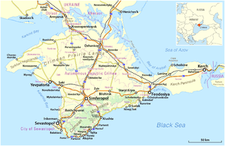
Crimea is a peninsula in Eastern Europe, on the northern coast of the Black Sea, almost entirely surrounded by the Black Sea and the smaller Sea of Azov. The Isthmus of Perekop connects the peninsula to Kherson Oblast in mainland Ukraine. To the east, the Crimean Bridge, constructed in 2018, spans the Strait of Kerch, linking the peninsula with Krasnodar Krai in Russia. The Arabat Spit, located to the northeast, is a narrow strip of land that separates the Syvash lagoons from the Sea of Azov. Across the Black Sea to the west lies Romania and to the south is Turkey. The largest city is Sevastopol. The region has a population of 2.4 million, and has been under Russian occupation since 2014.

<span class="mw-page-title-main">Dnieper</span> River in Eastern Europe

The Dnieper, also called Dnipro or Dniapro, is one of the major transboundary rivers of Europe, rising in the Valdai Hills near Smolensk, Russia, before flowing through Belarus and Ukraine to the Black Sea. Approximately 2,200 km (1,400 mi) long, with a drainage basin of 504,000 square kilometres (195,000 sq mi), it is the longest river of Ukraine and Belarus and the fourth-longest river in Europe, after the Volga, Danube, and Ural rivers.

<span class="mw-page-title-main">Nova Kakhovka</span> City in Kherson Oblast, Ukraine

Nova Kakhovka is a city in Kakhovka Raion, Kherson Oblast, southern Ukraine. Nova Kakhovka has been under Russian occupation since February 2022. Its estimated population in 2022 was 44,427.

<span class="mw-page-title-main">Isthmus of Perekop</span> Isthmus

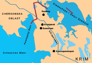
The Isthmus of Perekop, literally Isthmus of the Trench, is the narrow, 5–7 kilometres (3.1–4.3 mi) wide strip of land that connects the Crimean Peninsula to the mainland of Ukraine. The isthmus projects between the Black Sea to the west and the Syvash to the east. The isthmus takes its name of "Perekop" from the Tatar fortress of Or Qapi.

<span class="mw-page-title-main">Kherson Oblast</span> Oblast (region) of Ukraine

Kherson Oblast, also known as Khersonshchyna, is an oblast (province) in southern Ukraine. It is located just north of Crimea. Its administrative center is Kherson, on the northern or right bank of the Dnieper river, which bisects the oblast. The oblast has an area of 28,461 km2 and a population of 1,001,598. It is considered the 'fruit basket' of the country, as much of its agricultural production is dispersed throughout the country, with production peaking during the summer months.

<span class="mw-page-title-main">Konka (river, Zaporizhzhia Oblast)</span> River in Ukraine

The Konka, also known as the Kinka, Kinska, or Kinski Vody is a left tributary of the Dnieper, flowing through Zaporizhzhia Oblast, Ukraine. It is 146 km (91 mi) long, and has a drainage basin of 2,580 km2 (1,000 sq mi). It originates in the Azov Upland and flows into the Kakhovka Reservoir on the Dnieper. The cities of Polohy and Orikhiv are located on the river.

<span class="mw-page-title-main">Kakhovka Reservoir</span> Hydroelectric reservoir in Kherson, Zaporizhzhia and Dnipropetrovsk oblasts

The Kakhovka Reservoir was a water reservoir on the Dnieper River in Ukraine. It was created in 1956 by construction of the Kakhovka Dam at Nova Kakhovka. It was one of several reservoirs in the Dnieper reservoir cascade.

<span class="mw-page-title-main">Dnieper reservoir cascade</span> Flood control system in Ukraine

The Dnieper reservoir cascade or Dnieper cascade of hydroelectric power stations is a series of dams, reservoirs and hydroelectric power stations on the Dnieper river in Ukraine. It was created to prevent uncontrolled flooding and improve water transportation infrastructure. Coordination and operation of all dams on the Dnieper is conducted by government company Ukrhydroenergo. In 1970, the Kyiv dam partially prevented flooding in comparison with the 1931 Kyiv flooding.

<span class="mw-page-title-main">Kakhovka</span> Town in Kherson Oblast, Ukraine

Kakhovka is a port city on the Dnieper River in Kakhovka Raion, Kherson Oblast, of southern Ukraine. It hosts the administration of the Kakhovka urban hromada, one of the hromadas of Ukraine. It had a population of 34,749.

<span class="mw-page-title-main">Inhulets</span> River in Ukraine

The Inhulets or Ingulets is a river, a right tributary of the Dnieper, that flows through Ukraine. It has a length of 557 kilometres (346 mi) and a drainage basin of 14,460 square kilometres (5,580 sq mi).

<span class="mw-page-title-main">Oleshky</span> City in Kherson Oblast, Ukraine

Oleshky, previously known as Tsiurupynsk from 1928 to 2016, is a city in Kherson Raion, Kherson Oblast, southern Ukraine, located on the left bank of the Dnieper River with the town of Solontsi to the south. It is the oldest city of the oblast and one of the oldest in southern Ukraine. It is known for its proximity to the Oleshky Sands, a large desert region. Oleshky is the site of artist Polina Rayko's home, a national cultural monument of Ukraine. It also hosts the administration of Oleshky urban hromada, one of the hromadas of Ukraine. It had a population of 24,124.

Tavriisk is a small city in Kakhovka Raion, Kherson Oblast, southern Ukraine, close to the city of Nova Kakhovka. It is located on the left bank of the Dnieper River. Tavriisk hosts the administration of the Tavriisk urban hromada, one of the hromadas of Ukraine. It has a population of 10,108.

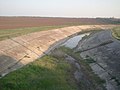
Canals in Ukraine are mostly for irrigation or water supply. Most of them are supervised by the Canal Administration of the State Agency of water resources of Ukraine. As the rest of water resources canals compose the Water Fund of Ukraine and are included in the Water Cadastre (register) of Ukraine.

<span class="mw-page-title-main">Kakhovka Dam</span> Dam and power plant in Kherson, Ukraine

The Kakhovka Dam was a dam on the Dnieper River in Kherson Oblast, Ukraine, completed in 1956 and destroyed in 2023, which provided water for the Kakhovka Hydroelectric Station. The primary purposes of the dam were hydroelectric power generation, irrigation, and navigation. It was the sixth and last dam in the Dnieper reservoir cascade.

<span class="mw-page-title-main">Republic of Crimea</span> First-level administrative division of Russia, annexed territory of Ukraine

The Republic of Crimea is a republic of Russia, comprising most of the Crimean Peninsula, but excluding Sevastopol. Its territory corresponds to the Autonomous Republic of Crimea, a subdivision of Ukraine. Russia occupied and annexed the peninsula in 2014, although the annexation remains internationally unrecognized.

<span class="mw-page-title-main">Crimean Titan</span> Chemical manufacturer in Armyansk, Crimea

Crimea TITAN is the largest manufacturer of titanium dioxide pigment in Eastern Europe. It is located in Armyansk, Crimea.

The Rohachyk river is a left tributary of the Dnieper river in Kherson oblast, Ukraine. It has a length of 41 km. The river valley is up to 200 m wide. The width is generally 5 m. There are several ponds on the river. It names derives from a Ukrainian word for the "horn" as the river is winding.

<span class="mw-page-title-main">Southern Ukraine campaign</span> Theater of conflict in the Russian invasion of Ukraine

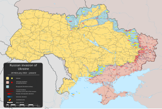
The southern Ukraine campaign is an ongoing theatre of operation in the Russian invasion of Ukraine, which began on 24 February 2022. From their base in Russian-occupied Crimea, the Russian Armed Forces attacked Kherson Oblast, Mykolaiv Oblast, and Zaporizhzhia Oblast in southern Ukraine, battling the Armed Forces of Ukraine.

<span class="mw-page-title-main">Nova Kakhovka River Port</span> Port in Ukraine

Nova Kakhovka River Port is in Tavriisk, a town on the eastern side of Nova Kakhovka, in Kherson Oblast, Ukraine. The port is on the left bank of the Dnipro river, at the south-western end of the Kakhovka Reservoir, adjacent to Kakhovka Dam. The port is in a basin at the upstream end of the shipping lock that passes through the dam. The port opened in 1962.

<span class="mw-page-title-main">Destruction of the Kakhovka Dam</span> 2023 dam breach in Ukraine

The Kakhovka Dam in Ukraine was breached in the early hours of 6 June 2023, causing extensive flooding along the lower Dnieper river, also called the Dnipro, in Kherson Oblast. The dam was under the control of the Russian military, which had seized it in the early days of the Russian invasion of Ukraine. Many experts have concluded that Russian forces likely blew up a segment of the dam to hinder the planned Ukrainian counter-offensive. Russian authorities have denied the accusation.

References

  1. 1 2 "North Crimea Canal, A History of its Construction". Euromaidan Press. 2014-05-24. Retrieved 2023-06-23.
  2. 1 2 "North Crimean Canal Fills With Water After Russian Forces Destroyed Dam". The Moscow Times . 4 March 2022. Archived from the original on 18 May 2022. Retrieved 18 May 2022.
  3. 1 2 Tymchenko, Zinaida (13 May 2014). "Північно-Кримський канал. Історія будівництва" [North Crimean Canal. History of construction (reprint from the "Krymskie Izvestia" published in 2012]. Ukrayinska Pravda Історична правда (in Ukrainian). Archived from the original on 21 March 2022. Retrieved 2 March 2022.
  4. "Berezovsky, E. Северо-Крымский – дорога куда?" [North-Crimean is road to where?]. Ekologiya i Mir (Crimean Republican Association). Archived from the original on 2013-04-02. Retrieved 2013-06-24.
  5. "Bericht in Neues Deutschland vom 1. Januar 1976" [Report in Neues Deutschland of January 1, 1976]. Archived from the original on 28 September 2013. Retrieved 22 September 2013.
  6. 1 2 "Russia fears Crimea water shortage as supply drops". BBC News . 25 April 2014. Archived from the original on 8 March 2021. Retrieved 26 April 2014.
  7. 1 2 3 Troianovski, Anton (8 May 2021). "Where Ukrainians Are Preparing for All-Out War With Russia". The New York Times . Archived from the original on 24 May 2021. Retrieved 21 May 2021.
  8. "New Pipelines Start Supplying Fresh Water to Crimea". en.voicesevas.ru. Archived from the original on 2020-01-26. Retrieved 2015-05-25.
  9. "Крым покончил с водным шантажом Украины" [Crimea ended the water blackmail of Ukraine]. Svobodnaya Pressa (in Russian). 22 April 2015. Archived from the original on 21 March 2022. Retrieved 2 March 2022.
  10. "Продукция сельского хозяйства Республики Крым" [Agricultural products of the Republic of Crimea statistics с/х](PDF) (in Russian). Archived from the original (PDF) on 7 November 2017. Retrieved 22 March 2019.
  11. "с/х машины Крыма" [Agricultural machines of Crimea](PDF). Archived from the original (PDF) on 7 November 2017. Retrieved 22 March 2019.
  12. "Государственная поддержка сельского хозяйства - Правительство Республики Крым" [State support of agriculture - the Government of the Republic of Crimea]. msh.rk.gov.ru. Archived from the original on 7 November 2017. Retrieved 3 November 2017.
  13. "В Минсельхоз Крыма поступило 1200 заявок на получение субсидий на сумму более 1,5 миллиарда рублей — Министерство сельского хозяйства Республики Крым - Правительство Республики Крым" [The Ministry of Agriculture of the Crimea received 1,200 applications for subsidies worth more than 1.5 billion rubles - Ministry of Agriculture of the Republic of Crimea - Government of the Republic of Crimea]. msh.rk.gov.ru. Archived from the original on 7 November 2017. Retrieved 3 November 2017.
  14. Clara Ferreira Marques (19 March 2021). "Crimea's Water Crisis Is an Impossible Problem for Putin". www.bloomberg.com. Bloomberg. Archived from the original on 13 May 2021. Retrieved 24 March 2021.
  15. Mirovalev, Mansur (4 January 2017). "Dam leaves Crimea population in chronic water shortage". Al Jazeera . Archived from the original on 1 March 2022. Retrieved 21 May 2021.
  16. 1 2 Mirovalev, Mansur (21 May 2021). "The devastating human, economic costs of Crimea's annexation". Al Jazeera . Archived from the original on 25 May 2021. Retrieved 21 May 2021.
  17. Cooper, Helene; Barnes, Julian E. (5 May 2021). "80,000 Russian Troops Remain at Ukraine Border as U.S. and NATO Hold Exercises". New York Times . Archived from the original on 14 January 2022. Retrieved 19 January 2022.
  18. "Российские войска берут под контроль Херсонщину: Крым готов получать воду" [Russian troops take control of Kherson region: Crimea is ready to receive water]. eadaily.com. 24 February 2022. Archived from the original on 24 February 2022. Retrieved 24 February 2022.
  19. "Российские войска вышли к Херсону и восстановили подачу воды в Крым" [Russian troops went to Kherson and restored water supply to the Crimea] (in Russian). RIA Novosti. 24 February 2022. Archived from the original on 24 February 2022. Retrieved 24 February 2022.
  20. "Canal in annexed Crimea to be readied for water from Ukraine's Dnieper, official says". National Post . Reuters. 24 February 2022. Archived from the original on 1 March 2022. Retrieved 24 February 2022.
  21. "В Крым пошла вода — украинской дамбы больше нет" [Water went to the Crimea - the Ukrainian dam is no more]. eadaily.com. 26 February 2022. Archived from the original on 21 March 2022. Retrieved 26 February 2022.
  22. Ogirenko, Valentyn; Kelly, Lidia (6 June 2023). "Nova Kakhovka dam in Kherson region blown up by Russian forces - Ukraine's military". Reuters. Archived from the original on 6 June 2023. Retrieved 6 June 2023.
  23. Sullivan, Helen (6 June 2023). "Russia-Ukraine war live: dam near Kherson destroyed by Russian forces, says Ukraine, sparking evacuations". the Guardian. Archived from the original on 6 June 2023. Retrieved 6 June 2023.
  24. "Expert reaction to reported attack on Ukraine's Kakhovka dam". Science Media Centre. Archived from the original on 2023-06-10. Retrieved 2023-06-10.
  25. "A well that runs dry. The Kakhovka dam break has dealt a major blow to Crimean authorities: the region's harvest is under threat". Novaya Gazeta Europe. 2023-06-12. Retrieved 2023-06-22.
  26. "Crimea increases unauthorized water withdrawal from North Crimean Canal". Ukrinform. 2014-04-29. Retrieved 2023-06-23.
  27. Nelson, Jessica (2014-04-30). "Crimean Agriculture Uncertain Amid Service Disruptions". AgriBusiness Global. Retrieved 2023-06-23.
  28. "Wall posts". VK. Retrieved 2023-06-24.
  29. "Ukraine reduces water supplies to Crimea". Interfax-Ukraine. 2014-04-14. Retrieved 2023-06-23.
  30. "Ukraine cuts off water supplies to Crimea". Ақ Жайық. 2014-04-16. Retrieved 2023-06-23.
  31. "Ukraine reduces water supplies to Crimea by three times -- Crimea's first vice-premier". Equipo Nizkor. Retrieved 2023-06-23.
  32. "Russian invaders already steal Ukraine's water worth UAH 620 mln – inspectorate". Interfax-Ukraine. 2022-03-17. Retrieved 2023-06-23.
  33. "Crimea faces motor fuel shortages". Times of Malta. 2014-04-26. Retrieved 2023-06-23.
  34. "Occupiers stealing en masse Dnipro water to Crimea. Debt may amount to billions of hryvnias". hromadske. 2022-07-02. Retrieved 2023-06-23.
  35. Orgland, Olav Bing (2021-04-07). "Water Wars: Drought by the Dnipro, the new conflict between Russia and Ukraine". SDAFA. Retrieved 2023-06-23.
  36. "Crimean Collaborators, Dry Canal and Fake Pumps". Association of Reintegration of Crimea. 2023-06-11. Retrieved 2023-06-23.
  37. Vyshnevskyi, Viktor; Shevchuk, Serhii; Komorin, Viktor; Oleynik, Yurii; Gleick, Peter (2023-07-04). "The destruction of the Kakhovka dam and its consequences". Water International. 48 (5). Informa UK Limited: 631–647. doi:10.1080/02508060.2023.2247679. ISSN   0250-8060.
  38. Vasilenko, V. A. (2017). "Hydro-economic problems of Crimea and their solutions". Regional Research of Russia. 7 (1). Pleiades Publishing Ltd: 89–96. doi:10.1134/s2079970516040146. ISSN   2079-9705.
  39. "Dnieper River". Encyclopedia Britannica. 1998-07-20. Retrieved 2023-06-23.
  40. Kirk, Ashley (2023-06-08). "Maps show how Kakhovka dam collapse threatens Ukraine's bread basket". the Guardian. Retrieved 2023-06-23.
  41. Яцик, А. В.; Яцик, В. А. (2012). Каховське водосховище (in Ukrainian). Vol. 12. Інститут енциклопедичних досліджень НАН України. ISBN   9789660220744 . Retrieved 2023-06-24.

46°45′52″N33°23′41″E / 46.76444°N 33.39472°E / 46.76444; 33.39472