North Dumfries

Last updated

North Dumfries
Township of North Dumfries
Downtown Ayr, Ontario.jpg
Downtown Ayr
Waterloo locator map 2021.svg
Red pog.svg
North Dumfries
Canada Southern Ontario location map 2.png
Red pog.svg
North Dumfries
Coordinates: 43°19′N80°23′W / 43.32°N 80.38°W / 43.32; -80.38
CountryFlag of Canada (Pantone).svg  Canada
ProvinceFlag of Ontario.svg  Ontario
Region Waterloo
Settled1816
Incorporated1819
Government
  MayorSusan Foxton
  Federal riding Cambridge
  Prov. riding Cambridge
Area
[1]
  Land187.44 km2 (72.37 sq mi)
Population
 (2016) [2]
  Total10,215
  Density54.5/km2 (141/sq mi)
Time zone UTC-5 (EST)
  Summer (DST) UTC-4 (EDT)
Postal Code
N0B
Area code(s) 519, 226, 548
Website www.northdumfries.ca OOjs UI icon edit-ltr-progressive.svg

The Township of North Dumfries is a rural township in Ontario, Canada, part of the Regional Municipality of Waterloo.

Contents

Communities

North Dumfries includes the following communities: Ayr, Branchton, Clyde (formerly from Beverley Township, Wentworth County), Reidsville and Roseville. It also contains rural clusters and hamlets such as Brown, Clarkson, Dickie One, Dickie Two, Dumfries, Greenfield, Hall, H’Ayritage, Highway Twenty-Four, Innanen, Lockie, Mackie, McLean, Morrison, Orr's Lake, Parker, Plumtree, Ranchlands, Riverview, Taylor, Wrigley and Young. [3] [4] [5] [6] [7] [8]

History

The history of North Dumfries is closely tied to that of the old City of Galt, now part of the City of Cambridge but which in the early 19th century was part of Gore District. Galt was founded on the east bank of the Grand River by Absalom Shade on behalf of William Dickson of Niagara. Dickson had bought 94,305 acres (381.64 km2) of land in 1816 for 24,000 pounds, and named it after his hometown of Dumfries in Scotland. The Nith River passes through Dumfries in Canada just as the River Nith passes through Dumfries in Scotland. That same year, he had the land surveyed and opened it for settlement. By 1817, a number of sawmills were operating in the district and the population, comprising 38 families, had reached 163. In 1819, the first municipal meeting for the Township of Dumfries North was held. [9]

In 1820, Dickson encouraged further settlement on his land by inviting other Scotsmen to buy land, resulting in a wave of immigration from 1825 until 1832 when every plot of land was filled. [9]

What is now the village of Ayr, then consisting of three small settlements, was first settled in 1822 by Abel Mudge, initially as a squatter. He built a dam, a sawmill and a grist mill at the junction of Smith and Cedar Creek. A post office opened at the settlement called Mudge's Mills in 1840, with the name Ayr, named after a town in Scotland. The other two settlements, Jedburgh to the east and Nithvale to the west, were not yet a part of Ayr but received their mail at the single post office. The population in 1846 was 230 persons, working in businesses such as a grist mill, barrel making, carpentry, wool processing, blacksmithing, tanning hides, making shoes and clothing, or carpentry. The population of Ayr did not reach 1000 until almost 1870. The largest business was a foundry.

In 1847 or 1848, the John Watson Manufacturing Company (later Ayr Machinery Works) had opened and became very successful, shipping iron implements across the country by 1870. By 1854, the village had a small library, two school houses, a fire company, a newspaper and a single (Presbyterian) church.

In 1858, Cruickston Park house was rebuilt by New York architect Detlef Lienau for the American heiress Eliza Astor and her English husband Matthew Wilks, and was later home tot their son Matthew Astor Wilks. [10] The house has been used as a filming location for TV series and for the 2010 film Red .

The village of Ayr, including Jedburgh, was incorporated in 1884 with John Watson as the Reeve. [11] What is now North Dumfries originally formed the north half of Dumfries Township, hence the current name. With the introduction of the county system in the mid-nineteenth century, Dumfries was split between the new Waterloo and Brant Counties. The remaining southern half of the old Dumfries Township is now South Dumfries in Brant County. At about the same time Dumfries Township was divided, the City of Galt was extracted from it as an autonomous municipality within the new Waterloo County. Though the two municipalities (Galt and North Dumfries) were now technically separated from one another, their histories are tightly interwoven as the township nearly envelopes what was then Galt.

The township's easternmost section (around the village of Clyde) was originally part of Beverley Township (now the city of Hamilton); it was transferred to North Dumfries Township in 1973.

Demographics

In the 2021 Census of Population conducted by Statistics Canada, North Dumfries had a population of 10,619 living in 3,689 of its 3,768 total private dwellings, a change of

The ethnic makeup of the township is 97.5% White, 1% Aboriginal and 1.5% visible minorities, of which the largest groups are Black (0.4%), South Asian and Latin American (0.3% each). Around 21.2% of the population is under the age of 14, while those over 65 number 10.3%. The average age is 39.0. There are 3050 private dwellings occupied by usual residents, out of a total of 3103 dwellings. Mother tongues spoken are: [13]

Population trend: [14]

Local government

The citizens of North Dumfries are represented by the mayor and four township councillors. The mayor is directly elected while the councillors are elected in four wards. The mayor serves as the township's sole representative on Regional Council. As of the 2018 election, the elected council members are: [15]

Mayor: Sue Foxton

Councillors:

See also

Related Research Articles

<span class="mw-page-title-main">Waterloo, Ontario</span> City in Ontario, Canada

Waterloo is a city in the Canadian province of Ontario. It is one of three cities in the Regional Municipality of Waterloo. Waterloo is situated about 94 km (58 mi) west-southwest of Toronto. Due to the close proximity of the city of Kitchener to Waterloo, the two together are often referred to as "Kitchener–Waterloo", "K-W", or "The Twin Cities".

<span class="mw-page-title-main">Cambridge, Ontario</span> City in Ontario, Canada

Cambridge is a city in the Regional Municipality of Waterloo, Ontario, Canada, located at the confluence of the Grand and Speed rivers. The city had a population of 138,479 as of the 2021 census. Along with Kitchener and Waterloo, Cambridge is one of the three core cities of Canada's tenth-largest metropolitan area.

<span class="mw-page-title-main">Regional Municipality of Waterloo</span> Upper-tier regional municipality in Ontario, Canada

The Regional Municipality of Waterloo is a metropolitan area of Southern Ontario, Canada. It contains the cities of Cambridge, Kitchener and Waterloo, and the townships of North Dumfries, Wellesley, Wilmot and Woolwich. Kitchener, the largest city, is the seat of government.

<span class="mw-page-title-main">County of Brant</span> City in Ontario, Canada

The County of Brant is a single-tier municipality in the Canadian province of Ontario. Although it retains the word "county" in its name, the municipality is a single-tier municipal government and has no upper tier. The County of Brant has service offices in Burford, Paris, Oakland, Onondaga and St. George. The largest population centre is Paris.

<span class="mw-page-title-main">Lake of Bays</span> Township municipality in Ontario, Canada

Lake of Bays is a township municipality within the District Municipality of Muskoka, Ontario, Canada. The township, situated 193 kilometres (120 mi) north of Toronto, is named after the Lake of Bays. During the 2016 census, the township had a population of 3,167 and encompassed 677.91 square kilometres (261.74 sq mi) of land.

<span class="mw-page-title-main">Wilmot, Ontario</span> Township in Ontario, Canada

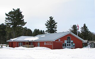
The Township of Wilmot is a rural township in the Regional Municipality of Waterloo in southwestern Ontario, Canada.

<span class="mw-page-title-main">Woolwich, Ontario</span> Township in Ontario, Canada

The Township of Woolwich is a rural township in Southwestern Ontario, Canada, considered as a municipality. The Township is located in the northeast part of Waterloo Region and is made up of 10 small communities, with Elmira, Ontario the largest and St. Jacobs, Ontario the second largest. The population at the time of the 2021 Census was 26,999, up from the 2016 population of 25,006. Waterloo Region is still home to the largest population of Old Order Mennonites in Canada, particularly in the areas around St Jacobs and Elmira. They are often seen on the local roads using their traditional horse and buggy transportation; many also use horses to pull the implements in their farm fields.

<span class="mw-page-title-main">Waterloo County, Ontario</span> Former county in Ontario, Canada

Waterloo County was a county in Canada West in the United Province of Canada from 1853 until 1867, then in the Canadian province of Ontario from 1867 until 1973. It was the direct predecessor of the Regional Municipality of Waterloo.

<span class="mw-page-title-main">Wellesley, Ontario</span> Township in Ontario, Canada

The Township of Wellesley is the rural, north-western township of the Regional Municipality of Waterloo in Ontario, Canada. It encompasses 277.79 km2 (107.26 sq mi) and had a population of 11,260 in the Canada 2016 Census.

<span class="mw-page-title-main">Nith River</span> River in Ontario, Canada

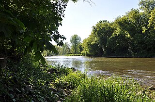
The Nith River is a river in Brant, Oxford and Perth counties and the Regional Municipality of Waterloo in Southwestern Ontario, Canada. The Nith River is approximately 125km in length and empties into the Grand River at the town of Paris. It is named after the River Nith in Scotland.

<span class="mw-page-title-main">New Hamburg, Ontario</span> Unincorporated community in Ontario, Canada

New Hamburg is a community of approximately 11,953 in the township of Wilmot, Ontario, Canada. It is in the far western part of the Regional Municipality of Waterloo, near the regional border with Perth County. It is adjacent to the community of Baden, which sits to its east and is also a part of the township of Wilmot. The nearest cities are Kitchener, Waterloo, and Stratford.

Galt is a community in Cambridge, Ontario, Canada, in the Regional Municipality of Waterloo, Ontario on the Grand River. Prior to 1973, it was an independent city, incorporated in 1915, but amalgamation with the village of Hespeler, the town of Preston and the village of Blair formed the new municipality of Cambridge. Being the largest constituent community in the city, it is also seen as the downtown core of Cambridge. The first mayor of Cambridge was Claudette Millar.

Waterloo South was a federal electoral district and a provincial electoral district in Canada.

<span class="mw-page-title-main">Preston, Ontario</span> Neighbourhood in Waterloo, Ontario, Canada

Preston is a community in Cambridge, Ontario, Canada in the Regional Municipality of Waterloo, Ontario. Prior to 1973 it was an independent town, incorporated in 1915, but amalgamation with the town of Hespeler, Ontario, the city of Galt, Ontario and the village of Blair formed the new municipality of Cambridge. Parts of the surrounding townships were also included. No population data is available for the former Preston since the Census reports cover only the full area of Cambridge, though the combined population of the census tracts covering the majority of Preston reported a population of 20,008 as of the 2016 Canada Census. The first mayor of Cambridge was Claudette Millar.

<span class="mw-page-title-main">Zorra</span> Township in Ontario, Canada

Zorra is a township in Oxford County, situated in south-western Ontario, Canada. A predominantly rural municipality, Zorra was formed in 1975 through the amalgamation of East Nissouri, West Zorra and North Oxford townships. It is best known for the Highland Games weekend held each summer in Embro, celebrating the heritage of the Scottish pioneer families which grew from the 1830s to form nearly a quarter of the county's population.

<span class="mw-page-title-main">Ayr, Ontario</span> Unincorporated community in Ontario, Canada

The community of Ayr, Ontario, Canada is located within the Township of North Dumfries in the Regional Municipality of Waterloo in Southwestern Ontario. Ayr is located south of Kitchener and west of Cambridge.

<span class="mw-page-title-main">Perth East, Ontario</span> Township in Ontario, Canada

The Township of Perth East is a municipality in Perth County, Ontario, Canada and situated north of Stratford. It was created in 1998 when the Ontario government amalgamated the village of Milverton with the surrounding former townships of Ellice, Mornington, North Easthope and South Easthope.

The Municipality of Morris-Turnberry is a municipality in Huron County, Ontario, Canada. It is located in the north portion of Huron County, near the Bruce County border, southeast of Wingham.

<span class="mw-page-title-main">Roseville, Ontario</span> Unincorporated community in Ontario, Canada

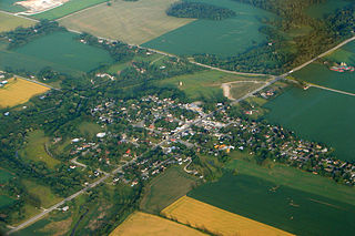
Roseville is a community in Ontario, Canada located at 43°20′35″N80°28′31″W. It is within the rural township of North Dumfries, which forms part of the Region of Waterloo, and is located between Ayr, Kitchener and Highway 401.

<span class="mw-page-title-main">Hespeler, Ontario</span> Place in Ontario, Canada

Hespeler is a neighbourhood and former town within Cambridge, Ontario, located along the Speed River in the Regional Municipality of Waterloo, Ontario, Canada. In 1973, Hespeler, Preston, Galt, and the hamlet of Blair were amalgamated to form the City of Cambridge. The first mayor of Cambridge was Claudette Millar.

References

  1. 1 2 "North Dumfries, Ontario (Code 3530004) census profile". 2011 Census of Population . Statistics Canada. Retrieved 2012-08-17.
  2. 1 2 "Census Profile, 2016 Census: North Dumfries, Township". Statistics Canada . Retrieved May 23, 2019.
  3. "Map of Township of North Dumfries" (PDF). Maps - Township of North Dumfries. Retrieved March 13, 2019.
  4. "2018 Official Plan Consolidation" (PDF). Official Plan Amendment - Township of North Dumfries. Retrieved March 13, 2019.
  5. "2018 Township Maps" (PDF). Official Plan Amendment - Township of North Dumfries. Retrieved March 13, 2019.
  6. "2018 Settlement Maps" (PDF). Official Plan Amendment - Township of North Dumfries. Retrieved March 13, 2019.
  7. "2008 Official Plan" (PDF). Official Plan Amendment - Township of North Dumfries. Retrieved March 13, 2019.
  8. "2008 Township Maps" (PDF). Official Plan Amendment - Township of North Dumfries. Retrieved March 13, 2019.
  9. 1 2 "Our Community > History". Township of North Dumfries. Archived from the original on 2011-04-23. Retrieved 2011-01-31.
  10. "CRUICKSTON PARK Cruickston Park Lane, North Dumfries near Cambridge, Ontario". House Histree. Retrieved 12 August 2023.
  11. "History of Ayr". Waterloo Region Museum. Waterloo Region. 2015. Retrieved 10 March 2017. Previous Names: Jedburgh, Mudge's Mills, Nithvale
  12. "Population and dwelling counts: Canada, provinces and territories, census divisions and census subdivisions (municipalities), Ontario". Statistics Canada. February 9, 2022. Retrieved April 2, 2022.
  13. "North Dumfries community profile". 2006 Census data . Statistics Canada. 13 March 2007. Retrieved 2011-01-31.
  14. Statistics Canada: 1996, 2001, 2006 census
  15. "2018 Election Results". www.northdumfries.ca. 2018. Retrieved December 6, 2018.