
Bristol Parkway, on the South Wales Main Line, is in the Stoke Gifford area in the northern suburbs of the Bristol conurbation. It is 112 miles (180 km) from London Paddington. The station was opened in 1972 by British Rail, and was the first in a new generation of park and ride/parkway stations. It is the third-most heavily used station in Western England, after Bristol Temple Meads and Bath Spa. There are four platforms, and a well-equipped waiting area. The station is managed by Great Western Railway, who provide most of the trains at the station, with CrossCountry providing the rest.

South Gloucestershire is a unitary authority area in South West England. It comprises multiple suburban areas to the north and east of Bristol as well as a large rural hinterland. South Gloucestershire was created in 1996 from the northern section of the county of Avon, which was abolished at that time.
Bradley Stoke is a newly developed and planned town in South Gloucestershire, England, situated on the north side of the city of Bristol, 6 miles northeast of Bristol city centre and 103 miles (166 km) due west of London. Not far from the Severn Estuary of the Bristol Channel, Bradley Stoke is bordered by three motorways; the M5 to the north, the M4 to the east and the M32 to the south.

Almondsbury is a large village near junction 16 of the M5 motorway, in South Gloucestershire, England, and a civil parish which also includes the villages of Hortham, Gaunt's Earthcott, Over, Easter Compton, Compton Greenfield, Hallen and Berwick.

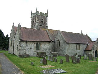
Filton is a suburban town and civil parish in South Gloucestershire, England, north of the City of Bristol and approximately 5.5 miles (9 km) from the city centre. The town centres upon Filton Church, which dates back to the 12th century and is a Grade II listed building.

Patchway is a suburban town in South Gloucestershire, England, situated 10 km (6.2 mi) north-north west of central Bristol. The town is a housing overflow for Bristol being contiguous to Bristol's urban area, and is often regarded as a large outer suburb. Nearby are the other Bristol satellite towns of Filton and Bradley Stoke. Patchway is twinned with Clermont l'Herault, France, and Gauting, Germany. It was established as a civil parish in 1953, becoming separate from the parish of nearby Almondsbury.
Stoke Gifford is a village and parish in South Gloucestershire, England, in the northern suburbs of Bristol. It had around 11,000 residents at the 2001 census, increasing to 15,494 at the 2011 census. It is home to Bristol Parkway station and Stoke Gifford depot, on the London-South Wales railway line, and the Bristol offices of Aviva which took over Friends Life in 2015, Hewlett Packard and the University of the West of England. The parish includes neighbouring Little Stoke, Harry Stoke and Stoke Park. The parish borders Filton, to the south-west, Patchway to the north west, Bradley Stoke to the north and Winterbourne and Hambrook to the east. To the south Stoke Gifford is served by the Bristol Ring Road, south of this a large green area known as the 'Green Lung' stretches to the inner city area of St Werburghs.

Little Stoke is a suburb of north Bristol, situated in South Gloucestershire, England. It is surrounded by Patchway, Stoke Gifford and Bradley Stoke. Home to Patchway railway station, a minor stop on the railway network, the railway line separates Little Stoke from the large Rolls Royce factories in nearby Filton.

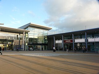
Cribbs Causeway is both a road in South Gloucestershire, England, running north of the city of Bristol, and the adjacent area which is notable for its out-of-town shopping and leisure facilities. The retail and leisure complex takes its name from the road, and includes retail parks, supermarkets, an enclosed shopping centre known as The Mall, an ice-rink, a cinema, a ten-pin bowling alley, and a gym.

Bristol North West is a constituency represented in the House of Commons of the UK Parliament since 2017 by Darren Jones of the Labour Party.

Aztec West is a business park in South Gloucestershire, England, situated in the north of Bristol, near Bradley Stoke and Patchway. It is close to the M4 and M5 motorways and the Almondsbury Interchange. Adjacent is the A38 trunk road.
Greater Bristol is a term used for the conurbation which contains and surrounds the city of Bristol in the South West of England. There is no official "Greater Bristol" authority, but the term is sometimes used by local, regional and national authorities, and others as a synonym for either the "Bristol Urban Area" or a wider area of the former County of Avon, and by some, TfGB, to refer to the Province of Bristol as defined by C. B. Fawcett (1919) or Derek Senior (1969). The Bristol post town covers a wider area than the city of Bristol.

Stoke Lodge is a suburb of Bristol, England, developed in the 1950s and early 1960s on farmland to the south of Patchway Common, South Gloucestershire and east of the A38 trunk road. Although the busy London to South Wales railway forms the south-western boundary of the estate, the sound of the trains is moderated by the railway tracks being within a cutting. The new town of Bradley Stoke lies immediately to the east, whilst the suburb of Little Stoke is on its southern edge.

The A4018 is an A-road connecting the city centre of Bristol to the M5 motorway at Cribbs Causeway. It is one of the four principal roads which link central Bristol to the motorway network.
Charlton was the name of a small village or large hamlet in Gloucestershire, England with a Bethel Chapel and Sunday School. It was demolished in the late 1940s. Its site is occupied by part of the derelict runway and safety margins of the former Bristol Filton Airport. The village was located between Filton and what is today the Cribbs Causeway out-of-town commercial and retail area immediately north of Bristol. To the north of the village lay fields and Over Court Deer Park. which is today Bristol Golf Club.
Bristol is a city in south west England, situated near the Bristol Channel coast, approximately 106 miles (170 km) west of London. Several factors have influenced the development of its transport network. It is a major centre of employment, retail, culture and higher education, has many historic areas, and has a history of maritime industry. The city has a population of 450,000, with a metropolitan area of 650,000, and lies at the centre of the former County of Avon, which includes many dormitory towns, and has a population of one million. Additionally, it has the seventh highest population density of any English district.

Bristol Supertram was a proposed light rail system for the Bristol and South Gloucestershire regions of England. In 2001, the project was given backing from the government to build a line that would link the city centre with the North Bristol region, but the project was cancelled in 2004.
This article lists proposed developments to transport in Bristol, England.
Charlton Hayes is a British mixed-use development located on land north of Filton Airfield and is a new extension to Patchway. Planning permission was granted by the South Gloucestershire Council in 2008 to build 2,200 homes for 6,000 residents. Charlton Hayes was named after the village of Charlton, which was demolished to make way for Filton Airfield extension.

MetroBus is a bus rapid transit system in Bristol, England. It is a joint project between Bristol, North Somerset and South Gloucestershire councils. The first route, service m3, began operations on 29 May 2018, followed by m2 on 3 September and m1 on 6 January 2019.
