North Lantau Highway

Last updated

HK Route8.svg
North Lantau Highway
Part of Route 8
North Lantau Highway map.svg
North Lantau Highway coloured red
Route information
Maintained by Highways Department
Length12.8 km (8.0 mi)
Existed1997–present
Major junctions
West end Chek Lap Kok
East end Lantau (near Yam O)
Location
Country China
Special administrative region Hong Kong
Highway system
North Lantau Highway
Traditional Chinese 北大嶼山公路
Simplified Chinese 北大屿山公路
Hong Kong road sign (Expressway Begins).svg North Lantau Highway
DistrictLocationkmInterchange nameExitDestinationsNotes
Islands Chek Lap Kok 0.0 Airport Road  Airport Aircraft Airport ecomo.svg Western terminus; start of Route 8 distance markers.
Tung Chung 0.4Start of expressway; western terminus of Route 8.
0.66CTung Chung Waterfront Road Tung Chung (North) Westbound exit and eastbound entrance
Formerly numbered 6B
1.6Tung Chung Eastern Interchange6BYu Tung Road Tung Chung Town Centre, Tung Chung (West) Westbound exit and eastbound entrance
Formerly numbered 6A
Siu Ho Wan 3.46A Shun Long Road  Tuen Mun, Zhuhai, Macao Eastbound exit and westbound entrance
Linkage to the Hong Kong–Zhuhai–Macau Bridge and Tuen Mun-Chek Lap Kok Link
4.8Siu Ho Wan Interchange6Unnamed access road – Siu Ho Wan MTR Depot
5.45A Shun Long Road  Zhuhai, Macao Westbound exit and eastbound entrance
Linkage to the Hong Kong–Zhuhai–Macau Bridge
Tsuen Wan Yam O 11.3Sunny Bay Interchange5 Hong Kong road sign (Expressway Begins).svg Penny's Bay Highway  Disneyland Resort, Sunny Bay
Tsing Chau Tsai 12.9 Lantau Toll Plaza Hong Kong road sign (Expressway Begins).svg Lantau Link  Tsing Yi, Kowloon, Hong Kong Eastern terminus (at toll booths); HK Route8.svg Route 8 continues
1.000 mi = 1.609 km; 1.000 km = 0.621 mi

Traffic

The Transport Department offers traffic figures at two sections of the North Lantau Highway. The section between the western end of the highway (i.e. Airport Road) and the Tung Chung Eastern Interchange registered annual average daily traffic (AADT) of 54,410 in 2016. The section between Tung Chung and Ngong Shuen Au was busier, carrying 66,110 AADT in 2016. [10]

Traffic on the highway has increased in recent years. Some residents and legislators have raised concerns that the new Hong Kong–Zhuhai–Macau Bridge (see below) will increase traffic congestion. [11]

Current developments

A new interchange at Tai Ho Wan is under construction. This will connect the North Lantau Expressway to the Border Crossing Facilities Island (BCF Island), a new artificial island being built as part of the controversial Hong Kong–Zhuhai–Macau Bridge project. The connection between the new island and the North Lantau Expressway is actually being built under the Tuen Mun–Chek Lap Kok Link project, a new road tunnel connecting Tuen Mun to the BCF Island.

From the new interchange, a two-lane dual carriageway will run on viaducts, over the sea, to the BCF Island. The project (including the viaducts, the interchange, and modifications to the North Lantau Highway and Cheung Tung Road) is being built by Hong Kong contractor Gammon Construction for a contract value of HK$8.66 billion. The Highways Departments expects this to be complete by 2019. [12]

Related Research Articles

<span class="mw-page-title-main">Tsing Ma Bridge</span> Suspension bridge in Hong Kong

Tsing Ma Bridge is a bridge in Hong Kong. It is the world's 16th-longest span suspension bridge, and was the second longest at time of completion. The bridge was named after the two islands it connects, namely Tsing Yi and Ma Wan. It has two decks and carries both road and rail traffic, which also makes it the largest suspension bridge of this type. The bridge has a main span of 1,377 metres (4,518 ft) and a height of 206 metres (676 ft). The span is the longest of all bridges in the world carrying rail traffic.

<span class="mw-page-title-main">Lantau Island</span> Largest island in Hong Kong

Lantau Island is the largest island in Hong Kong, located West of Hong Kong Island and the Kowloon Peninsula, and is part of the New Territories. Administratively, most of Lantau Island is part of the Islands District of Hong Kong. A small northeastern portion of the island is located in the Tsuen Wan District.

<span class="mw-page-title-main">Islands District</span> District in Hong Kong, China

The Islands District is one of the 18 districts of Hong Kong. It is part of the New Territories. It had a population of 170,900 in 2018.

<span class="mw-page-title-main">Tung Chung</span> New town in Hong Kong

Tung Chung, meaning "eastern stream", is an area on the northwestern coast of Lantau Island, Hong Kong. One of the most recent new towns, it was formerly a rural fishing village beside Tung Chung Bay, and along the delta and lower courses of Tung Chung River and Ma Wan Chung in the north-western coast of Lantau Island. The area was once an important defence stronghold against pirates and foreign military during the Ming and the Qing dynasties.

<span class="mw-page-title-main">Tung Chung line</span> Hong Kong MTR railway line

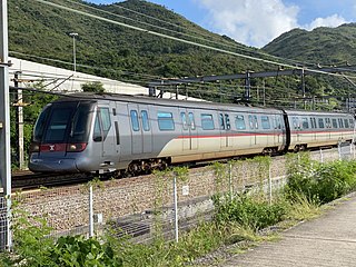
The Tung Chung line is one of the ten lines of the MTR system in Hong Kong, linking the town of Tung Chung with central Hong Kong. A part of the Tung Chung line was built along with the Kap Shui Mun Bridge and the Tsing Ma Bridge. The line currently travels through eight stations in 31 minutes along its route. The line is coloured orange on the map.

<span class="mw-page-title-main">Lantau Link</span> Road linking western and central Hong Kong

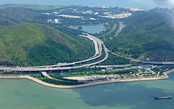
The Lantau Link, formerly known as the Lantau Fixed Crossing, is a roadway in Hong Kong forming part of Route 8 linking Lantau Island to Tsing Yi, from which other roads lead to the urban areas of Kowloon and the rest of the New Territories. Part of the Airport Core Programme centred on the new Hong Kong International Airport on Lantau, the link was officially opened on 27 April 1997, and it opened to traffic on 22 May the same year.

<span class="mw-page-title-main">Chek Lap Kok</span> Island in New Territories, Hong Kong

Chek Lap Kok is an island in the western waters of Hong Kong's New Territories. Unlike the smaller Lam Chau, it was only partially leveled when it was assimilated via land reclamation into the 12.48 square kilometres (4.82 sq mi) island for the current Hong Kong International Airport, which opened for commercial aviation in 1998. The airport is popularly referred to as Chek Lap Kok Airport to distinguish it from the former Hong Kong International Airport, now commonly known as Kai Tak Airport (啟德機場).

<span class="mw-page-title-main">Route 8 (Hong Kong)</span> Road in Hong Kong

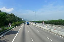
Route 8 of Hong Kong is a dual 3-lane carriageway motorway that links Lantau Island, Tsing Yi Island, Cheung Sha Wan in West Kowloon, and Sha Tin in the southeast New Territories of Hong Kong. It is a combination of many sections.

<span class="mw-page-title-main">Airport Core Programme</span>

The Airport Core Programme was a series of infrastructure projects centred on the new Hong Kong International Airport during the early 1990s. The programme was part of the Port and Airport Development Strategy, commonly known as the Rose Garden Project.

<span class="mw-page-title-main">Route 3 (Hong Kong)</span> Road in Hong Kong

Route 3 is a series of expressways in Hong Kong that runs from Sai Ying Pun on Hong Kong Island to Yuen Long in the New Territories, linking West Kowloon, Kwai Chung and Tsing Yi. It was built as part of the Airport Core Programme to provide access to Hong Kong International Airport from the city, and to relieve congestion in the New Territories. The Western Harbour Crossing and Tai Lam Tunnel that form part of the route are tollways.

<span class="mw-page-title-main">Urmston Road</span>

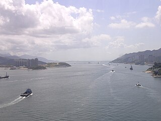
Urmston Road is a broad body of water between Lantau Island and Tuen Mun in Hong Kong. It forms an inshore passage between the northwest end of Victoria Harbour and the mouth of the Pearl River. At its eastern end it connects to the Western Working Anchorage through the Ma Wan Channel and the narrower Kap Shui Mun channel to the west of Ma Wan.

<span class="mw-page-title-main">Hong Kong Strategic Route and Exit Number System</span> Trunk road numbering system in Hong Kong

The Hong Kong Strategic Route and Exit Number System is a system adopted by the Transport Department of the Hong Kong Government to organise the major roads in the territory into routes 1 to 10 for the convenience of drivers. When the system was implemented in 2004, the government promoted it with a major public campaign, including the slogan "Remember the Numbers; Make Driving Easier".

<span class="mw-page-title-main">Ma Wan Viaduct</span> Bridge

Ma Wan Viaduct is a viaduct built over Ma Wan, an island in Hong Kong. The viaduct connects the Tsing Ma Bridge and Kap Shui Mun Bridge with an exit to Ma Wan Road, and is part of the Lantau Link and Route 8. It was opened on 22 May 1997 and was built to provide access to the Hong Kong International Airport as part of the Airport Core Programme.

<span class="mw-page-title-main">Siu Ho Wan</span>

Siu Ho Wan is a bay on the north shore of Lantau Island in Hong Kong. The bay has been largely reclaimed for bus depots. The Airport Express, Tung Chung line of the MTR and the North Lantau Highway run across the reclamation of the bay. The Siu Ho Wan MTR depot lies on the reclaimed shore between Ngau Kok Wan and is currently used by Airport Express, Tung Chung line and Disneyland Resort line.

<span class="mw-page-title-main">Tai Ho Wan</span> Bay of Hong Kong

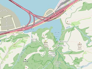
Tai Ho Wan or Tai Ho Bay is a bay on the north shore of Lantau Island in the New Territories of Hong Kong. It is located west of Siu Ho Wan, and northeast of Tung Chung and Kei Tau Kok. The surrounding land was originally planned to be part of the North Lantau New Town scope, but there is a current slowdown in its plans because of the lack in population growth and environmental groups opposed to the next in abeyance.

<span class="mw-page-title-main">Tuen Mun–Chek Lap Kok Link</span>

The Tuen Mun–Chek Lap Kok Link is a road project in the New Territories, Hong Kong. It comprises two elements: the "Northern Connection" and the "Southern Connection". The Northern Connection comprises an undersea tunnel crossing the Urmston Road, linking Tuen Mun to the "Boundary Crossing Facilities" (BCF), an artificial peninsula connected to Hong Kong International Airport. The Southern Connection, officially named Shun Long Road, comprises viaducts linking the BCF to North Lantau Highway on Lantau Island.

References

  1. 1 2 "North Lantau Expressway". Hong Kong Airport Core Programme. New Airport Projects Co-ordination Office, Government Secretariat. Retrieved 19 February 2018.
  2. 1 2 3 4 5 Lloyd, R.H. (1998). "Design and construction of the West Kowloon Expressway, Kwai Chung and Tsing yi section of Route 3 and the North Lantau Expressway". Proceedings of the Institution of Civil Engineers. 126 (6): 16–34. ISSN   1751-7672.
  3. Yue, S.Y. (7 March 1992). "Expressway contract split to help locals". South China Morning Post . p. 5.
  4. 1 2 "List of Current Contracts as at 31/12/96". Hong Kong Airport Core Programme. New Airport Projects Co-ordination Office, Government Secretariat. Retrieved 19 February 2018.
  5. "Tai Ho route almost finished". South China Morning Post. 28 October 1993.
  6. Delfino, Brendan (22 May 1997). "Drivers' beef with new road". South China Morning Post. p. 4.
  7. "百年一遇 暴雨沖潰機場命脈 北大嶼山公路成河道 交通癱瘓10小時". Ming Pao. 8 June 2008.
  8. "洪水五秒癱瘓機場公路". Sing Tao Daily. 8 June 2008.
  9. "Work on highway split into three". South China Morning Post. 14 October 1991.
  10. "The Annual Traffic Census 2016" (PDF). Transport Department. August 2017.
  11. Clark, Robert (18 January 2018). "N. Lantau Highway traffic up 40% over four years". Lantau News.
  12. "Contract No. HY/2012/07 Tuen Mun–Chek Lap Kok Link Southern Connection Viaduct Section". Highways Department. Retrieved 19 February 2018.

22°18′51″N113°59′33″E / 22.3143°N 113.9924°E / 22.3143; 113.9924

Preceded by
Lantau Link
Hong Kong Route 8
HK Route8.svg
North Lantau Highway
Succeeded by
Western Terminus