Northern North Sea basin

Last updated
Map of the North Sea North Sea map-en.png
Map of the North Sea

The North Sea is part of the Atlantic Ocean in northern Europe. It is located between Norway and Denmark in the east, Scotland and England in the west, Germany, the Netherlands, Belgium and France in the south.

Contents

The geology of the North Sea describes the geological features such as channels, trenches, and ridges today and the geological history, plate tectonics, geological events that created them.

A geological basin is a large low-lying area or depression. It is often below sea level. Depressions are typically formed by tectonic processes acting on the lithosphere, providing "accommodation space" for sediment to be preserved. Basins are formed in a variety of tectonic settings: extensional, compressional, strike-slip and intraplate.

Geological basins are one of the most common places which collect sediment. The type of rocks which form there tell about the palaeoclimate of the continent. The geology is of interest to oil prospectors, hydrologists and palaeontologists. Exploration in the North Sea was initiated in May 1964 when the first well was spudded and the area has now become one of the most prolific hydrocarbon provinces in the world. [1] Total recoverable reserves found to date, including adjacent land areas, amount to over 100 billion barrels of oil and natural gas. [2]

Geologically speaking, the North Sea is divided into four main basins: Northern, Moray Firth, Central, and Southern. Each has a long and complex geologic history with unique structural and stratigraphic developments driven by tectonic events over the last 400 Million years. [1] The northern North Sea Paleorift system, including the Viking and Sogn graben, is an approximately 150–200 km wide zone of extended upper crust with preserved strata from pre-Triassic to Tertiary. It is bounded by the Shetland Platform to the west and the Norwegian mainland to the east. [3]

Evolutionary outline

The most important events in the geological evolution of the North Sea are outlined as: [1]

  1. Precambrian events - formation of Highlands and basement elements.
  2. The Caledonian plate cycle - Late Cambrian to Late Silurian Athollian and Caledonian Orogenies.
  3. The Variscan plate cycle - Devono-Carboniferous rifting, Variscan Orogency, and creation of the Pangaea supercontinent.
  4. Permo-Triassic rifting and thermal subsidence - Late Permian subsidence of the Moray Firth and east-west trending of the Permian Basin. Subsequent Triassic to early Jurassic thermal subsidence was abruptly terminated by a phase of Middle Jurassic thermal doming.
  5. Middle Jurassic domal uplift - development of transient mantle plume head leading to erosion of central North Sea, volcanism, and subsequent rift system.
  6. Late Jurassic to earliest Cretaceous extensional tectonics - led to fault-block rotations and formation of major structural traps within and adjacent to the Viking and Central Grabens. In contrast to areas west of Shetland, the phase of extensional basin development was followed by a phase of post-rift thermal subsidence in the North Sea during the later Cretaceous and Cenozoic.
  7. Development of the Iceland hot spot and North Atlantic rifting - during the Cretaceous, the onset of sea-floor spreading in the North Atlantic Ocean superseded North Sea tectonics. Opening of the Atlantic Ocean and the development of the Iceland hot spot were major factors in Cenozoic uplift and exhumation of the British Isles. This caused regional tilt, affecting the western rift arm of the North Sea and Inner Moray Firth.
  8. Tectonic Inversion of Mesozoic basin - creation of the Atlantic Ocean caused intraplate compression, leading to the tectonic inversion of former sedimentary basins across north-west Europe during the Late Cretaceous and Tertiary.

In general, pre-Triassic stratigraphy and rifting has been confirmed [4] [5] below the northern North Sea but is poorly known and little conclusive information exists about Devonian and Carboniferous extensional events. While precise dating and the spatial extent of the active stretching are uncertain, recent stratigraphic syntheses suggest syn-rift dates of no younger than Scythian, with a possible initiation during the late or even early Permian. [6] [7] The following middle Triassic to early Jurassic post-rift stage is considerable better known. Subsidence (approximately nine intervals) [8] in the northern North Sea was accompanied by faulting, stepping down from both margins towards the present Viking Graben axis. [7] Depositional environments pass from continental to marine, implying that the creation of new accommodation space outpaced sediment supply. It is likely that this was at least partly in response to thermal subsidence. [3] The late Jurassic-early Cretaceous stretching event is also well constrained. Rotational movements on major fault zones bounding the northern Viking Graben commenced in the latest Bajocian-earliest Bathonian and ceased in the earliest Ryazanian. [9] [10] [11] The depositional environments pass from coastal plain and shallow marine on the platforms and terraces bordering the Viking graben to deeper marine in the interior of the graben system. [1] The Cretaceous-early Cenozoic succession in the northern North Sea largely represents post-rift infill, resulting from subsidence in response to lithospheric cooling following the late Jurassic-early Cretaceous stretching event. [12] [13] Subsequent Tertiary subsidence was segmented and interrupted by basin flank uplifts, whereas in the early Miocene the entire northernmost North Sea area became uplifted and eroded as a result of compressional tectonics in the Norwegian Sea. [14]

Tectonostratigraphic model

McKenzie model (pure shear) McKenzie model.png
McKenzie model (pure shear)

In the northern North Sea, despite the substantial amount of data available, our understanding of the lithospheric processes governing extension are strongly model-based. The architecture and signature of the sediment infill in the northern North Sea can be discussed in the context of three distinct evolutionary stages of rift basin development separated by key geologic unconformities. The proto-rift stage describes the rift onset with either doming or flexural subsidence. Tabular architectures thickening across relatively steep faults, characterize the proto-rift stage. Active stretching and rotation of fault blocks then occurs during the main rift stage is then terminated by the development of the syn-rift unconformity. Syn-rift architectures can be highly variable depending on the ability of the available sediment supply to fill accommodation formed by rotation and subsidence during this stage. Where crustal separation is accomplished, a break-up unconformity commonly marks the boundary to the overlying thermal relaxation of post-rift stage. During the post-rift stage, an early phase with coarse clastic infilling of remnant rift topography often precedes late stage widening of the basin and filling with fine-grained sediments. [3] These processes have been attributed to pure shear [15] (crustal extension and faulting in the upper crust) and simple shear [16] (ductile stretching in the lower crust) and coupled simple shear/pure shear flexural deformation. The combined thermal and elastic/isostatic response of the lithosphere to extension controls the crustal architecture and thereby the geometry of sedimentary basins, including those of the northern North Sea. [17]

Proto-rift stage

The proto-rift stage is sometimes characterized by deposition in a wide, slowly subsiding flexural basin with only minor fault activity. During this stage, sedimentation is controlled primarily by climatic and, in marine settings, by relative sea-level fluctuations. In other rifts, progressive, thermally induced, upward displacement of the asthenosphere - lithosphere boundary by mantle plumes cause the gradual upward motion of broad rift domes that reach their maximum dimensions before or at the onset of active stretching. [3] Proto-rift basins are typically saucer-shaped, slightly deepening towards the future graben axis, which can lead to large axial sediment transport systems. [3] [18] Domal uplift can occur contemporaneously with incipient subsidence in different segments of a proto-rift structure.

The evolution of the Brent Delta System of the northern North Sea follows this model. [19] [20] Deposition of the Brent Group has been coupled with the growth and erosion of a mid-North Sea dome, [21] [22] as well as with non-dome related tectonics along the northern North Sea rift margins. [8] As domal uplift related to incipient rifting is commonly associated with subsidence in its vicinity, erosional products tend to accumulate in associated depositional basins that may be a proto-rift, as with the Brent Delta system. [3] A proto rift unconformity also develops in this situation as seen in the southern and central parts of the palaeorift system where domal structures were deeply eroded in the middle Jurassic [21] [22] which is known as the 'Mid-Cimmerian' unconformity. [23]

Main rift stage

The main rift or "syn-rift" stage describes the phase of active stretching and fault block rotation. Syn-rift subsidence results from the elastic/isostatic adjustment of the crust due to mechanical stretching of the lithosphere. [3] The subsidence is counteracted by upwelling of the asthenosphere into the space created by the mechanical stretching and thermal upward displacement of the asthenosphere-lithosphere boundary, causing uplift of the rift zone. [24] [16] [25] The fundamental architectural element in many extensional basins is the half-graben, formed within the hanging walls of major rift-bounding or intra-rift basin faults. The location and number of half grabens are influenced by the position of the main faults and the width of the rift zone, which depends on the rheology, crustal thickness and stretching factors. [3]

Half-graben and wedge-shaped infill geometries characterize both the Permo-Triassic and late Jurassic stretching events in the northern North Sea, most prominently in the area southwest of the Brent Field. [23] This area shows a high degree of three-dimensional variability with an intermixing of proto-rift and post-rift geometries. More evidence of progressive rift climax with divergent stratal patterns occurs across the major eastern boundary fault of the East Shetland Platform. [3] Another example from the Permo-Triassic succession on the Horda Platform shows fault-bounded, wedge-shaped units from this time period. [7] The amount of divergence suggests maximum tilt rates and rift climax during deposition of the Permian to early Triassic unit. A late-rift or rift relaxation sub-stage has also been interpreted in the evolution and filling of the Oslo Graben. [26] Variable rates of rotation across individual fault blocks initiated by subsidence have been interpreted in the upper Jurassic infill across the Oseberg Field. Several rotational maxima led to the deposition of wedge-shaped units downflank in hanging wall positions, in response to footwall crestal uplift and erosion. Interbedded tabular units were deposited during periods of general tectonic subsidence and minor rotation. Because the sedimentary infilling is a response to this tectonic scenario, a pattern of syn-rift architecture is recognizable, although it can be obscured by variation in sediment supply and sea-level. [3] In the late-Jurassic sub-basins of the Northern North Sea, syn-rift units which develop in the hanging wall infill consist of basal units of turbiditic sandstones and overlying shales which are sometimes also capped by marine and coastal plain sandstones if the sediment supply is sufficient. [27] Examples of this type of architecture are illustrated in the main rift units of Statfjord North and Gyda Fields. [10] The Visund fault block and the Oseberg-Brage infill are examples from marine half-grabens which are near the central or axial zones of the northern North Sea rift complex, far from the main hinterland areas and show deepening upward trends into basinal shales. [3]

The syn-rift unconformity describes the erosion surface that bevels fault blocks during continental rifting. It develops locally over individual fault blocks because of footwall uplift and lithospheric unloading by extension. [28] [25] The syn-rift unconformity separates the rift from the following post-rift stage and, with the exception of faulted terrain, it is the most pronounced feature of rift basins. A northern North Sea example is in the Snorre Field where its crestal part was exposed to subaerial and subaqueous erosion during much of the late Jurassic and as much as 1 km of sediments has been removed in the northern part of the block. [29] Other fault blocks in the North Sea, such as the Oseberg fault block, have rounded or flat tops resulting from erosion and peneplanation down to sea level. [3]

Post-rift stage

Lithospheric extension and rift basin formation are followed by an asymptotically decreasing post-rift subsidence, caused by thermal contraction and relaxation of the heated crust. Such thermal subsidence typically spans about 100 Ma before thermal equilibrium is reached. [3] This process typically occurs over a wider area than the original syn-rift subsidence, resulting in an elongated, saucer-shaped basing morphology and onlapping of post-rift strata against basin margins as well as onto remnant syn-rift topography. [30]

The major bounding faults of the northern North Sea palaeorift system, the East Shetland and Oygarden Fault Zones, are examples of such long-lived fault zones. In addition, the Viking Graben master faults bounding the East Shetland Platform to the west and the Horda Platform to the east acted as frontal shoulder faults during late Jurassic-early Cretaceous rifting. [3] The early Cretaceous post-rift phase in the northern North Sea was characterized by slow subsidence, with much of the sedimentation accommodated by the infilling of previous rift bathymetry. At this time the shoulders of the rift were supported. [31] During latest Cretaceous and Tertiary the shoulders lost their support, producing elongated, saucer-shaped basin and a 'steer's head' cross-sectional basin shape.

Sediment architectures resulting from post-rift subsidence are generally much more simple than those produced during active stretching. Because maximum subsidence occur along the rift axis, post-rift successions tend to have a backstepping character. This is accentuated by a common decrease in sediment input as drainage basins become eroded and lose their significance. The gradual passage from continental coarse clastic sediments into shallow marine shales in the middle Triassic-lower Jurassic post-rift succession in the northern North Sea serves as a good example of such a model. During the Cretaceous, low-relief drainage areas are completely transgressed and the clastic supply is shut off. A return to clastic sedimentation is seen in the Tertiary post-rift filling of the North Sea which is related to compaction and external tectonics. [3]

Related Research Articles

<span class="mw-page-title-main">Sedimentary basin</span> Regions of long-term subsidence creating space for infilling by sediments

Sedimentary basins are region-scale depressions of the Earth's crust where subsidence has occurred and a thick sequence of sediments have accumulated to form a large three-dimensional body of sedimentary rock. They form when long-term subsidence creates a regional depression that provides accommodation space for accumulation of sediments. Over millions or tens or hundreds of millions of years the deposition of sediment, primarily gravity-driven transportation of water-borne eroded material, acts to fill the depression. As the sediments are buried, they are subject to increasing pressure and begin the processes of compaction and lithification that transform them into sedimentary rock.

<span class="mw-page-title-main">Rift</span> Geological linear zone where the lithosphere is being pulled apart

In geology, a rift is a linear zone where the lithosphere is being pulled apart and is an example of extensional tectonics. Typical rift features are a central linear downfaulted depression, called a graben, or more commonly a half-graben with normal faulting and rift-flank uplifts mainly on one side. Where rifts remain above sea level they form a rift valley, which may be filled by water forming a rift lake. The axis of the rift area may contain volcanic rocks, and active volcanism is a part of many, but not all, active rift systems.

<span class="mw-page-title-main">Foreland basin</span> Structural basin that develops adjacent and parallel to a mountain belt

A foreland basin is a structural basin that develops adjacent and parallel to a mountain belt. Foreland basins form because the immense mass created by crustal thickening associated with the evolution of a mountain belt causes the lithosphere to bend, by a process known as lithospheric flexure. The width and depth of the foreland basin is determined by the flexural rigidity of the underlying lithosphere, and the characteristics of the mountain belt. The foreland basin receives sediment that is eroded off the adjacent mountain belt, filling with thick sedimentary successions that thin away from the mountain belt. Foreland basins represent an endmember basin type, the other being rift basins. Space for sediments is provided by loading and downflexure to form foreland basins, in contrast to rift basins, where accommodation space is generated by lithospheric extension.

<span class="mw-page-title-main">Porcupine Seabight</span> Deep-water oceanic basin on the continental margin of the northeastern Atlantic

The Porcupine Seabight or Porcupine Basin is a deep-water oceanic basin located on the continental margin in the northeastern portion of the Atlantic Ocean. It can be found in the southwestern offshore portion of Ireland and is part of a series of interconnected basins linked to a failed rift structure associated with the opening of the Northern Atlantic Ocean. The basin extends in a North-South direction and was formed during numerous subsidence and rifting periods between the Late Carboniferous and Late Cretaceous. It is bordered by the

The Cheshire Basin is a late Palaeozoic and Mesozoic sedimentary basin extending under most of the county of Cheshire in northwest England. It extends northwards into the Manchester area and south into Shropshire. The basin possesses something of the character of a half-graben as its deepest extent is along its eastern and southeastern margins, where it is well defined by a series of sub-parallel faults, most important of which is the Red Rock Fault. These faults divide the basin from the older Carboniferous rocks of the Peak District and the North Staffordshire Coalfield.

<span class="mw-page-title-main">Geology of the Pyrenees</span> European regional geology

The Pyrenees are a 430-kilometre-long, roughly east–west striking, intracontinental mountain chain that divide France, Spain, and Andorra. The belt has an extended, polycyclic geological evolution dating back to the Precambrian. The chain's present configuration is due to the collision between the microcontinent Iberia and the southwestern promontory of the European Plate. The two continents were approaching each other since the onset of the Upper Cretaceous (Albian/Cenomanian) about 100 million years ago and were consequently colliding during the Paleogene (Eocene/Oligocene) 55 to 25 million years ago. After its uplift, the chain experienced intense erosion and isostatic readjustments. A cross-section through the chain shows an asymmetric flower-like structure with steeper dips on the French side. The Pyrenees are not solely the result of compressional forces, but also show an important sinistral shearing.

<span class="mw-page-title-main">Jeanne d'Arc Basin</span>

The Jeanne d'Arc Basin is an offshore sedimentary basin located about 340 kilometres to the basin centre, east-southeast of St. John's, Newfoundland and Labrador. This basin formed in response to the large scale plate tectonic forces that ripped apart the super-continent Pangea and also led to sea-floor spreading in the North Atlantic Ocean. This basin is one of a series of rift basins that are located on the broad, shallow promontory of continental crust known as the Grand Banks of Newfoundland off Canada's east coast. The basin was named after a purported 20 metres shoal labelled as "Ste. Jeanne d'Arc" on out-dated bathymetric charts and which was once thought to represent a local exposure of basement rocks similar to the Virgin Rocks.

The South China Sea Basin is one of the largest marginal basins in Asia. South China Sea is located to the east of Vietnam, west of Philippines and the Luzon Strait, and north of Borneo. Tectonically, it is surrounded by the Indochina Block on the west, Philippine Sea Plate on the east, Yangtze Block to the north. A subduction boundary exists between the Philippine Sea Plate and the Asian Plate. The formation of the South China Sea Basin was closely related with the collision between the Indian Plate and Eurasian Plates. The collision thickened the continental crust and changed the elevation of the topography from the Himalayan orogenic zone to the South China Sea, especially around the Tibetan Plateau. The location of the South China Sea makes it a product of several tectonic events. All the plates around the South China Sea Basin underwent clockwise rotation, subduction and experienced an extrusion process from the early Cenozoic to the Late Miocene.

The Exmouth Plateau is an elongate northeast striking extensional passive margin located in the Indian Ocean roughly 3,000 meters offshore from western and northwestern Western Australia.

<span class="mw-page-title-main">Gulf of Mexico basin</span> Oceanic rift basin

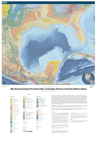
The formation of the Gulf of Mexico, an oceanic rift basin located between North America and the Yucatan Block, was preceded by the breakup of the Supercontinent Pangaea in the Late-Triassic, weakening the lithosphere. Rifting between the North and South American plates continued in the Early-Jurassic, approximately 160 million years ago, and formation of the Gulf of Mexico, including subsidence due to crustal thinning, was complete by 140 Ma. Stratigraphy of the basin, which can be split into several regions, includes sediments deposited from the Jurassic through the Holocene, currently totaling a thickness between 15 and 20 kilometers.

<span class="mw-page-title-main">Adare Basin</span>

The Adare Basin is a geologic structural basin located north-east of Cape Adare of Antarctica, for which its named, and north of the western Ross Sea. The Adare Basin is an extensional rift basin located along a seafloor spreading center that forms the failed arm of the Tertiary spreading ridge separating East and West Antarctica, known as the West Antarctic Rift System and similar in structure to the East Africa Rift System. Centrally located in the Adare Basin is the Adare Trough. The extension of this rift system is recorded in a series of magnetic anomalies which run along the seafloor at the extinct, north–south trending, Adare spreading axis. The Adare spreading system continues unbroken into the Northern Basin underlying the adjacent Ross Sea continental shelf.

<span class="mw-page-title-main">Geology of the southern North Sea</span> Largest gas producing basin

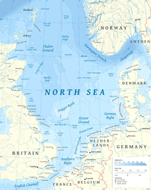
The North Sea basin is located in northern Europe and lies between the United Kingdom, and Norway just north of The Netherlands and can be divided into many sub-basins. The Southern North Sea basin is the largest gas producing basin in the UK continental shelf, with production coming from the lower Permian sandstones which are sealed by the upper Zechstein salt. The evolution of the North Sea basin occurred through multiple stages throughout the geologic timeline. First the creation of the Sub-Cambrian peneplain, followed by the Caledonian Orogeny in the late Silurian and early Devonian. Rift phases occurred in the late Paleozoic and early Mesozoic which allowed the opening of the northeastern Atlantic. Differential uplift occurred in the late Paleogene and Neogene. The geology of the Southern North Sea basin has a complex history of basinal subsidence that had occurred in the Paleozoic, Mesozoic, and Cenozoic. Uplift events occurred which were then followed by crustal extension which allowed rocks to become folded and faulted late in the Paleozoic. Tectonic movements allowed for halokinesis to occur with more uplift in the Mesozoic followed by a major phase of inversion occurred in the Cenozoic affecting many basins in northwestern Europe. The overall saucer-shaped geometry of the southern North Sea Basin indicates that the major faults have not been actively controlling sediment distribution.

<span class="mw-page-title-main">North German basin</span> Passive-active rift basin in central and west Europe

The North German Basin is a passive-active rift basin located in central and west Europe, lying within the southeasternmost portions of the North Sea and the southwestern Baltic Sea and across terrestrial portions of northern Germany, Netherlands, and Poland. The North German Basin is a sub-basin of the Southern Permian Basin, that accounts for a composite of intra-continental basins composed of Permian to Cenozoic sediments, which have accumulated to thicknesses around 10–12 kilometres (6–7.5 mi). The complex evolution of the basin takes place from the Permian to the Cenozoic, and is largely influenced by multiple stages of rifting, subsidence, and salt tectonic events. The North German Basin also accounts for a significant amount of Western Europe's natural gas resources, including one of the world's largest natural gas reservoir, the Groningen gas field.

<span class="mw-page-title-main">Kutai Basin</span>

The Kutai sedimentary basin extends from the central highlands of Borneo, across the eastern coast of the island and into the Makassar Strait. With an area of 60,000 km2, and depths up to 15 km, the Kutai is the largest and deepest Tertiary age basin in Indonesia. Plate tectonic evolution in the Indonesian region of SE Asia has produced a diverse array of basins in the Cenozoic. The Kutai is an extensional basin in a general foreland setting. Its geologic evolution begins in the mid Eocene and involves phases of extension and rifting, thermal sag, and isostatic subsidence. Rapid, high volume, sedimentation related to uplift and inversion began in the Early Miocene. The different stages of Kutai basin evolution can be roughly correlated to regional and local tectonic events. It is also likely that regional climate, namely the onset of the equatorial ever wet monsoon in early Miocene, has affected the geologic evolution of Borneo and the Kutai basin through the present day. Basin fill is ongoing in the lower Kutai basin, as the modern Mahakam River delta progrades east across the continental shelf of Borneo.

<span class="mw-page-title-main">Tarfaya Basin</span>

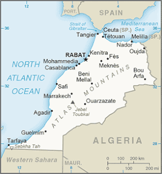
The Tarfaya Basin is a structural basin located in southern Morocco that extends westward into the Moroccan territorial waters in the Atlantic Ocean. The basin is named for the city of Tarfaya located near the border of Western Sahara, a region governed by the Kingdom of Morocco. The Canary Islands form the western edge of the basin and lie approximately 100 km to the west.

<span class="mw-page-title-main">Wessex Basin</span> Petroliferous geological area on the southern coast of England and the English Channel

The Wessex Basin is a petroleum-bearing geological area located along the southern coast of England and extending into the English Channel. The onshore part of the basin covers approximately 20,000 km2 and the area that encompasses the English Channel is of similar size. The basin is a rift basin that was created during the Permian to early Cretaceous in response to movement of the African plate relative to the Eurasian plate. In the late Cretaceous, and again in the Cenozoic, the basin was inverted as a distant effect of the Alpine orogeny. The basin is usually divided into 3 main sub-basins including the Winterborne-Kingston Trough, Channel Basin, and Vale of Pewsey Basin. The area is also rich in hydrocarbons with several offshore wells in the area. With the large interest in the hydrocarbon exploration of the area, data became more readily available, which improved the understanding of the type of inversion tectonics that characterize this basin.

<span class="mw-page-title-main">Hebron-Ben Nevis oil field</span> Oil field off the coast of Newfoundland

Hebron Oil Field, located off the coast of Newfoundland, is the fourth field to come on to production in the Jeanne d'Arc Basin. Discovered in 1981 and put online in 2017, the Hebron field is estimated to contain over 700 million barrels of producible hydrocarbons. The field is contained within a fault-bounded Mesozoic rift basin called the Jeanne d'Arc Basin.

The Otway Basin is a northwest trending sedimentary basin located along the southern coast of Australia. The basin covers an area of 150,000 square kilometers and spans from southeastern South Australia to southwestern Victoria, with 80% lying offshore in water depths ranging from 50-3,000 meters. Otway represents a passive margin rift basin and is one of a series of basins located along the Australian Southern Rift System. The basin dates from the late Jurassic to late Cretaceous periods and formed by multi-stage rifting during the breakup of Gondwana and the separation of the Antarctic and Australian plates. The basin contains a significant amount of natural gas and is a current source of commercial extraction.

<span class="mw-page-title-main">Junggar Basin</span> Sedimentary basin in Xinjiang, China

The Junggar Basin, also known as the Dzungarian Basin or Zungarian Basin, is one of the largest sedimentary basins in Northwest China. It is located in Dzungaria in northern Xinjiang, and enclosed by the Tarbagatai Mountains of Kazakhstan in the northwest, the Altai Mountains of Mongolia in the northeast, and the Heavenly Mountains in the south. The geology of Junggar Basin mainly consists of sedimentary rocks underlain by igneous and metamorphic basement rocks. The basement of the basin was largely formed during the development of the Pangea supercontinent during complex tectonic events from Precambrian to late Paleozoic time. The basin developed as a series of foreland basins – in other words, basins developing immediately in front of growing mountain ranges – from Permian time to the Quaternary period. The basin's preserved sedimentary records show that the climate during the Mesozoic era was marked by a transition from humid to arid conditions as monsoonal climatic effects waned. The Junggar basin is rich in geological resources due to effects of volcanism and sedimentary deposition. According to Guinness World Records it is a land location remotest from open sea with great-circle distance of 2,648 km from the nearest open sea at 46°16′8″N86°40′2″E.

<span class="mw-page-title-main">Parnaíba Basin</span>

The Parnaíba Basin is a large cratonic sedimentary basin located in the North and Northeast portion of Brazil. About 50% of its areal distribution occurs in the state of Maranhão, and the other 50% occurring in the state of Pará, Piauí, Tocantins, and Ceará. It is one of the largest Paleozoic basins in the South American Platform. The basin has a roughly ellipsoidal shape, occupies over 600,000 km2, and is composed of ~3.4 km of mainly Paleozoic sedimentary rock that overlies localized rifts.

References

  1. 1 2 3 4 Glennie, K.W. (1998). Petroleum Geology of the North Sea, Basic concepts and recent advances (Fourth ed.). Blackwell Science Ltd.
  2. Spencer, A.M., Leckie, G.G. and Chew, K.J. (1996) North Sea hydrocarbon plays and their resources. In: Glennie, K. and Hurst, A. (eds) Northwest Europe's Hydrocarbon Industry. Geological Society, London, pp. 25-41.
  3. 1 2 3 4 5 6 7 8 9 10 11 12 13 14 15 Nottvedt, A.; Gabrielsen, R.H.; Steel, R.J. (1995). "Tectonostratigraphy and sedimentary architecture of rift basins, with reference to the northern North Sea". Marine and Petroleum Geology . 12 (8): 881–901. doi:10.1016/0264-8172(95)98853-w.
  4. Platt, N.H. (1995). "Structure and tectonics of the northern North Sea: new insights from deep penetration regional seismic data. In: Hydrocarbon Habitat in Rift Basins. (Ed. J. J. Lambaiase)". Spec. Publ. J. Geol. Soc. London. 80: 103–113. doi:10.1144/GSL.SP.1995.080.01.05.
  5. Frazer, A.J.; Nash, D.F.; Steele, R.P.; Ebdon, C.C. (1990). "A regional assessment of the intra-Carboniferous play of northern England. In: Classis Petroleum Provinces (Ed. J. Brooks)" (PDF). Spec. Publ. Geol. Soc. London. 50: 417–440. doi:10.1144/GSL.SP.1990.050.01.26.
  6. Lervik, K. S.; Spencer, A. M.; Warrington, G. (1989). "Outline of Triassic stratigraphy and structure in central and northern North Sea. In: mCorrelation in Hydrocarbon Exploration (Ed. J. D. Collinson)". Norwegian Petroleum Society, Graham and Trotman, London: 173–189.
  7. 1 2 3 Steel, R. J.; Ryseth, A. (1990). "The Triassic-early Jurassic succession in the northern North Sea: megasequence stratigraphy and intra-Triassic tectonics. In: Tectonic-Events Responsible for Britain's Oil and Gas Reserves (Eds R. F. Hardman and J. Brooks)". Spec. Publ. Geol. Soc. London. 55: 139–168. doi:10.1144/GSL.SP.1990.055.01.07.
  8. 1 2 Steel, R.J. (1993). "Rriassic-Jurassic megasequence stratigraphy in the northern North Sea: rift to post-rift evolution". In Ed. J. R. Parker (ed.). Petroleum Geology of Northwest Europe: Proceedings of the 4th Conference. Geological Society, London. pp. 299–315.
  9. Rattey, R. P.; Hayward, A. B. (1993). "Sequence stratigraphy of a failed rift system: the Middle Jurassic to Early Cretaceous basin evolution of the Central and Northern North Sea". In Ed. J. R. Parker (ed.). Petroleum Geology of Northwest Europe: Proceedings of the 4th Conference. Geological Society, London. pp. 215–249.
  10. 1 2 Partington, M. A.; Mitchener, B. C.; Milton, N.J.; Fraser, A.J. (1993). "Genetic sequence stratigraphy for the North Sea Late Jurassic and Early Cretaceous: distribution and prediction of Kimmeridgian-Late Ryazanian reservoirs in the North Sea and adjacent areas.". In Ed. J. R. Parker (ed.). Petroleum Geology of Northwest Europe: Proceedings of the 4th Conference. Geological Society, London. pp. 347–370.
  11. Johannessen, E. P.; Mjos, R.; Renshaw, D.; Dalland, A.; Jacobsen, T (1995). "Northern limit of 'Brent delta' at the Tampen Spur - a sequence stratigraphic approach for sandstone prediction. In: Sequence Stratigraphy on the Northwest European Margin (Eds R.J. Steel, V. L. Felt, E.P. Johannessen and C. Mathieu)". Spec. Publ. Norw. Petrol. Soc. 5: 213–256.
  12. Sclater, J. G.; Christie, P. A. F. (1980). "Continental stretching: an explanation of the post-mid-Cretaceous subsidence of the central north Sea Basin". J. Geophys. Res. 85 (B7): 3711–3739. Bibcode:1980JGR....85.3711S. doi:10.1029/jb085ib07p03711.
  13. Wood, R.; Barton, P. (1983). "Crustal thinning and subsidence in the North Sea". Nature. 302 (5904): 134–136. Bibcode:1983Natur.302..134W. doi:10.1038/302134a0.
  14. Rundberg, Y.; Olaussen, S.; Gradstein, F. (1995). "Incision of Oligocene strata: evidence for northern North Sea Miocene uplift and key to the formation of the Utsira sands". Geonytt. 22.
  15. McKenzie, D.P. (1978). "Some remarks on the development of sedimentary basins". Earth and Planetary Science Letters. 40 (1): 25–32. Bibcode:1978E&PSL..40...25M. CiteSeerX   10.1.1.459.4779 . doi:10.1016/0012-821x(78)90071-7.
  16. 1 2 Wernicke, B. (1985). "Uniform-sense normal simple shear of the continental lithosphere". Can. J. Earth Sci. 22 (1): 108–125. Bibcode:1985CaJES..22..108W. doi:10.1139/e85-009.
  17. van der Beek, P.A.; Cloetingh, S.; Andriessen, P.A.M. (1994). "Extensional basin formation mechanisms and vertical motions at rift flanks: constraintsfrom tectonic modelling and fission-track thermochronology". Earth Planet. Sci. Lett. 121 (3–4): 417–433. doi:10.1016/0012-821x(94)90081-7. hdl: 1871/8363 .
  18. Gabrielsen, R.H.; Steel, R.J.; Nottvedt, A. (1995). "Subtle traps in extensional terranes; a model with reference to the North Sea". Petrol. Geosci. 1 (3): 223–235. doi:10.1144/petgeo.1.3.223.
  19. Graue, E.; Helland-Hansen, W.; Johnsen, J.R.; Lomo, L.; Nottvedt, A.; Ronning, K.; Ryseth, A.; Steel, R.J. (1987). "Advance and retreat of the Brent delta system, Norwedian North Sea". In: Petroleum Geology of North West Europe: Proceedings of the 3rd Conference (Eds J. Brooks and K. W. Glennie), Graham and Trotman, London: 915–938.
  20. Helland-Hansen, W.; Aston, M.; Lomo, L.; Steel, R. J. (1992). "Advance and retreat of the Brent delta: recent contributions to the depositional model. In: Geology of the Brent Group (Eds A. C. Morton, R. S., Haszeldine, M. R. Giles and S. Brouwn)". Spec. Publ. Geol. Soc. London. 61: 109–127. doi:10.1144/GSL.SP.1992.061.01.07.
  21. 1 2 Ziegler, P. A. (1982). "Geological Atlas of Western and Central Europe". Shell International Petroleum, Maatschappij: 130 pp.
  22. 1 2 Underhill, J. R.; Partington, M. A. (1993). "Jurassic thermal doming and deflation in the North Sea; implications of the sequence stratigraphic evidence". Petroleum Geology of Northwest Europe: Proceedings of the 4th Conference (Ed. J. R. Parker), Geological Society, London: 337–345.
  23. 1 2 Rattey, R. P.; Hayward, A. B. (1993). "Sequence stratigraphy of a failed rift system: the Middle Jurassic to Early Cretaceous basin evolution of the Central and Northern North Sea". In Ed. J. R. Parker (ed.). Petroleum Geology of Northwest Europe: Proceedings of the 4th Conference. Geological Society, London. pp. 215–249.
  24. Turcotte, D. L.; Emermann, S. H. (1983). "Mechanisms of active and passive rifting". Tectonophysics. 94 (1–4): 39–50. Bibcode:1983Tectp..94...39T. doi:10.1016/0040-1951(83)90008-2.
  25. 1 2 Ziegler, P. A. (1992). "Feodynamics of rifting and implications for hydrocarbon habitat". Tectonophysics. 215 (1–2): 221–253. Bibcode:1992Tectp.215..221Z. doi:10.1016/0040-1951(92)90083-i.
  26. Olaussen, S.; Larsen, B.T.; Steel, R.J. (1994). "The Carboniferous-Permian Oslo Rift: basin fill in relation to tectonic development". Pangea: Global Environments and Resources (Ed. A. M. Embry), Can. Soc. Petrol. Geol. Mem. 17: 175–197.
  27. Sinclairr, I. K.; Riley, L. A. (1995). "Separation of Late Cimmerian rift and drift megasequences: a comparison of the Jeanne d'Arc Basin, Grand Bankis and the Outer Moray Firth, North Sea". Sequence Stratigraphy on the Northwest European Margin (Eds R. J. Steel, V. L. Felt, E. P. Hohannessen and C. Mathieu), Spec. Publ. Norw. Petrol. Soc. 5: 347–363.
  28. Kusznir, N. J.; Marsden, G.; Egan, S. S. (1991). "A flexural cantilever simple-shear/pure-shear model of continental lithospher extension: application to the Jeanned'arc Basin and Viking Graben". The Geometry of Normal Faults (Eds A.M. Roberst, G. Yielding and B. Freeman), Spec. Publ. Geol. Soc. London. 56: 41–60. doi:10.1144/GSL.SP.1991.056.01.04.
  29. Solli, T. (1995). "Upper Jurassic play concept - an integrated study in Block 34/7". Norway First Break. 13 (1287): 21–30. doi:10.3997/1365-2397.1995002.
  30. White, N.; McKenzie, D. (1988). "Formation of the 'steer's head' geometry of sedimentary basins by differential stretching of the crust and mantle". Geology. 16 (3): 250–253. Bibcode:1988Geo....16..250W. doi:10.1130/0091-7613(1988)016<0250:fotssh>2.3.co;2.
  31. Joy, A. M. "Right place, wron time: anomalous post-rift subsidence in sedimentary basins around the North Atlantic Ocean". Magmatism and the Causes of Continental Break-up (Eds B. C. Storey, T. Alabaster and R. J. Pankhurst), Spec. Publ. Geol. Soc. London. 68 (1992): 387–393.